


Introduction
Bounded by the Alborz Mountains in the north and the Central Desert in the south, the northern part of the Iranian Central Desert (NICD) has been proposed as a corridor for hominin dispersal (Vahdati Nasab et al. Reference Vahdati Nasab2013; Shoaee et al. Reference Shoaee2023). Previous investigations have uncovered Palaeolithic localities in this region (e.g. Conard et al. Reference Conard, Otte, Biglari and Jaubert2009; Vahdati Nasab & Hashemi Reference Vahdati Nasab and Hashemi2016; Vahdati Nasab et al. Reference Vahdati Nasab2019; Hariryan et al. Reference Hariryan, Heydari-Guran, Motarjem and Ghasidian2021; see Shoaee et al. Reference Shoaee, Nasab and Petraglia2021 for a review), but such studies have largely focused on the western and eastern parts of the NICD, while more central areas have been neglected. Investigating the existence of a corridor requires fieldwork to be conducted in virtually all parts of an area so that landscape connectivity may be examined by finding the traces of past human activities. Hence, the Eyvanekey field project was designed to examine the Palaeolithic potential of the central parts of the NICD.
Methods
The survey was carried out in 2021 in an area of 891km2, with 65.2km2 being systematically explored. The centre of the area is 62km south-east of Tehran in the northern foothills of Eyvanekey County, in southern flat clayey lands to the south of the Eyvanekey alluvial fan (Figure 1). Following initial reconnaissance surveys, factors such as the probability of palaeosurface visibility (exposures of Pleistocene deposits), topography, slopes and human constructions were used to divide the area into four zones based on the possibility of yielding lithics (judgemental stratification; Figure 1). Zone 1 has the highest archaeological potential, while zone 4 is an area of intense human construction and was not investigated further. Reflecting the relative potential of each zone, more grids were selected from zone 1 and fewer from zone 3 (disproportional stratified sampling; Banning Reference Banning2002: 116). Sampling within each grid was random, but where a significant number of lithics was recorded in a transect, neighbouring units were surveyed to detect any potential clusters (adaptive cluster sampling; e.g. Orton Reference Orton2000: 34). It is worth noting that zone 1 contains the dissected hilly plains of the south of the Alborz Mountains and is the northern part of the puffy clay flats to the south (Figure 1).

Figure 1. Above) the location of the NICD, Eyvanekey and the main Palaeolithic sites within the Iranian Plateau; below) the outlines of surveyed areas (black polygons) within the judgemental zoning system (red lines) and the heatmaps of lithic densities (figure by authors; raw map from Natural Earth Data).
Results
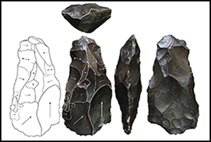
Seven Palaeolithic landscapes were identified in zone 1 and one locality (Yousefabad) was recorded within zone 2 (Figure 1; Table 1). Zone 3 did not yield any lithics or any sign of potential raw material outcrops. In total, 1200 lithics were recorded. Evidence of Middle and Upper Palaeolithic occupation was identified while possible evidence for the Lower Palaeolithic is scant and inconclusive. The eight Middle/Upper Palaeolithic landscapes are all located on dissected inactive Pleistocene alluvial fans and old river terraces, which have been exposed due to aeolian deflation and erosion by surface runoff. Almost all the lithics are coated with a thick dark-brown layer of desert varnish (Figure 2). Nearly half of the lithics are debitage, while tools and cores make up about 29.5 per cent and 11 per cent of the total assemblages, respectively. With the exception of Yousefabad, the assemblage at each locality is flake-based, with direct hard hammer blows and traces of the Levallois method in about five per cent of the specimens. The diversity of flake tools exceeds that of laminar tools. Diagnostic pieces include some massive and fine side scrapers, retouched points with hafting evidence, Levallois points and very few atypical Levallois cores (Figure 2). In addition, three bifaces were recovered, among them are an amygdaloid-lanceate hard hammer handaxe-like specimen (alternatively, symmetrical core-flake) and one keilmesser (Figure 3).
Table 1. The discovered Palaeolithic localities.

EP = Epipalaeolithic; MP = Middle Palaeolithic; N = Neolithic; UP = Upper Palaeolithic.

Figure 2. Selected lithics from Eyvanekey: a–l) attributed to Middle Palaeolithic; a, c–h & l) pieces with basal trimming for hafting(?) with e and g being sidescrapers and f being a convergent scraper; b) Levallois point; i) atypical Levallois flake core; j) elongated Levallois point(?); k) sidescraper on an atypical blade; m–o) attributed to Upper Palaeolithic, artefacts made on blades with negative bladelet scars (figure by authors).

Figure 3. Two bifaces recovered from the survey; above) handaxe(?); below) keilmesser (figure by authors).
Conclusion
The discovery of such extensive lithic scatters with notable densities further highlights the significance of the NICD as a route for Pleistocene hominin dispersal. The extensive distribution of lithics coupled with the existence of different reduction sequences and the diversity of toolmaking bear implications for the frequent use and long-term presence of hominins in the area. Though intermixed, the lithic assemblages could be roughly divided into two parts: one associated with the Middle Palaeolithic (typical flake-based retouched tools, flake cores and the presence of Levallois method), the other with the Upper Palaeolithic (the presence of laminar reduction sequence, soft hammer technique, laminar retouched products with non-prepared butts, and decent numbers of volumetric sub-prismatic blade/bladelet cores) (Figure 3).
Owing to the overall opportunistic (majority of the tool typology is atypical) nature of the assemblages, drawing regional comparisons is difficult. Yet, given the small number of retouched implements and the low intensity of retouch coupled with the importance of the Levallois method, the landscape of Eyvanekey is more comparable with the other Middle Palaeolithic sites within the NICD such as Mirak (Vahdati Nasab et al. Reference Vahdati Nasab2019) rather than those from the Zagros Mousterian (e.g. Lindly Reference Lindly2005). Additionally, the modest use of a not-fully-developed Levallois method in Eyvanekey contrasts with Middle Palaeolithic techno-complexes of the Levant (Shea Reference Shea2013: 105–12) and the Lesser Caucasus (Golovanova & Doronichev Reference Golovanova and Doronichev2003). Yet, the assemblages at Eyvanekey share some similarities with more opportunistic Middle Palaeolithic entities at sites such as Teshik Tash along the putative Northern Dispersal Corridor (Nishiaki & Aripdjanov Reference Nishiaki and Aripdjanov2021).
This field survey marks the beginning of Palaeolithic research in Eyvanekey. With the archaeological importance of an overlooked area being demonstrated, the next chapter here will be finding in situ archaeological deposits to put the lithics in an absolute chronological context.
Acknowledgements
The survey was conducted under the permission (no.40035209) of the Iranian Center for Archaeological Research.
Funding statement
This research received a grant from the Iran National Science Foundation as research project no.4002243.


