


The current understanding of the geology of the Isle of Mull is rooted in the detailed work of Bailey et al. (Reference Bailey, Clough, Wright, Richey and Wilson1924), resulting from the geological mapping of Mull in the early 20th Century. These authors recognised sheet- and cone-like intrusive features, pillow lavas and deep-seated intrusions that were formed as part of a now deeply eroded volcano. Three volcanic centres were recognised, successively younging to the north-northwest across the centre of the island. These intrusive rocks were interpreted as having been intruded into a succession of dominantly basaltic lavas with subsidiary, more evolved compositions such as hawaiites and mugearites. These relatively flat-lying lavas were erupted unconformably onto a pre-volcanic landscape consisting of variably Moine metasediments, Triassic, Jurassic and Cretaceous sedimentary rocks in different areas of the island along with minor occurrences of Palaeocene sedimentary rocks. Within this lava field, Bailey et al. (Reference Bailey, Clough, Wright, Richey and Wilson1924) identified three lava groups, from oldest to youngest, the Plateau Group, Pale Group of Ben More and the Central Group. This stratigraphy was based on the intrusive relationships of the central volcano with these lavas, a relationship supported by zeolite zones (Walker Reference Walker, Murty and Rao1971) that were mapped as forming concentric zones around the Mull edifice. This edifice underwent significant post-Palaeogene erosion and was thought to have extended c.2200 m above the present-day topography (Walker Reference Walker, Murty and Rao1971).
Following this work, emphasis was placed on the detailed igneous petrology of both the lavas and the intrusive rocks (Thompson Reference Thompson1982; Thompson et al. Reference Thompson, Morrison, Dickin, Gibson and Harmon1986), which explored the melting history of the Mull magmatism. Subsequently, extensive stratigraphical sampling for geochemistry led Kerr (Reference Kerr1995) to formalise the lava geochemical groups. Plateau-type lavas were recorded from the base of the Mull lava pile and included the Staffa magma sub-type (the Staffa magma type of Bailey et al. Reference Bailey, Clough, Wright, Richey and Wilson1924). These are overlain by the Coire Gorm-type lavas that have only been recorded from the summit of Ben More adjacent to the Central Complex. Within the eroded volcanic edifice of the Central Complex, lavas were attributed to the Central Mull Tholeiite type, regarded as being the youngest in the succession.
Subsequently, Emeleus & Bell (Reference Emeleus and Bell2005) used informal lithostratigraphical nomenclature to describe the Mull lava pile. This divided the lavas into the Staffa Lava, Mull Plateau Lava and Mull Central Lava formations within the Mull Lava Group. However, no stratotypes or formation boundaries were defined by these authors and the relationship to the geochemically defined lava types (e.g., Kerr Reference Kerr1995) remained unclear. A different approach to the stratigraphy of the lower part of the Mull lava pile was taken by Jolley et al. (Reference Jolley, Bell, Williamson and Prince2009) and Williamson & Bell (Reference Williamson and Bell2012). These authors used a common lava sequence stratigraphy derived from field mapping of lava units and interbedded sedimentary rocks, focussing on outcrops of the columnar jointed lavas attributed to the Staffa Lava Formation. Williamson & Bell (Reference Williamson and Bell2012), concentrated on the integration of physical volcanology with depositional palaeoenvironmental interpretation of interbedded sedimentary rock units in a framework of field mapping. Using this framework, the Staffa Lava Formation, bounded by sedimentary rock units and forming the base of the Mull Lava Group, was defined. the formation of cooling joints and their scaling in the lava flows on Staffa are documented by Phillips et al. (Reference Phillips, Humphreys, Daniels, Brown and Witham2013). Strong structural control on the distribution of the Staffa Lava Formation is recorded (Jolley et al. Reference Jolley, Bell, Williamson and Prince2009; Williamson & Bell Reference Williamson and Bell2012), with largely NW–NNW trending faults defining graben structures that influenced both lava and sedimentary rock unit thicknesses and facies.
Structural control on a larger scale is also clear from detailed mapping of the fold belt to the southeast of Centre 1 in the Central Complex (Bailey et al. Reference Bailey, Clough, Wright, Richey and Wilson1924). Mathieu & van Wyk de Vries (Reference Mathieu and van Wyk de Vries2009) presented a re-evaluation of this area, combining field mapping with laboratory experimentation, to suggest that the fold belt resulted from a series of intrusion-related deformation events. Marked by decollement horizons at the contact between the lavas and underlying Mesozoic rocks on the south coast of the Croggan Peninsula (Fig. 1), the south-eastern sliding of the volcanic edifice was likely related to the formation of Centres 2 and 3 of the Central Complex. The dextral strike slip fault bounding the eastern side of these thrust features was identified west of Loch Buie, changing the perceived field relationship of the lava field in this area.
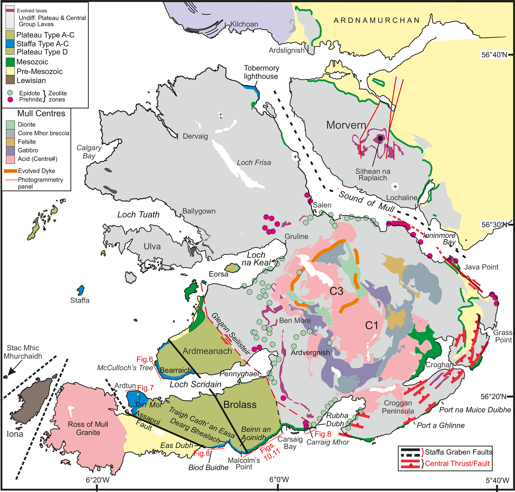
Figure 1 Location map.
Despite this extensive history of research on the Mull Lava Group and in particular on the columnar jointed rocks of the Staffa magma type (sensu Bailey et al. Reference Bailey, Clough, Wright, Richey and Wilson1924), there is a noticeable lack of integration between field and geochemical evidence for the eruption history of lava fields in SW Mull. Photogrammetry has previously been used to study lava fields (e.g., Pedersen et al. Reference Pedersen, Watt, Watt and Larsen1997; Famelli et al. Reference Famelli, Millett, Hole, Lima, Carmo, Jerram, Jolley, Pugsley and Howell2021; Jolley et al. Reference Jolley, Passey, Vosgerau and Sørensen2022a) and in the present study has facilitated the re-investigation of the relationships of volcanic and sedimentary rock units in SW Mull. In addition, even with the extensive stratigraphic sampling for geochemistry on Mull (Kerr et al. Reference Kerr, Kent, Thomson, Seedhouse and Donaldson1999), many parts of the Staffa Lava Formation have only limited or incomplete geochemistry, restricting the application of geochemical stratigraphy and correlation that has been successfully applied in other lava fields of the province (Larsen et al. Reference Larsen, Waagstein, Pedersen and Storey1999; Millett et al. Reference Millett, Hole, Jolley and Passey2017, Reference Millett, Jerram, Manton, Planke, Ablard, Wallis, Hole, Brandsen, Jolley and Dennehy2021). Within this study, results from five photogrammetry models covering key exposures of the earliest Staffa Lava Formation in SW Mull are presented. Interpretation of these models, coupled with field-based calibration, was used to design a sampling strategy for new targeted palynological and lava geochemical analyses. Integration of photogrammetry, fieldwork and new sampling has enabled re-evaluation of the evolution of the early Mull lava fields, revealing systematic changes in magma-genesis separated by distinct volcanic hiatuses during which time-complex and diverse ecosystems developed within the SW Mull graben system. Importantly, the results of this study clearly demonstrate that lava field facies (such as columnar jointed lava flows) cannot be used to correlate isolated outcrops and should not form the basis for correlation or formation definition.
1. Methods
1.1. Photogrammetry data capture
Lithology, facies and rock unit interrelationships were collected from outcrops in the field. Many of these have been recorded previously (e.g., Williamson & Bell, Reference Williamson and Bell2012) and are supplemented here with additional data. Assessing the interrelationships of rock units on the kilometre scale is challenging in the study area due to limitations of exposure and accessibility of the steep cliffs. To circumvent this problem, photogrammetry data were collected from cliff sections on the southwest and east coast of Mull (Fig. 1). Photographs were collected by drone using a DJI Phantom 4 Pro model with a mounted camera FC6310; the sensor user was 1″ CMOS with 20 Megapixels and stabilisation of the DJI was fixed by GPS/Glonass accuracy. Photogrammetry models were prepared using Agisoft Photoscan 1.4.5 at the University of Aberdeen. Resulting photogrammetry models were interpreted using LIME v2.2.2 (Buckley et al. Reference Buckley, Ringdal, Naumann, Dolva, Kurz, Howell and Dewez2019; Greenfield et al. Reference Greenfield, Millett, Howell, Jerram, Watton, Healy, Hole and Planke2019), the models being cross-referenced to field photographs, existing sample locations and field records. The models were interpreted in detail, using colour-coded lines to characterise different volcanic and sedimentary beds. More extensive features (e.g., faults, large-flow unit tops and unconformities) were highlighted to allow tracing of eruptive and depositional packages. These extensive features, stratigraphic boundaries and model textures were exported as orthorectified interpretation panels presented throughout this paper. All virtual outcrop models presented in this study can be accessed on the v3Geo viewer (www.v3Geo.com).
Examination and interpretation of the photogrammetry models was a key stage in the creation of a field sampling programme designed to address gaps in the existing lithological, geochemical and palynological database. Integration of the photogrammetry models with remote sensing surface data from publicly available platforms (Google Earth, Bing Maps) allowed an improved understanding of field exposure patterns. Subsequent fieldwork was used to ground truth the photogrammetry models in the case of lithological uncertainty and to locate and collect new samples.
1.2. Basalt geochemistry
In total 41 samples were collected and analysed for major, trace and rare earth element (REE) geochemistry by combined X-ray fluorescence and inductively coupled plasma mass spectrometry at the Peter Hooper GeoAnalytical Lab, Washington State University, Pullman, Washington (Supplementary Data S1 available at https://doi.org/10.1017/S1755691023000191). Standard laboratory protocols were followed (see Knaack et al. Reference Knaack, Cornelius and Hooper1994). Full details of methods can be found at https://environment.wsu.edu/facilities/geoanalytical-lab/ and in Soderberg & Wolff (Reference Soderberg and Wolff2023). Loss on ignition (LOI %) for the samples ranged from 0.9 to 6.2, with an average of 2.8 wt% indicative of the altered state (presence of hydrous alteration minerals) of some of the samples. This range of values is regarded as acceptable for the mixed alteration basaltic sample suite; however, care was taken to test petrological hypothesis with incompatible and immobile elements including the REEs that are less susceptible to secondary redistribution (Morrison Reference Morrison1978).
1.3. Palynology
Samples were taken for palynological analysis from shales, coals and poorly sorted sandstone units in field sections. These were processed following standard techniques, including hydrofluoric acid digestion, boiling in 37 % hydrogen chloride to remove precipitates and oxidation for 5 min in dilute 70 % nitric acid where necessary. Coal samples were prepared by dissolution using fuming nitric acid. The resultant >7-μm residues were mounted in a permanent petropoxy mounting medium and examined under a transmitted light Olympus BX53 microscope. For each sample, counts of 250 specimens were targeted, but with the highly variable recovery from inter-lava field sedimentary rocks, frequently not attained (Supplementary Data S2). Accordingly, data were normalised as percentages in sections where larger counts were obtained and as square roots in more variable recovery sections.
1.4. Statistical analysis of laboratory data
Both the basalt geochemistry and palynology data sets compiled for this study were complex, with relatively high numbers of variables. Univariate statistical analysis of the palynological data particularly, proved inconclusive in relation to lava stratigraphy. Relating the whole composition of both the palynological and basalt geochemical data to the photogrammetry model and via that to the stratigraphy of the lava field was of primary importance. With a large REE geochemical data set, it was necessary to obtain a quantifiable and clear overview of differences and similarities in these data to characterise exposed lava fields. An approach that did not place significance on any pre-selected element was initially preferred. Avoiding pre-selection could elucidate relationships in the total REE composition of samples that might potentially be obscured.
Accordingly, detrended correspondence analysis (DCA) of the normalised REE data set was undertaken. This algorithm treated the data as numbers in a contingency table; no greater or lesser emphasis is placed on any component of these data. Comparisons between this approach and one solely using ratio–ratio plots has shown that DCA was effective in quantifying the whole data set relationships between clusters of similar REE compositions (Fig. 2). Identification of the spatial relationships of these clusters was necessary for the analysis of lava field stratigraphy. Quantifiable measurement of spatial variation in the REE composition of erupted lava flows provides a stratigraphy that can then be followed by more traditional data analysis to determine petrogenetic histories.
Analysis of potential trends in the distribution of the palynological (Fig. 3) data sets was also undertaken using DCA. This analysis was preferable for the analysis of whole spectrum data sets (in this case both geochemical and palynological), as it assumes a unimodal response to any compositional gradient. DCA was selected in preference to correspondence analysis (CA) as the algorithm counteracts the parabolic arch effect seen under certain data conditions in CA (Hammer & Harper Reference Hammer and Harper2008). DCA also rescales the end of the axes, which in CA can become compressed, distorting the extremities of the graphical output (Hill & Gauch Reference Hill and Gauch1980). The eigenvalues derived from DCA are a coefficient reflecting the degree of species or element dispersion along an axis (Ter Braak Reference Ter Braak1986; Kovach Reference Kovach2002). The strongest compositional gradient typically causes the largest variation in species/element composition (Versteegh & Zonneveld Reference Versteegh and Zonneveld1994), the majority of the variation being expressed by the first two axes. Plots of these two axes (Figs 2, 3) were used to identify clusters of samples or taxa that have similar distributions within the data set.

Figure 2 (a) Plot of axis 1and axis 2 for the detrended correspondence analysis of the REE data set. The eigenvalues and cumulative percentages for this analysis are shown in 3a, with 88 % of the variation in the data being included in the first two axes. (b–e) Primitive mantle-normalised multi-element plots and chondrite-normalised REE and plots for samples analysed in this study with their position on the DCA plot shown in 3a. The REE and multi-element profiles for Fingal's Cave lava St-1.1 (this study) is shown by the pecked red line in each diagram line for comparison. Normalizing values are from Sun & McDonough (Reference Sun, McDonough, Saunders and Norry1988). Samples prefixed ‘BM’ are from Kerr (Reference Kerr1993). A full list of sample locations is contained in Supplementary Material S1. Abbreviations: REE = rare earth element; BM = Ben More.

Figure 3 Interbed pollen and spore data DCA plots of axis 1 and axis 2. Data from each of the main correlative interbeds were analysed separately and the axis 1–axis 2 cross-plots interpreted individually. (a) Eas Dubh Interbed, (b) Staffa–Plateau Interbed, (c) Ardtun Interbed. Abbreviations: DCA = detrended correspondence analysis; FG = fern-Ginkgo community; EMS = early to mid-successional community; CM = channel margin community; TS = transitional swamp community; PS = peat swamp community; ML = moisture-limited community; S = true swamp community.
1.4.1. Palynology data
Before subjecting the raw palynology data to multivariate analysis, data from each interbed surface was combined into separate contingency tables. Correlation of interbed surfaces was undertaken using the photogrammetry models, combined with field data. Using this approach, three major interbed series were identified and their palynological records were grouped in tables. These tables contained all palynomorph records including singletons and low frequency taxa. Such occurrences result in a ‘noisy’ data set that obscured ecological trends. Accordingly, samples with a total palynomorph count of less than 20 were removed from the contingency tables. Then, to compensate for the variation in total palynomorph abundances, the contingency tables were normalised to percentages. Finally, rare taxa with a cumulative percentage of <5 % were removed from the contingency tables.
Analysis of the three interbed groups in the SW Mull Lava Field resulted in three separate palynology DCA models. This was done to eliminate the dilution of less frequent taxa by pollen from overproducing gymnosperms that dominate higher-energy environments. The environmental significance of clusters identified on the axis 1 and axis 2 cross-plots was interpreted with reference to the known botanical affinities and ecological niches of the taxa or groups of taxa recorded (e.g., Jolley & Whitham Reference Jolley and Whitham2004; Daly et al. Reference Daly, Jolley, Spicer and Ahlberg2011; Vieira & Jolley Reference Vieira and Jolley2020). The environmental significance of each group was used to derive group names, which were kept consistent across the three models (Fig. 3). For each model, each location was summed and the frequency of the palaeoenvironmental groups plotted as a pie chart.
1.4.2. REE data
For the analysis of stratigraphical distribution trends within the lava flows sampled for geochemistry, rare earth element (REE) data were selected for their petrological significance along with their typically lower susceptibility to post-emplacement alteration and hydrothermal re-mobilisation. In addition to these new samples, a small number of published samples with REE data were included (Morrison Reference Morrison1978; Kerr Reference Kerr1995)
All REE data were chondrite normalised (McDonough& Sun Reference McDonough and Sun1995) and prepared as a single contingency table. These multivariate data were subsequently subjected to unguided analysis without any pre-selection or weighting of elements. The objective of this analysis was to identify samples with statistically robust similarities in REE compositions that were then used to support the detailed petrological interpretation of the separate groupings. Groups identified in this manner could then be used to characterise flow units or sequences of flows outcropping in different locations across the study area to test and support correlations (Fig. 2).
A plot of samples from the two primary axis of the REE DCA identified clear groupings of samples. These groupings were defined by their similarity in eigenvalues and interpreted with reference to their major and trace element ratio–ratio profiles (Fig. 2). These profiles were used to derive names for each cluster of samples, reflecting their affinity to a Staffa magma type, a Plateau magma type or groups outside these fields. It is significant that the overall distribution of these groups reflects the geochemical composition. In the case of the Staffa types (Fig. 2), the eigenvalue distance between the different Staffa-type REE cluster reflects down-temperature fractionation.
2. Results
2.1. Geochemistry of Mull lava flows, Staffa–Plateau comparison
In this section, the geochemistry of new samples collected for this study are compared with published data for Plateau and Staffa magma types. The contrasting major element behaviour between the Staffa lavas and Plateau lavas of Ben More are illustrated in Figure 4. Staffa lavas are more evolved (4.5–7.8 wt% magnesium oxide (MgO)) than Plateau lavas (4.5 to >14 wt% MgO), with picrites dominating in Plateau successions (Kerr et al. Reference Kerr, Kent, Thomson, Seedhouse and Donaldson1999). Staffa lavas have higher silicon dioxide (SiO2) and lower aluminium oxide (Al2O3) for a given MgO content than Plateau lavas and exhibit a characteristic steep positive covariation between calcium oxide (CaO) and MgO (Fig. 4).

Figure 4 (a) SiO2, (b) Al2O3 and (c) CaO versus MgO (all wt%) for Mull plateau lavas and Staffa-type lava. Mull plateau lavas are represented by the Ben More succession (Kerr et al. Reference Kerr, Kent, Thomson, Seedhouse and Donaldson1999) and Staffa lavas are from Thompson et al. (Reference Thompson, Morrison, Dickin, Gibson and Harmon1986), Kerr (Reference Kerr1998), Kerr et al. (Reference Kerr, Kent, Thomson, Seedhouse and Donaldson1999) and Hole et al. (Reference Hole, Millett, Rogers and Jolley2015). Staffa lava localities are Ardtun Head, Malcolm's Point, Wilderness, Burg and Fingal's Cave (Staffa). Black arrows are schematic LLD taken from Hole (Reference Hole2018). In (a) LLD are shown for ~1 GPa and 101.325 kPa and in (b) at variable pressures from 101.325 kPa to 2 GPa as indicated in the figure. Note that at 1 GPa, Cpx (mildly aluminous) joins the liquidus before plagioclase whereas at 101.325 kPa plagioclase joins the liquidus before augite. This results in higher Al2O3 for lavas with MgO < 8 wt% that crystallise at 1 GPa compared with those that crystallise at 101.325 kPa. In (b) published Staffa lava data fall close to the predicted 101.325 kPa L + Ol + Pl + Aug cotectic. Abbreviations: LLD = liquid-lines-of-descent; Cpx = clinopyroxene.
On the expanded Nephaline–Hypersthene–Olivine–Quartz (Ne–Di–Ol–Hy–Qz) normative tetrahedron (Fig. 5), data for Plateau lavas occupy a field with <20 wt% normative Di that straddles the Di–Ol join; a significant proportion of Plateau lavas are Ne-normative. By contrast, Staffa lavas form a coherent trend from the Ol–Di join with <20 normative Di, towards the Di–Hy join. The more evolved Staffa lavas are mildly Qz-normative (maximum 4.8 wt% Qz).

Figure 5 Expanded CIPW normative (wt%) basalt tetrahedron projected from or towards plagioclase onto the planes neon–diopside–olivine–hellyerite–quartz (Ne–Ol–Di–Hy–Qz). Data sources as for Fig. 1 except for the Rubha a’ Chromain composite sill that is from Preston (Reference Preston2001). Crosses in the Plateau lava data field represent a range of model primary magma compositions for the region (Hole & Millett Reference Hole and Millett2016) with melting decreasing towards and beyond the Ol–Di join. The star in circle is an estimated model primary magma to the Staffa lavas. The inset (right) illustrates the predicted LLDs for a model BPIP primary magma derived from Skye lava SK982 (star in circle; Hole & Millett, Reference Hole and Millett2016) at 101.325 kPa and 1 GPa. These were calculated using Petrolog3 (Danyushevsky & Plechov Reference Danyushevsky and Plechov2011) using the Ol model of Beattie et al. (Reference Beattie, Ford and Russell1991) and plagioclase and augite models of Danyushevsky (Reference Danyushevsky2001). The QFM buffer was that of Kress & Charmichael (Reference Kress and Charmichael1988) and QFM-1 was assumed. Note that at 1 GPa, Cpx (aluminous) joins the liquidus before plagioclase such that the LLD moves towards more Si-undersaturated compositions with decreasing MgO and may ultimately cross the Ol–Di join. At 101.325 kPa, plagioclase joins the liquidus before augite and the LLD projects towards the Di axis; thereafter, crystallisation along the L + Ol + Pl + Aug cotectic results in final liquids occupying an area in the Di-Hy-Qz field of the diagram. Staffa lavas follow the 101.325 kPa LLD whereas, typically, plateau basalts follow the 1 GPa LLD (Thompson Reference Thompson1982; Hole et al. Reference Hole, Millett, Rogers and Jolley2015; Hole Reference Hole2018). Abbreviations: CIPW = Cross, Iddings, Pirsson and Washington norm; LLD = liquid-lines-of-descent; BPIP = British Palaeogene Igneous Province; QFM = quartz–fayalite–magnetite; Cpx = clinopyroxene.
The differences in normative characteristics and major element compositions of Staffa and Plateau lavas are primarily a result of crystallisation at different depths, with the Staffa lavas crystallising at <0.5 GPa and Plateau lavas >1.0 GPa. O'Hara (Reference O'Hara1968) showed that with increasing pressure of crystallisation, the liquidus field of Ol contracted and the field for clinopyroxene crystallisation expanded at the expense of Ol. At ~1 GPa Al-augite joins Ol on the liquidus before plagioclase, whereas at <0.5 GPa plagioclase joins Ol before crystallisation along the Ol + Pl + Aug cotectic. This is manifest in Figure 4 by the contrasting behaviours of SiO2, CaO and Al2O3 between the two magma types. Because Al-augite is Si-saturated to over-saturated but CaO-rich, its early crystallisation results in near constant or slightly decreasing SiO2 with decreasing MgO (Fig. 4) and lower CaO for a given MgO content compared with magmas crystallizing at <0.5 GPa. Similarly, the differing Al2O3–MgO trends shown in Figure 4 result from suppression of early plagioclase crystallisation at ~1 GPa. Hole (Reference Hole2018) showed, on the basis of the trace element contents of Ol, that some picrites from the Ben More succession (e.g., BR2 and BR6; Kerr Reference Kerr1995) are likely to have first crystallised Ol at ~1.6 GPa and ~17.5 wt% MgO followed by Al-augite at ~14 wt% MgO. These basalts also exhibit the lowest CaO for a given MgO content (Fig. 4a) and the degree of CaO depletion compared with magmas crystallizing at <0.5 Gpa is a reasonable proxy for pressure of crystallisation (Hole Reference Hole2018).
In terms of normative characteristics, magmas crystallising at <0.5 Gpa and ~1.0 Gpa exhibit down-temperature trends in opposite directions in Figure 5, such that at <0.5 Gpa more evolved magmas (<5 wt% MgO) will be Qz-normative, whereas at ~1.0 Gpa evolved magmas will be Ne-normative (Thompson Reference Thompson1982; Hole et al. Reference Hole, Millett, Rogers and Jolley2015; Hole Reference Hole2018). Hole & Millett (Reference Hole and Millett2016) provided a suite of model primary magmas for the British Palaeogene Igneous Province (BPIP) calculated using Primelt3 (Herzberg & Asimow Reference Herzberg and Asimow2015), the normative characteristics of which are shown in Figure 5. It is important to note that the primary magmas from which the Plateau and Staffa magma types were derived by fractional crystallisation may cover a similar range of compositions, it is only their pressure of crystallisation that differs. Kerr (Reference Kerr1998) similarly noted that the parental magmas to the Staffa lavas might lie within the Hy-normative or Ne-normative volumes of Figure 5, with normative character of primitive lavas being mainly determined by the extent of melting, Ne-normative parental magmas being the smallest melt-fractions (Hole & Millett Reference Hole and Millett2016; Hole et al. Reference Hole, Pugsley, Jolley and Millett2023).
Trace element characteristics of Plateau and Staffa lavas are shown in Figure 2. Plateau-type lavas have convex upwards chondrite-normalised REE profiles with flat patterns from lanthanum (La) to neodymium (Nd) (chondrite-normalised La/Nd; [La/Nd]N ≤ 1) but with [La/ytterbium (Yb)]N in the range 2.0–5.1. These shapes of REE profiles have been explained by partial melting of light REE-depleted mantle peridotite in the garnet-spinel transition of the upper mantle (Kerr Reference Kerr1995; Hole et al. Reference Hole, Millett, Rogers and Jolley2015). In contrast, more mafic (>5 wt% MgO) Staffa-type magmas are characterised by planar REE profiles with higher [La/Nd]N (1.2–1.7) and [La/Yb]N (2.4–4.8) than Plateau types (Fig. 2). More evolved Staffa lavas with <5 wt% MgO are light REE enriched ([La/Yb]N > 4.3) and develop a small but appreciable negative europium (Eu) anomaly (Eu/Eu*~0.9) consistent with early plagioclase crystallisation.
Primitive mantle-normalised multi-element plots (Fig. 2) reveal that Staffa lavas have a pronounced trough at niobium (Nb) and tantalum (Ta) compared with adjacent elements (e.g., potassium (K), La) and have thorium (Th)/Ta (5.5–8.8) that are considerably higher than for any Plateau-type lavas (Th/Ta < 3). La/Ta covers a similar range for both Staffa (34–55) and Plateau (27–45) types, the highest La/Ta being for Staffa B lavas. Variations in Th/Ta and La/Ta in BPIP lavas, which also exhibit well-defined covariations with isotopic compositions, can be attributed to the results of crustal contamination (Thompson et al. Reference Thompson, Gibson, Marriner, Mattey and Morrison1980, Reference Thompson, Dickin, Gibson and Morrison1982; Kerr et al. Reference Kerr, Kempton and Thompson1995; Hole et al. Reference Hole, Millett, Rogers and Jolley2015, 2023). Staffa lavas are considered to have interacted with upper-crustal country rocks and represent the most contaminated lavas in the BPIP. This results in Th/Ta being considerably greater than likely mantle source values of Th/Ta~1. For the Staffa lavas, Th/Ta also increases from ~3 at 10 wt% MgO to ~9 at 4 wt% MgO. This means that the more evolved Staffa lavas cannot be related to the more mafic Staffa lavas by simple fractional crystallisation, and assimilation with fractional crystallisation is the most likely explanation for these geochemical variations.
Plateau lavas do not exhibit the high Th/Ta of Staffa lavas but have La/Ta up to 55 (Thompson et al. Reference Thompson, Dickin, Gibson and Morrison1982). This has been interpreted as a result of contamination of Plateau lavas with low Th/Ta but high La/Ta Lewisian granulite at the base of the crust, which is also consistent with their high-pressure crystallisation signature (Thompson et al. Reference Thompson, Dickin, Gibson and Morrison1982; Hole et al. Reference Hole, Millett, Rogers and Jolley2015). In Figure 4, this gives rise to the consistently low normalised abundances of uranium (U), niobium (Nb), Th and Ta in Plateau-type lavas, which is a feature not evident in the Staffa lavas.
2.2. Photogrammetry panels
Photogrammetry interpretation panels were created from data collected in five locations in SW Mull (Fig. 1). These panels are described from northwest to southeast.
2.2.1. Ardmeanach Peninsula
The oldest rocks exposed on the foreshore are described as pyroclastic–volcaniclastic deposits (Williamson & Bell Reference Williamson and Bell2012) and overlie the Gribun Chalk Formation that is exposed on the foreshore to the north (Jolley et al. Reference Jolley, Bell, Williamson and Prince2009; Fig. 6). The upper ~3 m of the volcaniclastic conglomerate unit is exposed, showing crude low-angle cross-stratification formed by fluvial deposition of reworked volcaniclastics (Fig. 6iii). These beds include several >75-cm-wide flattened large branch or trunk wood fossils, lacking preserved cellular structure. Locally overlying the volcaniclastic conglomerate is a thin carbonaceous shale. This shale was probably the growth substrate for numerous large trees, including the upright petrified Taxodioxylon wood fossil and mould of MacCulloch's Tree (Fig. 6iv). To the south, trace fossils referred to as ‘daisy wheels’ (Williamson & Bell Reference Williamson and Bell2012) originated as sub-horizontal radial cooling joints, propagated around subsequently rotted trees (Fig. 6ii). This overlying columnar jointed flow is laterally extensive with a colonnade up to 30 m in thickness. Multivariate analysis of the REE profile of this flow (Fig. 2) shows it to be of a composition closely similar to the Great Face flow on the Isle of Staffa to the northwest.

Figure 6 MacCulloch's Tree section photogrammetry panel. The overall uninterpreted panel at the top of the figure shows the extent of panel sections (a) and (b); the location of the panel is shown in Fig. 1. On the interpreted photogrammetry sub-panels (a) and (b), coloured shading is used to highlight strata (see Fig. 7 for colour key), but is restricted to exposed strata. The extent of unconformities and interbeds, however, are inferred between exposures. The frequency of pollen and spore community groupings are shown as pie charts. Data from the Ardtun Interbed and the older interbed underlying the Staffa Type A flow (photograph (i)), which enveloped MacCulloch's Tree (photograph (iv)), are shown separately although they use the same DCA model. Both show dominance of true swamp community pollen, mostly derived from swamp cypresses. Corresponding cupressaceous fossil wood is common, including MacCulloch's Tree, > 0.5 m wide branch wood preserved in the clinoforms at the top of the basal volcaniclastic unit (photograph (iii)) and most probably the ‘daisy wheel’ cooling joint structures (photograph (ii)) within the Staffa Type A flow.

Figure 7 Ardtun Head photogrammetry panel. The photogrammetry panel (a) highlights the position of the Ardtun Leaf Beds exposed in Ardtun gully between flows of Staffa Type A REE composition. These flows are of significantly different facies (photograph (e)), the sedimentary rocks being laid down on top of an interval of basaltic spatter and ash (photogrammetry model (b)). The basal lacustrine Ardtun Leaf Bed facies is prominently in-weathered and probably exposed at the base of the unit in the next gully to the west (photograph (e)). Matrix-supported conglomerates with prominent clinoforms characterise the thickest beds of the Ardtun Leaf Beds at Ardtun gully (photograph (d)). In the gully to the west, this unit is composed of sub-horizontal, finely bedded pebbly sandstones (photograph (c)). It is possible that this change in facies is linked to control by the NW–SE trending faults, subsequently eroded out to form the present gullies. However, scree and grassy dead ground obscure the relationships of these units. A Staffa Type B flow with a basal peperite rests on the eroded entablature of the oldest Staffa Type A flow at the west of the exposure. Although separated by marshy dead ground from the Aoineadh Mor cliffs formed from the younger Staffa Type A flow lobes, the Staffa Type B flow occurs at the stratigraphical level of the Ardtun Interbed (Ardtun Leaf Beds) to the east. The Ardtun Interbed can be traced from the gully exposures west round the cliff into dead ground below the Aoineadh Mor cliffs formed from Staffa Type A flow lobes.
Above this Staffa Type A flow is a prominent interbed; <1 m in thickness, it includes shales, immature drifted coals, fine sandstone beds and calcareous cemented mudstones. This sedimentary rock succession was attributed to genetic sequence GSA5 by Williamson & Bell (Reference Williamson and Bell2012) and regarded as correlative with the Ardtun Leaf Beds exposed at Ardtun Head to the southwest (Fig. 1). Here, this sedimentary interbed is referred to as the Ardtun Interbed.
Overlying the Ardtun Interbed, further columnar jointed flows are exposed to the north of MacCulloch's Tree. To the east, a prominent unconformity (Jolley et al. Reference Jolley, Bell, Williamson and Prince2009) marks extensive erosion of these flows (Fig. 6). Basalt geochemistry samples taken by the authors and by Kerr (Reference Kerr1993, Reference Kerr1995) from these columnar jointed flows, yielded Staffa-type REE profiles grouped as Staffa Type A (Figs 2, 6). The contact between these Staffa Type A flows and lava flows above the unconformity was intruded by a laterally continuous sill up to 25 m in thickness. Samples of a similar sill exposed at the southern end of coastline interpreted in Figure 6 (at NM413264 and NM414264 in Kerr Reference Kerr1993) yielded compositions compatible with the Loch Scridain Sill Complex (Kerr Reference Kerr1993; Preston et al. Reference Preston, Bell and Rogers1998). A thick succession of simple and compound flows comprises the majority of the cliff exposure above the intruded unconformity. These too are intruded by a series of sheet-like sills (Fig. 6), evident from their transgressive geometry and pale weathering, the latter implying compositional difference. This succession of lava flows overlying the post-Staffa Type A unconformity were also sampled by Kerr (Reference Kerr1995). REE profiles for the lavas exposed to the north at Beinn na h-Iolaire (NM 44378) are comparable to those with REE profiles in a Plateau Type B cluster. Based on currently available data, flows of Plateau Type A composition are not present in the Ardmeanach area, the erosive unconformity separating the Plateau Type B flows from the underlying Staffa Type A.
From analysis of the photogrammetry panel (Fig. 6), it is clear that the Plateau Type B flows in this area are of two different facies. In the area south of Carrachan Mor (Fig. 6), the exposure is dominated by simple lava flows with prominent flow cores. These simple flows are laterally extensive and separated by rubbly lavas or by vegetated ground at the clifftop. It is these ‘traps’ that characterise the Ardmeanach Peninsula when seen from the south and southeast. North of Carrachan Mor, simple flows are only exposed towards the top of the cliffs, the lower cliff being dominated by sheet-like sills. At the extreme northwest extent of the panel (Fig. 6a), the upper cliff is dominated by compound flows, no significant simple flows being present. Synchronous eruptions of different lava morphologies comparable to this have been recorded previously in the Faroe Islands Basalt Group (Passey & Jolley Reference Passey and Jolley2009).
2.2.2. Ardtun Head
A smaller photogrammetry panel was prepared from the north-facing cliffs at Ardtun Head (NM 37610 24765; Fig. 7a), including the Ardtun Leaf Beds (Argyll Reference Argyll1851; Bailey et al. Reference Bailey, Clough, Wright, Richey and Wilson1924). Here, the exposure down to low water mark is dominated by a strongly columnar jointed flow, the columns often being curved with orientations varying from sub-horizontal to sub-vertical, a feature likely related to cooling perpendicular to an irregular surface. In the Ardtun gully where the leaf beds are best exposed, low water level exposes the underlying volcaniclastic conglomerate seen at MacCulloch's Tree and the pyroclastic–volcaniclastic beds on the Isle of Staffa below the Great Face columnar Staffa Type A flow (Fig. 2). Limited exposures of the volcaniclastic conglomerate at Ardtun Head exhibit an irregular upper surface, overlain by the prominent columnar lava. This contrasts with the planar upper surface and regular vertical colonnade of the corresponding sequence of the Ardmeanach Peninsula to the northeast.
The oldest columnar jointed flow (Fig. 7) on Ardtun Head has a REE composition identical with Staffa Type A flows, including the Great Face flow from the Isle of Staffa (Fig. 2). In the upper part of the Ardtun Head flow, inclined beds of scoria and basaltic ash, together with some poorly defined pillow structures, suggest emplacement into a wet environment, potentially with the development of local rootless cone-style volcanism, a feature commonly found in relation to lava flows in wet environments in Iceland (Boreham et al. Reference Boreham, Cashman, Rust and Höskuldsson2018).
On the north coast of the Ardtun Peninsula, the columnar jointed Staffa Type A flow and associated scoria are overlain by the Ardtun Leaf Beds. This interbed is heterolithic, the oldest beds in the Ardtun gully with bedded shales and limestones, the shales possibly deposited by hyperconcentrated flow into a lacustrine environment. These deposits are overlain by dominantly fluvial sandstones and conglomerates with prominent clinoforms. Here termed the Ardtun Interbed, photogrammetry combined with field observations indicate that thickness and facies in this bed vary laterally, controlled either by local faulting (Fig. 6) or pre-existing flow top topography.
Sedimentary rocks of the Ardtun Interbed on the north coast of the peninsula are directly overlain by a crudely columnar to prismatically jointed thick lava flow (Fig. 7). Geochemical analysis of a sample from this flow demonstrated that its REE profile is also clustered within Staffa Type A (Fig. 2). Although this younger Staffa Type A flow was deposited as a series of flow lobes (Fig. 7), it is correlative with the multiple columnar jointed Staffa Type A flows above the Ardtun Interbed on the Ardmeanach Peninsula. The western part of Ardtun Head has provided evidence of a more complex stratigraphy. North of Rubha Breac (NM 37376 24503), the eroded colonnade of the lower Staffa Type A flow forms a NE–SW ridge of southward-dipping small columns. In the accommodation space created by this topography, a columnar jointed flow with a peperite base was erupted, ponding against the eroded older flow. The peperite is thin (<1 m) and extends for ~30 m northwards over the foreshore, the original sedimentary unit appearing to have been a fine-grained sandstone. Although separated by a relatively flat piece of dead ground (Fig. 7), the younger, prismatically jointed Staffa Type A flow extends above the peperite-based flow round to Aoineadh Mor. Analysis of the REE profile of this peperite-based flow shows that it is clustered with a different set of Staffa-type REE profiles, referred to as Staffa Type B (Fig. 2).
Basaltic lavas at Ardtun Head are intruded by a thick sill with tachylitic margins (Bailey et al. Reference Bailey, Clough, Wright, Richey and Wilson1924) and a varying relationship to the intruded succession (Fig. 7). It appears to have exploited the fragmental tops of flow units, cross-cutting the younger Staffa Type A flow in several locations. The sill becomes geometrically complex to the north of the peninsula where it reveals intricate spherulitic pitchstone textures. Ardtun Head is geomorphologically characterised by a flat upper surface dipping at low angle to the SSE, on which sit outliers of younger lavas. One of these at Tor Mor (NM 38376 24371; Fig. 1) on the eastern part of this surface partly exposes a compound flow sampled by Kerr (Reference Kerr1993) and attributed to a plateau geochemical type. Currently lacking REE data, but taking into account the succession to the northeast at Bearraich, this flow is probably comparable to Plateau Type B, the planar surface of Ardtun Head being the exhumed post-Staffa-type unconformity.
2.2.3. Biod Buidhe to Tràigh Cadh’ an Easa
Exposed on the foreshore at Biod Buidhe on the south coast of the Brolass Peninsula, this foreshore and cliff exposure forms the western extent of outcrops stretching from the Assapol Fault east to Carsaig Bay (Fig. 8). The western margin of the lava outcrop is defined by the NW trending Assapol Fault (NM 44750 19180), which juxtaposes Moine psammites against the basalt succession. Basaltic dykes were intruded up the Assapol Fault after the extrusive lavas were emplaced, now showing evidence of extensive shearing by movement of the fault. East of the Assapol Fault, a series of columnar jointed basalt flows form the foreshore and low cliffs. Orientation of the columns in these flows towards the Assapol Fault reveals no clear deflection, which could provide evidence of cooling against the Assapol Fault.

Figure 8 Assapol Fault–Biod Buidhe photogrammetry panel. The uninterpreted photogrammetry panel is shown at the base of the figure, highlighting the extent of the interpreted magnified sub-panels, (a) and (b). Coloured overlays are as in Figure 7 and are restricted to exposed strata. The oldest lava flow crops out adjacent to the Assapol Fault (sub-panel (a)) and is of Staffa Type B composition and has a well-developed columnar jointed fabric. The upper ~1 m of this flow is composed of scoria and cow-pat bombs, but also includes branch wood (see Fig. 9b). Underlying this flow is a sandstone interbed of uncertain thickness. A second heterolithic interbed crops out on top of the Staffa Type B flow, in turn being overlain by a columnar jointed Staffa Type A lava flow. These two interbeds are stratigraphically equivalent to the Ardtun Interbed at Ardtun Head. Sub-panel (b) shows the change in character of the lava succession at the Staffa–Plateau interbed, the dominance of Plateau Type B and Plateau Type A compound flows resulting in much grassy dead ground. Marked by a prominent Plateau Type B flow at the top of the cliffs, the Eas Dubh Interbed is best exposed just to the west of sub-panel (a) in a wooded area at the base of the Eas Dubh waterfall.
A <1-m-thick volcaniclastic sandstone interbed is exposed at low tide level adjacent to the Assapol Fault (NM 44750 19180; Fig. 8). The sandstone is overlain by a strongly columnar jointed basalt lava flow forming much of the Biod Buidhe foreshore, the flow has a rubbly flow top that includes scoria, cow-pat bombs and entrained branch wood (Fig. 9ii). This, the oldest exposed flow, is attributable to Staffa Type B (Figs 3, 8). The irregular topography of this rubbly flow top formed a depocentre to the north, in which a complex of fluvio-lacustrine sediments were deposited (Fig. 9a). Exposures of this interbed on the foreshore host thin pale-coloured sills of evolved composition. Facies range from red-brown, poorly sorted fine sandstones with crude cross-bedding near the Assapol Fault to granule grade, polymictic conglomerates and interbedded calcareous silty sandstones and sandstones in Biod Buidhe Bay (NM 45072 19229). Here, organic shales with carbonaceous streaks pass laterally into thin beds of white limestone composed of ferroan calcite (Fig. 8e). Preserved by a sill to the east of this exposure, shales at the base of this interbed show broadleaf fossils in a leaf mat, laid down over a surface with prominent syneresis cracks.

Figure 9 (a) View west over Biod Buidhe foreshore showing the relationship between the Ardtun Interbed and the rubble and spatter zone of the underlying Staffa Type B flow. (b) zeolitised branch wood preserved in the rubble zone of the Staffa Type B flow visible in (a). (c) Granule grade poorly sorted conglomerate forming the lower part of the Ardtun Interbed in the (a) locality. Lithic clasts of silicified chalk and basalt are common. (d) Interbedded calcareous fine sandstone and silty sandstone at locality in (a). The overlying columnar Staffa Type A flow shows a locally peperitic base (see a) indicating that the Ardtun Interbed was unconsolidated and wet at the time of eruption. (e) Organic-rich shales of the Ardtun Interbed enclosing a pale cream carbonate deposit of ferroan calcite. This is indicative of lacustrine deposition in a reducing environment. (f) Basalt boulder conglomerate forming a localised mass transport deposit between Staffa Type A and Staffa Type C flows exposed east of Biod Buidhe at NM 45305 19253. (g): Exposure of the shale and fine sandstone Staffa–Plateau Interbed east of Biod Buidhe at NM 45336 19269. The relatively soft sediments of the interbed and the base of the Plateau Type B flow overlying has hosted a radially jointed lava tube.
Overlying this prominent sedimentary interbed at the base of the cliffs is a strongly columnar jointed basaltic lava flow that dips below sea level to the east (Figs 8, 9a) and yielded REE profiles attributable to Staffa Type A. This lava is overlain by a third columnar jointed flow that has a Staffa Type C REE profile and was erupted directly onto the underlying scoriaceous flow top. A localised basalt boulder clast-supported conglomerate, <1 m in thickness, is exposed on the foreshore (NM 45305 19253; Figs 8, 9f) at this contact. A basalt boulder from this bed proved to be of Staffa Type A composition and, therefore, implies erosion and reworking of the underlying flow or an equivalent further up the drainage system (Fig. 2).
Comparison of this sedimentary interbed and lava succession with the Staffa-type flows exposed at Ardtun Head shows similarity. At Ardtun Head, a peperite-based Staffa Type B flow, preserved in an eroded flow top low of the Staffa Type A flow at Aoineadh Mor (Fig. 7) divides the Ardtun Interbed (Ardtun Leaf Beds) into two units. Adjacent to the Assapol Fault, two sedimentary interbeds are also separated by a Staffa Type B flow and succeeded by a younger Staffa Type A flow. The younger Staffa Type C flow recorded at Biod Buidhe is not seen at Ardtun Head; this is a result of the eruption not covering this area or being subsequently eroded by formation of the post-Staffa landscape.
Deposited on top of the Staffa-type flows at Biod Buidhe, a sedimentary interbed composed of dark grey shales and fine sandstones crops out. Because of its stratigraphical position between the Staffa and Plateau lava types, this interbed is named the Staffa–Plateau Interbed. Previously referred to as Genetic Sequence A4 by Williamson & Bell (Reference Williamson and Bell2012), the Staffa–Plateau Interbed is also exposed to the east at Tràigh Cadh’ an Easa (NM 47482 19503). These authors describe the lithological variation of this interbed from calcareous shales, drifted coals, sandy shales to poorly sorted sandstones. From this facies variation and the extensive exposure of this surface from Biod Buidhe to Tràigh Cadh' an Easa and further to the east, a significant period of volcanic quiescence is indicated.
Overlying the columnar jointed Staffa-type flows at Biod Buidhe are a thick sequence of flows with compound and simple morphologies, the latter being columnar in only some cases (Fig. 8). Analysis of samples collected from a transect of these flows yielded an isolated Plateau Type B REE composition from a compound flow resting directly on the Staffa–Plateau Interbed. The succeeding flow yielded a Plateau Type A composition, above which a significant slope break and interval of dead ground occurs. Above this break in slope are exposed multiple Plateau Type C flows, the youngest and oldest exhibiting prominent columnar jointing (Figs 2, 8).
Overlying this succession Plateau-type flows is a heterolithic interbed, best exposed at the base of the waterfall at Eas Dubh (NM 44544 19426; Figs 1, 8), here termed the Eas Dubh Interbed. This unit includes thin beds of calcareous mudstone, shale and fine sandstone, overlain by an approximately 1.5-m-thick bed of volcaniclastic silty sandstone, including branch wood up to 10 cm in length. This unit was included in Genetic Sequence A5 by Williamson & Bell (Reference Williamson and Bell2012); the correlation of this unit across the clifftops to Dearg Bhealach (NM 47366 19690) is supported by photogrammetry (Fig. 8). Taking the thickness and lithological variability of the Eas Dubh Interbed into account, a second, probably more extensive eruptive hiatus in the exposed succession could be inferred. Overlying the Eas Dubh Interbed and forming a prominent cliff line that can be traced from Eas Dubh to Dearg Bhealach is a thick columnar jointed flow of Staffa Type B flow (Figs 1, 2). Onset of Plateau Type B eruption following the Eas Dubh Interbed hiatus indicates a likely correlation with the Plateau Type B flows overlying the Staffa–Plateau unconformity on the Bearraich Peninsula (Fig. 6).
2.2.4. Malcolm's Point to Carsaig Bay
Photogrammetry analysis of the cliffs from Malcolm's Point to Carsaig Bay emphasises the importance of faulting in the exposures of this coast (Figs 10, 11). Although multiple NW trending faults have been identified (Jolley et al. Reference Jolley, Bell, Williamson and Prince2009; Figs 10, 11), none shows any major vertical displacement. One fault, east of Creachan Mor (Figs 1, 10), has been interpreted to have operated significant control on volcanic and sedimentary rock facies, marking the eastern bounding fault of a downthrown graben structure (the Beinn an Aoinidh Graben). The western graben margin was regarded as being formed by the Assapol Fault (Jolley et al. Reference Jolley, Bell, Williamson and Prince2009; Williamson & Bell Reference Williamson and Bell2012).

Figure 10 Photogrammetry panel, Malcolm's Point and Pulpit Rock. The uninterpreted photogrammetry model is composed of the cliff section from Malcolm's Point to Carsaig Bay (Fig. 1). The location of the four sub-panels are shown (a) and (b) (Fig. 10) and (c) and (d) (Fig. 11). Both sets of sub-panels show the exposure of the oldest rocks identified, basaltic lavas of Plateau Type D REE composition. These are separated from the overlying Staffa Type A flows by the Carsaig Arches Interbed that extends from Carsaig Arches to Pulpit Rock (sub-panel (b)). Heavily intruded by sills, including some with large xenoliths comparable to the Rubha a’ Chromain sill (Fig. 11), Staffa-type lavas are overlain by a thick series of Plateau Type A lavas. From Tràigh Cadh' an Easa (Fig. 1) to Pulpit Rock, these Plateau-type flows are columnar with thick rubbly flow tops invaded by thin sills. East of Uamh-Liath (sub-panel (b)), Plateau Type A flows are dominantly compound facies. Separating the Staffa- and Plateau-type lavas, the Staffa–Plateau unconformity is well developed in this area and shows clear topography to the east (sub-panel (b)). West of Malcolm's Point, an interbed is developed on this surface at Dearg Bhealach, the palynoflora being dominated by a channel margin community and mid-successional transitional swamp community. This floral composition is recovered in other Staffa–Plateau Interbed samples from the south coast of Brolass at Biod Buidhe (Fig. 8) and Feorlin Burn (Fig. 10), suggesting an extensive mosaic of fluvial wetland plant communities across south Mull at this time.

Figure 11 Photogrammetry sub-panels (c) and (d) from Figure 10, Nun's Pass and Sron nam Boc. These two sub-panels demonstrate the onlap of the Mesozoic unconformity by Staffa-type lavas. These are in turn overstepped by the lower Plateau Type A flows above Aird Ghlas. Large sills are hosted at the base of the lava pile above the Mesozoic unconformity, with the xenolithic Rubha a’ Chromain sill being prominent. No sedimentary interbeds have been identified along the Staffa–Plateau unconformity, the unconformity showing significant topography. Lower in the Plateau Type A lava pile, some flows show prominent columnar jointing, (e.g., at the base of the lava pile at Sron nam Boc and in the clifftop west of Nun's Pass).
At the base of the Malcolm's Point cliffs from Carsaig Arches (NM 49431 18478) to Pulpit Rock (NM 50167 18772), a prominent sedimentary interbed crops out, here termed the Carsaig Arches Interbed (Fig. 10). Lying to the east of the Carsaig Arches, this interbed is composed of >19-m-thick mass flow deposits with large basalt boulders, conglomerates with prominent clinoforms marked by reworked Gribun Chalk Formation clasts, poorly sorted conglomerates composed of basalt pebbles and volcaniclastic sandstone. At Pulpit Rock (Fig. 12b), the succession from basalt boulder mass flow conglomerate to silicified chalk conglomerate clinoforms, deposited in a turbulent fluvial flow regime, fines upwards into volcaniclastic sandstones and poorly exposed sandy siltstones. However, at Carsaig Arches, the lateral equivalent of these beds is a >2-m-thick unit composed of finely bedded, dark grey siltstones of probable lacustrine facies. Although only traceable from Carsaig Arches to Pulpit Rock (Fig. 9), this interbed is stratigraphically significant. REE profiles of the thick, dominantly columnar jointed lavas immediately above identify them as belonging to Staffa Type A (Figs 2, 10). The lavas underlying the Carsaig Arches Interbed are of significantly different composition.

Figure 12 (a) Exposure of the Plateau Type D lavas, underlying sandy shales and granule grade conglomerates with branch wood exposed at Malcolm's Point. (b) Pulpit Rock, east of Malcolm's Point showing the Carsaig Arches Interbed overlying pillow lavas of Plateau Type D REE composition. (c) and (d) Exposure of xenolithic sills near Uamh-Liath (Fig. 10), showing large xenoliths of country rock including gabbro (see Fig. 2). (e)–(i) Palynomorphs from the muddy sandstones of the lahar in Plateau Type D lavas. (e) Stephanoporopollenites hexaradiatus (sample 16/9/20-3, England Finder Q25/1); (f) Momipites coryloides (sample 16/9/20-2, England Finder H22/1); (g) Rhoipites sp. (sample 16/9/20-3 England Finder E35/4); (h) Tricolporopollenites sp. (with verrucate ornament) (sample 16/9/20-3 England Finder G38); (i) Chironomid part (sample 16/9/20-2, England Finder S32/1). All palynomorphs photographed under phase contrast.
Underlying the prominent Carsaig Arches Interbed is an exposure of compound and pillow lavas, also noted by previous authors (Bailey et al. Reference Bailey, Clough, Wright, Richey and Wilson1924; Kerr Reference Kerr1995; Williamson & Bell Reference Williamson and Bell2012). These lavas are of different composition to both the Staffa- and Plateau-type lavas sampled here and show compositional similarity to rare lavas from N Mull (Kerr Reference Kerr1993). Underlying these lavas is a ~1.25-m-thick unit of poorly sorted muddy sandstones. Composed of three beds, the lower is more sandy, composed of palagonite, chlorite, angular quartz, rounded quartz and varied lithoclastic grains (Fig. 12a). Liberated amygdales and reworked Late Cretaceous foraminifera occur, derived from older, weathered volcanic rocks and the Gribun Chalk Formation. The upper 1 m of the bed is composed of a very poorly sorted sandstone to granule grade conglomerate, including branch wood from 2 cm up to 2 m in length (Fig. 12a), orientated at an angle to the bed boundaries. The petrography of this sedimentary interbed, together with the lack of bedding structure and the occurrence of irregularly-sized wood in discordant orientations, points to this unit being deposited as a distal lahar (Smith & Lowe Reference Smith, Lowe, Fisher and Smith1991). The upper part of this bed is cut by a 1-m-thick basaltic sill, an irregular raft of the underlying sedimentary rock (0.25-cm thick) occurring above the sill at the base of the overlying compound flow. The base of the sedimentary rock unit is below beach level and not exposed. Because of the irregular depositional geometry of lahar deposits in contemporary volcanic terrains (e.g., Jolley et al. Reference Jolley, Passey, Vosgerau and Sørensen2022a), it is unlikely that this deposit is laterally extensive. To distinguish this unit from the Carsaig Arches Interbed exposed in the overlying strata, this older interbed is named after one of the palynomorphs recovered from it (Stephanoporopollenites hexaradiatus), as the hexaradiatus interbed.
The multi-tiered columnar jointed Staffa Type A flow overlying the Carsaig Arches Interbed is itself overlain by pillow lavas and compound flows, some with prominent lava tubes (Fig. 10). These pillow lavas are separated from the overlying lava flows by a thin sandstone bed (Williamson & Bell Reference Williamson and Bell2012). Photogrammetry allied to REE analysis shows that this Staffa Type A flow is exposed to the east as far as Uamh-Liath (NM 50807 19201; Fig. 10). Here, a <1-m-thick bed of granule grade conglomerate, sandstone and shale is exposed (Fig. 10; see also Bailey et al. Reference Bailey, Clough, Wright, Richey and Wilson1924) above the oldest Staffa Type A lavas. Overlying this interbed, further columnar jointed basalt flows are of Staffa Type A composition. Separation of two flow units of Staffa Type A composition by the sedimentary interbed indicates that this interbed is likely equivalent to the Ardtun Interbed at Ardtun Head.
Flows with Staffa Type A REE compositions are identified up to 350 m east of Uamh-Liath (Fig. 10), being intruded by multiple prominent sills. The sills are of variable thickness and massive lensoid or localised and sheet-like in geometry. Spectacular thick xenolithic sills, identified here for the first time and of a similar character to the Rubha a’ Chromain sill (Preston et al. Reference Preston, Bell and Rogers1998), outcrop in the cliffs east of Uamh-Liath (Figs 10, 12), intruded into younger Staffa-type lavas and include xenoliths of basement reaching several meters across.
Separated from the younger Staffa Type A flows by pale weathering sills, the overlying dominantly columnar jointed lavas are of Staffa Type C composition (Figs 10, 11). These are traceable by photogrammetry to the middle part of the cliffs at Malcolm's Point where they reach around 55 m in thickness. Over Malcolm's Point to Carsaig Bay area, exposure of Staffa Type C flows suggests that there are two major flow units. One, probably the uppermost, extends east of Nun's Pass to rest unconformably on Late Cretaceous and Jurassic sedimentary rocks (Fig. 11). These Staffa-type lavas pinch out in the burn above Feorline Cottage in Carsaig Bay (NM63425 22116). Here, matrix-supported conglomerate composed of dark grey sandy mudstone with Gribun Chalk Formation clasts overlies Late Cretaceous rocks. These conglomerates were assigned to the Beinn Iadain Mudstone Formation by Hopson (Reference Hopson2005, citing an unpublished PhD thesis by Braley Reference Braley1990). However, the type section of this lithostratigraphical unit is at the Beinn Iadain outlier, Morvern, and is exposed at the base of the basalt lavas around the Morvern coastline south to Inninmore bay and north to Ardnamurchan. From lava geochemical analysis (Kerr Reference Kerr1993, Reference Kerr1995) and from palynological analysis undertaken by the authors, it is apparent that this sedimentary rock unit is diachronous. Because the conglomerate bed in Carsaig Bay was deposited locally against the fault plane that upthrows the Middle Jurassic rocks to the east and is overlain by Plateau-type lavas, it is attributed here to the Staffa–Plateau Interbed.
Across Malcolm's Point to Carsaig Bay exposure, the upper boundary of Staffa Type C flows is marked by an erosive unconformity, the Staffa–Plateau unconformity, correlative with the Staffa–Plateau Interbed. East of the Beinn an Aoinidh Graben bounding fault, basalt flows above the unconformity are columnar jointed, weathering to a brown colour. These flows are overlain by a succession of thick compound flows (Fig. 11). Analysis of the REE profiles of these flows show them to be attributable to Plateau Group A (Fig. 2). The lower columnar jointed flow shows variations in thickness and facies (Fig. 11) whereas thicker columnar jointed units are associated with eroded topographic lows in the underlying Staffa Type C flows or with dominantly strike slip faults. It is of interest that where these columnar jointed flows abut faults, there is no evidence of the lavas having cooled against the fault plane in terms of column orientation.
West of the Beinn an Aoinidh Graben bounding fault, the columnar jointed and compound Plateau Type A flows continue west until thickening at the graben bounding fault and becoming columnar jointed. Both these columnar jointed Plateau Type A flows and the underlying Staffa Type A and C flows were included in the Staffa Formation by Williamson & Bell (Reference Williamson and Bell2012). Analysis of the photogrammetry undertaken for the present study has demonstrated that there are lateral changes in facies and that columnar jointing occurs in flows of both Staffa- and Plateau-type geochemistry.
A second, younger unconformity occurs in strata that crop out across the top of Malcolm's Point to Carsaig Bay cliffs. Williamson & Bell (Reference Williamson and Bell2012) give details of the sedimentary interbed facies and the relationship with invasive lava flows in the Codh' an Dunain area (NM 50093 19073). The youngest clifftop lava overlying the shale, coal and sandstone interbed (interbed GSA6 of Williamson & Bell Reference Williamson and Bell2012) are crudely columnar (or prismatic) buff weathering, massive lava flows in lens-shaped lobes. Geochemical analysis of these lavas yielded a REE profile that contrasts with Plateau Type A flows forming the majority of the upper cliffs (Fig. 10). They are closely similar to Plateau Type B flows (Fig. 2) recorded at the top of the cliffs at Eas Dubh (Fig. 1).
Between the clastic sedimentary rocks and the overlying Plateau Type B lavas are irregular thicknesses of a volcaniclastic conglomerate composed of highly indurated volcaniclastic sandy mudstone with matrix-supported juvenile basalt clasts. These poorly sorted sub-angular clasts exhibit chilled margins, with the bed being normally graded. The sedimentary interbed, the poorly sorted conglomerates and the overlying prismatic lava flows are not exposed to the east of the Beinn an Aoinidh Graben bounding fault. Although limited by erosion at the clifftop, examination of the flows exposed down the dip slope to the north has not identified comparable features.
2.2.5. Carraig Mhor
The foreshore and cliffs between Carraig Mhor and An Dunan, east of Carsaig Bay expose a succession of lavas, intrusions and volcaniclastic sedimentary rocks (Fig. 13) thought to have been deposited in a small graben feature (Brown & Bell Reference Brown and Bell2007; Jolley et al. Reference Jolley, Bell, Williamson and Prince2009; Williamson & Bell Reference Williamson and Bell2012). Characterised by the presence of columnar jointed facies, these lavas are notably different in character from those east of An Dunan and north to Beinn Charsaig (Fig. 1). Mapping of these rock units for the present study identified a normal fault trending to the WNW at the back of the cliff line exposure (Fig. 13b). In addition, the eastern margin of the structure is marked by a ~20-m-wide dyke zone composed of multiple basaltic and some more evolved dykes (Fig 13b, c).

Figure 13 (a) Photogrammetry model, Carraig Mhor, showing the volcaniclastic sedimentary rocks of the Ardtun Interbed at sea level, overlain by a columnar jointed Staffa Type A flow (see also photograph (d)). The prominent cliffs are formed of Staffa Type C lavas, above and below the Carraig Mhor Bed that incorporated clasts of Staffa Type C composition. Compound lavas at the west of the exposure invaded an interbed that yielded a palynoflora similar to others from the Eas Dubh Interbed at Malcolm's Point and Eas Dubh. Photogrammetry panel (b) shows the same exposure viewed from east to west. This highlights the dyke complex (photograph (c)) near An Dunain fossil sea stack and the prominent fault associated with it. This fault throws a different lava succession against the Carraig Mhor lavas, geochemical analysis of one of these (PHF in (B) and Fig. 2) yielding a composition unlike any of the Staffa- or Plateau-type lavas. Palynofloras recovered from the lower Ardtun Interbed (photographs 5–6) show some thermal maturation, which can be attributed to proximity to thin Benmoreite sheets hosted in the interbed. In contrast, palynofloras from the matrix of the Carraig Mhor Bed are of low thermal alteration (Photographs 1, 2) compatible with deposition by sedimentary processes. Palynomorphs, 1: Degraded Pityosporites labdacus (sample 28/4/19-6, England Finder V24/3). 2: Platycaryapollenites platycaryoides (sample 16/9/20-2, England Finder R35/4). 3: Micrhystridium sp. (acritarch) (sample 28/4/19-8A, England Finger U18/1). 4: Pediastrum bifidites (sample 28/4/19-3, England Finder S34/3). 5: Momipites triaradiatus (sample CM99-15, England Finder W26/3). 6: Inaperturopollenites hiatus (sample CM99-15, England Finder P37/4).
Within the faulted graben structure, a succession of volcaniclastic sedimentary rocks occurs at and above sea level (Brown & Bell Reference Brown and Bell2007; Williamson & Bell Reference Williamson and Bell2012). This sequence comprises a mixed succession of organic-rich volcaniclastic units locally with ignimbrites, thin sandy shales and some isolated thin bright coal horizons formed from drifted wood. Separate units within this succession fine upwards into organic shales, one preserving common leaf fossils, partly as a result of induration by an adjacent evolved composition sill (Fig. 13). Overlying these sedimentary rocks is a columnar jointed basalt flow that passes up into a rubbly interval with bedded spatter derived from rootless cone eruptions (Famelli et al. Reference Famelli, Millett, Hole, Lima, Carmo, Jerram, Jolley, Pugsley and Howell2021) onto the flowtop that locally reveals ropey pahoehoe structures (Brown & Bell Reference Brown and Bell2007; Famelli et al. Reference Famelli, Millett, Hole, Lima, Carmo, Jerram, Jolley, Pugsley and Howell2021). Characterised by a REE profile attributed to Staffa Type A, this flow is overlain by a <1-m sediment interbed including drifted bright coals, thin organic shales and volcaniclastic sandstones intruded by a thin irregular evolved intrusion. This sedimentary interbed is in turn overlain by a crudely columnar jointed flow with an oxidised, weathered and fractured appearance. Geochemical analysis attributed this flow to Staffa Type C (Figs 2, 13). The oldest interbedded conglomerates and shales exposed near sea level, together with the bright coals and sandstones exposed between the Staffa Type A and C flows, confirm that these interbeds are equivalent to the upper and lower portions of the Ardtun Interbed.
Forming the middle of the cliffs at Carraig Mhor is a poorly bedded but clearly graded volcaniclastic unit termed Carraig Mhor Bed (Brown & Bell Reference Brown and Bell2007). This unit has been interpreted as a graded peperite deposit (Brown & Bell Reference Brown and Bell2007), reflecting its composition of juvenile basaltic clasts with chilled margins supported by a matrix of degraded basaltic glass and mud. Overlying Carraig Mhor Bed is a strongly columnar jointed basalt lava with a Staffa Type C REE profile. A similar REE composition was also recovered from juvenile clasts within Carraig Mhor Bed (Fig. 3).
Over much of the Carraig Mhor clifftop, erosion has removed the youngest lavas, a series of compound flows occurring only at the west of the exposure (Fig. 13; see also Jolley et al. Reference Jolley, Bell, Williamson and Prince2009; Williamson & Bell Reference Williamson and Bell2012). Between these compound flows are thin interbedded sedimentary rocks potentially comprising one interbed subsequently split by shallow, invasive flow lobes.
3. Interpretation
3.1. Structural context
Recognition of repeated southerly thrusting events related to the Central Complex during the formation of Centres 1, 2 and 3 (Mathieu & van Wyk de Vries Reference Mathieu and van Wyk de Vries2009) in response to laccolith intrusion is of significance to the interpretation of the SW Mull Lava Field. Exposed thrust planes are visible on the south coast of the Croggan Peninsula (e.g., between Early Jurassic shales and overlying lavas at Port a' Ghlinne (NM 66694 22012) and Port na Muice Duibhe (NM 69798 242205) where the contact was exploited by felsic and now weathered intrusions. The eastern margin fault of the main thrust is marked by the ‘Sound of Mull’. The western compensatory faulting is currently not defined, but mapping for the present study suggests it occurs west of Rubha Dubh, trending NNW to Pennyghael (Fig. 1) on Loch Scridain. In west central Mull, the pronounced NNW trending valley of Gleann Seilisteir, transects the Ardmeanach Peninsula, and probably reflects the western margin of the thrust. Further field mapping and geochemical analysis would be needed to confirm this observation.
Exposures of fine-grained red rocks at the base of the lava succession on the Croggan Peninsula and east to Grass Point (NM 74609 730347) referred to as the ‘basal mudstone’ (Bailey et al. Reference Bailey, Clough, Wright, Richey and Wilson1924), were shown by Mathieu & van Wyk de Vries (Reference Mathieu and van Wyk de Vries2009) to be intrusive igneous rocks. Laboratory examination of hand specimens of these rocks from the Grass Point locality (|NM74403 29956) show the basal mudstone’ to be a highly degraded, evolved intrusive rock, with ‘books’ of biotite being identified in the weathered ground mass. This unit was intruded at the contact between the underlying metamorphosed Pabay Shale with incised Cretaceous tidal channels and the overlying thermally altered lava flows. Similarly, field examination of exposures of the basal mudstone recorded by Bailey et al. (Reference Bailey, Clough, Wright, Richey and Wilson1924) at the western end of the Croggan Peninsula (NM 62032 19959) identified greenschist facies altered basaltic lava (Walker Reference Walker, Murty and Rao1971, Morrison Reference Morrison1978), overlying thermally altered Early Jurassic Pabay Shale Formation sedimentary rocks. Heavily intruded by dolerite sheets of the Loch Scridain Sill Complex, the upper few metres of the Pabay Shale is altered and reddened.
Evidence of SSE thrusting of the Central Complex during formation of the intrusive centres, discordance of lava geochemistry across marginal sheer zones and the absence of a basal mudstone on the Croggan Peninsula (Fig. 1), indicate that strata east of the Gleann Seilisteir–Pennyghael–Rubha Dubh faulted contact are not directly correlative with the succession in SW Mull. Consequently, lavas and inter-lava sedimentary rocks occurring on the Croggan Peninsula, which were previously included in the basal units of the Staffa Lava Formation (Williamson & Bell Reference Williamson and Bell2012), are not correlative with the succession to the west.
Faulting has had a significant effect on the exposed lava fields of SW Mull. Numerous broadly NW–SE trending faults have been recorded from satellite, map and air photograph data, followed by field observations. The area is bounded to the west by the Assapol Fault (Fig. 1), which exhibits a dextral throw of Moine rocks against the Mull Lava Group. To the east, the area is bounded by the apparently dextral NNW–SSE faults that appear to define the margin of the Central Complex thrusts. Between these are numerous NNW–SSE trending faults with little apparent vertical displacement. Outcrop and photogrammetry data highlight shifts in lava facies at these faults on the south coast of Brolass. Although flows appear to thicken against some faults (e.g., Plateau Type A columnar jointed flow, Fig. 10), there is no evidence of radiating columns from flows cooling against fault planes. Additionally, outcrops show continuity of individual lava flows and the stratigraphical sequence of lava flow successions across the faults, suggesting a significant strike slip component to fault movement.
The multiple NNW–SSE subsidiary faults between the Assapol Fault and Central Complex western margin Pennyghael–Rubha Dubh fault zone show some evidence for vertical displacement. From the NE to Malcolm's Point, the faults show minor downthrows to the SW, switching to minor downthrows to the NE from Malcolm's Point to the Assapol Fault. Development of the thickest lava facies and most complete stratigraphy in the central, most downthrown faulted segments (Jolley et al. Reference Jolley, Bell, Williamson and Prince2009; Williamson & Bell Reference Williamson and Bell2012) indicates formation of these structures before the onset of Staffa-type lava eruptions. Outcrop of the oldest volcanics encountered, Plateau Type D lavas, is restricted to the base of the cliffs at Malcolm's Point. It appears possible that these lavas and associated volcaniclastic sedimentary rocks were preserved here because of faulting derived accommodation space that developed before the eruption of Staffa-type magmas.
3.2. Interbed environmental synthesis
3.2.1. Earliest Plateau lava field – hexaradiatus interbed
Palynofloras recovered from the poorly sorted muddy sandstones at the base of the exposed section at Malcolm's Point yielded palynofloras dominated by Botryococcus braunii. This chlorophycean algae indicates deposition in a lacustrine environment, an interpretation supported by the occurrence of Pediastrum bifidites, algal cysts and acritarchs (Figs 10, 12). The frequency of chlorophycean algae suggests a high nutrient status lacustrine environment, compatible with drainage from a volcanic landscape. Although the pollen and spore flora is dominated by Inaperturopollenites hiatus, derived from swamp cypress type plants, the remainder of the flora is characterised by taxa common in mid-seral successional plant communities (Figs 3, 10; Jolley et al. Reference Jolley, Bell, Williamson and Prince2009). Aseptate fungal hyphae occur commonly in the upper bed of the exposed muddy sandstones, which also contains assorted sizes of branch wood (Fig. 12a). These hyphae are likely to have been associated with the decay of woody material in the source area before its transportation as a volcanic lahar. Frequent occurrences of reworked Mesozoic pollen and spores were derived from a source within the catchment area, something also marked by the lithoclasts present in these deposits.
Because it is the only exposure of the oldest sedimentary interbed in SW Mull, the inferences drawn from this deposit are limited. These sedimentary rocks are interpreted as muddy lahars, probably distal to the source, subsequently accumulating as a lacustrine facies in the low point of the graben centre drainage system. The nature of the deposit and its inclusion of common, angular volcanic quartz grains suggest that it was associated with relatively evolved volcanism, although an origin from older granitic basement cannot be excluded. Pollen and spores could have been derived from vegetated parts of the catchment, either those areas unaffected by ashfall or those directly affected by contemporaneous volcanism.
3.2.2. Carsaig Arches Interbed
At the base of the Staffa-type lavas, the Carsaig Arches Interbed is exposed at Malcolm's Point, MacCulloch's Tree, Ardtun Head and on the Isle of Staffa. Overlying Plateau Type D lavas at Malcolm's Point, the several-metre-thick mudstone and matrix supported silicified chalk clast conglomerate. This contains a palynoflora dominated by algal cysts with an insignificant pollen component. Further to the east, samples taken from the silicified chalk conglomerate fluvial deposit at Pulpit Rock unsurprisingly contain common reworked Cretaceous dinocysts. This deposit fines upwards into sandstones and silty sandstones, which yield low frequencies of the commonly occurring pollen types Pityosporites spp. (pines) and Inaperturopollenites hiatus (swamp cypress). The dominance of algal cysts in the claystone beds indicate deposition in a lacustrine environment in the graben low. The low frequencies of pollen and spores indicate low vegetation density in this part of the catchment.
Palynofloras recovered from the thin carbonaceous claystone exposed under the lower Staffa Type A flow on the Ardmeanach coastline are dominated by a true swamp community (Inaperturopollenites hiatus and Nyssapollenites kruschii), typical of a late-successional swamp forest. Occurrences of taxa characteristic of early- to mid-successional swamp (Fig. 6, Supplementary Data Table 2) possibly indicate streamside or disturbed areas at the margins of the swamp forest. The Cupressaceae-dominated nature of this swamp forest is attested to by the preservation of Taxodioxylon wood in MacCulloch's Tree and the occurrences of tree trace fossils (‘daisy wheel’ radial column structures; Fig. 6) in the earliest Staffa Type A flow.
Ardtun Head exposes the corresponding surface as an unconformity with no exposed interbed. The irregular, apparently eroded, top of the volcaniclastic deposits that underlie the oldest Staffa Type A flow suggests that a more dynamic part of the graben drainage system was centred in this area (Fig. 14). The MacCulloch's Tree area was vegetated by a late-seral successional swamp on the eastern flank of the main drainage axis. Although the drainage system passed to the south into lacustrine and fluvial facies, the overall depositional energy was likely too high to preserve pollen.

Figure 14 Schematic environmental perspective reconstruction, during deposition of the Ardtun Interbed.
3.2.3. Ardtun Interbed
This widely recorded interbed horizon occurs between the upper and lower Staffa Type A flows and is locally intercalated around an intervening flow of Staffa Type B composition. Palynofloras recovered from these sedimentary rocks at MacCulloch's Tree (Fig. 6) and Biod Buidhe (Fig. 8) show closely similar plant communities. These were dominated by a true swamp community, subordinate early- to mid-successional swamp and low frequencies of transported upland community pollen. These palynofloral communities indicate that a fluvial and overbank swamp complex existed in the lower-lying areas of the graben at this time. At Biod Buidhe, in addition to lacustrine carbonates, shales at the base of the Ardtun Interbed preserve syneresis cracks and a broadleaf leaf mat. This mat preserved broadleaf fossils of Corylites hebridicus and Platanites sp., suggesting these were part of the early- to mid-successional flora established on floodplain interfluves. These floodplain and fluvial facies contrast with palynofloras from Ardtun Head, which are dominated by taxa derived from fern-Ginkgo and early- to mid-successional communities (Fig. 7). This reflects the disturbed higher-energy nature of the Ardtun Interbed at this locality, conformable with the abundance of cross-bedded conglomerates.
East of Uamh-Liath (Fig. 10), the interbed reported by Bailey et al. (Reference Bailey, Clough, Wright, Richey and Wilson1924) contains a palynoflora equally dominated by taxa derived from a true swamp community and an upland community. The abundance of Pinaceae pollen in this upland community is probably related to dryer, acid soils on the uplifted east flank of the graben. In contrast, west towards Malcolm's Point, there is limited exposure of sedimentary interbeds at this level. Above the upper surface of the lower Staffa Type A flow is a succession of pillow lavas, passing laterally into compound lava flows to the west. This pillow lava unit sits in a shallow eroded valley structure, to the west passing into areas of no exposure (Fig. 10). At the top of the pillow lavas is a thin succession of volcaniclastic sandstones (Williamson & Bell Reference Williamson and Bell2012). This erosional surface and associated sandstone appear likely to be the Ardtun Interbed, equivalent to the Ardtun Leaf Bed, based on position within the stratigraphy from the photogrammetry model (Fig. 10).
In the separate, smaller Carraig Mhor Graben (Fig. 13), the volcaniclastic sediments cropping out at sea level are overlain by a columnar jointed Staffa Type A flow, indicating they locally form an equivalent to the Ardtun Interbed. Immediately underneath the base of this valley ponded flow, the top of a fining up succession ending in dark grey shale yielded common green algae. These volcaniclastic sediments also preserve a mat of broadleaf fossils (including Platanites hebridicus), and an underlying unit with dinoflagellate cysts indicative of a tidal or estuarine influence (Operculodinium spp.). Thin bright coals (<0.3 cm) occur at the top of some fining upwards beds, but are completely composed of drifted and possibly burnt wood. Together, this evidence indicates that the Ardtun Interbed equivalent was deposited in a low-energy lacustrine environment with the lowermost interval revealing an estuarine or tidal channel influence (e.g., similar palynofloral compositions within the Hvannhagi Formation of the Faroe Islands; Jolley et al. Reference Jolley, Passey, Vosgerau and Sørensen2022a, Reference Jolley, Vieira, Jin and Kemp2022b).
3.2.4. Staffa Type A–C Interbed
Only two areas show evidence of a more extended hiatus between the ubiquitous upper Staffa Type A flows and overlying Staffa Type C flows. West of Tràigh Cadh' an Easa (NM47781 19746, Fig. 1), exposures of thin shales and sandstones preserve a very limited flora of transported gymnosperm pollen (GS-A4 of Williamson & Bell Reference Williamson and Bell2012). Because of its separate depositional history, Carraig Mhor preserves a <1-m-thick unit of sandstones and organic-rich shales, locally intruded by an evolved sill (Fig. 13) within a cave frequented by the island's feral goat population. Where not intruded, this unit yielded a palynoflora dominated by true swamp community taxa in association with early- and mid-successional taxa, indicating floodplain disturbance. Although no algae were recovered, the thin drifted coals exposed in this interbed suggest a lacustrine facies.
3.2.5. Staffa–Plateau Interbed
On the Brolass coast, the section at Malcolm's Point exposes an in situ tree mould that was rooted on a carbonaceous mudstone and siltstone unit <0.5 m in thickness (GS-A5 of Williamson & Bell Reference Williamson and Bell2012). Palynofloras recovered from this interbed are dominated by taxa derived from mid-successional communities (Figs 10, 15). Similar palynofloras were recovered from Biod Buidhe (Fig. 8), although these show a greater dominance of a mature swamp community. Although the dark grey sandy shales and shales from Biod Buidhe appear to potentially represent a long-term eruptive hiatus, there is no weathering profile of the underlying Staffa Type C lavas. The lithology and presence of freshwater algae instead suggest that this was a lacustrine environment with a catchment dominated by a mosaic of channel margin, transitional and true swamp plant communities (Figs 8, 10).

Figure 15 Schematic environmental perspective reconstruction during deposition of the Staffa–Plateau Interbed. Eruption of Staffa Type C lavas is restricted to down dip in the Beinn an Aoinidh Graben.
East of Malcolm's Point, there is no evidence for the deposition of sedimentary rocks, with the contact between Staffa Type C flows and the overlying Plateau Type A flows being highly irregular. The topography of this surface indicates variable erosion of the top of the Staffa Type C flows, in particular between Pulpit Rock and Rubha a’ Chromain. There is some evidence for erosion having been concentrated at faults (Figs 10, 11), but there is significant topography in this surface between fault intersections. This implies that a highly active erosive system dominated the area east of Malcolm's Point, also being mirrored in the Carraig Mhor Graben (Fig. 13). Only the section in Feorlin Burn exposes this interbed, here at the base of the lava succession. There are few structured palynomorphs here but abundant fragmental inertinite, possibly reflecting an accumulation of charcoaled woody debris in a localised fluvial deposit exploiting the graben margin fault.
3.2.6. Eas Dubh Interbed and Staffa–Plateau unconformity
A third significant eruptive hiatus occurred at the boundary between Plateau Type A and Plateau Type B flows. In the north on the Ardmeanach Peninsula, the Staffa–Plateau unconformity encompasses Staffa Type A and Plateau Type B and is strongly erosive in character (Fig. 6). Similar long-duration hiatuses are recorded at Ardtun Head and Carraig Mhor. On the south coast of Brolass, an unconformity spanning an apparently shorter time interval is recorded. A well-defined >1-m-thick interbed occurs from Malcolm's Point west to the Assapol Fault and is here named the Eas Dubh Interbed. East of Malcolm's Point, this interbed is not present, although the exposure is difficult to find down dip north from the coastline.
Palynofloras recovered from the Eas Dubh Interbed comprising interbedded shales, sandstones and calcareous shales at Eas Dubh, and coaly shales at Codh' an Dunain, are dominated by a true swamp community with a strong upland community influence. The palynofloras are characterised by the presence of Caryapollenites sp., including Caryapollenites veripites (Juglandaceae, hickory types). These swamp taxa occurred with a swamp cypress-dominated true swamp community, indicating an extensive low-lying wetland source. However, the raised frequencies of a pine-dominated upland community indicates that upland areas outside the graben structure also contributed clastic material. This interbed represents a relatively long-duration hiatus, with time to develop late-seral successional communities in thick, complex interbed facies.
At both Codh' an Dunain and Eas Dubh, the upper part to the Eas Dubh Interbed is notably different in character. At Eas Dubh, sandy shales and sands with branch wood fossils were deposited in a eutrophic lacustrine environment, the flora dominated by green algae. This is potentially the lateral equivalent of the fining upwards conglomeratic deposit recorded at Codh’ an Dunain. Here, juvenile basalt clasts with chilled margins are normally graded in a matrix of basaltic glass sand. This deposit is interpreted as a mass flow or lahar reflecting the resumption of eruptive activity, activity that could have raised nutrient availability in the Eas Dubh area.
East of Pulpit Rock, the Eas Dubh Interbed surface cannot be traced in the outcrops north of the cliff edge. However, occurrences of Caryapollenites sp. in the interbed at the top of the shoreline cliffs at Carraig Mhor indicate resumption of deposition in this small graben following the end of the Staffa-Plateau unconformity.
In the north of the area, the Staffa–Plateau unconformity is marked by a prominent red interbed, patchily exposed at the base of the upper cliffs on the Ardmeanach east coast (Fig. 7). This has a limited palynological component, probably due to soil-forming processes that dominated this part of the depositional system.
3.3. Lava package geometries
3.3.1. Earliest exposed Plateau-type lava flows
The earliest exposed lava flows within the Carsaig Bay sequence comprise a restricted outcrop of deeply weathered compound lava flows overlying the lahar deposits of Malcolm's Point Basal Sediment sequence. Due to the restricted outcrop extent and lack of any known correlative sequences exposed in other locations, limited conclusions can be made regarding the lateral extent of this earliest lava sequence. The fact that lava flows with these compositions are only found within the very centre of the exposed graben, and that they are absent at the basal contact with pre-volcanic sediments elsewhere across SW Mull, indicates a likely highly restricted occurrence, one that was followed by a volcanic hiatus during which time the Carsaig Arches Interbed was developed.
3.3.1. Lower Staffa Type A flows
Overlying the Carsaig Arches Interbed is ponded columnar jointed lava flow, or flows forming the older of two Staffa Type A units. Thickening from 14 m (excluding the overlying brecciated potentially rootless eruptive facies) at Ardtun Head up to 33 m adjacent to MacCulloch's Tree, the flow unit reaches c.82 m thickness at Malcolm's Point in the centre of the graben where it includes multiple pillowed and brecciated beds. This flow unit thins rapidly to the east from Malcolm's Point, to 31 m in thickness near Pulpit Rock before onlapping and pinching out onto the Mesozoic unconformity east of Uamh-Liath (Fig. 10). Characterised by regular columnar jointing, this flow ponded within the graben, thickening down dip to the south implying increased accommodation space. There is limited evidence of facies changes at the lateral margins of this flow; however, dead ground and basaltic sills disrupt exposures east to Uamh-Liath, limiting detailed observations.
3.3.2. Staffa Type B flows
The upper surface of the older Staffa Type A flows is complicated by the presence of a complex mixture of volcanic breccia and sediment including some evidence for pillowed and fluidal pyroclasts, features potentially erupted from rootless cone processes at Ardtun Head. However, at Aoineadh Mor on the east side of Ardtun Head and adjacent to the Assapol Fault, sandstones incorporated into the peperitic base of the Staffa Type B flow occur in a shallow valley structure formed by erosion of the rubble zone and entablature of the lower Staffa Type A flow. A strongly columnar jointed Staffa Type B flow is exposed on the foreshore at Biod Buidhe (Figs 8, 9), indicating ponding of the flow down dip in the graben. The thin medium grained volcaniclastic sandstone underneath this flow has no clear structures due to limited exposure but is interpreted as a fluvial deposit from the palynological evidence.
3.3.3. Upper Staffa Type A flows
Dominantly columnar jointed flows of Staffa Type A composition overlie both the Ardtun Interbed and the lower Staffa Type A and Staffa Type B lava flows. North of MacCulloch's Tree, they form a multi-tiered series of flows whereas at Ardtun Head, they are exposed as crudely columnar, brown weathering lava flow lobes, overstepping each other to the west. Exposed across the south coast of Brolass, the upper Staffa Type A flows are mostly columnar jointed. In the deepest part of the graben, they are not divided from the older flows of the same composition, there being no significant erosion or break in eruption evident. East of the graben bounding fault, upper Staffa Type A flows onlap Mesozoic strata unconformably.
These columnar jointed flows appear to be multiple ponded eruptions contained largely within the deepest structural block of the graben. Similarly, they are represented in the separate Carraig Mhor Graben (Fig. 13) as a columnar jointed flow overlain by spatter, bombs and scoria derived from rootless cone eruptions (Famelli et al. Reference Famelli, Millett, Hole, Lima, Carmo, Jerram, Jolley, Pugsley and Howell2021).
3.3.4. Staffa Type C flows
Exposed in the cliffs between the Assapol Fault and Carsaig Bay, these flows do not crop out on the south coast of the Ardmeanach Peninsula or at Ardtun Head. Here, the succession is truncated by the Staffa–Plateau unconformity that may have eroded the northern extent of some flows. Around Malcolm's Point, at least three separate flows occur, reaching a cumulative thickness of 58 m. The apparent thickening of this package of flows to 86 m in the east is attributable to inflation by numerous sills (Fig. 10). East of the Beinn an Aoinidh Graben there are two Staffa Type C flows, which are again extensively intruded. The older of these two flows onlaps the Mesozoic unconformity east of Nun's Pass, around where the flow changes to a rubbly, compound flow facies. Between the Assapol Fault and Aoineadh Beag (Fig. 1), a single Staffa Type C flow of columnar jointed facies crops out. Distribution of flow numbers, thicknesses and facies across the Brolass south coast indicates that Staffa Type C flows ponded in the centre of the Beinn an Aoineadh Graben. Successive flows infilled the available accommodation space, eventually reaching the Assapol Fault in the west. To the east, the younger flows transition into rubbly compound facies that could be interpreted as marginal facies at the eastern margin of the flow field.
Development of Staffa Type C flows in the Carraig Mhor Graben highlights the dominance of local processes in this separate structure. Overlying the Staffa–Plateau Interbed is a deeply weathered and fractured inflated lava flow with an irregular, apparently eroded and in places reddened flow top overlain by the Carraig Mhor Bed. Clasts sampled from within the Carraig Mhor Bed yielded Staffa Type C REE profiles closely similar to the preceding flow and the overlying columnar jointed lava (Fig. 13). The Carraig Mhor Bed is interpreted here as a mass transport deposit comprising juvenile phreatomagmatic clasts erupted through and intimately mixed with organic-rich sediments prior to and synchronous with re-mobilisation down the graben system from a proximal eruption site. This interpretation contrasts with the in situ ‘graded peperite’ interpretation previously suggested by Brown & Bell (Reference Brown and Bell2007) to explain the common juvenile clasts and jigsaw textures. We find this interpretation at odds with the well-bedded nature of the upper parts of the graded Carraig Mhor Bed, the typically sharp contact with the overlying lava that was invoked to cause the peperitisation process and the fact that no evidence exists for disruption of the upper portions of the bed by down-going large basalt blobs invoked in the gravity settling model of Brown & Bell (Reference Brown and Bell2007). The alternative model considered by Brown & Bell (Reference Brown and Bell2007), of re-mobilisation of peperite, could certainly have contributed to the sediment mix of the re-mobilised deposit that was likely triggered by a dam breach linked to phreatomagmatic eruptions along the graben margins. Occurrences of low thermal alteration index palynomorphs from the middle and upper part of the Carraig Mhor Bed (Fig. 13) indicate that there was no heating of these sediments during deposition. This adds further support to a re-mobilisation depositional model.
Although the Staffa–Plateau unconformity is strongly erosive on the west coast of Bearraich, there is no evidence for similar erosion on Ardtun Head or the north coast of Brolass. It is thought unlikely that Staffa Type C flows extended this far north, supporting interpretation of these flows as having been sourced along the faults within and at the margins of the Beinn an Aoineadh Graben (Fig. 15).
3.3.5. Flows between the Staffa–Plateau Interbed and the Eas Dubh Interbed
Early eruption of Plateau-type flows was focused in the south of the Beinn an Aoineadh Graben, no flows of this composition occurring on the Ardmeanach Peninsula, at Ardtun Head or in the separate Carraig Mhor Graben. This is one of the thickest flow units, the maximum sill free thickness being preserved in Carsaig Bay east of the Rubha a' Chromain sill where it reaches at least 120 m.
Facies within these flows varies laterally, although exposures of the lower Plateau Type A unit from its easternmost extent to the eastern edge of the Beinn an Aoineadh Graben shows columnar jointing. This is particularly noticeable in proximity to faults where the top of the Staffa-type flows were heavily eroded, creating greater accommodation space. However, there is no indication that these columnar jointed flows cooled against the exposed fault planes indicating that movement on the faults included a significant post eruption component (Figs 10, 11).
In the section exposed on the Biod Buidhe cliffs (Fig. 8), the initial flows on the Staffa-Plateau Interbed surface are ~10-m thick compound flows of Plateau Type B composition. This does not appear to extend west to the Assapol Fault. This area is the only example identified, suggesting that a separately sourced eruption was focused on the west of the graben. These flows are in turn overlain by compound Plateau Type A flows that are succeeded by approximately 53 m of Plateau Type C flows, occurring as both compound and columnar jointed simple lava flows. The irregular basal surfaces of the columnar jointed Plateau Type C flows indicate that the rugose surface was created either by irregular flow top or by erosion of the preceding flows; however, exposure precludes a clear differentiation.
There is no evidence for the presence of Plateau Type C flows from Malcolm's Point to Carsaig Bay, despite the continuous and thick development of Plateau-type lavas. Overlying the basal columnar jointed flows, the upper part of exposed Plateau Type A is characterised by compound flow facies with laterally braiding lava flow lobes (Fig. 11). It is possible that eruption of Plateau Type C flows took place contemporaneously with Plateau Type A flows, with Plateau Type C flows being concentrated adjacent to the Assapol Fault. Although there is a consistent difference in eigenvalues between Plateau Type A and Plateau Type C flows in our statistical analysis (Fig. 2), all Plateau Type A to Plateau Type C flows are closely related petrologically. Small differences in melt history and crustal contamination underlie the compositional differences, and the dominance of Plateau Type C adjacent to the Assapol Fault could have been linked to localised magma plumbing exploiting the western graben faults.
3.3.6. Flows above the Eas Dubh Interbed and correlative unconformity
The source and geometries of flows overlying the Eas Dubh Interbed and its correlative unconformity is complex. Evidence for two contemporaneous eruption styles on the Ardmeanach Peninsula, dominated by compound or simple flows exclusively, indicates variations in emplacement dynamics. In northwest Ardmeanach, compound lava flows dominate the lava field suggesting contrasting effusion rates. Simple flows comparable to the eastern lava field on Ardmeanach are exposed as outliers on the Staffa–Plateau unconformity surface at Ardtun Head and south to the Loch Assapol area, indicating higher eruption rates than for the compound-dominated sequences.
On the south coast of Brolass, further simple flows of Plateau Type B composition cap the cliffs from Eas Dubh to Dearg Bhealach and from Malcolm's Point to Uamh-Liath. Evidence of localised eruption of these last flows is recorded by normally graded, juvenile basalt clast conglomerates similar to those of the Carraig Mhor Bed, cropping out beneath the Plateau Type B flows. This mitigates against the simple flow facies being more distal to source than the compound flow field of eastern Bearraich. Instead, local eruptive sources, probably focused on the main graben margin faults likely sourced the initial Staffa Type B flows.
Above the Eas Dubh Interbed in the separate Carraig Mhor Graben, only a thin succession of compound flows appear to have been preserved. This again may indicate a localised source for the lavas along the Carraig Mhor structure.
4. Discussion
4.1. Age of the palynofloras
The oldest palynofloras in the area considered are from the hexaradiatus interbed exposed at Malcolm's Point. These are moderately diverse and include frequent Cupuliferoipollenites sp. and Cupuliferoidaepollenites sp. (Fagaceae), Momipites spp. and Momipites coryloides (Juglandaceae). Comparable floras have been recorded from the base of the lava pile in Ardnamurchan and Morvern (Simpson Reference Simpson1936, Reference Simpson1961). Palynofloras recovered from the Ardtun Interbed are similar in composition, although they reflect higher-energy depositional environments and are of a dominantly early- to mid-successional character, making them of lesser stratigraphical utility. These palynofloras do not date this flora unequivocally, but their stratigraphical position below the flora recovered from the Staffa–Plateau Interbed suggests that they are older than 61.7 Ma (Fig. 16; Jolley et al. Reference Jolley, Millett, Schofield, Broadley and Hole2021).

Figure 16 Schematic block diagram showing the relationships of the different lava REE types and interbedded sedimentary rocks and correlative unconformities in SW Mull. Key is as for Figure 7; additionally, unconformity surfaces are shown as dashed brown lines and interbeds as solid brown lines.
Above the Staffa-type flows, palynofloras with the highest frequency of Cupuliferoipollenites sp. and Cupuliferoidaepollenites sp. are recorded from the Staffa–Plateau Interbed. This is comparable with common occurrences of these taxa in the Vaila Formation of the Faroe–Shetland and Rockall basins (Jolley & Morton Reference Jolley and Morton2007; Jolley et al. Reference Jolley, Millett, Schofield, Broadley and Hole2021). This correlation suggests a potential age of 59.6–61.7 Ma for this flora (Fig. 16).
Palynofloras from the Eas Dubh Interbed indicate that they may be significantly younger than the underlying strata. Palynofloras from the heterolithic Eas Dubh succession, developed at the boundary between Plateau Type A/C and Plateau Type B flows, are characterised by common occurrences of Momipites sp. These co-occur with frequent Caryapollenites circulus and C. veripites (Carya, Juglandaceae). Restricted to this interbed are specimens of the Normapolles pollen Trudopollis hammenii. Common occurrences of Momipites sp. including Momipites tenuipolus have been recorded in the lower Lamba and upper Vaila formations, Faroe–Shetland Basin (Jolley et al. Reference Jolley, Millett, Schofield, Broadley and Hole2021) and in the Thanet Sands Formation and equivalent deposits in SE England (Jolley Reference Jolley1998) where they correspond to an age of 59.0–59.6 Ma. It was earlier thought that Caryapollenites veripites first occurred regionally in the latest Thanetian (e.g., Jolley Reference Jolley and Widdowson1997), reaching a peak abundance in the Palaeocene–Eocence Thermal Maximum recovery stage (~56 Ma and see Jolley et al. Reference Jolley, Vieira, Jin and Kemp2022b). Subsequently, specimens of C. circulus and C. veripites have been recorded in Selandian, uppermost Vaila Formation sedimentary rocks (Jolley et al. Reference Jolley, Millett, Schofield, Broadley and Hole2021) in the Faroe–Shetland Basin, although they do not become common until the Early Eocene (Vieira & Jolley Reference Vieira and Jolley2020; Jolley et al. Reference Jolley, Vieira, Jin and Kemp2022b).
A third, younger interval, characterised by common occurrences of Caryapollenites veripites, is recorded in Early Eocene marine sediments in the North Atlantic. Occurring in sedimentary rocks deposited during the Early Eocene Climatic Optimum (Chron 23n, ~51 Ma; Jolley Reference Jolley1998), this C. veripites influx is also recorded in the Early Eocene of exploration wells in the North Sea Basin (e.g., well 21/30-15, author personal data). Coincidence of increased frequencies of Caryapollenites veripites with periods of raised global temperature could suggest that the floras of the Eas Dubh Interbed grew during a similar period of relatively warm climate. Taking together the palynological age indications for this flora and the potential warm climate link, the Eas Dubh Interbed could have been deposited during the Early Latest Palaeocene Event (59 Ma, Gradstein et al. Reference Gradstein, Ogg, Schmitz and Ogg2012), a period of short-term warmer climate. A current lack of robust isotopic ages for the stratigraphically constrained lava-sedimentary sequences on Mull complicates absolute age calibration with many previous ages being rejected by Wilkinson et al. (Reference Wilkinson, Ganerød, Hendricks, Eide, Peron-Pinvidic, Hopper, Stoker, Gaina, Doornanbal, Funck and Arting2017), and low K lava series remaining problematic targets for argon–argon dating methods. Efforts to date stratigraphically constrained felsic units, such as the ignimbrite occurrences at Carraig Mhor, from interbeds and potentially from some of the larger ponded lava flows by the uranium–lead method remains an important future requirement to test the age inferences made from these terrestrial interbed sequences.
4.2. Topographic constraint
Outcrops of Staffa Type A lavas are restricted to downfaulted areas in SW Mull, focused on the Beinn an Aoinidh Graben. Although the exposure is limited by the Assapol Fault in the southwest of the graben, Staffa Type A flows onlap the Mesozoic unconformity to the east, later being overstepped by Staffa Type C flows. Outcrops of other flows with Staffa Type A REE geochemistry are intriguing; the lower flows exposed on the Isle of Eorsa (NM 4755 3777) and at Tobermory lighthouse (Rubha nan Gall, NM 5074 5699) (Figs 1, 3) in the north of the island suggest localised eruptions into local accommodation space. Overlying these isolated Staffa Type A flows are dominantly compound flows of Plateau-type geochemistry (Fig. 3), separated from the underlying lavas by the Staffa–Plateau unconformity. Although there is no obvious angular unconformity surface at these northern exposures, this is correlative with the Staffa–Plateau unconformity on the south coast of the Ardmeanach Peninsula and at Ardtun Head. Combined with the thickening of the Staffa Type A flows down the Beinn an Aoinidh Graben to the south, these data support an interpretation of Staffa Type A lavas accumulating in local depositional lows. Of these lows, only the south coast of the Ardmeanach Peninsula and the Beinn an Aoinidh Graben created enough accommodation space for accumulation of later Staffa-type lavas. Continued tectonic extension and associated lateral faulting of the main Beinn an Aoinidh and associated Carraig Mhor Graben structures ensured that the thickest successions accumulated in the south.
Because of the limited exposures of the Eorsa and Tobermory outcrops of Staffa Type A flows, it is difficult to determine whether their location is influenced by faulting. However, their location on the E–W trending Loch na Keal and the NE–SW trending Sound of Mull suggests that faulting may have influenced their location and extent. Any vertical fault movement must have been limited, as the overlying Plateau-type flows appear to form a topographically constructional pahoehoe-dominated lava field.
In SW Mull, Plateau Type A and Plateau Type C flows overlying the Staffa-type lavas also show evidence of being topographically constrained. These flows appear to be absent on the Ardmeanach Peninsula and from Ardtun Head, but are well developed on the south coast within the Beinn an Aoinidh Graben. These flows were the final phase of the topographically controlled lava field. Flows of Plateau Type B and other intermediate compositions are more widespread. There is no evidence that these later Plateau flows were constrained by topography in any significant way. They infill local lows on the Staffa–Plateau unconformity, particularly where Plateau Type B flows rest on the unconformity surface, but this appears to be a purely local response. In turn they are overlain by the evolved Coire Gorm-type lavas exposed above the Pale Suite lavas of Ben More (Thompson Reference Thompson1982). The flat REE profiles of Coire Gorm lavas (Kerr Reference Kerr1993; Fig. 2) are directly comparable with those from samples of Centre 1 pillow lavas collected by the authors from the Mull Central Complex. These data confirm that topographically constructional lava field development continued until the emergence of the Mull central volcanic edifice.
On a larger scale, structural style and lava geochemistry of the SW Mull Lava Field were linked to tectonic regime. The oldest flows in the study area (Plateau Type D) and the younger Plateau Type A, B and C flows were derived from melts stored at significant depths in the crust. Plateau-type melts crystallised coincident with the 1 Gpa cotectic at approximately the depth of the Moho (Hole Reference Hole2018). Staffa-type melts, although they most likely underwent polybaric fractionation, were mainly stored and fractionated at much shallower depths within the crust than the Plateau lavas, hence the coincidence of the Staffa lava flows with 101.325 kPa cotectic in Figure 5, melts crystallised at approximately 101.325 kPa cotectic (Thompson Reference Thompson1982; Hole Reference Hole2018). Changes in melt storage and magma plumbing can potentially be linked to changes in the tectonic regime during magmatism. Earlier work identified the late stage inversion of the Beinn an Aoinidh Graben (Jolley et al. Reference Jolley, Bell, Williamson and Prince2009) following initial Staffa-type crustal extension. Photogrammetry and targeted geochemistry sampling shows that the initial lava flows of SW Mull were erupted during a compressional tectonic regime with melts stored at depth. A shift to crustal extension and associated graben formation can be linked to a shift to shallow melt storage depths. Shallow melt storage magma plumbing system dynamics would have impacted on the surface in a manner impossible to achieve with deep melt storage. Dynamic responses of the land surface in SW Mull would have driven the repeated cycles of eruption, erosion and interbed formation, a characteristic of the Staffa magma-type interval. A return to tectonic compression in the Selandian (61.7–59.7 Ma) was linked to the reversion to deep magma storage (Fig. 16).
5. Conclusions
Identification of sequential changes in lava REE geochemistry within the lava fields of SW Mull has allowed a re-interpretation of the geological evolution of this area. Defining units of comparable lava geochemistry, constrained by erosion surfaces and interbedded sedimentary rocks has proven a robust approach for assessing correlation and stratigraphic development within the early Mull lava pile. At the same time, this approach has highlighted the limitations of relying on lava flow facies inferences (such as columnar, ponded lava facies) that are correlated to eruption environment and accommodation space, which may change both laterally and temporally in complex graben settings. While the lava REE profiles provide a stratigraphical and correlation method, integration with photogrammetry panels has given a previously inaccessible understanding of the lava flow facies and architecture over SW Mull, and importantly the significant lateral variations and discontinuity of many of the mapped and sampled sequences. In combination, these data sources have allowed correlation of geographically disparate outcrops where changes in lava and interbed facies have previously proven misleading.
It is clear that the base of the SW Mull lava pile is strongly diachronous, demonstrated by flow units onlapping the Mesozoic unconformity. This is complicated by brittle structural deformation, in particular the south-eastern low angle thrusting of the Central Complex (Mathieu & van Wyk de Vries Reference Mathieu and van Wyk de Vries2009), potentially in response to laccolith intrusion under the central volcano.
Four laterally correlative sedimentary interbeds have been recorded within the lava pile of SW Mull. The oldest, the Carsaig Arches Interbed, was deposited at the onset of shallow magma storage. Deposited during the extrusion of Staffa-type lavas, the younger Ardtun Interbed is formed from a single heterolithic bed, or two beds separated by Staffa-type lava flows. Vegetation in the northwest of the main depositional graben was of early- to mid-successional character, being replaced by transitional and true swamp communities to the southeast.
Sedimentary rocks of the Staffa–Plateau Interbed are limited to the south of the Beinn an Aoinidh Graben, preserving evidence of transitional swamp vegetation communities in the lower graben drainage system. To the north, erosion and long-term non-deposition suggests that the area was uplifted relative to the south coast, or that the focus of eruption shifted to the southeast. Both the northwest of the Beinn an Aoinidh Graben and the Bearraich coast area remained as an area of erosion and non-deposition during the return to Plateau-type lava eruption. The return to deeper crustal magma storage and eruption of Plateau lavas coincided with the deposition of the Eas Dubh Interbed. This is the youngest interbed in the study area and also the most ecologically complex, recoding a range of fluvial, floodplain and lacustrine environments over the southeast of the area. Deposition of the Eas Dubh Interbed was terminated by the return of a Plateau-type lava field across the area.
Identification of early Plateau-type lavas underlying the basal Staffa-type unconformity at Malcolm's Point is, perhaps, of the greatest stratigraphical significance. the Staffa magma-type was not the oldest basalt composition erupted in SW Mull. The Plateau Type D lavas of Malcolm's Point have no correlative REE composition to lavas in SW Mull, but it is unlikely that they represent a small isolated series of eruptions. This merits a careful re-appraisal of the overall evolution of the Mull, Morvern and Ardnamurchan lava field.
6. Supplementary material
Supplementary material is available online at https://doi.org/10.1017/S1755691023000191.
7. Acknowledgements
The authors thank Andy Kerr, Godfrey Fitton and Rob Ellam for helpful comments and suggestions for the improvement of the original manuscript.


 Open access