


Introduction
Upland areas in European low mountain ranges have long been considered unfavourable for prehistoric settlement for both locational and environmental reasons (Denecke, Reference Denecke, Fehn, Bender, Brandt and Schich1992: 18; Eberle et al., Reference Eberle, Eitel, Blümel, Wittmann, Eberle, Eitel, Blümel and Wittmann2017: 182). While research had previously focused on Bronze and Iron Age fortified hilltop settlements (so-called princely seats) (Abels, Reference Abels2012; Krause, Reference Krause2014), recent combined archaeological and geoarchaeological investigations in southern and central German upland areas have revealed traces of rural settlement and land use, mainly consisting of settlement sites in low mountain valleys close to springs or watercourses, but not on the plateaus of the mountain ranges (Henkner et al., Reference Henkner, Ahlrichs, Downey, Fuchs, James and Junge2018; Hansen et al., Reference Hansen, Tarpini, Abele, Krausse, Bockisch-Bräuer, Mühldorfer and Schönfelder2019; Höpfer et al., Reference Höpfer, Werner, Scherer, Schmid, Scholten, Kühn, Knopf and Baden-Württemberg2020; Scherer et al., Reference Scherer, Deckers, Dietel, Fuchs, Henkner and Höpfer2021). Traces of Early to Late Neolithic (5200–2500 bc) occupation have, however, been found on plateaus in the north-eastern Franconian Jura (Seregély, Reference Seregély2008; Müller et al., Reference Müller, Seregély, Becker, Christensen, Fuchs and Kroll2009; Mischka et al., Reference Mischka, Schirmer and Zach2015; Burgdorf, Reference Burgdorf2017; Seregély et al., Reference Seregély, Holzapfel, Lüttich and für Denkmalpflege2019). Furthermore, archaeological investigations of ritual sacrifice sites on Jurassic rocks and vertical caves have been carried out, with clear evidence of Bronze and Iron Age phases of use (2000–50 bc) (Seregély, Reference Seregély and Falkenstein2012a, Reference Seregély and Falkenstein2012b, Reference Seregély and Falkenstein2012c; Seregély et al., Reference Seregély, Burgdorf, Gresik, Müller and Wilk2015). In addition, numerous burial mounds in today's forested upland areas provide evidence of Bronze and Iron Age burial rites (Berger, Reference Berger1984; Ettel, Reference Ettel1996).
In the first part of an interdisciplinary research project (2015–2018, a cooperation between the universities of Bamberg, Giessen, and Leiden), we combined archaeological and geoarchaeological methods in order to locate and verify the presence of rural settlements of the Metal Ages on the plateaus, and to gain first indications of associated land use activities (Kothieringer et al., Reference Kothieringer, Seregély and Lambers2018, Reference Kothieringer, Seregély, Jansen, Steup, Schäfer, Lambers and Fuchs2023).
In the second part of the project (2020–2023, a cooperation between the universities of Bamberg and Giessen), we focused on two larger settlement areas on the plateaus, which showed topographical differences and evidence of a longer continuity of occupation. We aimed to develop a fine chronological recording of occupation horizons, as well as more detailed information on land use and landscape change since the beginning of prehistoric settlement. Here, we present the most salient results of the archaeological investigations that took place in 2020 and 2021. The results of geoarchaeological investigations both in the settlement areas (onsite) and in the settlements’ surroundings (offsite), to capture further indications of land use through multiscale analyses, are beyond the scope of this article and will be presented in a subsequent article.
Study Area and Sites
Our study area is located in the north-eastern Franconian Jura, halfway between Bamberg and Bayreuth in northern Bavaria. Well-known prehistoric sites in the wider area include the fortified hilltop settlements of Staffelberg, 20 km to the west (Abels, Reference Abels1980), or the Ehrenbürg, 40 km to the south-west (Abels, Reference Abels2012). The Weismain river, a tributary of the Main, and some smaller streams constitute a fluvial catchment area of about 125 km2. The lithology of this area consists of Jurassic dolomite, limestone, and sandstone. Consequently, the relief is characterized by narrow and deeply incised valleys in the undulating plateaus, which is typical of a karstic landscape. Cambisols and luvisols are the dominant soil types of the region (FAO & IUSS, 2015) and comprise a significant loess component.
The site of Görauer Anger in the east of our study area is located on a north-west to south-east oriented ridge. The closest present-day water sources are 900–1000 m away. There are two barrow fields, one well preserved about 450 m north of the ridge (Figure 1: Ia) and one almost completely destroyed about 150 m to the south-east (Figure 1: Ib). Both were poorly excavated in the nineteenth century (Hermann, Reference Hermann1842; Schwarz, Reference Schwarz1955: 123). The finds known from these barrow fields, including a bronze sword, a palstave, needles, and fibulae, date to the later Middle Bronze Age (1400–1200 bc) and the Iron Age (650–350 bc) (Berger, Reference Berger1984; Hoppe, Reference Hoppe and Dippold2011). The large burial mounds might be related to a fortified settlement (about 15,000 m2) on the Kahlberg (Figure 1: Ic), 1700 m to the north-west, from which stray finds of the same periods have been recovered (Hoppe, Reference Hoppe and Dippold2011; Ostermeier, Reference Ostermeier2012: 348).
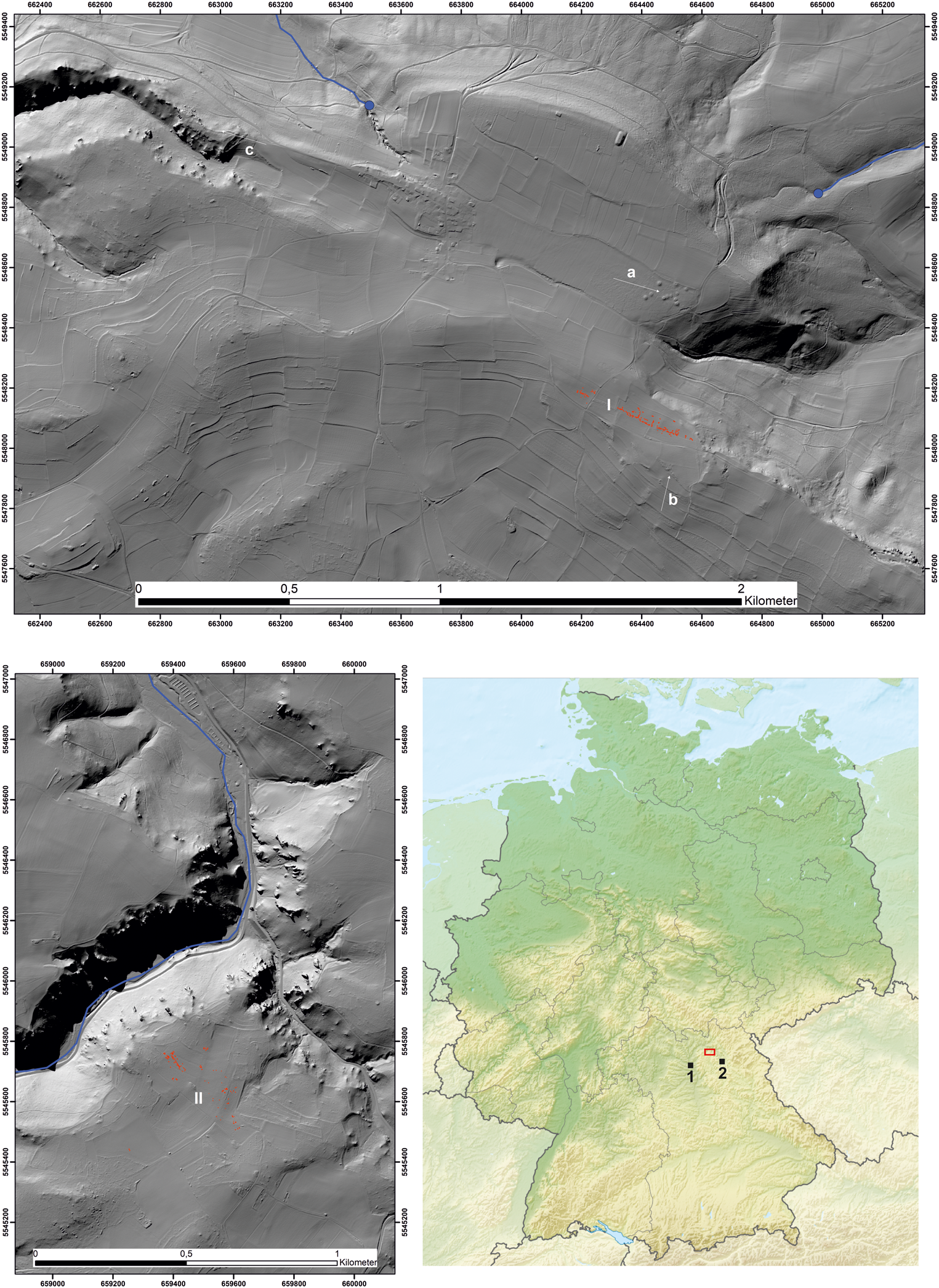
Figure 1. Top: LiDAR image of the Görauer Anger (I), with barrow fields (a–b) and the Kahlberg fortified hilltop settlement (c). Bottom left: LiDAR image of Weiden-Winkel (II). Blue circles: present-day springs; blue lines: streams (near Weiden-Winkel, the Weismain stream; in red: excavated areas (map: T. Seregély; source relief model DEM 1 m, Landesamt für Digitalisierung, Breitband und Vermessung, Munich). Bottom right: location map with study area marked in red and the cities of Bamberg (1) and Bayreuth (2) (https://commons.wikimedia.org/ CC BY-SA 3.0).
The site of Weiden-Winkel (Figure 1: II) is situated immediately south of the edge of a plateau that drops steeply into the Weismain valley. The difference in altitude between the plateau and the river Weismain, an important source of drinking water, is about 80 m, with a gradient of about fifty per cent, illustrating how difficult it is to access fresh water. The plateau is not flat in the area that was occupied; it is characterized by gentle slopes and depressions.
Materials and Methods
Following the excavation of small test areas in the first part of the project, larger trenches were opened during two field campaigns in 2020 and 2021, selected primarily on the basis of find concentrations and geophysical anomalies.
Magnetometry was carried out with a Bartington Grad601-2 fluxgate gradiometer and analysed with Geoplot (Geoscan Research). Numerous geological structures such as karst depressions and fissures hamper the interpretation of magnetic anomalies on the Jurassic plateaus. This is due to the conglomeration of ferromagnetic minerals resulting from their fill of Pleistocene solifluction clay and the reworking of loess. The minerals were formed by oxidation from e.g. siderite, ankerite, or ferroan dolomites (Ellwood et al., Reference Ellwood, Burkart, Rajeshwar, Darwin, Neeley and McCall1989). Some of these magnetic anomalies were cored with a handheld soil Edelman auger before excavation, to exclude geological causes.
Electrical Resistivity Tomography (ERT hereafter) was carried out with a Lippmann 4point light 10 W earth resistivity meter and varying profile lengths between 20 and 60 m, with electrode distances of 1 m. For the measurements, Wenner- and Dipole-Dipole arrays were used, the data were then combined (by Armin Rauen, in GeoTest Software) and analysed with Res2DInv/Res3DInv (Geotomo Software). At Weiden-Winkel, we also carried out measurements with up to twenty close-meshed profiles at 1 m spacing, using 3D inversion for data processing described by AGS Aarhus GeoSoftware (Lassen, Reference Lassen2020).
Ground penetrating radar was tested with a GSSI SIR 4000 control unit and 400 MHz antenna, but due to the clayey subsoil, data collection using this method did not yield any conclusive results.
Faunal remains were identified (by J. Zastrow, University of Tübingen) so species and age was determined when preservation was sufficient. However, the decalcification of the soil has led to an almost complete destruction of the bone structure, especially at Weiden-Winkel.
From the samples wet-sieved on site (if available, ten litres of sediment per archaeological feature), botanical macro-remains including charcoal were analysed as to their type. Charcoal fragments larger than 0.63 mm were identified using the microscopic wood anatomy atlas by Schweingruber (Reference Schweingruber1990). To facilitate identification, fresh breaks were created in transversal, tangential, and radial orientations. A stereo magnifying glass (Zeiss Stemi 508) and a microscope (Zeiss Axio Scope.A1) with a maximum magnification of 500× were used for identification.
When available, the remains of cereals or shorter-lived tree species were selected for 14C dating, rather than those of longer-lived species such as Quercus (oak), given the possible heartwood effect. For age determination of the samples, radiocarbon AMS dating was undertaken by Isotoptech Zrt. (Debrecen, Hungary; lab code DeA). Radiocarbon ages were calibrated using OxCal 4.4 based on IntCal20 (Reimer et al., Reference Reimer, Austin, Bard, Bayliss, Blackwell and Bronk Ramsey2020).
Samples for optically stimulated luminescence (OSL hereafter) analysis were collected during daytime using opaque steel cylinders. The equivalent dose (De) was measured using a single-aliquot regenerative-dose protocol (Murray & Wintle, Reference Murray and Wintle2000, Reference Murray and Wintle2003) on the coarse grain quartz fraction (90–200 μm). All measurements were carried out on Risø-Readers TL/DA-20 at the University of Giessen using blue light stimulation (470 ± 30 nm). To determine the radionuclide concentrations, a combined alpha- and beta-counting method was applied (μDose system; Tudyka et al., Reference Tudyka, Bluszcz, Poreba, Miłosz, Adamiec and Kolarczyk2020; Kolb et al., Reference Kolb, Tudyka, Kadereit, Lomax, Poręba and Zander2022). Dose rate samples were collected within a radius of 0.3 m around the OSL sample to account for inhomogeneous gamma dose rates in the surrounding sediment. Data analysis was undertaken with the R-package ‘Luminescence’ (Kreutzer et al., Reference Kreutzer, Schmidt, Fuchs, Dietze, Fischer and Fuchs2012, Reference Kreutzer, Burow, Dietze, Fuchs, Schmidt and Fischer2022). Dose rates and final luminescence ages were calculated with the Dose Rate and Age Calculator (DRAC v.1.2; Durcan et al., Reference Durcan, King and Duller2015), using the conversion factors of Guerin et al. (Reference Guérin, Mercier and Adamiec2011).
Results
Görauer Anger
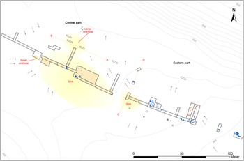
On the Görauer Anger, an area of 8000 m2 was investigated. The widely dispersed site is divided into three parts: an eastern sector with primary orientation to the north-west, a central part with primary orientation to the north-east, and a western one with primary orientation to the south-west (Figure 2; Supplementary Figure S1–3; all supplementary figures and tables prefixed with S hereafter). The preservation of features was moderate to good, especially in the eastern and central parts. Colluvial deposits of 0.05–0.5 m thick were encountered in two sinks and two sinkholes (detected by geophysics), which partially overlay former occupation layers and archaeological features. The smaller sinkhole was easily recognizable in the magnetometry survey as a circular anomaly with a diameter of six metres (Figure S8). The larger sinkhole, detected by ERT, with an oval shape of 27 × 20 m is oriented north-west to south-east. Two sinks could also be identified by ERT; the rather irregular sink, measuring approximately 24 × 18 m in the eastern part, could also represent a sinkhole (Figure S6a). The large, oval, elongated sink in the central part measuring 90 × 40 m is much shallower, and the colluvial deposit covered several Metal Age postholes and pits.
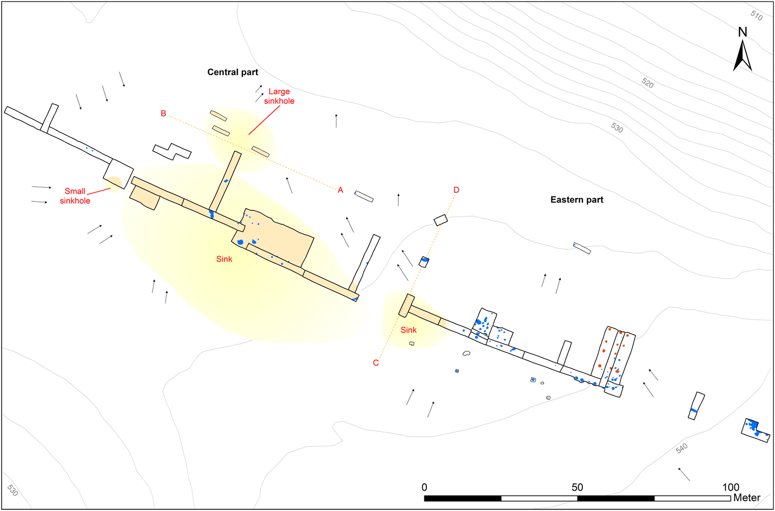
Figure 2. Plan of the Görauer Anger (excluding its western part). Blue: archaeological features; red: postholes of the Late Bronze Age house; yellow: sinkholes/sinks; orange: colluvial deposits in excavated areas; black arrows: current slope of the terrain; A–B and C–D: profile lines for ERT measurements (see Figure S6).
Some features, especially storage pits, contained large pottery fragments, which in most cases could only be roughly dated to the Late Bronze Age (1200–800 bc). Metal finds were absent, apart from a broken bronze needle shaft. Thus, the finer chronology of the occupation and land use phases could only be determined through an extensive 14C dating programme. The microliths collected during the field survey and present in more recent features indicate a first use of the site in the Mesolithic (9600–5500 bc), probably as a seasonal hunting camp. A first permanent settlement and land use phase could be identified from the later Neolithic onwards, for which, however, no in situ evidence was found. This is indicated by some typical sherds of the Michelsberg culture (4200–3500 bc; Figure 3a), in a colluvial deposit (dating from the late fifth to early third millennium bc; see Table S2: I (44)) in the shallow sink of the eastern sector. The older colluvial deposit below, dated to between the later sixth and later fifth millennium bc in the small sinkhole, can be considered as further evidence of later Neolithic activities.
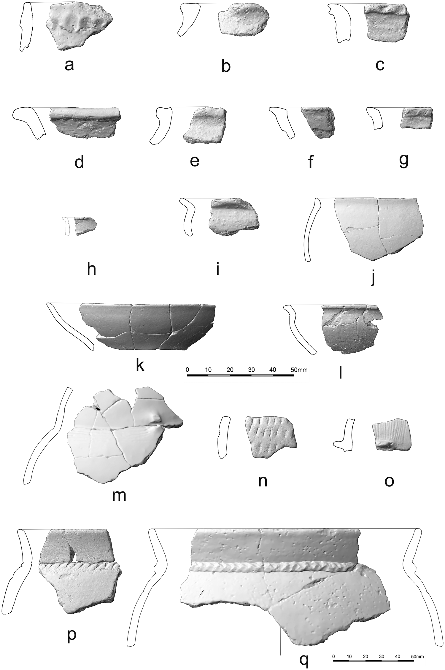
Figure 3. Ceramics from the Görauer Anger. a: Later Neolithic; b–g: Middle Bronze Age; h–q: Late Bronze Age (a–p: central scalebar; q: scale at bottom right).
For the mid-third millennium bc, evidence for the use of the site is scarce but clear, as attested by ceramics of the Corded Ware culture, including a characteristic lug of an amphora in an occupation layer in the strata of the small sinkhole. Furthermore, radiocarbon dates from colluvial deposits of both sinkholes and the depression in the eastern part of the settlement area support a Corded Ware occupation phase (Table S1: 21, 34, 39). The absolute dates also cover the transition to the Early Bronze Age and indicate continuity into the late seventeenth century bc. It is notable that the data from the late third and early second millennium bc all come from almost completely eroded postholes with depths between 0.08 and 0.24 m (Figure 4a; Table S1: 4, 19, 30, 40, 43–44), which did not contain any datable finds. These features are distributed over the entire settlement area.
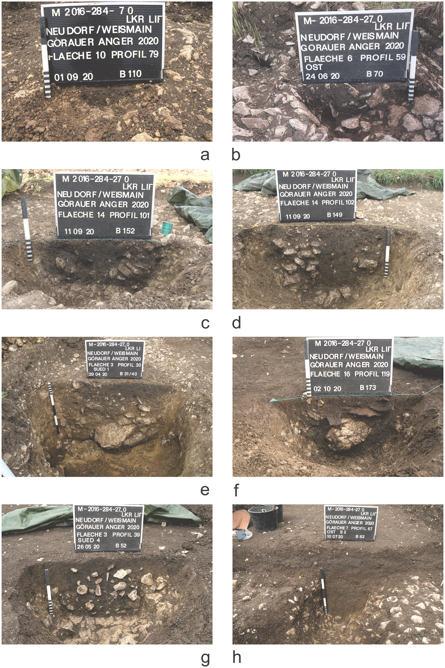
Figure 4. Sections of archaeological features from the Görauer Anger. a: Early Bronze Age posthole; b: Middle Bronze Age posthole; c–d: Late Bronze Age postholes; e: Late Bronze Age storage pit; f: Late Bronze Age pit; g: Iron Age pit; h: small ditch.
Poorly preserved postholes with depths of up to 0.18 m date to the fourteenth/thirteenth centuries bc (Figure 4b; Table S1: 37–38). Dates from colluvial deposits support the dating of this occupation phase (Table S2: II (80), III (91)), but only a few pottery sherds can be assigned to this phase (Figure 3b–g) and they were found almost exclusively in redeposited sediments. The best preservation is found in Late Bronze Age features, especially those of the Middle and Late Urnfield period. Numerous postholes with depths of up to 0.43 m, storage pits and other pits with depths of up to 0.80 m, and the backfill of a presumed sunken-floored building date between 1200 and 800 bc (Table S1: 1–3, 6–8, 10, 12–13, 15–18, 20, 22–24, 26–28, 31, 33, 36, 41, 46–50). Most of the pottery recovered from the features also date to this period (Figure 3h–q), including several fragments of a large storage vessel recovered in a small pit (Figure 4f). In the eastern part of the settlement area, a two-aisled, twelve-post building of about 12 × 6 m can probably be assigned to the later Urnfield period (1000–850 bc; Figure 2; Table S1: 12–13). In one case, the original post is still visible in section (Figure 4d).
Only three features, a pit containing occupation material (Figure 4g) and two post pits, yielded Iron Age dates (Table S1: 9, 25, 32), which are also indicated by the ceramics they contained. The long narrow pits or ditch-like structures, observed throughout the eastern and central area, are a type of feature that is difficult to assess due to the limited area that has been excavated. Some date to the Bronze Age, are oriented towards the large sinkhole, and could be drainage ditches (Figure 4h; Table S1: 35). Two others with an east–west orientation, as well as part of a linear stone substructure, yielded early medieval dates (seventh–ninth century ad; Table S1: 15, 29, 45), but without any significant finds that could indicate the kind of activity that took place at this time. A re-opening of the landscape through anthropogenic land use is, however, also indicated by the early medieval OSL age of the upper colluvial deposit of the large sinkhole (Table S2: II (79)).
Weiden-Winkel
The complex topography at Weiden-Winkel required a differentiated methodological approach to gain maximal information on chronology and feature preservation. Thus, 1000 m2 were investigated in the northern part of the site in several larger trenches, whereas small test excavations targeted the southern part (Figure 5; Figure S4). ERT measurements revealed two backfilled sinkholes measuring 15 × 15 m and 18 ×19 m respectively (Figure S6, c–d). The 3D inversions of ERT data of some smaller rectangular areas revealed some larger pit-like structures of irregular shape and size measuring between 2 and 8 m2 (Figure S7). These were filled with loess loam, with a slightly higher electrical resistivity than the surrounding terra fusca.

Figure 5. Plan of Weiden-Winkel (northern part only). Green: postholes; blue: pits; orange: presumed clay extraction pits; violet: presumed water harvesting pits; dark red: erosion channels; red: presumed tree-throws; yellow: sinkholes: E–F and G–H: profile lines for ERT measurements (see Figure S6).
As at the Görauer Anger, microliths indicate the first traces of human activity during the Mesolithic. Some irregular pits yielded Neolithic radiocarbon dates (Table S1: 18, 21, 23, 29), from samples taken from a very light-coloured backfill of loess loam but with no finds other than charcoal; their possible function is discussed below. They point to possible phases of use in the Middle Neolithic (4900–4400 bc), Late Neolithic (3500–3200 bc), and Final Neolithic to Early Bronze Age (2500–2000 bc). Knapped lithic artefacts (some fragmentary) also indicate Neolithic occupation. No clear settlement features like postholes or pottery typical of these periods were found.
The same applies to the Early and Middle Bronze Age, for which radiocarbon measurements of charcoals from the twenty-first to seventeenth and thirteenth centuries bc, respectively, are available from similar features (Table S1: 19, 23, 35, 37). A small, poorly preserved posthole only 0.16 m deep (Table S1: 10) returned a Middle Bronze Age date. Unlike on the Görauer Anger, the Late Bronze Age is documented by only a few clear settlement features, including two pits with occupation material, abundant pottery typical of the period (Figure 6b–g) and a posthole (Figure 7a and e). The latter belongs to a series of three, spaced 2.8 m apart, likely to belong to a north-west to south-east oriented house. Dates pertaining to the late Urnfield period (tenth–ninth centuries bc) are dominant, and two dates around 800 bc evidence a continuity of occupation into the Iron Age (Table S1: 2–4, 14, 24, 27).
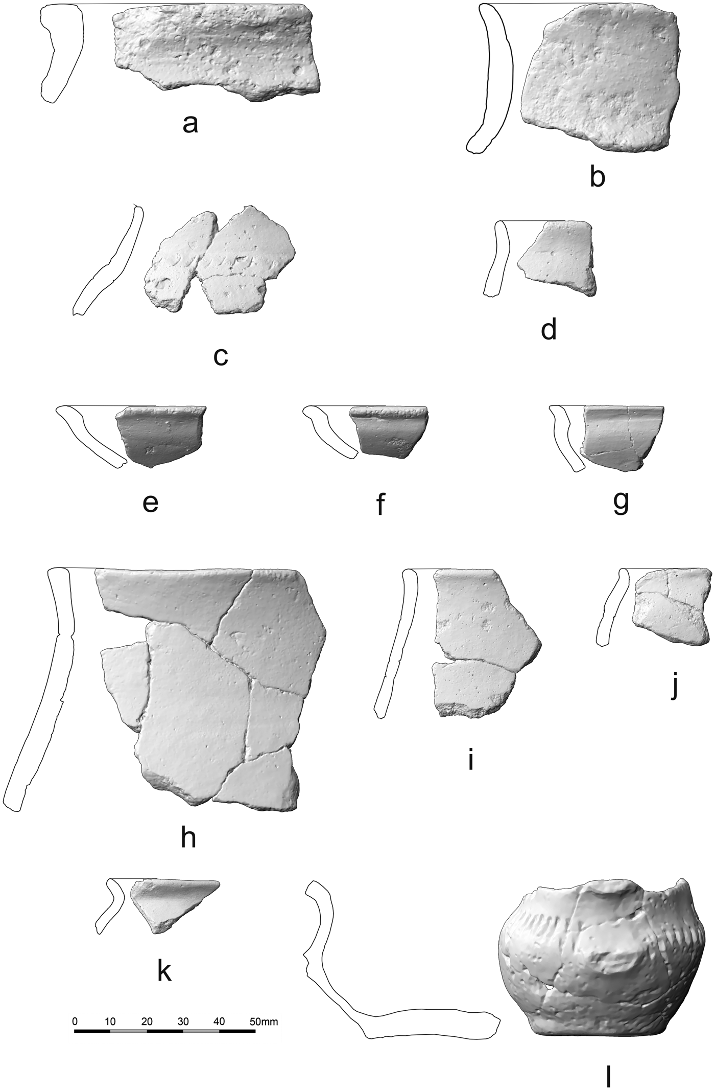
Figure 6. Ceramics from Weiden-Winkel. a: Middle Bronze Age; b–g Late Bronze Age; h–l Early Iron Age.
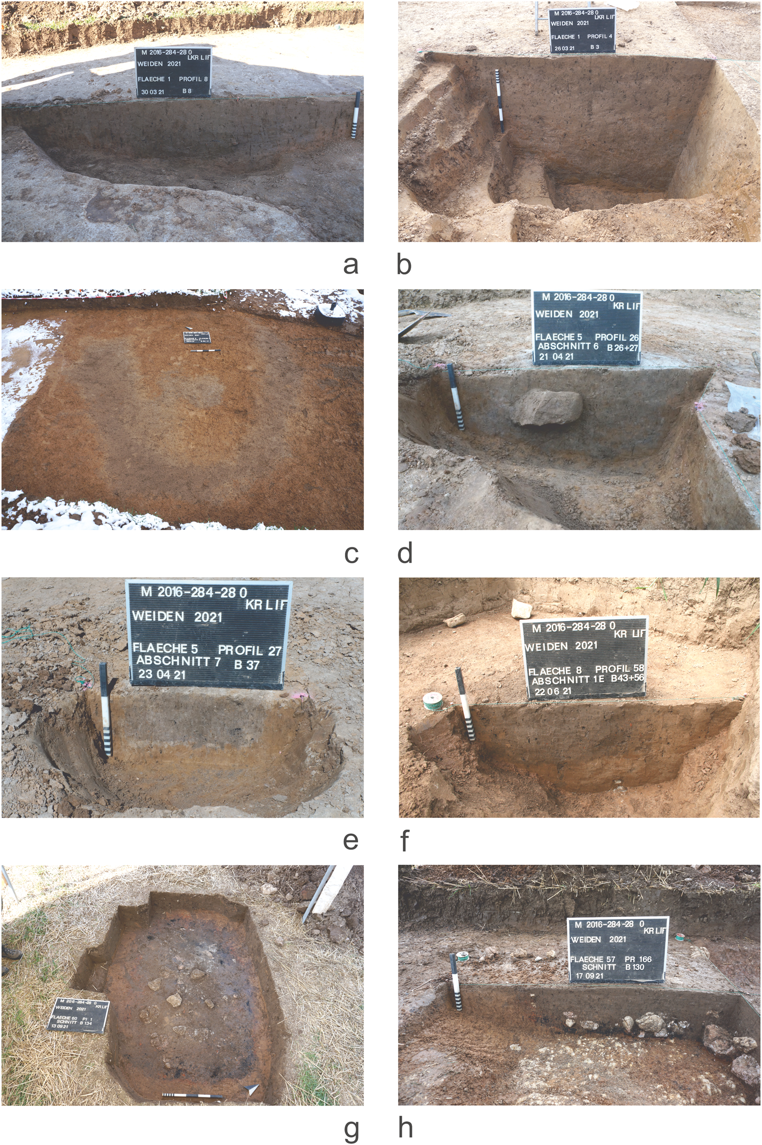
Figure 7. Sections and views in plan of features from Weiden-Winkel. a: Late Bronze Age pit; b: presumed water harvesting pit; c: presumed tree-throw; d: Iron Age pit; e: Late Bronze Age posthole; f: Iron Age posthole (left, dark brown) cutting a presumably Late Neolithic clay extraction pit (right; ochre); g–h: Iron Age cooking stone pit.
Most of the settlement features at Weiden-Winkel, including pits and postholes, date to the Iron Age (Hallstatt to Early La Tène period, c. 800–350 bc) (Figure 7d and f; Table S1: 5–7, 11–13, 15–16, 20, 28–29, 31–32, 41). As in the older periods, the preservation is poor, with pits and postholes reaching a maximum depth of 0.28 to 0.40 m. About 200–300 m south-east of the settlement area, the magnetometry survey identified anomalies arranged in rows. These turned out to be cooking stone pits of the Hallstatt period dated to between 800 and 500 bc (Figure 7g–h; Figure S9; Table S1: 34, 38, 42). Of the twenty-five pits identified by magnetometry, eleven were excavated either completely or partially (Figure S5). Despite varying states of preservation, they typically contain a charcoal layer with overlying stone packing, soil and stone material reddened by fire exposure, and very few finds (Honeck, Reference Honeck2009: 10–15; Beigel, Reference Beigel2019: 120–22; Schaefer-Di Maida, Reference Schaefer-Di Maida2022: 463–64). Their exact structures and finds (Figure 6h–l) will be presented in a future article.
Apart from one Roman period date (second–third century ad; Table S1: 22), evidence of activity increases in the Middle Ages (eighth–twelfth century ad; Table S1: 8, 17, 22, 25, 39). In two cases, the dates were obtained from horseshoe- or ring-shaped structures with diameters of about 3 to 3.5 m (Figure 7c), which we interpret as large tree-throws. The few modern dates (mainly charcoal from Pinus or Picea/Larix (pine, spruce, or larch)) come mainly from shallow colluvial deposits, which cover prehistoric features (Table S1: 9, 23, 30, 33, 36).
Discussion
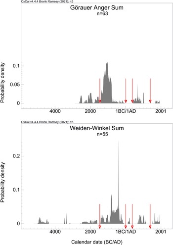
Our data—i.e. sixty-three radiocarbon dates from Görauer Anger, and fifty-five from Weiden-Winkel—indicate an unexpected temporal depth of occupation and land use at both settlement sites (Figure 8). For the older phases of use (Mesolithic to Middle Bronze Age), no or only very poorly preserved settlement structures were identified, attributable primarily to differences in the construction of buildings (dwellings, granaries, etc.), waste disposal and storage, and to the erosion of former occupation surfaces present in prehistoric times and continuing into the modern era. In northern Bavaria there is a lack of clear evidence of typical post-built structures from the Late Neolithic to the Final Neolithic, unlike in other periods, such as the Early Neolithic or the Late Bronze and Iron Ages. On the other hand, there are isolated indications of pit dwellings and log or sill beam constructions with a slightly deepened interior, i.e. sunken-floored buildings (Seregély, Reference Seregély2008: 32–38; Link, Reference Link, Pechtl, Link and Husty2016).

Figure 8. Calibration of all 14C dates (Görauer Anger n = 63, Weiden-Winkel n = 55). Some gaps at both sites coincide: the transition from the Early to the Middle Bronze Age around 1600/1500 bc, the later La Tène period until the beginning of the early Middle Ages, and the late medieval period of desertion.
Evidence for clearly sunken-floored structures is also missing from our region in the Early and Middle Bronze Ages; for the latter, there are only sparse indications of slightly deepened postholes or pits, as well as an apparently targeted waste disposal into a palaeo-channel that probably dried up at that time (Seregély, Reference Seregély and für Denkmalpflege2013). For the entire period from the Late Neolithic to the Middle Bronze Age, there are also no deep storage or waste pits in the region, unlike in more recent periods, when they are frequently encountered. From the Late Neolithic onwards, increased livestock farming and the associated change in land use probably led to changes in house construction and waste disposal (Kalis, Reference Kalis and Karlsruhe2010: 42–43), although regional aspects and increased mobility also played a role (Müller & Seregély, Reference Müller, Seregély, Müller and Seregély2008: 181–86). From the Late Bronze Age onwards, there was an intensification in cereal cultivation (e.g. expansion and ploughing of arable land on slopes, cultivation of pulses, crop rotation, manuring) as well as the introduction of new crops such as millet and broad beans (Vicia faba), and thus changes in stockholding (Kneisel et al., Reference Kneisel, Dal Corso, Kirleis, Taylor, Tiedtke, Kneisel, Corso, Kirleis, Scholz, Taylor and Tiedtke2015; Filipovic et al., Reference Filipovic, Meadows, Wiethold, Jahns, Bittmann and Kirleis2018; Tserendorj et al., Reference Tserendorj, Marinova, Lechterbeck, Behling, Wick and Fischer2021; Rösch, Reference Rösch, Miera, Knopf, Scholten and Kühn2023: 40).
The lack of features, finds, and radiocarbon determinations mark a hiatus in the transition period from the Early to the Middle Bronze Age, around 1600/1500 bc (Figure 8), a time in which breaks in occupation and changes in settlement patterns are known at a supra-regional level (Kneisel et al., Reference Kneisel, Kirleis, Dal Corso, Taylor and Tiedtke2012: 269–73). A combination of social and economic factors led to a kind of collapse in Early Bronze Age societies in many European regions (Kneisel, Reference Kneisel, Kneisel, Kirleis, Dal Corso, Taylor and Tiedtke2012: 274–77; Müller, Reference Müller, Meller, Bertemes, Bork and Risch2013: 533–36). In the northern Bavarian region considered here, the number of sites then increases again from the middle of the fifteenth century bc (Berger, Reference Berger1984), and, around 1300 bc, a shift in the settlement pattern from valley locations to the Alb plateaus occurs, apparently due to a deterioration in climatic conditions (Seregély, Reference Seregély and für Denkmalpflege2013; Breitenbach et al., Reference Breitenbach, Plessen, Waltgenbach, Tjallingii, Leonhardt and Jochum2019; Kothieringer et al., Reference Kothieringer, Seregély, Jansen, Steup, Schäfer, Lambers and Fuchs2023).
Some irregularly shaped pits found at the site of Weiden-Winkel were probably used for clay extraction and quickly backfilled afterwards. All but one of the Neolithic dates are from this type of feature, although some also yield more recent dates. Some of the larger pit structures of irregular shape and containing few finds show clear signs of waterlogging (Figure 7b), with a faded, grey sub-horizon with rusty brown spots. The backfill of these structures, which are usually much deeper than the supposed clay extraction pits (between 0.65 and 1.2 m), consisted of a grey-brown, charcoal-rich loess with occasional prehistoric sherds. All charcoal dates are prehistoric; in one feature (Figure 7b) we could prove a stratigraphic sequence with dates from the Final Neolithic to the Iron Age (Table S1: 1). This suggests longer periods of backfilling and deliberately keeping these pit-like structures open, as also supported by the OSL evidence (Table S2: I (3)). We assume that they were used for rainwater harvesting, although it remains unclear whether the pits were originally small sinkholes or deliberately dug. The use of cistern-like pits, locally known as Hülen, is typical of the Franconian karst plateaus in medieval times (Dürer et al., Reference Dürer, Rapp and Rebhan1995). The water was used mainly for watering livestock and activities such as washing or firefighting.
There are other differences between Weiden-Winkel and Görauer Anger. Apart from the presence of the various pit types at Weiden-Winkel, absent at Görauer Anger, differences in the temporal focus of the prehistoric features are notable. While the majority of the Görauer Anger features date to the Late Bronze Age, the excavation at Weiden-Winkel primarily recorded Iron Age features (Figure 8). But we should not read too much into this, given that we only investigated small portions of a very extensive settlement. At the Görauer Anger, the two Iron Age features in the eastern and central parts of the site are located on the south-western edge of the investigated areas. We assume a shift in occupation to the south-west from the eighth century bc onwards.
In contrast, at Weiden-Winkel, the focus of the Late Bronze Age settlement was more likely to have lain upslope to the south-west of the survey areas. Approximately 300 m to the west from the excavated settlement area, a shallow colluvial deposit on the adjacent upland plateau was also dated to the Late Bronze Age, which can be interpreted as an indicator of agricultural land use (Table S1: 43). The colour of the deposits filling the features further distinguishes the two settlement sites (Figures 4 and 7). At Weiden-Winkel it is lighter grey, brown, or ochre, at the Görauer Anger it is darker brown. In our opinion, this is not due to different anthropogenic use, but might instead be explained by an interaction between the local topography and pedological phenomena. This relief-related situation apparently led to a significantly higher loess accumulation at Weiden-Winkel than on the ridge of the Görauer Anger during the last cold period of the Pleistocene. Thus, at the latter site, a medium-deep cambisol developed from the mixture of loess drifts of older glacial cold phases, sandy remains of the Cretaceous and Tertiary clay soils (Garleff & Krisl, Reference Garleff and Krisl1997). The higher clay content may have better preserved the organic matter, leading to a darker sediment (Kahle et al., Reference Kahle, Kleber and Jahn2003; Amelung et al., Reference Amelung, Blume, Fleige, Horn, Kandeler and Kögel-Knabner2018). In Weiden-Winkel, on the other hand, so-called parabrown soils (sols lessivés) developed from loess, which, in the absence of vegetation, tend to soil erosion (and thus, in this case, the leaching of nutrients and humic substances).
The poor state of preservation of the sites means that evidence of diet and husbandry is very limited. The strong decalcification of the soil resulted in poorly preserved animal bones. Only a few bones and some teeth of cattle (142 g), pig (67 g), sheep/goat (37 g), and dog (7 g) could be recovered in some, mostly Late Bronze Age, features on the Görauer Anger. A similar bone spectrum is also found in a single Urnfield-period storage pit (Kothieringer et al., Reference Kothieringer, Seregély, Jansen, Steup, Schäfer, Lambers and Fuchs2023: 16). The even rarer bones of wild animals come from red or roe deer (19 g) and brown hare (1 g). In Weiden-Winkel, only a few very poorly preserved deer bones (29 g) come from the fills of two Iron Age cooking stone pits.
The botanical macro-remains are similarly poorly preserved. Many more finds from the Görauer Anger could be assigned to a precise species (31 Hordeum (barley), 27 Triticum dicoccum (emmer wheat), 24 Triticum durum/aestivum (wheat), 15 Panicum (millet)) than at Weiden-Winkel (10 Hordeum) because in Görau, unlike Weiden, we excavated several storage pits. A more precise assignment of the faunal and archaeobotanical evidence to individual settlement phases, and thus differentiation, is barely possible, given the long, persistent occupation span and the low number of determinable specimens. Similarly, the charcoal samples analysed only allow us to recognize chronological changes with the help of the dated samples. Thus, all dated Ulmus (elm) samples belong to the Neolithic period, and Quercus (oak) and Fagus (beech) do not show significant fluctuations from the Neolithic to the Iron Age. In contrast, evidence from the first post-Christian centuries mainly comes from Fagus and, in Weiden-Winkel, also from Fraxinus (ash), while Quercus is sparse. Maloideae (apple subfamily) is represented in the spectrum only from the Middle Bronze Age onwards, Carpinus (hornbeam) only from the Late Bronze Age onwards. Pinus occurs rarely in Görau, but regularly in prehistoric contexts, while in Weiden-Winkel Pinus (together with Picea/Larix) yielded almost exclusively modern dates. The dominance of Quercus (for Görauer Anger approximately 54 per cent and for Weiden-Winkel approximately 36 per cent) is clear in both settlement areas and is complemented in Weiden-Winkel by a higher proportion of other deciduous tree species such as Betula (birch), Fraxinus, Acer (maple), Corylus (hazel), and Carpinus (Table S3). Overall, the charcoal reflects the species composition of the forest on the plateau and nearby slopes. Mixed deciduous forests with high proportions of Quercus and Fagus were typical in the study area; Betula and Fraxinus are indicative of landscape opening, and thus settlement and land use.
With regard to connections between the rural settlements and surrounding sites, the fortified hilltop settlement on the Kahlberg (Figure 1, Ic), visible to the north-west of the Görauer Anger, and the burial mounds to the north (Figure 1, Ia), among the largest in northern Bavaria, stand out. Social differences and dependent relationships cannot be ruled out but are difficult to prove, despite the find of a Middle Bronze Age bronze dagger from the Kahlberg and the rich furnishings of the primary burials of the barrow field. Nevertheless, a connection seems plausible, whereby the rural settlement had a supply and lookout function with a clear view towards the Main valley, and the fortified settlement a protective function as a refugium, centre of metal craftsmanship, and/or control over a trade route.
In Weiden-Winkel, no such evidence of a fortified settlement is currently discernible. There, features that could potentially be burial mounds have been mapped in the immediate vicinity, but there are no indications of finds from previous excavations or reliable evidence as to whether they were funerary structures.
Conclusion
Through a combined archaeological and geoarchaeological research approach, it has been possible, for the first time in our study area in north-eastern Franconia, to document the existence of a long-lasting, mostly continuous rural occupation and land use in a European low mountain zone that is often described as peripheral and unfavourable for settlement. The first traces of occupation or settlement activity, with interventions in the landscape, are attested as early as the fifth/fourth millennium bc; such interventions are likely to have led to more intensive clearing and land use in the course of the third and early second millennium bc. After a hiatus in occupation around 1600/1500 bc, perhaps caused by a supra-regional collapse of Bronze Age social and economic systems, renewed occupation of the Jurassic plateaus began about two centuries later, during the later Middle Bronze Age. It resulted in a significant transformation of the landscape through a continuity of intensive settlement and land use that lasted about a millennium. This led to an almost total erosion of earlier features, especially of the Neolithic to Middle Bronze Age. After another break in settlement, which probably took place as early as the fourth century bc, but at the latest in the third century bc, a reforestation of this low mountain region is likely to have taken place. It was not until the early Middle Ages that several radiocarbon dates and a colluvial deposit show increased land use again, which, although interrupted by a period of desertion in the late Middle Ages, continued until the present.
Our results illustrate that the concept of favourable and unfavourable areas, frequently discussed in recent times, is not necessarily applicable to prehistoric periods (James et al., Reference James, Teuber, Miera, Downey, Henkner and Knopf2021; Miera et al., Reference Miera, Knopf, Scholten and Kühn2022). It remains undisputed that low mountain regions were affected by significant locational disadvantages, particularly in terms of water supply, climatic conditions, and communication networks. The reasons, be they climatological, ecological, economic, or social, for putting up with such disadvantages or for searching for solutions to overcome them may have varied regionally and through time, and will require more consistent research input. It is highly unlikely that the northern Franconian Jura was an isolated instance of such circumstances. It is hoped that, in the future, evidence of long-lived prehistoric rural settlement will emerge from other European low mountain regions, enabling further comparative studies.
Acknowledgements
This research was funded by the German Research Foundation (project no. 282541074) and the Oberfrankenstiftung. We thank all students for fieldwork and laboratory work, Isotoptech Zrt. Debrecen for the 14C analyses, Britta Ziegler (University of Bamberg) and Armin Rauen (Geophysik, Wallerfing) for support concerning the ERT measurements.
Supplementary Material
To view supplementary material, please visit https://doi.org/10.1017/eaa.2024.2.


 Open access