
On March 2, 1942, just four months after the attack on Pearl Harbor, Lt. Col. James H. “Jimmy” Doolittle assembled 80 US Army Air Forces (USAAF) airmen at Eglin Airfield on the Florida Panhandle to prepare for Special Aviation Project #1 – the Doolittle Tokyo Raid – that would strike the heart of the Japanese empire. Eglin, a secluded base on the Gulf of Mexico, provided an ideal location to train. There, to prepare for the secret April 1942 mission, 16 B–25 Mitchell bomber crews rehearsed short-field takeoffs that replicated an aircraft carrier’s truncated 450-foot runway, practiced navigation over open water, simulated evasive actions, and perfected low-level bombing techniques.Footnote 1
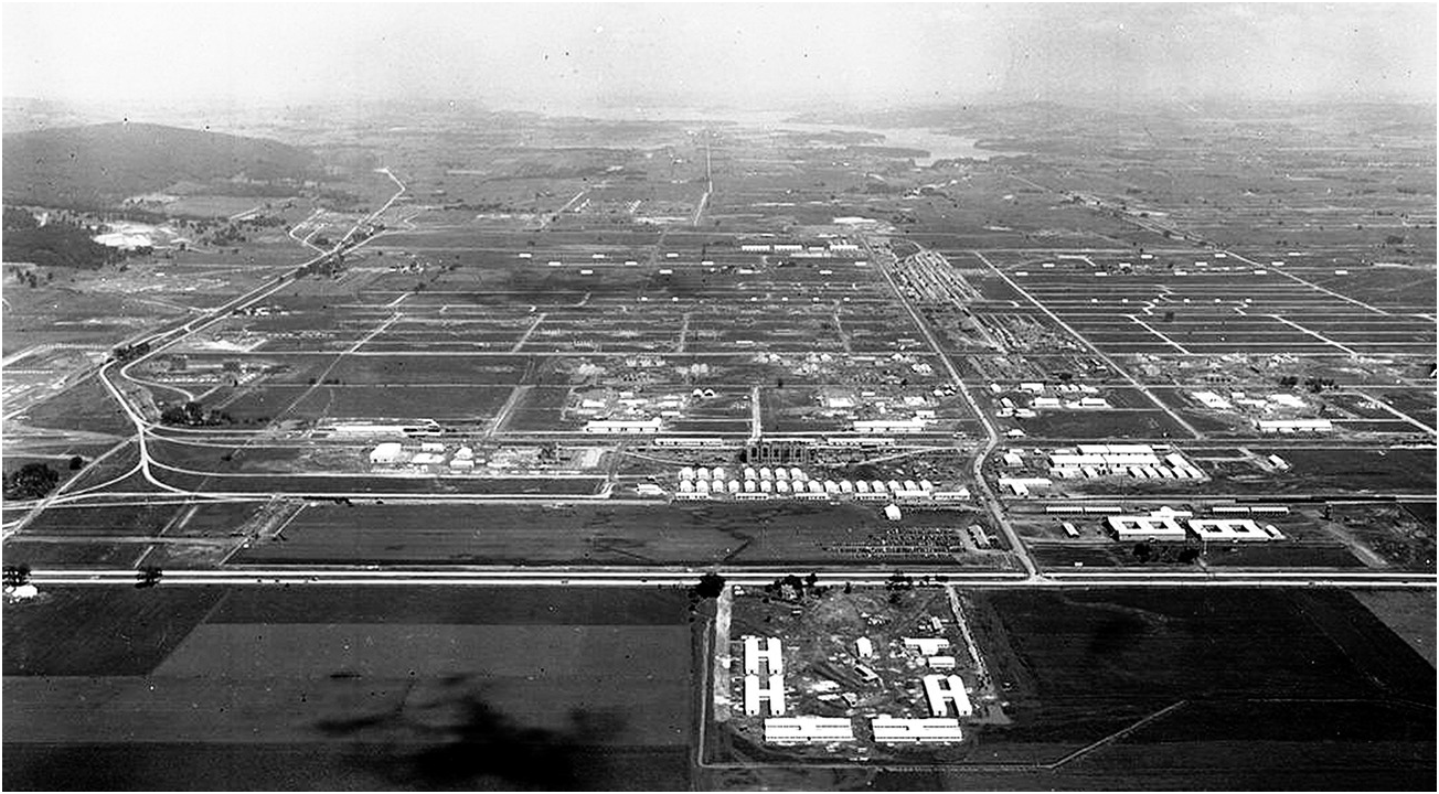
Eglin Airfield proved a tremendous asset for the daring Doolittle Raid and, throughout the war, provided an excellent testing area for the B-17 Flying Fortress, the B-29 Superfortress, and the US version of the German V-1 missile, the JB-2 Loon (see Figure 2.1). Today, Eglin is the largest US Air Force installation in the world, comprised of 725 square miles of land – more than half the size of Rhode Island – as well as 125,000 square miles of water.Footnote 2

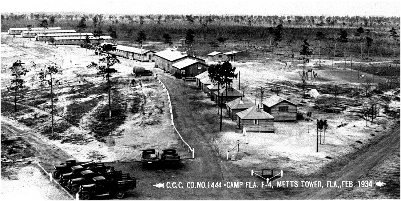
Like the majority of modern Department of Defense (DOD) installations that had their origins in World War II, Eglin grew from a marginal military facility to an established base during the war. It had possessed a mere 1,500-acre landing strip in 1937, but in October 1940 the US Forest Service (USFS) ceded nearly 400,000 acres – 625 square miles – of the Choctawhatchee National Forest to the US Department of War, which radically enlarged Eglin (see Map 2.1). President Theodore Roosevelt had originally designated the Choctawhatchee National Forest in November 1908, and the USFS began restoring cutover longleaf pine stands and protecting naval stores (see Figure 2.2). In May 1933, Camp F-3, Company 1402 of the Civilian Conservation Corps (CCC) established a camp in the forest near Niceville, employing 225 enrollees to construct fire lookout towers, improve timber stands, and build roads and recreational facilities (see Figure 2.3). After the War Department assumed control of the forest in 1940, a new CCC unit helped build runways and other structures at Eglin. In July 1942, the CCC transferred the camp to the USAAF. While the Forest Service had cursed the Choctawhatchee because of its low timber yields, military officers recognized the forest’s assets. The tract was big, unpopulated, isolated, and cheap; moreover, it boasted splendid weather, flat contours, and provided unimpeded access to infinite water ranges over which to train – attributes of an ideal proving ground.Footnote 3
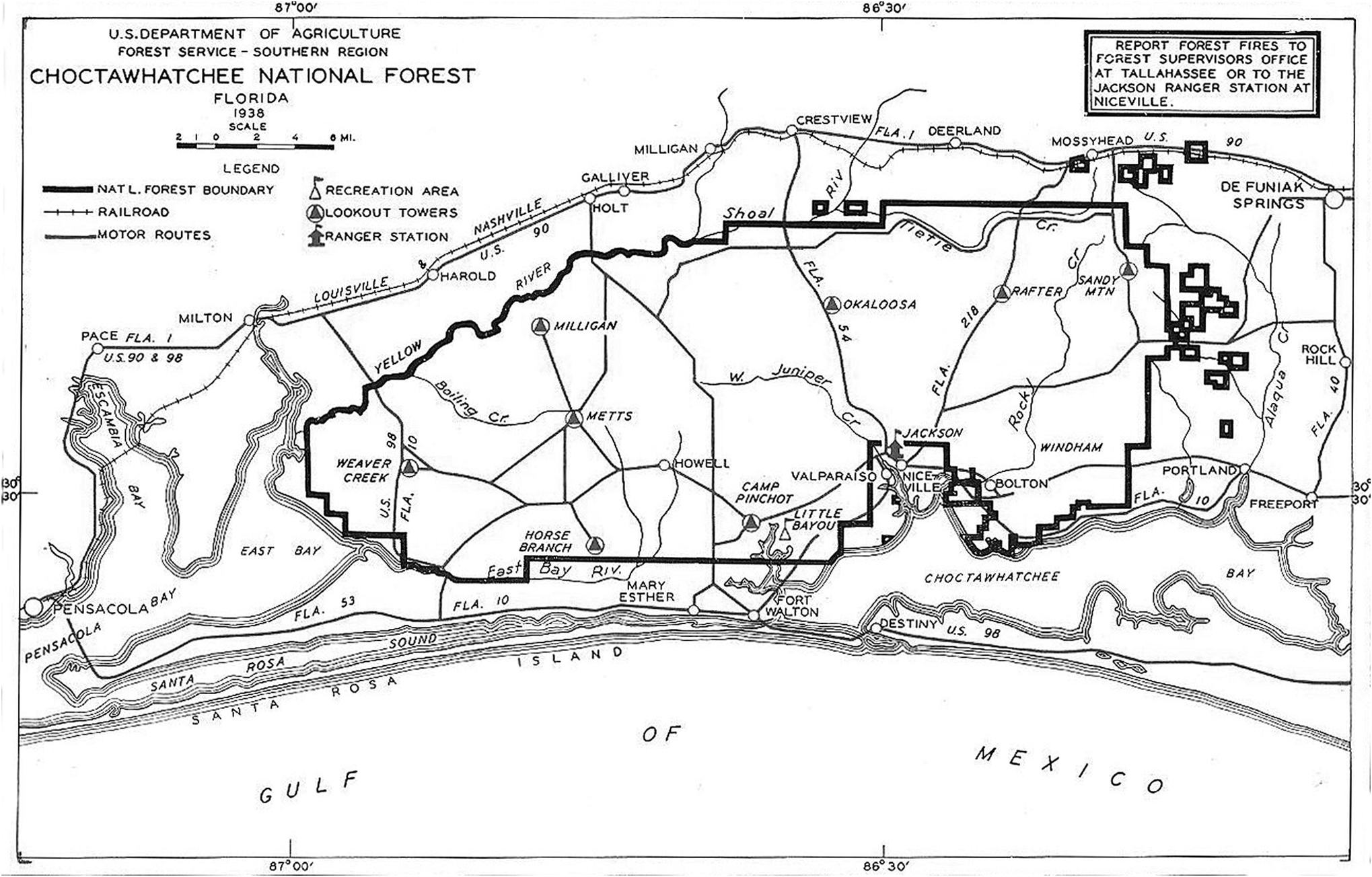

Figure 2.2 Naval stores operation in West Florida during the 1920s. The turpentine is being extracted from an old growth longleaf pine stand in what used to be Choctawhatchee National Forest, now Eglin AFB, in Walton or Okaloosa County, 1922.
Overview
Eglin was only one of thousands of military facilities that sprang up across the country as the United States mobilized for World War II. This chapter explains several fundamental reasons why the US Departments of War (Army and Army Air Forces) and Navy (Navy and Marine Corps) expanded exponentially to fight this war. The chapter also enumerates and describes the types of property required for different military training and production purposes; describes where and how the military obtained the acreage; and discusses the long-term environmental consequences of the military’s stewardship of this land.
Historically, Americans have held an ingrained aversion to maintaining a large standing army. As a result, the size of the US military has fluctuated according to the nature and magnitude of the threat to the nation’s security. Until technology reduced the distance that insulated the United States from international conflicts, American military forces were organized around a small professional nucleus that expanded – in numbers of personnel and in the extent of property holdings – during times of war. After World War I, the national desire for peace, and later the Great Depression, hindered military development politically and financially, but imminent threat of war in 1939 demanded that the United States begin preparing to fight.Footnote 4
In the years preceding and during World War II, as technological advances expanded the reach of military forces and implements of war, the US military required sizeable areas of land to prepare for battle. New weapons delivered increased speed, agility, and range, and to train effectively with them, defense agencies required tremendous amounts of acreage. In addition, these arms altered strategies and tactics, with larger, combined-arms military formations requiring unparalleled numbers of recruits who needed vast expanses on which to maneuver.
One of the first steps toward US military readiness included acquiring a substantial amount of land on which to billet and train its troops. Opportunely, an abundance of inexpensive public domain property in the Depression-era United States enabled the military to mobilize without delay and with minimum investment. In the 150 years leading up to World War II, the US military had accumulated approximately 2.6 million acres. Between 1939 and 1945, it procured 20 times that total, more than 52 million acres of land, a collective area larger than the state of Kansas. Much, although not all, of it stayed in the military’s hands for most of the Cold War period. More than half of the land that the defense establishment leased or purchased during the conflict was located in the southern third of the country, the region known today as the Sunbelt. Indeed, just as the availability of land shaped the early growth and development of the nation, it proved a critical component of America’s arsenal during World War II.Footnote 5
Initially, the military’s acquisition of property abruptly altered prevailing land uses: it converted grazing districts into bombing ranges, cornfields to ordnance works, apple orchards to plutonium reactors, marshlands to docking facilities, and coastal national parks to aircraft warning stations. This wartime activity spurred sustained, intensive use and often generated significant environmental contamination ranging from fuels and cleaning solvents to heavy metals, unexploded ordnance, and low-level radioactive waste. Ensuing Cold War‒era training exercises, weapons testing, and military hardware maintenance – and the great influx of people working on the bases – further fouled and otherwise damaged nearby ecosystems. The advent of enhanced environmental standards in the 1960s and 1970s forced DOD to begin remediation of past contamination and to alter its ecosystem management practices. Because a large proportion of installations still in the military inventory in the 2010s originated during World War II, the continued military land stewardship activities over the intervening 70 years have generated long-lasting, though not always permanent, environmental legacies.Footnote 6 In some instances, as discussed at the end of this chapter, the result is a paradoxically positive long-term effect of the military’s World War II land procurement the creation of large, sanctuary-like habitats that are protected from human encroachment.
Modern Warfare and the Demand for Land
In March 1938, after Germany annexed Austria, the United States awakened to the likelihood of a second world war. A year later, Germany seized Czechoslovakia, and in September 1939 it invaded Poland. Despite widespread isolationist sentiment in the United States, President Franklin D. Roosevelt heeded his advisors’ dire warnings and launched preparedness efforts. Spurred by continued German aggression in Europe and the fall of France in June 1940, Congress approved large military mobilization appropriations and granted preparedness powers, 18 months before the Japanese attack on Pearl Harbor.
The astonishingly rapid German victories demonstrated how developments in weapons technology, doctrine, and organizational structure during the interwar period had fundamentally transformed all levels of modern warfare. Combined with significant increases in troop numbers, these innovations required a massive quantity of arms and more extensive training facilities. This unprecedented expansion of training and production in the United States compelled the acquisition of sizeable areas of land, with inevitable environmental consequences. During World War I, the Allied and Central Powers had deadlocked on the Western Front for four years. Until late in the war neither side could break the stalemate created by trenches, barbed wire, massive amounts of artillery, and machine guns. This war of attrition ended only when the Allies, fortified by the arrival of US forces and tanks, outlasted German manpower reserves in the autumn of 1918. Two decades later, in 1939 and 1940, the German military dismantled that relatively static model of warfare by deploying mechanized formations to quickly penetrate opposing armies and to exploit their rear areas, throwing them into confusion. Further, the Japanese attack on Pearl Harbor, made possible by a modern carrier fleet, meant the United States would have to fight a two-ocean, truly global war – at sea, in the air, and on the ground.
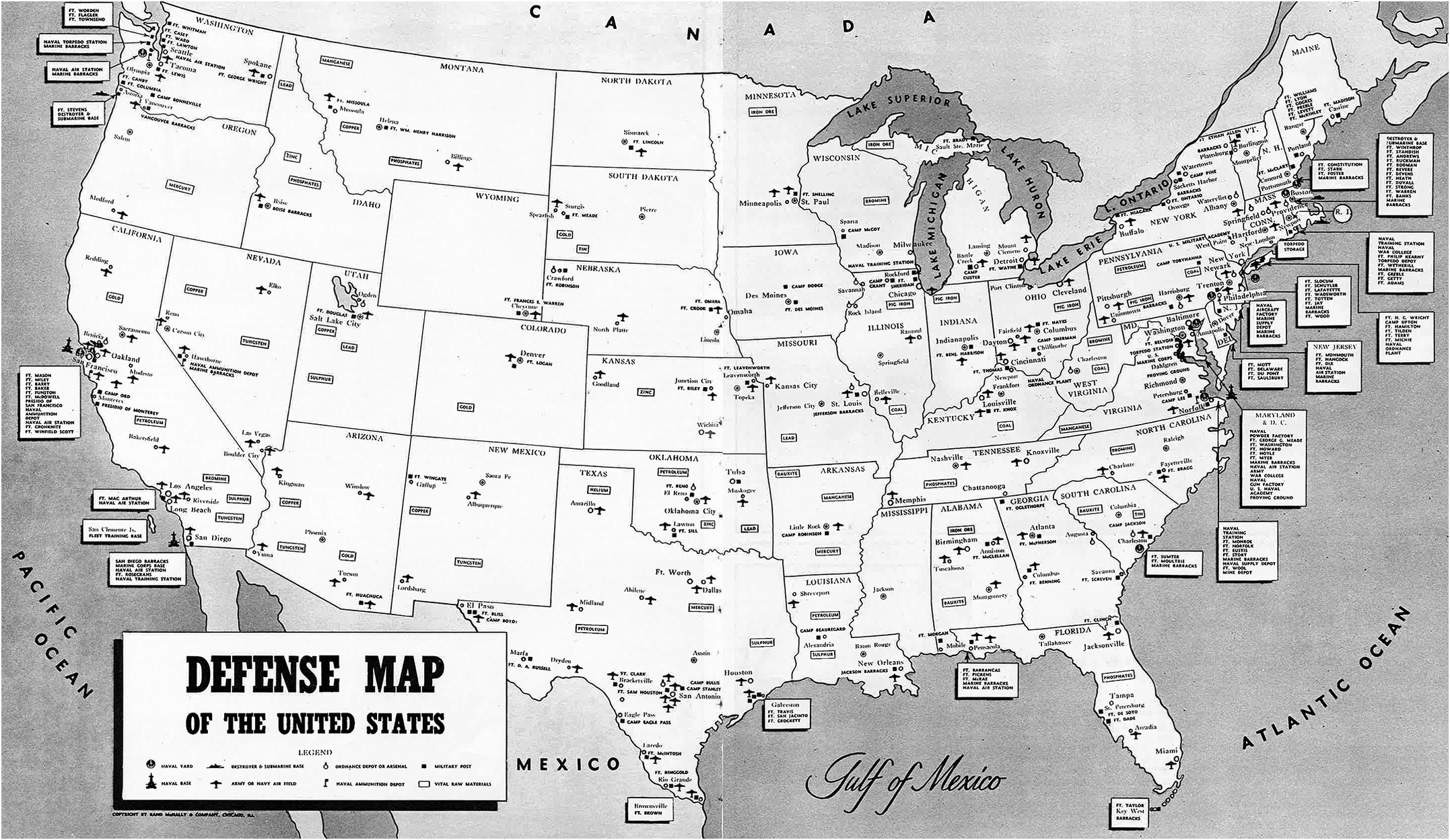
In response to the Axis onslaught, the US military armed and trained its forces for a new form of mechanized warfare that involved large interservice formations of specialized troops using weapons notable for increased speed, mobility, and firepower. These weapons platforms included faster, more agile tanks, artillery, antitank guns, and antiaircraft armament; larger, heavier, metalized aircraft with sophisticated navigational technology; larger radar-equipped ships and aircraft carriers; and innovative amphibious vehicles. Troops training on each of these systems needed significantly more space than those using earlier generations of weapons. Advances in vehicle mechanization and motorization required substantially greater maneuver area to conduct exercises; long-range artillery and modern antiaircraft guns demanded extended target ranges; and innovative amphibious vehicles necessitated development of new coastal training grounds. Furthermore, the United States had to develop its armories and war industries, which obliged US manufacturers to retool and expand. New technologies, tactics, and strategies compelled the war and navy departments to enlarge existing encampments and construct new training facilities, airfields, and bombing and artillery ranges, in addition to ordnance plants and depots, aircraft, tank, landing craft factories, and shipyards, all of which claimed substantial amounts of land (see Map 2.2).Footnote 7
During World War I, the US Army did not need extensive training areas for its troop formations. Division-sized units in that conflict occupied a much smaller frontage than their World War II counterparts. Furthermore, in the earlier conflict US forces prepared for combat behind the protection of a stabilized front in France, with American service members receiving limited training stateside before they embarked for Europe. This arrangement permitted the army to use temporary cantonments for housing troops because men quickly shipped out to France. In contrast, German conquest of much of Europe in the early stages of World War II dictated that before they arrived in Europe for battle, US Army formations had to be fully prepared to fight as coherent, large, combined-arms forces.Footnote 8 In response, the military expanded its bases and built thousands of new housing, recreational, medical, and educational structures that would last the war’s duration and in many cases well beyond.Footnote 9
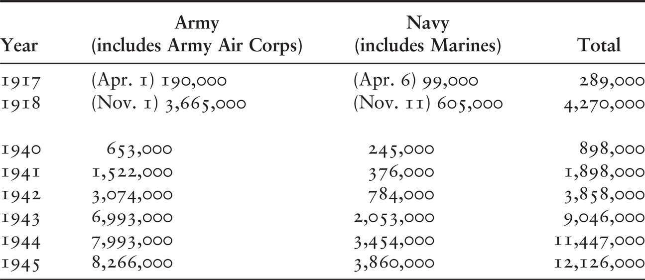
These facilities also had to accommodate dramatic increases in the number of troops that began entering the armed forces soon after Congress mobilized the National Guard and created the first peacetime draft in September 1940. Approximately 4.7 million American soldiers, sailors, airmen, and Marines served during World War I; nearly four times as many (16.1 million) served in World War II, with greatly increasing numbers entering the military as the war continued (see Table 2.1). Because of the global nature of the conflict, the American military also needed training grounds to prepare to fight in all types of terrain – jungles, deserts, mountains, oceans, shores – and climates – tropical, arid, polar, and temperate.Footnote 10
| Year | Army (includes Army Air Corps) | Navy (includes Marines) | Total |
|---|---|---|---|
| 1917 | (Apr. 1) 190,000 | (Apr. 6) 99,000 | 289,000 |
| 1918 | (Nov. 1) 3,665,000 | (Nov. 11) 605,000 | 4,270,000 |
| 1940 | 653,000 | 245,000 | 898,000 |
| 1941 | 1,522,000 | 376,000 | 1,898,000 |
| 1942 | 3,074,000 | 784,000 | 3,858,000 |
| 1943 | 6,993,000 | 2,053,000 | 9,046,000 |
| 1944 | 7,993,000 | 3,454,000 | 11,447,000 |
| 1945 | 8,266,000 | 3,860,000 | 12,126,000 |
Military mobilization for World War II demanded rapid new construction. Before the United States could produce guns, planes, and tanks, it had to assemble defense plants; before it could send troops into battle, it had to provide proper living areas and training grounds for new inductees. None of this development, however, could begin without land on which to build.Footnote 11 Thus, the availability in 1940 of contiguous stretches of sparsely populated public domain land in western states and submarginal agricultural and forest land in southern states was a windfall for the military. If defense agencies had been compelled to buy all the lands temporarily needed for prosecution of the war, the expenditure would have been prohibitive and time would have been lost.Footnote 12
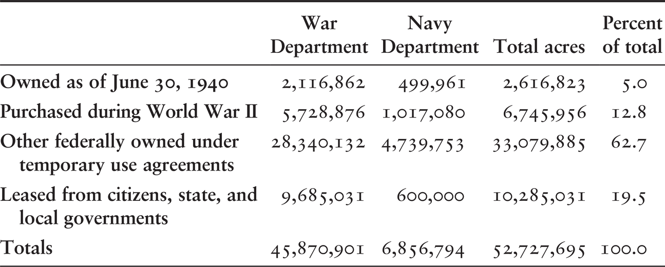
The land acquisition task that fell to the Army Quartermaster Corps’ Real Estate Branch was unprecedented. On June 30, 1940, the War Department occupied 2.1 million acres of land, while the Navy Department possessed an additional 500,000 acres. In 1940 alone, the military required eight million more acres, 14 times the roughly 571,000 acres the military acquired during World War I.Footnote 13 Over the course of World War II, the two military departments purchased roughly 6.7 million acres from private owners, leased 10.3 million acres from individuals and state and local governments, and used 33.1 million acres of public domain and other federal lands (see Table 2.2).Footnote 14
Table 2.2 Ownership status of land used by US Military during World War II
| War Department | Navy Department | Total acres | Percent of total | |
|---|---|---|---|---|
| Owned as of June 30, 1940 | 2,116,862 | 499,961 | 2,616,823 | 5.0 |
| Purchased during World War II | 5,728,876 | 1,017,080 | 6,745,956 | 12.8 |
| Other federally owned under temporary use agreements | 28,340,132 | 4,739,753 | 33,079,885 | 62.7 |
| Leased from citizens, state, and local governments | 9,685,031 | 600,000 | 10,285,031 | 19.5 |
| Totals | 45,870,901 | 6,856,794 | 52,727,695 | 100.0 |
The Geography of Site Selection
Military considerations drove where to build, as did the need for rapid and cost-effective construction. The armed forces preferred expanding existing military camps before establishing new ones on federal, state-owned, or private property, although need quickly outpaced available space.Footnote 15 Each military function – ordnance, airfields, training grounds, and maneuver areas – required a specific type of land.
Airfields necessitated high-quality acreage. The best parcels had well-drained, level land with adjacent open space to avoid expensive tree-clearing costs. The USAAF needed a minimum of 160 acres for an auxiliary landing field, 2,500 acres for a primary field, and additional land for main airfields with barracks, hangars, and aircraft maintenance facilities.Footnote 16 Flight innovations during the war also increased the amount of land required. For example, the B-29 Superfortress, the aircraft designed for the long over-water flights necessary to attack the Japanese homeland, called for “super airports” to sustain their exceptionally heavy loads, rapid landing speeds, and powerful propeller blasts. Runways had to be longer and wider, pavement more durable, and grades less steep than for other aircraft.Footnote 17 The expanded Eglin Airfield in Florida met these requirements.
The army positioned its ground force training camps and maneuver areas on lands not well suited for agriculture, but commonly near sizeable cities with railroad and social facilities for large numbers of men. It sought to locate these facilities where the climate would allow year-round instruction, except where it conducted cold-weather and desert training exercises. Military camps and artillery ranges varied in size from 25,000 to 100,000 acres (39 and 156 square miles, respectively), depending on the type of training. The army required sites large enough to train division-sized forces, with ample space for housing, drill fields, and ranges for artillery, machine guns, pistols, mortars, antitank guns, and grenade courses. Additionally, the chosen locations required level areas for housing, woods and fields for tactical exercises, streams for practice constructing pontoon bridges and water crossings, and ground suitable for mechanized forces. The encampments also needed adequate utilities, water supplies, sewage disposal facilities, electrical power supplies, and telephone connections. Sites chosen for these posts had to have a sufficient local labor supply for construction and a nearby population center for civilian contact and commercial facilities.Footnote 18
Camp Stewart (later Fort Stewart) is illustrative of a typical large army facility developed during World War II (see Figure 2.4). In August 1940, the War Department leased 5,000 acres near Hinesville, Georgia, 40 miles southwest of Savannah, to serve as an antiaircraft artillery training and firing area. Subsequent land purchases stretched the reservation to more than 280,000 acres (about 437 square miles), displacing an estimated 1,500 farm families and tenants, almost evenly divided between blacks and whites. In 1940, the government paid landowners on average $15 per acre for land that had been covered in corn and intercropped with peanuts and soybeans.Footnote 19
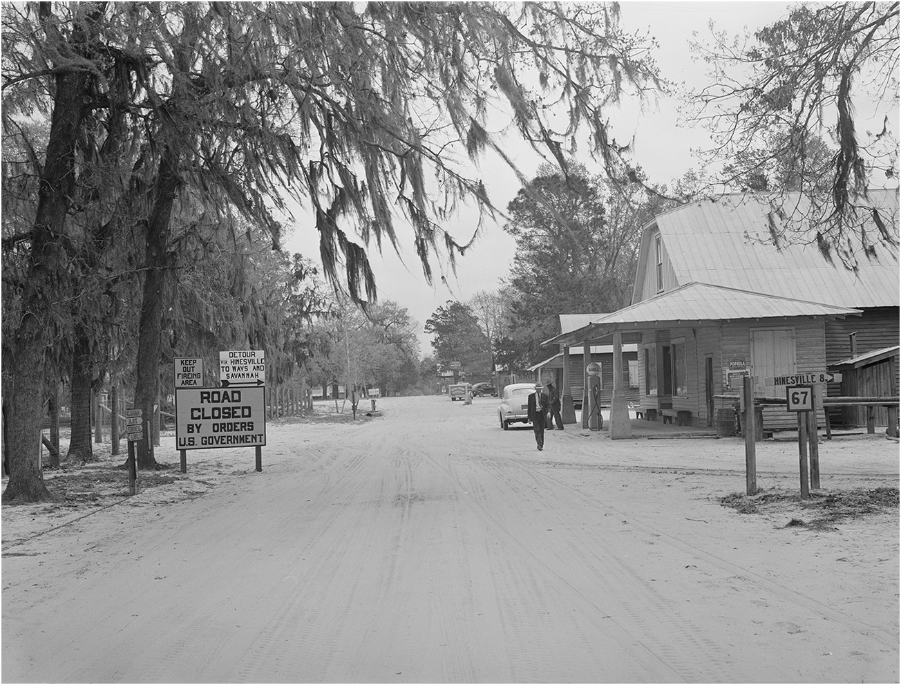
Figure 2.4 Main Street in Taylors Creek, a village that was evacuated to create Camp Stewart area, near Hinesville, Georgia, 1941.
The South Georgia land proved ideal for the army’s needs. The acreage could accommodate four regiments, 2,500 men at a time, and the terrain supported antiaircraft exercises. The climate permitted year-round training, three nearby Civilian Conservation Corps camps supplied ample construction workers, and existing defense installations, particularly Fort Screven and USAAF Hunter Field, were nearby. Further, the land was cheap, few people lived on it, and it had a first-class road and a railroad that provided links to Hinesville, the county seat of 500 people.Footnote 20
In the western United States during early 1942, the navy purchased 4,000 acres (roughly six square miles) of a 107,000-acre ranch located near present-day Irvine, California, to establish Marine Air Corps Station El Toro. Named for the nearby community of 130 inhabitants, the air station, which the Marines commissioned in 1943, provided facilities for two air groups to train combat pilots. A few miles from the Pacific Ocean, the location was without fog most of the year, the Santa Fe Railroad ran along the site’s western border, and the Marine Corps’ primary West Coast infantry training base, Camp Pendleton, was nearby. The El Toro land had belonged to James Irvine Jr., who cultivated black and lima beans on the property. In addition to fourteen 250-man wooden dormitories, the Marines built an airfield with three asphalt runways and underground gasoline storage tanks. El Toro remained active after the war and in 1950 became the permanent center of Marine Corps aviation on the West Coast.Footnote 21
Between the two coasts, the military acquired thousands of contiguous acres of land in isolated regions to permit high-speed fighter planes to perfect air-to-air gunnery tactics; heavy bombers to practice dropping live ammunition; and testing of nascent rocket and atomic weapons systems. The war and navy departments placed most bombing and artillery ranges on the poorest land available, primarily inferior public domain grazing acreage in western states and in limited areas of eastern woodlands, where costly land prices otherwise hindered development of large ranges.Footnote 22
For the highly secretive Manhattan Project, the war department purchased and leased approximately 550,000 acres (about 860 square miles) for the program’s main installations in Tennessee, New Mexico, and Washington. At Los Alamos, New Mexico, the US Forest Service provided 46,000 acres of the Santa Fe National Forest. The War Department bought another 8,900 acres of largely semiarid forest and grazing lands on the eastern slopes of the Jemez Mountains from a small number of private owners. In Tennessee, the Manhattan District acquired roughly 59,000 acres for the Clinton Engineer Works (later Oak Ridge National Laboratory), of which it purchased 56,000 acres for about $47 an acre from landowners of Roane and Anderson Counties on the western slope of the Cumberland Plateau. During the Great Depression, the region had been ravaged by floods, and a peach blight had further devastated the local economy. The Tennessee Valley Authority (TVA) had completed a dam nearby in 1942 that created navigable waterways and generated additional electricity – necessary infrastructure for the army’s nuclear research facility. However, the TVA’s use of eminent domain in the 1930s to acquire the land also uprooted hundreds of farmers from productive river-bottom farms. The Hanford Engineer Works site at Richland, Washington, included nearly 71,000 federally-held acres; 86,000 state- and county-controlled acres; 46,000 acres owned by railroad companies; and more than 225,000 acres belonging to private citizens and corporations. Private landowners had mostly planted fruits, asparagus, mint, and alfalfa. The flat, arid environment perfectly suited the plutonium production facility. Government officials considered it a remote, isolated wasteland, with abundant water from the Columbia River for electricity, and far enough inland to diminish concerns of an enemy attack. New Deal dams constructed nearby in the name of land reclamation, navigation improvement, and electricity production were the logical lure for the army’s plutonium producing nuclear reactors.Footnote 23
Geography also shaped ordnance plant site selection. Foremost, to thwart possible enemy attack, plants had to be placed inland from US borders and geographically dispersed. The War Department wanted plants manufacturing war chemicals and equipment located between the Appalachian and Rocky Mountains no closer than 200 miles from the nation’s borders and near to related factories positioned in five areas of the eastern half of this zone.Footnote 24 The army required high-quality agricultural land for the 29 completely new ordnance plants because engineers needed level land for excavating heavy building foundations and deep soil to diminish shocks in the event of an explosion. Production processes demanded sufficient local water supplies for sparkless steam power. Also, the land had to lie in open country, with 5,000- to 10,000-acre buffer zones to keep a single explosion from triggering a chain reaction, and for the general safety of residents. The plant location had to sit near enough to population centers for an adequate labor supply and close to rail and highway transportation to bring in raw materials and ship the finished armaments.Footnote 25
Badger Ordnance Works, 30 miles northwest of Madison, Wisconsin, was a typical ordnance facility. Built in 1942 on 10,565 acres (16.5 square miles) of fertile cultivated and pastured land, Badger produced smokeless gunpowder, solid rocket propellant fuel, and nitroglycerin for incorporation into small arms, cannons, grenades, and small rockets.Footnote 26 The War Department selected the Badger site largely because it consisted of gently rolling, less vulnerable interior lands with adequate drainage and excellent load-bearing capabilities far from large population centers. The facility was accessible by rail from significant shipping centers in Milwaukee, Chicago, St. Louis, St. Paul, and Kansas City, and the Wisconsin River flowed on the eastern boundary of the property.Footnote 27
Political factors also influenced the selection of one community over another for defense projects, and local interests frequently clashed. Businessmen campaigned to have war-related industries located in their towns to increase payrolls and trade. But local landowners typically protested site development, as it meant the loss of their farms and homes.Footnote 28 In the case of Badger Ordnance, many citizens questioned the sacrifice of rich farmland for the powder plant, as there was a sandy agricultural wasteland less than an hour north in Adams County. Almost 30 years after the war, Leo T. Crowley, a Wisconsin banker who was chairman of the Federal Deposit Insurance Corporation from 1934 to 1945, revealed that he had lobbied Gen. George C. Marshall to establish the plant near Baraboo. Crowley’s friend, Rowland L. “Bud” Williams, then president of the Chicago and Northwestern Railroad that ran through the area, wanted the additional business. Crowley’s relationship as an economic advisor to President Roosevelt likely influenced the army’s final site decision.Footnote 29
Presidential advisors also argued for placement of military installations and production plants in nonindustrial areas in the South and West to help boost those regions out of the Depression.Footnote 30 The defense economy that emerged during the war contributed directly to development of what an Army Air Corps official in 1944 termed the “sunshine belt.” This region south of the 37th parallel provided ideal training environs with little rainfall, mild winters, and friendly terrain from Georgia to California.Footnote 31
Between 1941 and 1945, wartime mobilization injected more than $4 billion of military investment into the South, transforming the region. In addition to training facilities and airfields, the war and navy departments brought new shipyards to the coasts of Virginia, Florida, Texas, North Carolina, and Mississippi; munitions and chemical warfare plants to Alabama; a bomber aircraft factory to Georgia; bauxite mining to Arkansas; and atomic weapons development to Tennessee. Scores of new military installations and supply depots stimulated new service industries from Virginia to Texas. The populations of 39 out of 48 southern urban areas grew dramatically: for example, Mobile, Alabama, grew by 61 percent and Norfolk, Virginia, by 57 percent.Footnote 32
In western states, war requirements also created new shipyards, aircraft plants, aluminum and steel factories, and weapons research facilities. Because the West served as the staging area for the war in the Pacific, the military established training camps, supply and munitions depots, and testing grounds throughout the region. Prior to the war, few large urban areas existed in the West, and mobilization hastened the growth of existing cities. San Diego doubled in size, and San Francisco and Los Angeles each grew by 30 percent in four years. Internal migration also increased racial and ethnic diversity in the West, particularly in the cities.Footnote 33
After the war, many military installations in this “sunshine belt” remained active and were enlarged, while others were placed on standby status and used by National Guard or Reserve units. Thus, World War II military expansion in the American South and West brought lasting change to the American landscape, such as infrastructure development, resource use, habitat destruction, and pollution, though it also prevented human development on some lands and preserved native habitat. Postwar, military service members and civilian employees permanently relocated to this region, laying the foundation for the Sunbelt’s massive urban and suburban development.Footnote 34
Methods of Military Land Acquisition and Alteration in Wartime
Military land procurement during wartime fundamentally differed from peacetime practices. During World War II, land acquisition happened hurriedly, with little time to consider alternatives. The armed forces secured acreage largely by leasing it from individuals and federal, state, and local agencies and by purchasing it from private citizens. Over the course of the war, the military leased approximately 43.3 million acres of primarily federal-, state-, and municipal-owned land, significantly more than the 6.7 million acres it purchased from private owners (see Table 2.2).Footnote 35 The US military preferred to lease federal land through executive orders, public land orders, and use permits instead of buying real estate because the process was fast, cost practically nothing, disrupted local populations only minimally, and reduced postwar property disposal problems. In general, defense agencies borrowed unimproved public land – raw acreage devoid of any development, construction, or site preparation – because laws required the government to restore property to its original condition or pay damages, which would often cost more than purchasing the property.Footnote 36
The land the military leased from state governments in the West for bombing ranges tended to be interspersed with federally owned land and Native American reservations. In some states, the armed services arranged exchanges of the intermingled land for acreage outside of military reservations because the states were reluctant to sell the property outright. Municipal entities often leased civil airfields and the adjacent lands to the military. Cites frequently offered leases for one dollar per year, extended water and power lines, and sponsored housing projects for officers and their families in an effort to woo investment to the area. The selection of municipal airports saved the army considerable time and effort because the infrastructure already existed for the facilities.Footnote 37
Land management bureaus and agencies of the US Departments of the Interior and Agriculture furnished the most federal land leased to the military, primarily in Oregon, Nevada, Arizona, California, New Mexico, and Utah. In the West, the federal government still owned large, contiguous swaths of public domain property in national forests, wildlife areas, Native American reservations, reclamation territories held for irrigation development, public water reserves, and otherwise vacant land. In the eastern and southeastern states, where less public domain land remained, the military leased forested tracts that were primarily cutover lands or privately owned, namely by paper and lumber companies and turpentine operators. The military converted many of these forest and grazing lands into bombing and artillery ranges.Footnote 38
Throughout the conflict, the war and navy departments collaborated with the Department of the Interior’s Fish and Wildlife Service (FWS) to repurpose more than 4.6 million acres of land on 33 national wildlife refuges in 18 states and the territory of Alaska as bombing and gunnery ranges, air bases, emergency landing fields, maneuver areas, docking facilities, and as recreational areas for men in training camps. Much of this acreage lay on property withdrawn during Depression-era submarginal land retirement programs in the South and Midwest. Several refuges acted as extensions of adjacent military artillery and gunnery ranges, including Patuxent National Wildlife Refuge (NWR) near Fort Meade, Maryland, and Wichita Mountains NWR, which adjoined Fort Sill, Oklahoma. The FWS also opened large sections of refuge lands to grazing, hay cutting, grain production, and nominal timber harvesting.Footnote 39
Because the armed forces did not use FWS refuge areas with high concentrations of wildlife, little harm came to the fauna from these activities. Generally, the army was sympathetic to wildlife concerns. For example, upon President Roosevelt’s request, the army spared nesting and resting grounds for the last remaining flock of Trumpeter Swans near Yellowstone National Park. It also withdrew plans to use moose-calving grounds on Kenai Peninsula in Alaska when wildlife managers raised objections. However, severe wartime damage did occur on the Aleutian Islands Refuge in Alaska, where 83,000 US troops established a presence on 18 islands to eradicate a 10,000-man Japanese force on two islands, Attu and Kiska, at the tip of the Aleutian Island chain.Footnote 40
During the war, the National Park Service (NPS) issued nearly 2,000 permits for use of its facilities for short-term maneuvers. The military operated in nearly all the national parks along the Pacific, Atlantic, and Gulf Coasts, such as Acadia, Olympic, and Glacier Bay National Parks and Fort Pulaski and Cabrillo Monuments, using those sites for defense installations and aircraft warning service posts. NPS specialists assisted with alpine warfare training at Mount Rainier and Mount McKinley (now Denali) National Parks and supported desert warfare training at parks in Arizona and southern California. The services also established recreation camps at the Grand Canyon, Sequoia, Mount McKinley, and Carlsbad Caverns parks and a rehabilitation facility for 7,000 patients in Yosemite’s Ahwahnee Hotel.Footnote 41
Secretary of the Interior Harold L. Ickes and NPS director Newton B. Drury were staunch conservationists who sought to protect national parks from unnecessary military use. Drury, with Ickes’s support, refused requests for the harvest of Sitka spruce trees in Olympic National Park for airplane construction, as had been done during World War I, and limited cattle and sheep grazing throughout the national parks. By 1946, the NPS terminated most of the military’s permits and returned the parks to their former condition as quickly as possible, but it also permanently transferred six land parcels totaling about 10,000 acres to the armed forces. The military left some parks in poor condition and changed the character of others. For example, at Cabrillo, the navy constructed batteries and observation posts near the Old Spanish Lighthouse, while the army’s use of Hawaii National Park for motorized maneuvers and firing practice caused extensive damage to the forests and other terrain and littered the area with unexploded ordnance.Footnote 42
The US Forest Service provided military use permits for 2.8 million acres of land under its stewardship, including the area ceded to the military for Eglin Airfield. By May 1946, the military had returned almost 1.4 million acres to the USFS. Overall, the greatest effect the war had on national forest land related to the use of its resources. The volume of timber harvested from those stands increased 89 percent between 1940 and 1944, although loggers kept mostly within the accepted standards of sustained-yield management on federal timber lands. These forests fed a wartime economy hungry for raw timber. According to historian Richard P. Tucker, “Construction lumber, which had consumed 27 billion board feet in 1941, rose sharply to 35 billion annually during the war, partly because of a huge program of military camp construction in the early months of the war.” Concurrently, tree plantings in national forests decreased 96 percent due to manpower and funding shortages. Grazing in the forests declined marginally, and the estimated population of big game increased 16 percent.Footnote 43
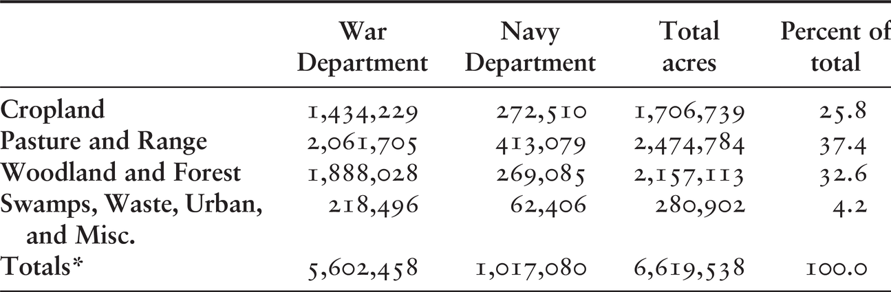
Laws that prohibited defense agencies from constructing permanent improvements on leased land led the military to purchase outright from private owners about 13 percent of the total land it acquired.Footnote 44 This type of acreage tended to have the highest use capabilities: of the total 6.7 million acres, about one-quarter had been cropland, one-third pasture and rangeland, and one-third woodland and forest, with the remainder in miscellaneous uses (see Table 2.3). In order of size, purchased parcels occurred primarily in California, Texas, Georgia, and Florida.Footnote 45
| War Department | Navy Department | Total acres | Percent of total | |
|---|---|---|---|---|
| Cropland | 1,434,229 | 272,510 | 1,706,739 | 25.8 |
| Pasture and Range | 2,061,705 | 413,079 | 2,474,784 | 37.4 |
| Woodland and Forest | 1,888,028 | 269,085 | 2,157,113 | 32.6 |
| Swamps, Waste, Urban, and Misc. | 218,496 | 62,406 | 280,902 | 4.2 |
| Totals* | 5,602,458 | 1,017,080 | 6,619,538 | 100.0 |
When voluntary sale of land could not be arranged, the federal government took possession primarily though the General Condemnation Statute (1888) and the Declaration of Taking Act (1931), with additional legislative authorities granted during the war. The military’s purchase of private property displaced an estimated 60,000 families from roughly 30,000 farms (see Map 2.3). The hurried acquisition of sizeable amounts of contiguous farmland during the war devastated the economic and social patterns of community life in certain areas. Lifelong residents scattered to new locales, school and road districts dissolved or combined with others, and tax bases withered.Footnote 46

Map 2.3 Major sites of land purchased from private owners by the war and navy departments during World War II.
Toward the war’s end, the Surplus Property Act of 1944 directed defense agencies to divest themselves of unneeded real estate. Almost all of the 10.3 million acres that the military leased from individuals and state and local governments reverted to the original proprietors after the conflict because most leases were stipulated to last only for the war’s duration. About one-third of the 33.1 million acres (9.3 million acres) of public domain and federal lands that other agencies had transferred to the military during the war reverted to their former tenants by June 1947. The military determined after the war that about a quarter of the land it had purchased or obtained through condemnation from private owners (1.6 million acres of the 6.7 million acres) was surplus, of which former owners reclaimed almost 1 million acres. However, federal officials declared that roughly one-third of this purchased land, about 2.5 million acres, was submarginal for agricultural use and as a result retained it in public ownership for forestry and grazing purposes.Footnote 47
While the government restored some wartime land to its original owners and managers, the military’s overall acreage increased from its prewar level largely because of evolving weapons systems such as tanks, bombers, amphibious vehicles, and long-range artillery, as well as nuclear testing, which required more space for safety and secrecy purposes. Overall, between June 1943 and June 1944, military-controlled landholdings of all types peaked at 52.7 million acres. By June 1945, after the Allies achieved victory in Europe, that amount fell to a roughly 25.1 million acres. As of October 1949, inventories showed the military retained a total of 23.1 million acres. However, Cold War exigencies led to a renewed defense buildup, and by June 1956, the military’s landholdings rose to 27.6 million acres, of which 16.9 million acres were lands removed from the public domain.Footnote 48
Environmental Legacies
The US military’s ready access to abundant, inexpensive land allowed its massive combined-arms forces to arrive on the World War II battlefields fully capable of unleashing faster, heavier, and more lethal weapons against its foes. During the war, military leaders – whose only substantive environmental concerns involved erosion, dust, and pest control – were largely ignorant of the long-term environmental effects of their activities. Their mission to fight and win wars did not account for the skills needed to properly manage the ballooning military land inventory. During the war, munitions production on formerly fertile farmlands, live-fire exercises on national forests turned into testing ranges, and improper disposal of munitions on newly restricted grazing lands contaminated millions of acres of land with hazardous and toxic compounds.
Throughout the early Cold War, military land managers focused on multiple-use hunting and fishing programs and sustained-yield timber production and did not prioritize other environmental concerns. During this time, DOD became the country’s biggest polluter, tainting soil and water with volatile organic chemicals, industrial solvents, and nuclear waste. In the 1970s and 1980s, the exponential increase of environmental legislation gradually shifted the Defense Department’s land management emphasis from consumptive uses of natural resources to strategies that complied with new environmental protection and remediation laws. In particular, through the National Environmental Protection Act (NEPA, 1969), Congress required DOD to conduct environmental remediation programs to address contamination from hazardous materials at active installations, formerly used defense sites, and other locations across the United States. By 1980, the Comprehensive Environmental Response, Compensation, and Liability Act (CERCLA, 1980) created the “Superfund” for remediation and established strict financial liability for the Defense Department to clean up environmental contamination on its installations. As of 1992, DOD possessed nearly 20,000 individual toxic waste sites and 81 percent of the properties on the federal facility National Priority List, commonly known as Superfund sites.Footnote 49
Cold War exigencies permitted the defense establishment to flout environmental regulations through to the end of the 1980s. Not until the first decade of the post‒Cold War era (1991–2001) did US politicians and policy makers compel the military to more effectively reconcile its defense mission with environmental laws. By the mid-to-late 1990s, the US military, reflecting the evolving national sentiment that favored increased environmental protection and the new sciences of restoration ecology and conservation biology, began implementing a more proactive, integrated ecosystem management approach. Certainly, the Pentagon has not always prioritized ecological stewardship, and the military’s motives for landscape conservation is focused on sustaining its mission, not altruism. But slowly, the Defense Department has recognized that proper natural resource management maintains the ecological integrity of its property and ultimately preserves and provides the realistic training conditions that are essential to military readiness.Footnote 50
As of 2018, most existing active military installations, and dozens that have closed over the last 30 years, trace their origins to the World War II era.Footnote 51 The following examples demonstrate how many of the land use and pollution patterns set during World War II continued and expanded during the Cold War decades and eventually became subject – often willingly, sometimes grudgingly – to evolving environmental remediation regulations.
Fort Stewart, Georgia
In 1940, the army removed a significant land area from active agricultural use and suppressed future human encroachment. Sustained military activity dating from World War II generated extensive environmental contamination, including unexploded ordnance on firing ranges and toxic chemicals from fuel operations and fire training facilities that leached into the soil and ground water. Since World War II, Fort Stewart has remained a principal army training complex, with only short idle periods between 1945 and 1950 and mid-1972 to 1974. As required by 1970s environmental laws, the army initiated contaminant prevention, remediation, and mitigation efforts that have helped the land recover from extreme use.Footnote 52
Since 2005, army personnel at Fort Stewart have reduced by 75 percent the use of toxic and hazardous chemicals through Resource Conservation and Recovery Act (1976) training and proactive measures by the garrison’s Environmental Division; however, the effects of the remaining hazardous material on fauna are not known. According to a 1993 statement from the US Army Environmental Center, the military rarely conducts field studies about the effects of toxic contaminants on wildlife unless there has been “noticeable and unusual wildlife mortality, failed breeding, or physical disfigurement.” Where contamination risks to wildlife are extreme, the military constructs fences and emits simulated distress calls to warn wildlife away from the poisonous areas while it attempts to remove toxic materials and filter ground water to diminish the hazards. What is known is that implementation of a prescribed controlled burning program on Fort Stewart has created the largest remaining acreage of a longleaf pine-wiregrass ecosystem, which in turn sustains several threatened and endangered animal species.Footnote 53
Marine Corps Air Station, El Toro, California
Aviation activities at the base for more than 50 years starting in World War II, combined with nonexistent or lax fledgling environmental laws and inadequate disposal methods, contaminated the soil and groundwater at El Toro with volatile and semivolatile organic compounds, petroleum hydrocarbons, arsenic, and metals. In the mid-1980s, the Department of the Navy identified the sources of contamination and began environmental remediation (see Figure 2.5). In 1990, while the base was still active, the Environmental Protection Agency assigned it to its Superfund list.Footnote 54 In 1999, the navy decommissioned El Toro but continued its restoration program. By 2014, through soil sampling, excavation activities, and groundwater treatment, the navy and local agencies had cleaned up the contamination to the point that it no longer posed a risk to human health or the environment. In 2015 private builders began developing 9,500 homes and parkland in the middle of the former air station, with some of the other restored property used for agriculture.Footnote 55
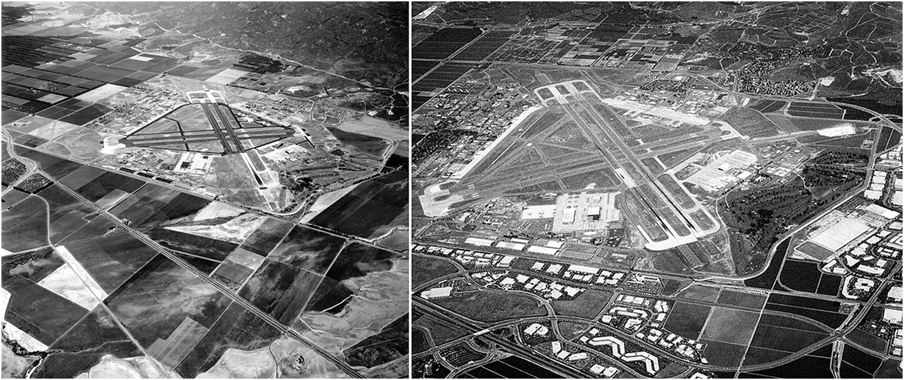
Figure 2.5 Aerial view of Marine Corps Air Station, El Toro, California, 1962 (left) and 1993 (right).
Badger Ordnance Works, Baraboo, Wisconsin
After World War II, the army maintained Badger on standby status, reactivating it for the Korean and Vietnam wars. In 1975, the plant ceased production of explosives, and in 1997, the Defense Department decommissioned the facility (see Figure 2.6). In its final closing, Badger left behind an environmental legacy of toxic solvents, metals, and explosive waste onsite that had contaminated the nearby air, water, and soil. For the past three decades, the army has been conducting cleanup efforts: soil and water have been remediated, nearly 1,400 buildings demolished, and utility lines and railroad tracks removed.Footnote 56 Badger’s final closing in 1997 initiated another shift in land use, with an inadvertent positive outcome: it has become a refuge for numerous rare bird and plant species. In 2016, the army transferred portions of the property to public and private conservation groups, creating the Sauk Prairie Recreation Area.Footnote 57
Eglin Air Force Base, Florida
Eglin of the late 2010s exhibits an enigmatic environmental paradox: although military lands are often highly contaminated with unexploded ordnance and other hazardous materials, because of their remoteness and lack of human development, they are highly biologically diverse. While this base has experienced the same contamination problems as the installations mentioned in the preceding text, it employs a robust environmental quality team to reduce risks and maintain compliance with environmental regulations. As of 2018, Eglin is the largest forested military reservation in the United States, providing 227,000 acres open for public recreational use, with only 60,000 acres permanently closed to the public. Roughly 400,000 acres are unimproved forests and beaches with diverse habitats that sustain eleven federally listed threatened and endangered species, including loggerhead sea turtles, red-cockaded woodpeckers, and Okaloosa darters. Eglin’s military mission is relatively compatible with biodiversity goals: because it is an air force base, damage from tanks and tracked vehicles is minimal, and wildfires caused by training exercises have unintentionally improved the longleaf pine habitat nearby.Footnote 58 These conservation activities are not limited to Eglin but have become the new norm at installations across the United States, where fostering environmental sustainability has become conscious decision rather than a happenstance.
Conclusions
Innovations in military technology revolutionized the strategy and tactics unleashed to wage World War II. These new ways of war, and the mammoth US fighting force that executed them, required large expanses of land to train and perfect military maneuvers. During the conflict, the military’s ready access to the quantity and quality of land it needed for defense plants, weapons testing, and troop training proved a substantial, and often forgotten, asset to the American war effort.Footnote 59 Immediately after the war, the armed forces returned some of the surplus leased property to its former owners or tenants. However, defense agencies retained most of the permanent installations they had established on purchased properties and on large expanses of land transferred or leased from the federal public domain. The majority of land the military kept, both leased and purchased, was located in southern and western Sunbelt states where weather, topography, and isolation offered favorable conditions for military activities. While mobilization for World War II rejuvenated the entire US economy, it also radically transformed the South and West and facilitated the creation of today’s Sunbelt.
The environmental vestiges of World War II defense land acquisition manifested immediately and persisted over decades. When the military first procured new land, it altered the prevailing land uses and as a result, changed landscapes. Intense military use during World War II and the Cold War, coupled with limited environmental and waste disposal knowledge and laws, created significant soil, air, and water contamination. The development of environmental science and the statutes that followed, and later waves of base closures, revealed a toxic legacy of poor ecological practices on military installations. Numerous congressional investigations, news media exposés, and scholarly works have detailed the enduring impact of the military’s improper waste disposal methods, use of uncontrolled toxic materials, inadequate fuel storage facilities, and unexploded ordnance hazards.Footnote 60
Beginning in the early 1970s, Congress has required that all the military services comply with modern environmental regulations on currently active military installations. Although much work remains, decommissioned installations have undergone extensive remediation efforts and are being repurposed as economic development districts, wildlife refuges, and recreational areas. A lesser-known sequel to the military’s procurement of vast amounts of land for World War II is the current-day, vigorous maintenance of ecologically diverse habitats for more than 550 threatened and endangered plants and animals on more than 25 million acres of active military land in the United States. After decades of adversely impacting the land, the Department of Defense is slowly and unevenly emerging as an unexpected agent of environmental restoration and conservation while still sustaining its training areas and ranges for military use.Footnote 61