


Introduction
The more accurate the equipment used in topographical surveys, the better the representation of space will be. In recent years the need for geolocation data has increased considerably, so that this information has been improved and arranged in various electronics that are of daily use to people, such as smartphones that, due to constant evolutions, development and improvement of applications, have demonstrated unlimited options for work in the area of topography (Gonçalves & Borges, Reference Gonçalves and Borges2016). The use of GPSs and smartphones for topographic surveys is mostly facilitated by their operational systems, but this use should be tested to ensure the accuracy of the data obtained (Yoon et al., Reference Yoon, Kee, Seo and Park2016), since the use of equipment with these technologies without observing the technical characteristics as to the accuracy limit of each device can generate numerous errors and may even compromise the entire result of the work performed (Moreira et al., Reference Moreira, Lemos, Rocha and Santos2014).
Objective
The aim of this study was to verify the accuracy of topographic surveys performed with navigation receivers and Smartphone (planimetric and altitude survey).
Methods
The GPS RTK GNSS Receiver (X900) was used as a reference for comparative analysis of topographical survey performance, and the GPSmap 76CSx (RNC) receivers and a popular branded with Android 7.0 operating system and the C7 GPS Data and GPS Essentials mobile applications. To delimit the area, wooden pickets were allocated at 17 previously identified points, forming a closed polygonal in the study area. The coordinates obtained from the GPS RTK receiver were considered as reference positioning coordinates. The data were then collected with the GPS RNC, and with the smartphone with the applications. All receivers were configured to obtain UTM plane coordinates and SIRGAS2000 Horizontal Datum. With the data, the discrepancies between coordinates and the resulting discrepancy were determined, being: ∆E = ET-ER; ∆N=NT-NR; ∆H=HT-HR and ∆d = √∆E2 + ∆N2, where ∆E are coordinate discrepancies East, ∆N discrepancies of coordinates North, ∆d resulting discrepancy, T are the coordinates to be tested and R are the reference coordinates.
Results
The results obtained indicate that the RNC presented results of Δd lower than those found by the other receivers, with about 1.73 m. The Smartphone with C7 GPS Data showed similar results, with a Δd of 2.1 m (Table 1). When comparing the ΔH, the lowest error values were recorded at the points marked with the Smartphone with C7 GPS Data, with an average of 2.79 m (Table 2). A considerable difference between the coordinates recorded with the applications on the same smartphone can be observed. For the total area the biggest error was observed by the Smartphone with Essential GPS, with an underestimate of approximately 4% in the total area and 0.39% in the perimeter. The altimetric profiles made showed that there is a discrepancy between the profiles drawn by the RTK GPS and the other receivers (Fig. 1). However, the receivers evaluated showed a trend very close to the RTK GPS profile.
Table 1. Positioning discrepancies, in meters, of North UTM coordinates (ΔN), East (ΔE), geometric altitude (ΔH) and horizontal distance error (Δd) of topographic surveys performed with GPS navigation.
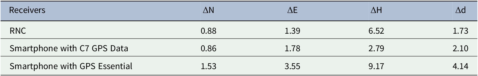
Table 2. Total area, perimeter and their respective errors (ΔA and ΔP) of the surveys conducted with different receivers.
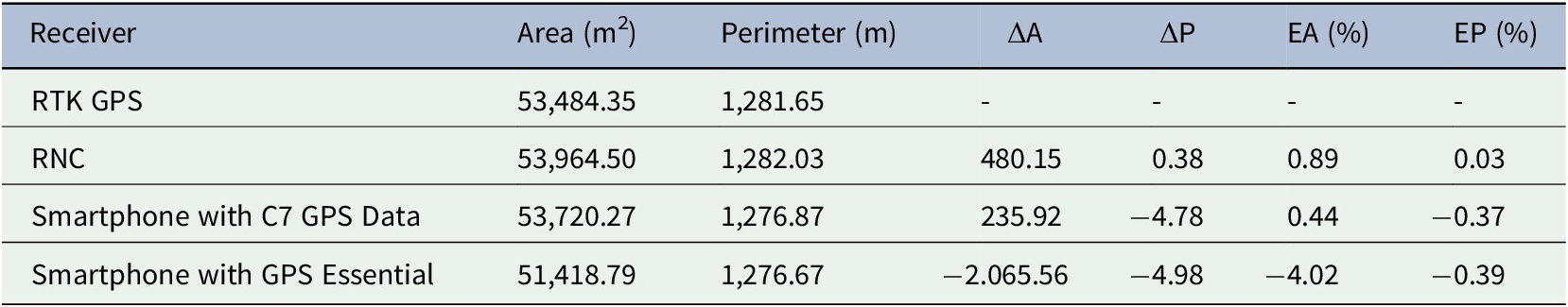
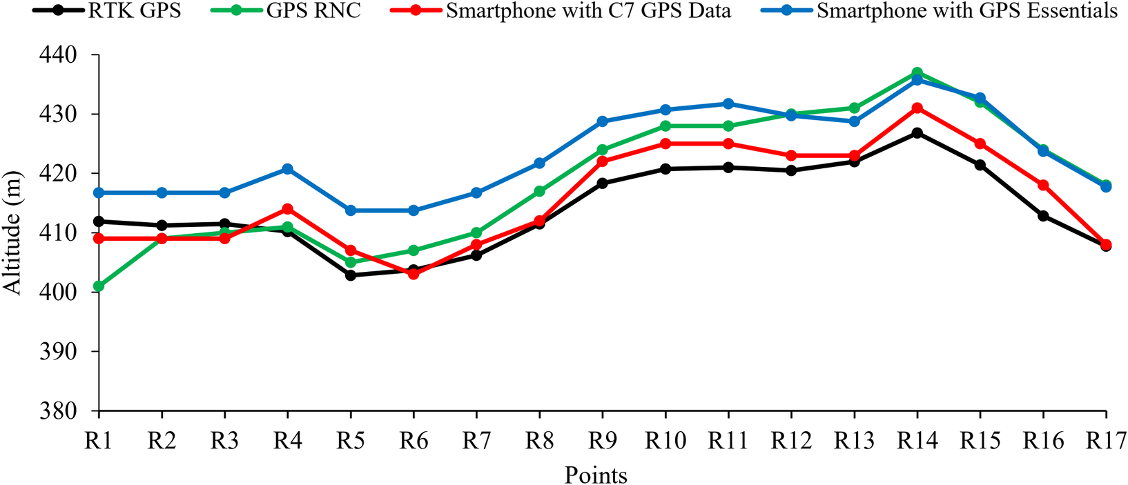
Figure 1. Altimetric profile performed with different receivers. RNC - Commercial Navigation Receiver.
Discussions
The significant differences between the coordinates recorded with the applications in the same Smartphone indicate that their programming may have interfered in the collection of this data, since the surveys were conducted on the same day, time and place. The use of GPS navigation, including mobile applications, in small topographic surveys is feasible, since the errors (EA and EP) found, although considerable, did not exceed the margin of 5% considering the variation for more or less. The data obtained corroborates with Machado and Molin (Reference Machado and Molin2011) that registered EA under 3 m when evaluating various navigation GPSs, and Moreira et al. (Reference Moreira, Lemos, Rocha and Santos2014) that recorded errors of less than 4 m. Hwang et al. (Reference Hwang, Yun, Suh, Cho and Lee2012) and Dabove and Pietra (Reference Dabove and Pietra2019) state that a viable alternative to reduce errors in topographic surveys conducted by navigation GPSs would be the development of applications capable of using Network Real-Time Kinematic (NRTK) GPS data technology in their surveys.
Conclusions
The GPS RNC showed the best planimetric results and the Smartphone with GPS Essential the worst result. For altimetry, the Smartphone with C7 GPS Data obtained the best result, and the worst being again the Smartphone with GPS Essential. None of the receivers analyzed showed satisfactory results for jobs requiring high accuracy. However, they can be used for tasks where high precision is not required.
Author Contributions
MJMG and CAM conceived the study. MJMG, LRSA and FAR conducted data collection. IEAS performed statistical analyses. MJMG wrote the article.
Funding Information
This research received no specific grant from any funding agency, commercial or not-for-profit sectors.
Conflicts of Interest
All authors declare no conflicts of interest.
Data availability
The authors confirm that the data supporting the findings of this study are available within the article and/or its supplementary materials. If additional data is required, is available from the corresponding author, [MJMG], upon reasonable request.
Supplementary Materials
To view supplementary material for this article, please visit http://dx.doi.org/10.1017/exp.2020.27.
Acknowledgements.
The authors would like to thank Instituto Federal de Educação, Ciência e Tecnologia do Sertão Pernambucano for their technical assistance.


 Open access
Comments
Comments to the Author: The evaluated work is well written, detailed and succinct in what was proposed in the general objective, directly corroborating the results presented and discussed later with relevant references from the literature.