


One of the primary regions for understanding the process of Anatomically Modern Human dispersal and migration is the Nile Valley and the coast of the Red Sea, including Sudan, Egypt and Ethiopia (Rose et al. Reference Rose2011; Goder-Goldberger Reference Goder-Goldberger2014). Nubian technology has been used to trace the migration from Africa to the Arabian Peninsula (van Peer 1998), sometime between 150 000 and 60 000 years ago. Middle Stone Age sites are relatively rare in Sudan, known only from work carried out on the Sudanese-Egyptian border by Marks in the 1960s (e.g. Marks Reference Marks1968) and later by van Peer (van Peer 1998; van Peer et al. 2003). The coast of Sudan has recently been the focus of research by Beyin's team (Beyin et al. Reference Beyin, Chauhan and Nassr2019a & b), while the Nile Valley near the Fourth Cataract has been investigated by Olszewski and the University of Pennsylvania Team (Olszewski pers. comm.).
Our work focused on Kerma, in the Nile Valley region, northern Sudan, just south of the Third Cataract (Figure 1). Here, we present the preliminary results from a survey in January 2019. This builds on investigations by Matthieu Honegger in 2007–2008, which surveyed the region for Holocene human occupation (Honegger & Williams Reference Honegger and Williams2015).

Figure 1. Map of the research area showing the locations of the new sites (drawing by N. Bicho).
The recent investigations located 16 new Middle Stone Age sites during a 60km walking survey and 100km drive, in two north–south transects that lay 15km and 25km east of the Nile respectively. Four types of sites are evident in the region. The most common is the surface site, located on flat stone pavement desert areas and directly associated with hilly basalt outcrops, no more than 15–20m high. These outcrops are visible in the landscape from a distance (Figure 2). The second site type occurs in small quarry locations atop large basalt volcanic plugs. An example is Jebel-el-Azrak, a 150m-high hill visible from at least 15km away (Figure 3). These sites comprise circular flat areas with thousands of artefacts made from the local basalt. The circular features appear to be a result of the exploitation of large surface basalt blocks that were used to manufacture the artefacts.
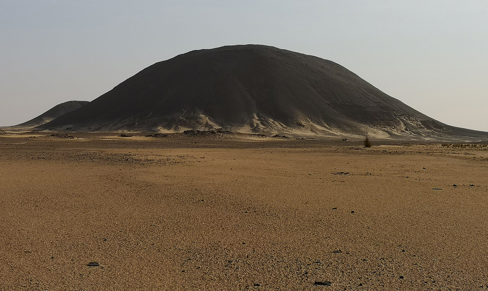
Figure 2. The Jebel-el-Azrak basalt plug (photograph by N. Bicho).

Figure 3. Two lithic workshop areas on top of Jebel-el-Azrak (photograph by N. Bicho).
Several sites are located on the dunes resting against the base of the basalt plug. Some have evidence for using the local basalt for producing the artefacts, and others for the exploitation of quartzite coming from the local bedrock, exposed at the time of the basalt extrusion. Some of these may be in situ, below or inside the dunes. The final site-type is the rockshelter; these are natural shelters formed by the local Nubian Sandstone (Figure 4). At least one such location has evidence of Middle Stone Age lithic artefacts on the surface, mixed with more recent material, suggesting that the site has a long sequence.

Figure 4. The SK7 rockshelter (photograph by N. Bicho).
All sites seem to be related to the exploitation of local raw materials, usually the primary sources of basalt or quartzite still visible today in the arid landscape. In the south of the study area, the quality of the basalt, as a raw material, diminishes, and with it the frequency of sites and the number of artefacts on each site. The largest basalt outcrop is the volcanic plug Jebel-el-Azrak. On top of this, there are at least five circular loci that were used to exploit the basalt. Around those loci we found various large-scale pieces of basalt, each weighing over 1kg and measuring at least 0.2m in length. As these objects seem to be associated with the removal of large flakes from the local bedrock, they are interpreted as wedges to crack and remove large basalt blanks that were then used to manufacture Levallois technology. This technique is also apparent at other sites, where the basalt outcrops show evidence for the removal of large flakes, likely to have been used as cores (Figure 5). Significant amounts of small debris from shaping and core preparation are found in association with these locations.

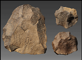
Figure 5. Centripetal cores: 1–3 from Jebel-el-Azrak; 4 from SK6; 5–6 from SK11; 7–9 from SK141 (photograph by N. Bicho).
The technology at the sites is marked by the presence of Levallois centripetal preferential cores, rare Nubian type 2 cores, and traditional discoidal cores. These are mostly made from basalt, but there are also some in quartzite and more rarely in quartz. The cores were used to produce Levallois flakes, blades and points (Figure 6). There are very few retouched tools. There is no evidence for the presence of either Nubian type 1 cores or of Khormusan technology (Marks Reference Marks1968; Goder-Goldberger Reference Goder-Goldberger2013).

Figure 6. Scale piece (the left two faces) and Levallois points (the right three images) from Jebel-el-Azrak (photograph by N. Bicho).
Our short fieldwork survey demonstrates that the Kerma region is characterised by a high potential for Stone Age preservation. One reason for this is the presence of important alluvial sedimentary deposits dating between c. 150 000 and 20 000 years ago, indicating that there were several geological events in which the Nile shifted laterally and deposited sediments (Williams Reference Williams2019). This area is called the Kerma alluvial plain, reaching our survey area, some 15–20km east of the present course of the Nile. This region is crossed by three older Nile channels. The plain is bounded to the east by the Mesozoic Nubian Sandstone plateau, some 150m higher; the plateau is cut in places by Cenozoic basalt plugs that form individual hills of varying heights. There is evidence for channels radiating from the plateau and running to the Nile through the alluvial plain. In places, there are fluvial gravels above the Nubian sandstone forming alluvial deposits within the aeolian desert sands. These were likely deposited during periods of high-energy Nile channel flow; for example, when the river was in flood and as a result of seasonal discharge. In addition, fluvial sands as well as clay deposits indicate periods of wetter conditions and greater vegetation cover, at least seasonally. This ecology, even if only momentary and seasonal, was adequate to sustain the local and regional human occupation as well as creating favourable conditions for migration and dispersal in the Nile Valley.
Based on the lithic technology and recent dating of the sand dunes in the region (Williams Reference Williams2019), the likely date for these assemblages is between 120 000 and 60 000 years ago. The ecology of the landscape during wetter phases suggests that the Kerma region may be a key location for understanding viable routes from Africa to Arabia (Rose & Marks Reference Rose and Marks2014; Groucutt et al. 2015) for the Anatomically Modern Human diaspora during the Middle Stone Age.
Acknowledgements
We wish to thank Foundation Kerma, the Swiss National Fund for Scientific Research and the Portuguese Fundação para a Ciência e a Tecnologia (grant UID/ARQ/04211/2019-ICAr EHB) for funding the first season of the ‘Kerma Middle Stone Age’ project.


