


Introduction
Architecture has been a central thread in how the history of the Balearic Islands has been told and studied. The scale of the constructions made with cyclopean stones and their visibility across the landscape have made them a key feature in our approach and understanding of the first millennium bc in the Balearic Islands. The primary goal of this research is to analyse how monumental communal architecture enabled the construction of enduring social spaces, and how the role of these spaces within the community can be understood through the relations that conform across the landscape. We will focus on the Late Bronze Age (1100–850 bc) and the Talayotic period (c. 850–650 bc), the first moment when cyclopean dry-stone architecture is used in communal spaces, making them stand out across the landscape. However, the diversity of buildings and of the archaeological contexts documented in them makes it difficult to assign a single function to each architectural type. For that, we turn to the concept of assemblages (Bennett Reference Bennett2010; DeLanda Reference DeLanda2006; Reference DeLanda2016; Deleuze & Guattari Reference Deleuze and Guattari1988), which allows us to focus not on the buildings alone, but rather on the relationships that they fostered and enabled. In so doing, we will explore these relationships through a range of GIS analysis to show how architecture created a network across the entire landscape, and that the characteristics and properties of this network are key in understanding the relationship between Talayotic communities and their landscape.
Talayotic architecture in Mallorca
The Talayotic culture has been the main focus for the prehistoric history of the islands, maybe because many constructions still stand in today's Mallorcan and Minorcan landscape. The name Talayotic comes from the Catalan word talaia [watch tower], which is the name given to its most iconic architecture, the talayots, turriform constructions made of large stone blocks with a dry-stone construction technique. However, they are not the only communal cyclopean dry-stone architecture that still stands across the island's landscape.
Around 1000 bc a trend can be traced across the islands, as Bronze Age sites, characterized by naviform habitats, were progressively abandoned in favour of new habitat spaces that tend to show a grouping of structures around a central building (Guerrero et al. Reference Guerrero Ayuso, Calvo Trias, García Rosselló and Gornés Hachero2007; Lull et al. Reference Lull, Micó, Rihuete Herrada and Risch1999). These new sites, built c. 900/800 bc, show a formal separation between domestic and communal structure. In them, the domestic structures are built attached one to another, with variable plant forms (trapezoidal, kidney-shaped, rectangular) and dimensions, although all use a building technique with small stonework, which differentiates them from the cyclopean building technique that was previously used in habitat spaces, the naviforms (Salvà Simonet & Hernández-Gasch Reference Salvà Simonet, Hernández-Gasch and Belarte2009). In contrast, a new range of communal structures take over the building technique tradition of cyclopean stonework, which was previously a marker of the naviform habitats.
The slow change from an architectural monumentality centred in domestic spaces to one that focused on community spaces starts with the construction of the first turriforms. Turriforms are tower-like constructions, with an irregular floorplan, and present some diversity in their architectural features. They have been considered the precursors to talayots (Gelabert Oliver Reference Gelabert Oliver2018, 159). However, the first constructions that are generalized across the island of Mallorca are the tumulus or stepped turriforms. These are solid structures composed of steps or horizontal walls with a three-part structure. Aramburu-Zabala Higuera (Reference Aramburu-Zabala Higuera1998) has documented 117 of these buildings in the island of Mallorca, the large numbers demonstrating their importance in the island's talayotic landscape. Data from excavated tumuli show that they are spaces not used for domestic activities, but for community ones, although these were very varied. There is not much information about the use of these structures during the Talayotic period, as they were constantly reinterpreted as places of social significance during the subsequent centuries. Excavations show how some of them were built on top of Bronze Age structures, such as Son Oms (Rosselló Bordoy Reference Rosselló Bordoy1963; Reference Rosselló Bordoy1965; Rosselló Bordoy & Camps Reference Rosselló Bordoy and Camps1973) and Son Ferrer (Calvo Trias et al. Reference Anglada, Ferrer, Plantalamor, Ramis, van Strydonck and De Mulder2014), the latter being also reused as a necropolis during the Postalayotic period (c. 650–123 bc). However, the lack of domestic elements in the Talayotic contexts, their location and architecture has let to their interpretation as community gathering places. Radiocarbon dating suggests that they were built c. 1100/1000 bc (Calvo Trias et al. Reference Anglada, Ferrer, Plantalamor, Ramis, van Strydonck and De Mulder2014; Gelabert Oliver et al. Reference Gelabert Oliver, Hernández-Gasch and Puig Palerm2018; Micó Reference Micó2005).
Talayots are the most significant architecture of the Talayotic period. Talayots are tower structures built with a three-part cyclopean technique. In Mallorca they have an internal chamber, which can have a polylithic central column and an entry with a corridor. They would have been covered by a platform built with wooden beams or large stone slabs disposed around the central column, and a roof made of clay and wood. Although this is a general description, each Talayot is different and might present additional elements such as zigzag entry passages (Aramburu-Zabala Higuera Reference Aramburu-Zabala Higuera1998; Gelabert Oliver Reference Gelabert Oliver2018). Nowadays in the island there are approximately 237 circular talayots and 104 square ones, which can be found in settlements alongside habitat structures, as well as scattered throughout the landscape (Aramburu-Zabala Higuera Reference Aramburu-Zabala Higuera1998). The archaeological data show how the materials and activities in talayots are significantly different from the ones documented in domestic spaces. And they can differ between talayots, even between ones in the same site. For that, they are understood as places for supra-domestic or communal activities. For example, at Son Fornés (Montuïri), Talayot 1 was a meat-processing space, where the butchering of goat and sheep occurred. This has been interpreted as communal management of the flock, which was afterwards distributed among the different domestic units. Also, in the talayot there was evidence of meat consumption, indicating the possibility of communal feasts. In contrast, Talayot 2 seems to have been a meeting place, as in it small ceramic pots for liquid consumption, as well as evidence of meat consumption, have been documented (Gasull et al. Reference Gasull, Lull and Sanahuja1984; Lull et al. Reference Lull, Micó, Rihuete Herrada and Risch2001). Other examples are the talayot of Son Fred (Sencelles) where a large concentration of cereals was found (Aramburu-Zabala Higuera Reference Aramburu-Zabala Higuera2009), while in the square talayot of Cascanar there were large pottery containers as well as small vases, hammerstones and copper mineral (Aramburu-Zabala Higuera Reference Aramburu-Zabala Higuera2011).
The idea of talayots as gathering spaces for the community is reinforced by the calculations of work investment in the buildings, which have led us to interpret that their construction was an event where all the community participated, and was a group cohesion strategy (Gasull et al. Reference Gasull, Lull and Sanahuja1984; Gelabert Oliver Reference Gelabert Oliver2018; Lull et al. Reference Lull, Micó, Rihuete Herrada and Risch2001). This is also connected to the size and building technique of this architecture, which indicates a desire for visibility and permanence across time (Criado Boado Reference Criado Boado2012), that is, a will to see and to be seen (Calvo Trias Reference Calvo Trias2009; Galmés Alba Reference Galmés Alba2015).
Talayotic architecture as an assemblage
Although these buildings share many similarities, each has their own unique characteristics. This makes establishing an architectural typology difficult. Typologies are often a synonym for function or social arenas, which are extrapolated to different identities or social institutions (Bille & Sørensen Reference Bille, Sørensen, Bille and Sørensen2016). However, a building rarely presents only one function. In this sense, the shape of architecture is not a result solely dependent on physical elements or a specific design, but is a consequence of a series of affects, assemblages and social, cultural, or economical meanings, among others. To understand the complexity of these buildings, we propose to conceptualize them as an assemblage. This term comes from the works of Deleuze and Guattari (Reference Deleuze and Guattari1988) and has been elaborated by authors such as DeLanda (Reference DeLanda2006; Reference DeLanda2016) or Bennett (Reference Bennett2010). Assemblages result from the temporal gatherings of different types of relations, materials, meanings and ideas. They are the fluxes of matter, energy, ideas, people, objects, materials, places and technologies that are tangled and organized in limitless combinations and are always in the process of change (Crellin Reference Crellin2020; Fowler Reference Fowler, Alberti, Jones and Pollard2013a; Fowler & Harris Reference Fowler and Harris2015; Hamilakis & Jones Reference Hamilakis and Jones2017; Jervis Reference Jervis2019). A key aspect in trying to understand the world as assemblages is to focus on relations. The assemblage is understood as relational, but exceeds the terms of its relations; it is more than the sum of its parts (DeLanda Reference DeLanda2006; Reference DeLanda2016). This relational approach permits focus on how relations shape things, more than on the materiality itself (Crellin Reference Crellin2017; Fowler Reference Fowler, Alberti, Jones and Pollard2013a, Reference Fowlerb; Fowler & Harris Reference Fowler and Harris2015; Harris Reference Harris2014; Lucas Reference Lucas2012).
In this sense, the assemblage can be understood as a concurrent process, in which diverse components come together to constitute an entity, a set of relations. This coming together process is the so-called territorialization and deterritoralization and must be understood as constant. The relation between elements, however, is not random but rather historically contingent and emerges through past processes that continue to develop in the present (Crellin Reference Crellin2020; Fowler & Harris Reference Fowler and Harris2015). A key aspect of the territorialization of the architecture in this case study is the cyclopean dry-stone construction technique, which has enabled the survival of these constructions. It is important to remember that architecture's materials condition the sensorial experience of it (Love Reference Love, Bille and Sørensen2016). These buildings highlight the importance of materiality, as its stability has allowed the territorialization of these places (Cipolla Reference Cipolla2018; Criado Boado Reference Criado Boado2012; Ingold Reference Ingold2007). In this sense, understanding architecture as an assemblage, as a myriad of components, allows us to conceptualize it as a constant process instead of a static element (Beck Reference Beck2018; Crellin Reference Crellin2020; McFadyen Reference McFadyen, Bruno and Thomas2008).
Thinking through assemblages permits understanding architecture as more than the physical construction of the building, and includes the processes of building and restoration, of people, tools, practices, norms, etc., which have influenced the building tradition as well as the ways in which people lived in, with and around these buildings (Beck Reference Beck2018; Bille & Sørensen Reference Bille, Sørensen, Bille and Sørensen2016; Lucas Reference Lucas2012; Normark Reference Normark2009). In this sense, the idea of architecture as an assemblage allows us to see the variations within the type, as well as the processes of development of the architectural tradition; while typology is still interesting to map the general development of it (Beck Reference Beck2018, 155). Thus it permits mapping the historical processes that generate the assemblage, and establishes connections that help to understand how architectural traditions emerge, are maintained and dismantled, in a process of constant change (Beck Reference Beck2018; Bille & Sørensen Reference Bille, Sørensen, Bille and Sørensen2016; Normark Reference Normark2009; Van Oyen Reference Van Oyen2015). Instead of understanding the different buildings as versions of an ideal archetype, we understand them as structures in a constant dialogue and part of the same architectural tradition, but each of them representing a different historical situation, which adds variation to the tradition (Beck Reference Beck2018, 155).
To analyse this difference in repetition three areas of the island have been analysed, to understand how talayotic communities emerged and made themselves visible in the landscape through architecture. Talayotic architecture occupied a prominent place in the landscape, as a place where practices, memories and materials were territorialized. This architecture is not a reflection of the community, but part of it, and opens a range of possibilities of action.
Methodology
This study seeks to understand how talayotic architecture showcases a will to be seen (Calvo Trias Reference Calvo Trias2009; Galmés Alba Reference Galmés Alba2015) by analysing the occupation of the insular landscape and the role of architecture in marking a place as well as the relations that these places enabled. Three areas across the island of Mallorca were selected (Fig. 1) based on the number of sites preserved, that they had at least one site totally or partially excavated, and their location on the coastline. The coastal location of these areas allows us to evaluate the impact of the integration of the island in the Mediterranean connectivity networks, a component of the study that will be more thoroughly explored in forthcoming papers. A total of 59 sites ascribed to the Talayotic period have been studied across the three areas. Each site was surveyed to estimate its last occupation through surface pottery (Galmés Alba Reference Galmés Alba2021). However, radiocarbon data from excavated sites show how Talayotic communal structures were built over a relatively short period of time, and were in use between c. 850 and 650 bc, although their abandonment and reuse processes differ from site to site (Anglada et al. Reference Anglada, Ferrer, Plantalamor, Ramis, van Strydonck and De Mulder2014; Calvo Trias et al. Reference Anglada, Ferrer, Plantalamor, Ramis, van Strydonck and De Mulder2014; De Mulder & van Strydonck Reference De Mulder, van Strydonck, Albertazzi, Muti and Saggio2021; Gelabert Oliver et al. Reference Gelabert Oliver, Hernández-Gasch and Puig Palerm2018; Lull et al. Reference Lull, Micó, Palomar, Rihuete Herrada and Risch2008; Micó Reference Micó2005).
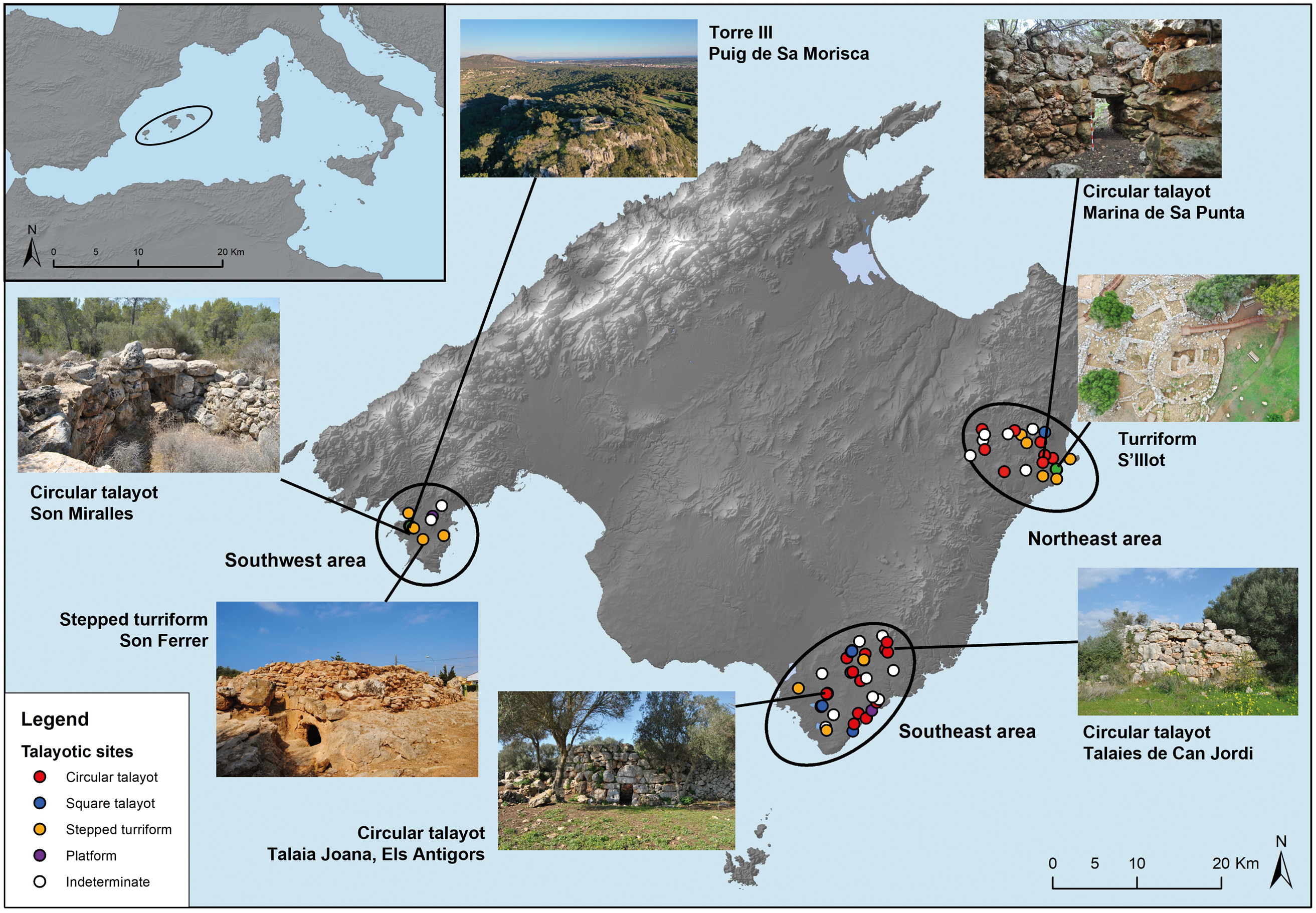
Figure 1. Location of the island of Mallorca, areas of study, and illustrations of some sites and architectures.
Through a range of GIS-analysis, we demonstrate how together the architecture and its location created a network across the landscape, and how this is a key aspect in understanding the relations between the communities and their landscape. Through the combination of several approaches that have previously been presented as case-studies, we tested the applicability of these methodologies and showed how their combination in a problem-driven way allows us to go much further in our understanding of our case study.Footnote 1 We have focused on the exploration of visibility as the magnitude of the architecture, and its construction techniques, showcased an active will to be visible places (Criado Boado Reference Criado Boado2012).
However, GIS methodologies require a simplification of visibility. Perception is embedded in memories, affects, experiences and temporality (Gillings Reference Gillings2015; Hamilakis Reference Hamilakis2013). Architecture has an active role in the landscape, with the capacity of territorializing assemblages, of evoking time and memory, enabling behaviours and creating a place that opens a range of possibilities of action. Exploring these connections in the landscape through GIS is possible as it is a way to reflect upon these relationships (Gillings Reference Gillings2012), but not to map them in all their complexity.
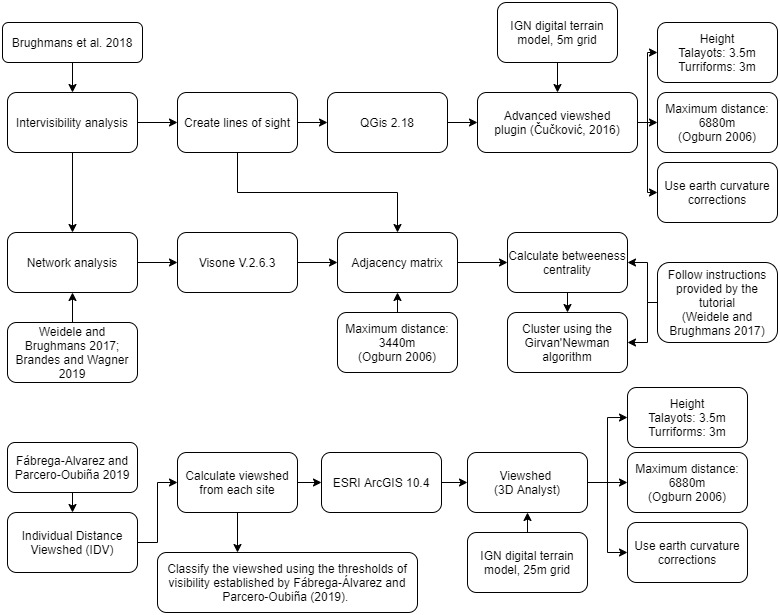
Two methodologies have been combined here to understand how sites connect through the landscape. First, to understand the visual connections between sites, the intervisibility between sites has been calculated. Intervisibility was calculated as the length of a line of sight between each architectural ensemble taking into ccount a theoretical height for each type of building, which is 3.5 m in the case of talayots and 3 m for stepped monuments and turriforms (Brughmans et al. Reference Brughmans, de Waal, Hofman and Brandes2018; Čučković Reference Čučković2016). Distance thresholds for short (1150 m), medium (3440 m) and long distance (6880 m) have been taken into account, following the visual acuity limits proposed by Ogburn (Reference Ogburn2006) and Higuchi (Reference Higuchi1983). Both intervisibility and visibility analysis were conducted up to the long distance limit (6880 m), while network analysis was conducted for the middle distance limit (3440 m) (Ogburn Reference Ogburn2006).
The connections between sites were analysed as a network, which has allowed us to examine the number of sites that connect with each one and its betweenness index, which is ‘the number of times a node acts as a bridge on the shortest path between two other nodes’ (Weidele & Brughmans Reference Weidele and Brughmans2017, 34). The betweenness index indicates which sites gather and redistribute the visual connections, therefore playing a more complex role in the visual network of each area. Also, the clustering of the network has been calculated using the Girvan Newman Clustering algorithm,Footnote 2 which hierarchizes the network based on the betweenness index of the edges. This allows us to see the structure of the visual connections and which sites develop a redistribution role in the visual network (Weidele & Brughmans Reference Weidele and Brughmans2017, 36).
Second, in order to approach the visibility between sites at a human scale, the Individual Distance Viewshed (IDV) has been calculated,Footnote 3 which explores the maximum distance at which a person walking can be recognized (Fábrega-Álvarez & Parcero-Oubiña Reference Fábrega-Álvarez and Parcero-Oubiña2019). In this case, it differentiates between a detection distance, in which the person is discernible from the background (2250–2100 m), and recognition distance, when the characteristics of the person can be recognized (1250–950 m). Also, at 600 m, the identity and behaviour of the person can be recognized, and at c. 225 m more details can be seen. Finally, at 60 m distance the individual characteristics of a person can be recognized (Fábrega-Álvarez & Parcero-Oubiña Reference Fábrega-Álvarez and Parcero-Oubiña2019). These distances allow us to reflect upon mobility and landscape at a human scale. Although the original study was conducted in areas with low vegetation, the authors also tested it in archaeological contexts where vegetation distribution is not known (Fábrega-Álvarez & Parcero-Oubiña Reference Fábrega-Álvarez and Parcero-Oubiña2019, 66). The studies conducted in Mallorca suggest a mosaic landscape, with areas of managed forest, alternating with open areas, with agriculture and pasture lands (Pérez-Jordà et al. Reference Pérez-Jordà, Peña-Chocarro, Picornell-Gelabert and Carrión Marco2018; Picornell Gelabert & Carrión Marco Reference Picornell-Gelabert and Carrión Marco2017; Picornell-Gelabert & Servera-Vives Reference Picornell-Gelabert and Servera-Vives2017; Servera-Vives et al. Reference Servera-Vives, Riera and Picornell Gelabert2018).
All the calculations regarding viewsheds and lines of sight were conducted through ESRI ArcGis 10.4 and Quantum GIS 2.18, using the advanced viewshed plugin (Čučković, Reference Čučković2016), while the visual networks were analysed with Visone V.2.6.3 (Brandes & Wagner Reference Brandes and Wagner2019). The digital terrain models of the National Geographical Institute (IGN) of Spain were used for the terrain information, using the 5 m grid for intervisibility and the 25 m grid for visibility calculations.
The northeast area of study
The first area of study is in the northeast of the island of Mallorca (see Figure 1), nowadays between the municipalities of Sant Llorenç and Manacor. It is a flat coastal area, delimited to the north by the Serra de Llevant mountains. At the centre of the coastal plain, in the site of Marina de Sa Punta, is a circular talayot with a height of over 3 m. In the same area, a double naviform, a Bronze Age structure, showcases an earlier occupation, and we know at least one more was dismantled in the 1980s (Rosselló Bordoy Reference Rosselló Bordoy1989). The nearby site of Sa Gatera is close enough that it falls within the limit of human visual recognition and is less than 15 minutes’ walk away (see Figure 2). The two sites are the only ones that have talayots not located in areas of visual elevation, and the viewshed from them is especially focused on their surroundings. The connection between these two sites, their location, and the community architecture present in each of them confers them a central position in the area. We do not know the exact use of each talayot, but the combination of types and its territorialization in one area allow for a complex differentiation of gathering places, possibly with different activities carried out in each of them.
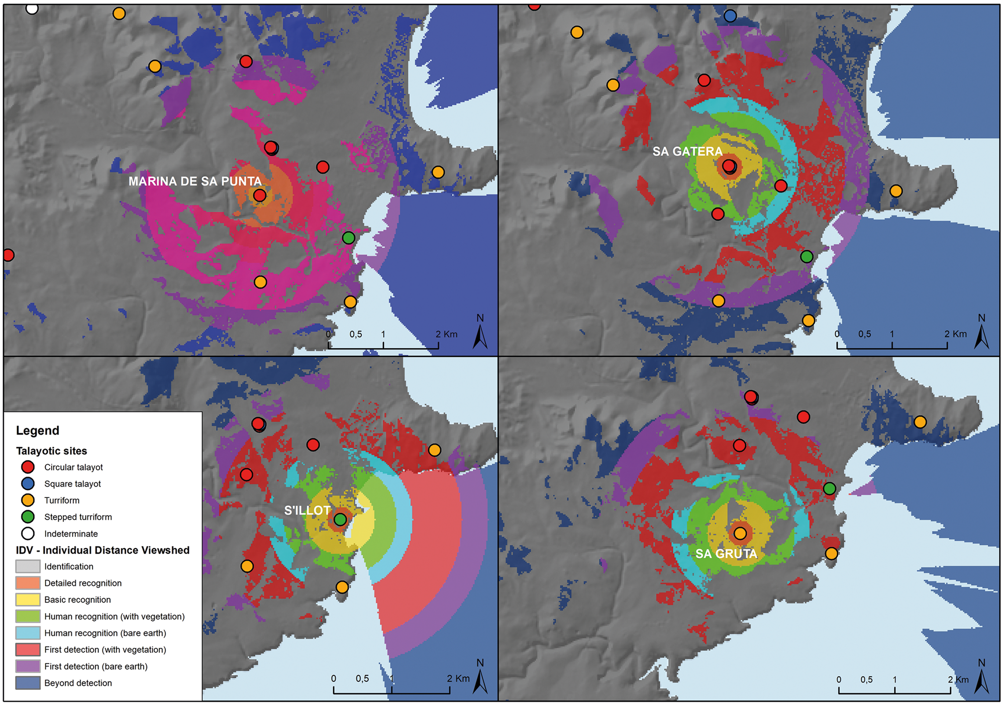
Figure 2. Individual Distance Viewshed (IDV) of the sites of Marina de Sa Punta, Na Gatera, S'Illot and Sa Gruta, in the northeast area of study.
Around these two sites, there is a complex network of intervisibility that spans along the coast and into the interior elevated area (see Figure 3). Along the coastline, Punta de n'Amer, S'Illot and Cala Morlanda present an important visual connection with the seascape. S'Illot showcases the transition between the Late Bronze Age and the Talayotic period. The first occupation of the site dates to the Late Bronze Age. However, the structures were heavily remodelled with the construction on top of them of a talayotic turriform (Font Rosselló & Valenzuela Oliver Reference Font Rosselló and Valenzuela Oliver2018; Frey & Rosselló Bordoy Reference Frey and Rosselló Bordoy1964; Rosselló Bordoy & Frey Reference Rosselló Bordoy and Frey1966). This connects the memory and the significance of the place to previous practices and gatherings. The closest evidence of Bronze Age habitat architecture is in Marina de Sa Punta, and in Sa Marineta, around 6.5 km from the coastline.

Figure 3. (A) Intervisibility between sites across the northeast area of study. (B) Network analysis with clustering calculated using the Girvan Newman Clustering algorithm. The area of each node is proportional to its betweenness index.
The significance of S'Illot, though, is in the persistence of the place, and its gradual transformation. Attached to the turriform is a habitat structure (Habitació 19) which is testimony to the use of this space during the Talayotic period (Font Rosselló & Valenzuela Oliver Reference Font Rosselló and Valenzuela Oliver2018, 36), although most of the site seems to have been built at a later date. It is located near the coastline and at the end of the ravine of Son Amer, and presents the only evidence of the exploitation of aquifers in the area, with the turriform sitting on top of a cave with freshwater (Cañigueral Reference Cañigueral1953, 249). Furthermore, its location along the coastline would potentially have allowed this site to be seen during coastal navigation, and presents an interesting viewshed across the maritime space (see Figure 2).
Along the coastline, there are two more sites with similar architectures and locations: the site of Punta de n'Amer, located in the peninsula of the same name; and the stepped turriform of Cala Morlanda, on the coastal cliff of Punta Moreia. The visual network (Fig. 3) connects Punta de n'Amer with the area of Na Gatera and Marina de Sa Punta, while Cala Morlanda has a closer connection with S'Illot. In both cases their location on the coastline as well as their visibility over the sea also suggest that they could potentially have functioned as a hinge between the land and the maritime space. The last stepped turriform of the area, Sa Gruta, presents a rather different location and relations. It is located distant from the coastline, but in the coastal plain area. It presents a preserved height of more than 3 m, and its prominence in the area directly comes from the architecture (Fig. 2), with a viewshed especially focused in the surrounding area. The combination of location and visual control makes it very similar to the site of Son Ferrer, in the southeast area of study.
The coastal network of sites is closed by a series of sites on top of hills, which connect this area with the interior of the island. Among them, Sa Punta deserves special mention, as this circular talayot visually closes the coastal area with a panoramic view over it and connecting with Es Puig-Ses Talaiasses, a stepped turriform also on top of a hill. This site opens the visibility to the interior area, and connects with other sites on top of hills, serving as a visual bottleneck between the coastal area network and the interior one (Fig. 3). The interior area, with sites on hilltops, would have created a tight connected landscape, where walking through it would potentially have been overlooked from one or more of these sites. This area could have been a connection between two different ones, or two different communities, a coastal one and one located in the interior of the area. The network shows a central area around the sites of Marina de Sa Punta and Na Gatera, surrounded by two arches of sites, one dotted along the coastline and another in the interior, with sites on top of hills, that in turn connect with others more inland (see Figure 3).
All in all, this network of sites creates a cohesive and connected area during the Talayotic period. A central living area can be traced across the coastal area, around sites such as Marina de Sa Punta, Na Gatera, Na Pol and S'Illot. The diversity in communal architecture at these sites, as well as the presence of more than one of these buildings in several sites, suggests a variety of practices and places where the community comes together, as well as a diversity of ways in how it gets territorialized in the landscape. Moreover, the limits of the network can be mapped as architecture demarcates and shapes them, through sites such as Punta de n'Amer, Cala Morlanda and Sa Gruta, all with turriform structures, or Sa Punta, with a talayot structure on top of a hill.
The southwest area of study
The second area of study is located in the southwest of the island of Mallorca in the peninsula of Santa Ponça (Fig. 1), which nowadays is part of the municipality of Calvià. This area is the most extensively researched and excavated of the three, mostly due to the research conducted by the University of the Balearic Islands in the framework of the Puig de Sa Morisca Archaeological Park (Albero Santacreu Reference Albero Santacreu2011; Calvo Trias Reference Calvo Trias2002; Calvo Trias & Aguareles Garcia Reference Calvo Trias and Aguareles Garcia2011; Galmés Alba Reference Galmés Alba2015; Reference Galmés Alba2021; García-Rosselló Reference García-Rosselló2010; Guerrero Ayuso Reference Guerrero Ayuso1982).
The main site in the area is Puig de Sa Morisca, in the western part of the peninsula, which has a long-term occupation, starting at the Late Bronze Age (c. 1300–800 bc). The excavation of Torre I showed occupation of the coastal hilltop (Albero Santacreu et al. Reference Albero Santacreu, Calderón Díaz, Calvo Trías, Gloaguen Murias, Calvo Trias and Aguareles Garcia2011, 311–13; Guerrero Ayuso et al. Reference Guerrero Ayuso, Calvo Trias, García Rosselló and Gornés Hachero2007; Salvà Simonet et al. Reference Salvà Simonet, Calvo Trias and Guerrero Ayuso2002), possibly in relation to the coastal network of sites across the islands, which could have been connected to coastal navigation systems (Calvo et al. Reference Calvo, Javaloyas, Albero, Garcia-Rosselló and Guerrero2011; Calvo Trias & Galmés Alba Reference Calvo Trias and Galmés Alba2018; Guerrero Ayuso et al. Reference Guerrero Ayuso, Calvo Trias, García Rosselló and Gornés Hachero2007). However, it is during the Talayotic period that a formal occupation of the hilltop was established, through the construction of a circular talayot on top of the hill (Torre III). The successive habitations of the space, especially during the Almohad period (1203–29) and in contemporary times, with its use as a military coastal battery, made it impossible to assess its use in Talayotic times (Albero Santacreu et al. Reference Albero Santacreu, Calderón Díaz, Calvo Trías, Gloaguen Murias, Calvo Trias and Aguareles Garcia2011, 321–5; Garcia Amengual et al. Reference Garcia Amengual, Guerrero Ayuso, Calvo Trias, García-Rosselló, Albero Santacreu and García Maas2010). However, in the exterior of the structure, a fireplace and pottery fragments have made it possible to date the occupation to c. 750–400 bc (Albero Santacreu Reference Albero Santacreu2011; Albero Santacreu et al. Reference Albero Santacreu, Calderón Díaz, Calvo Trías, Gloaguen Murias, Calvo Trias and Aguareles Garcia2011, 322). At the bottom of the hill, a series of structures reveal a habitat area, although it has not been excavated (Albero Santacreu et al. Reference Albero Santacreu, Calderón Díaz, Calvo Trías, Gloaguen Murias, Calvo Trias and Aguareles Garcia2011, 323–5; Calvo Trias Reference Calvo Trias2002; Guerrero Ayuso et al. Reference Guerrero Ayuso, Calvo Trias and Salvà Simonet2002). Just 500 m from this site, the talayot and turriform of Son Miralles could have been part of the same area of daily activities (Albero Santacreu et al. Reference Albero Santacreu, Calderón Díaz, Calvo Trías, Gloaguen Murias, Calvo Trias and Aguareles Garcia2011, 331, 329; Calvo Trias Reference Calvo Trias2002; Calvo Trias et al. Reference Calvo Trias, Quintana Abraham and Guerrero Ayuso2009; Guerrero Ayuso Reference Guerrero Ayuso1982; Vallespir et al. Reference Vallespir, Prohens, Orfila Pons and Merino1987).
In the mid-centre part of the peninsula, the stepped turriform of Son Ferrer dominates the flat area. The oldest occupation of this site is three funerary hypogea, dating from the Bronze Age (c. 1800–1500 bc). During the Late Bronze Age (c. 1100–850 bc), a structure was built on top of one of these hypogea, which was later rebuilt as a stepped monument (c. 900–700 bc) (Calvo et al. Reference Calvo, Fornés, Garcia, Iglesias and Juncosa2005; Reference Calvo, Garcia Rossello, Iglesias Alonso, Juncosa Vecchierini, Munar and Pomar2010; Calvo Trias et al. Reference Calvo Trias, Garcia Rosselló, Iglesias Alonso and Juncosa Vecchierini2006; Reference Calvo Trias, Garcia Rosselló, Molina, Albero Santacreu and Van Strydonk2014). In the area there are three more stepped turriforms, which have not been excavated. One, on the hilltop of Puig de Ses Rotes Velles (Albero Santacreu et al. Reference Albero Santacreu, Calderón Díaz, Calvo Trías, Gloaguen Murias, Calvo Trias and Aguareles Garcia2011, 329; Calvo Trias Reference Calvo Trias2002; Vallespir et al. Reference Vallespir, Prohens, Orfila Pons and Merino1987); the second, known as Sa Barraca de l'Amo, is located in the eastern part of the peninsula (Albero Santacreu et al. Reference Albero Santacreu, Calderón Díaz, Calvo Trías, Gloaguen Murias, Calvo Trias and Aguareles Garcia2011, 330; Calvo Trias Reference Calvo Trias2002; Guerrero Ayuso Reference Guerrero Ayuso1982), and the third is the Son Miralles stepped monument, near Puig de Sa Morisca. Moreover, during the Talayotic period, a series of sites on top of hills have been documented, such as the platform at Puig de Sa Celleta, or the structures on top of Puig de Saragossa and Puig del Rei (Albero Santacreu et al. Reference Albero Santacreu, Calderón Díaz, Calvo Trías, Gloaguen Murias, Calvo Trias and Aguareles Garcia2011, 331–332; Vallespir et al. Reference Vallespir, Prohens, Orfila Pons and Merino1987).
The intervisibility between these structures shows a net of visual connections that focuses on the western part of the peninsula (see Figure 4). Puig de Sa Morisca is the centre site of the network, with a very close connection with the area of Son Miralles. Ses Rotes Velles and Puig de Sa Celleta, located on top of hills, close the area on the north, while Son Ferrer and Barrca de l'Amo close the network to the south and west (Fig. 4). The betweenness index shows how Son Ferrer and Puig de Saragossa are the bridge between the eastern and western parts of the peninsula. Puig de Sa Morisca is the main site in the network, as it concentrates the most visual connections due to its location on top of the hill. It distributes the connectivity to the nearest area of Son Miralles, as well as to all the other sites around it, that surround the whole western part of the peninsula (Fig. 4). But its importance is not only in terms of the connections with other sites, but also its connection with the maritime landscape, especially due to its panoramic views across the bay of Santa Ponça, and the visual connection with the natural port of Sa Caleta (see Figure 5).
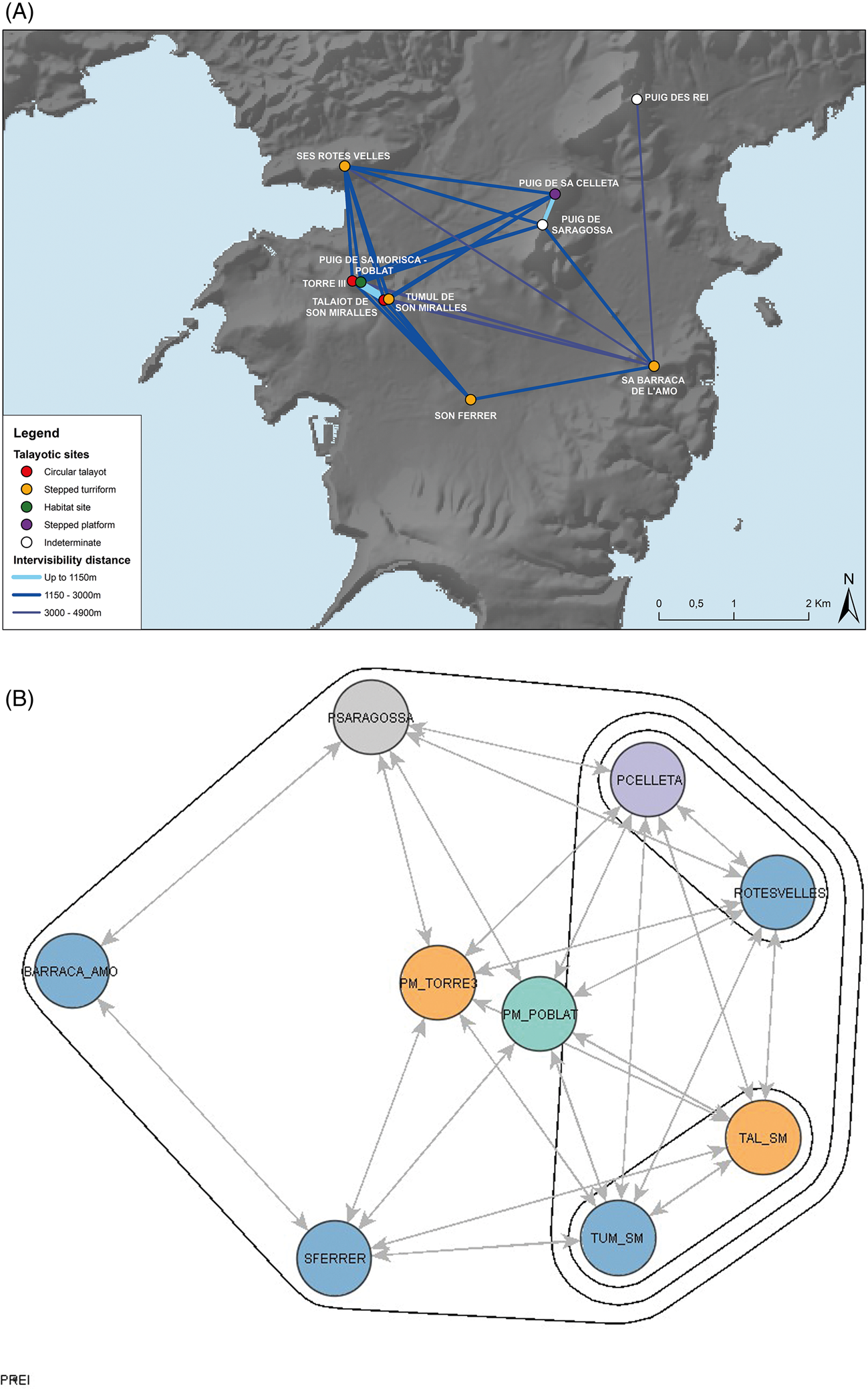
Figure 4. (A) Intervisibility between sites across the southwest area of study. (B) Network analysis with clustering calculated using the Girvan Newman Clustering algorithm. The area of each node is proportional to its betweenness index, and the intervisibility was calculated up to 3440 m distance.
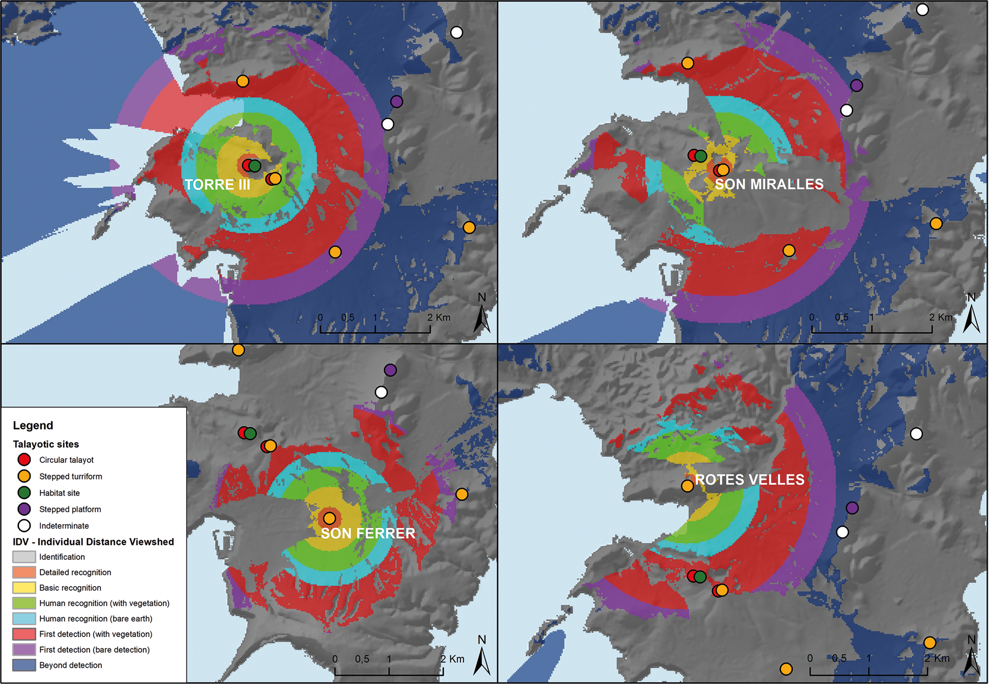
Figure 5. Individual Distance Viewshed (IDV) of the sites of Torre III (Puig de Sa Morisca), Son Miralles, Son Ferrer and Ses Rotes Velles, in the southwest area of study.
The importance of visibility over the bay and the maritime space is illustrated when comparing with the talayot of Son Miralles. The area of Son Miralles is less than 500 m away, and its proximity opens the possibility that both sites may have been used for day-to-day activities, like the one traced across the sites of Marina de Sa Punta, Na Gatera and Na Pol in the northeast area. Son Miralles and Puig de Sa Morisca are close enough to be in the basic recognition band of visibility in the Individual Distance Viewshed (IDV), which indicates that the visual relationship between these two areas allows possible recognition of the identity and behaviour of people as they moved around (Fábrega-Álvarez & Parcero-Oubiña Reference Fábrega-Álvarez and Parcero-Oubiña2019) (Fig. 5). The viewshed from each of them shows some differences. While Son Miralles has visual control focused on the interior of the peninsula, Torre III of Puig de Sa Morisca surveys a wider perspective, with visibility over the bay, the interior of the peninsula and the Galatzó valley. The different areas that could have been seen from these architectures, as well as the places from which they could have been seen, shows how they could have had different roles in the landscape, territorializing different social arenas.
As in the northeast area, a delimitation of the area through architecture can be observed. In this case, several stepped turriforms delineate the area, both located in flat areas as well as in elevations. The intervisibility network shows how sites such as Puig de Sa Celleta, Barraca de l'Amo and Ses Rotes Velles, characterised by the presence of stepped turriform structures, delimit and close the whole area. The IDV from these sites, such as Ses Rotes Velles (see Figure 5), show how they are slightly further away from areas that gather daily activities, such as the area of Puig de Sa Morisca – Son Miralles, falling in the limit of first detection (Fábrega-Álvarez and Parcero-Oubiña, Reference Fábrega-Álvarez and Parcero-Oubiña2019). Therefore, these sites act as a key place in the delimitation of the area but might have not been a daily scenario of community's activities. However, their location in areas that close the visual basins highlight their relational capacities in delineating a sensorial envelope (Frieman and Gillings, Reference Frieman and Gillings2007), an area where we can explore the perception of this network and this landscape.
Southeast area of study
The third area of study, located in the southeast of the island (see Figure 1), presents a rather different picture. In this area we are not analysing one cohesive community, but possibly the interaction between several of them. The analysis undertaken shows how the sites are grouped in three areas: the west coast, the east coast and the interior plain, closed by the southern elevations of the Serra de Llevant. Three distinct groups of sites can therefore be traced, each taking advantage of the different visual basins that divide the area.
The most cohesive group is the area around Talaies d'en Mosson (see Figure 6). The sites around this are distributed along the limits of the visual basin, in areas with certain visual prominence over its surroundings, and present a viewshed centred in the area surrounding the site and enclosed in this visual basin. Their location and architecture shape an area that is highly connected through it, and one that takes advantage of the visual landscape. Talaies d'en Mosson is located at the centre of this network. In this site we can currently locate two square talayots and two possible staggered turriforms, as well as some other undetermined structures. Nevertheless, the information that there were lime kilns in the area suggests that the site might have been more extensive (Mascaró Pasarius & Aguiló Adrover Reference Mascaró Pasarius and Aguiló Adrover1968, 110; Parera Reference Parera1924). It visually connects with sites that are mostly at a medium distance, except in the case of the circular talayot of Son Danús Vell, which is closer (Figs 6 & 7). These two sites lie at the centre of the network of intervisibility of this area, while the rest are distributed in two semi-circles around them, which translates into two different clusters of sites in the intervisibility network (see Fig. 6).
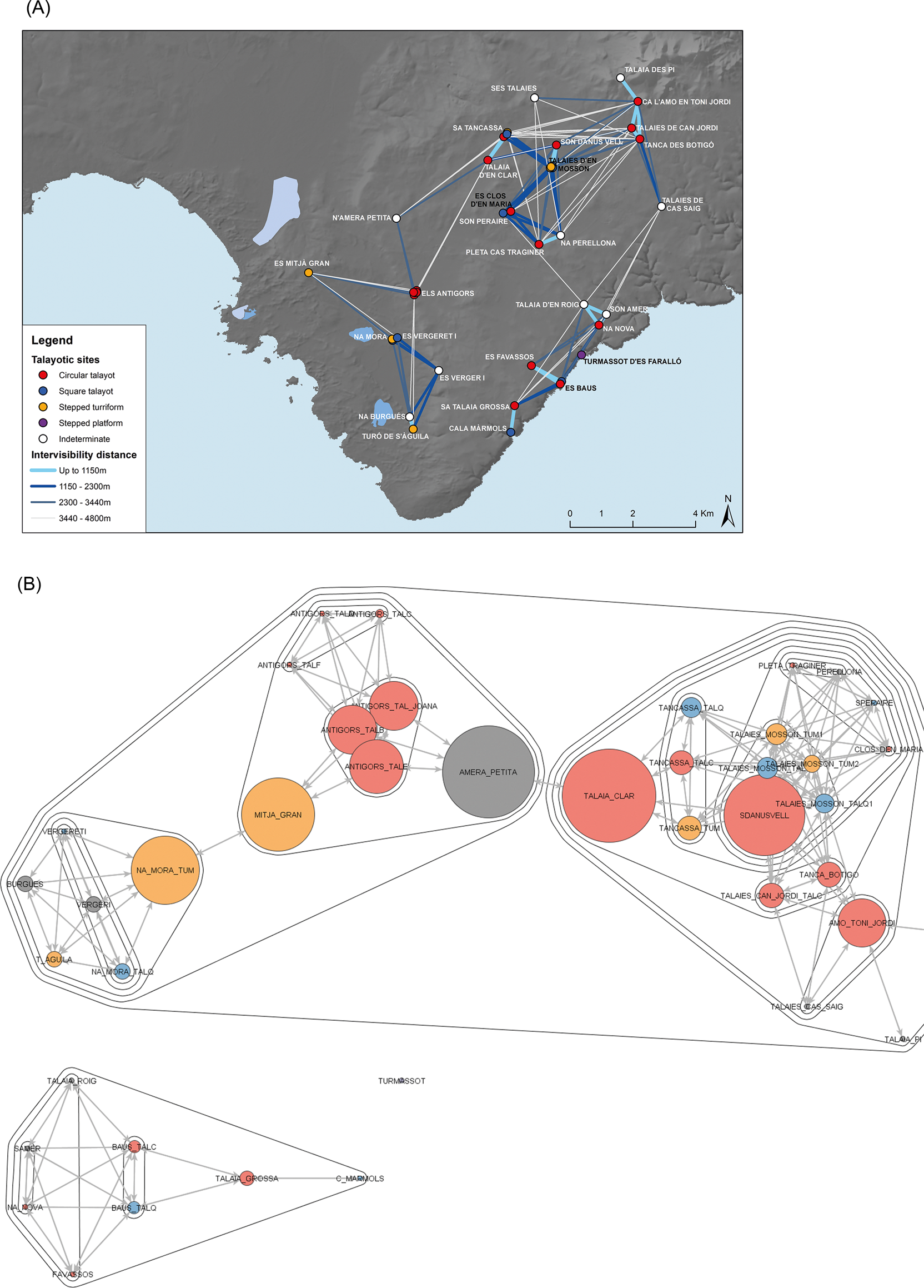
Figure 6. (A) Intervisibility between sites across the southeast area of study. (B) Network analysis with clustering calculated using the Girvan Newman Clustering algorithm. The area of each node is proportional to its betweenness index, and the intervisibility was calculated up to 3440 m distance.
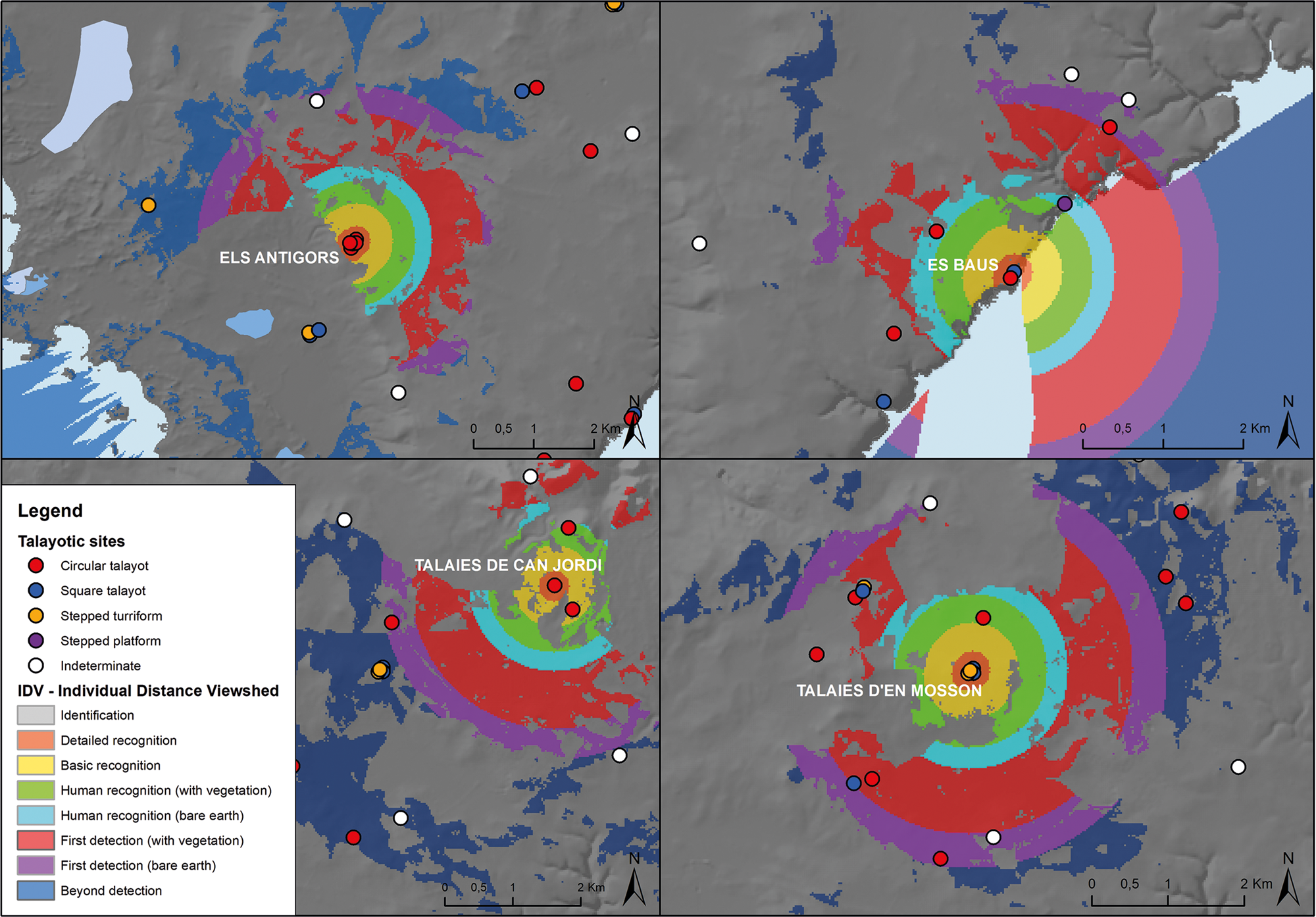
Figure 7. Individual Distance Viewshed (IDV) of the sites of Talaies d'en Mosson, Talaies de Can Jordi, Els Antigors and Es Baus in the southeast area of study.
In the southern part of the Serra de Llevant the sites are in an elevated area. We do know that both Talaies de Can Jordi and Tanca des Botigó were partially dismantled just a few decades ago, and so there were more communal structures in these sites (Aramburu-Zabala Higuera Reference Aramburu-Zabala Higuera2004; Reference Aramburu-Zabala Higuera2018; Carreras Escalas Reference Carreras Escalas2001; Parera Reference Parera1927). Therefore, their role in the intervisibility network could have been different. The IDV from them, as we can see in the case of Talaies de Can Jordi (Fig. 7), suggests a possible area of tight connections between this site, Tanca des Botigó and Ca l'amo en Toni Jordi; while their relationship with the centre of the area, that is with Talaies d'en Mosson, falls in the area beyond human detection. Therefore, although architecture might have been visible at that distance, people and daily activities would not have been.
On the other side of the visual basin, also connecting with Talaies d'en Mosson and Son Danús, are the talayots of Es Clos d'en Maria: Son Peraire, Na Perellona and Pleta de Cas Traginer. They all have similar locations, placed along the limits of the visual basing, with visibility over their surrounding area, within the limits of basic recognition and human recognition of the IDV. It is in this latter band that they connect with each other.
Moving to the western area, the site of Els Antigors concentrates a high number of communal structures. This site has six talayots, in varying degrees of preservation (Colominas Roca Reference Colominas Roca1915). The viewshed from each of these talayots is almost identical, however, except from Talaia Joana, the tallest one. Located on the interior slope of the elevation that conforms the Cap de Ses Salines, and over 5.5 m high, Talaia Joana is tall enough to have some visibility into the southwest visual basin. However, although it has enough height to see the eastern coastline, this would be at the extreme of the visual skyline, and so would not offer a detailed view. The assemblage of communal buildings nevertheless would have created a very distinctive profile of the site, possibly carrying some meaning to the people walking in the surrounding area. The visibility from the talayots is panoramic up to the band of human recognition (Fábrega-Álvarez & Parcero-Oubiña Reference Fábrega-Álvarez and Parcero-Oubiña2019), that is, there can be certain recognition or interaction between the people surveying the landscape from the talayot and those walking or engaged in different activities around it (see Fig. 7). The other sites in this western area are mostly located in flat areas and have viewsheds that run parallel to the coastline. Only the staggered turriform of Es Mitjà Gran (Colominas Roca Reference Colominas Roca1915) is located in a slightly visual prominent area, and the area seen from it is highly dependent on the height of the architecture, which nowadays is more than 3 m tall.
On the eastern coastline there is another group of sites that are not visually connected to the other groups analysed in this area (see Fig. 6). This might be due to missing links between them, or to the fact that we know that some of them were better preserved at the beginning of the last century than at the present time (Parera Reference Parera1925). The visual connection between the sites of Es Baus and Es Favassos (see Fig. 7), both with talayot structures, is at a distance that corresponds with the limit of human recognition of the Individual Distance Viewshed (IDV) that allows one to be able to distinguish basic anatomical shape and human movement (Fábrega-Álvarez & Parcero-Oubiña Reference Fábrega-Álvarez and Parcero-Oubiña2019, 63). Along this coastline, the sites of Sa Talaia Grossa and Na Nova, to the north, connect at a further distance, at the limit of first detection. Therefore, possible different areas of daily activities can be traced, one connecting Es Baus and nearby sites such as Es Favassos, and others up and down the coastline. In the case of Na Nova, it was probably part of a wider architectural ensemble together with the sites of Son Amer and Talaia d'en Roig, with this last site being dismantled for use in the construction of a road (Mascaró Pasarius & Aguiló Adrover Reference Mascaró Pasarius and Aguiló Adrover1968, 103).
The talayot of Na Nova displays a different relationship with the coastline from the other sites in this western coast, that can be compared to S'Illot, in the northeast area of study. Both sites are around 750 m from a potential anchorage point and in places with some visual prominence and visibility focused around the site. The poor state of preservation, or degradation due to the dismantlement of sites around Na Nova, such as Son Amer and Talaia d'en Roig, means it is not possible to trace the connections and relations of the area in the same way as can be done for S'Illot. Moreover, the links between the sites along the two coastlines and the interior area cannot be traced (see Fig. 6). Reports of several sites being taken apart to use the stone in different enterprises, such as the construction of roads or the railway, opens up the question of how many sites were deterritorialized and how recent this event was (Aguiló et al. Reference Aguiló, Coves and Carreras1979; Aguiló Adrover & Covas Tomàs, Reference Aguiló Adrover and Covas Tomàs1975; Aramburu-Zabala Higuera Reference Aramburu-Zabala Higuera2004; Reference Aramburu-Zabala Higuera2018; Colominas Roca Reference Colominas Roca1915; Mascaró Pasarius & Aguiló Adrover Reference Mascaró Pasarius and Aguiló Adrover1968; Parera Reference Parera1924).
A key difference between this area and those previously analysed is the high number of sites and the ensemble of communal structures in them. The combination of communal structures such as circular and square talayots as well as stepped turriforms shows a diversity of practices, but also the different ways in which they get territorialized. The different combinations show that there is a wide diversity of relations taking place in and around these buildings, highlighting their central places in the community's social arenas. It also demonstrates the difficulty of assigning one function to each type of building, because they can be found in a variety of locations and combinations. Therefore, the virtual diagram of the architecture can be actualized in different forms; we can see the differences and the diversity in the repetition, and each case possibly being distinct and unique (Harris Reference Harris2018; Normark Reference Normark, Cornell, Ersgård and Nilsen2018). Focusing on the relations that this architecture enables allows us to begin to understand their role in the community's landscape, but also why and how they endure, and how the assemblage that they territorialize changes.
Relational architectures and the configuration of the Talayotic landscape
Studies of settlement patterns during the Talayotic period have always emphasized that some talayots are in high places with wide visual control. They have also established a model with a central village in the middle and smaller, less important sites around it, which are the ones located in high prominent places (Aramburu-Zabala Higuera Reference Aramburu-Zabala Higuera1998; Gelabert Oliver et al. Reference Gelabert Oliver, Hernández-Gasch and Puig Palerm2018; Gili Suriñach Reference Gili Suriñach1995; Pons Homar Reference Pons Homar1999). The Talayotic settlement pattern was interpreted as the construction of a closed landscape, where mechanisms of survey were established with the location of sites around the main villages, and its position in high prominent places, with wide visibility and visual connection between them (Calvo Trias Reference Calvo Trias2009; Calvo Trias et al. Reference Calvo Trias, Quintana Abraham and Guerrero Ayuso2009; Galmés Alba Reference Galmés Alba2015; Galmés Alba & Calvo Trias Reference Galmés Alba, Calvo Trias, Anglada Fontestad, Riera Rullan and Martínez Ortega2017; Reference Galmés Alba and Calvo Trias2018).
However, the GIS analyses conducted show how this network of sites results from different configurations in each area. By focusing on the relations that each site enables we can see how each area presents a unique configuration of sites and social spaces. That is, the architecture and the space and relations that it highlights are actualized in a different way by each community. Therefore, there is a diversity in repetition (Beck Reference Beck2018; Harris Reference Harris2018; Normark Reference Normark, Cornell, Ersgård and Nilsen2018), each case being distinct and unique, displaying the potential variability of uses that these buildings have gathered. Even if they are part of the same architectural tradition, each one represents a different historical situation, and adds variation to that tradition.
Talayotic sites in elevated areas have been understood as the key component in the control of the landscape. They exist in each of the three areas of study, but both the architecture identified in them as well as their role in the network of sites are not necessarily the same. First, in the southwest area there is, on one hand, Torre III of Puig de Sa Morisca, in the elevation of the same name, as well as the nearby site of Son Miralles, with a talayot and a stepped turriform. In these cases, it seems that the centre of the network is in a prominent place, with a wide visibility around it. Around this centre are several other sites in prominent places, such as Puig de Saragossa, Puig de Sa Celleta, and at a lower altitude but still visually significant, Ses Rotes Velles and Sa Barraca de l'Amo. In the northeast area, the site of Marina de Sa Punta is the centre of the network that is also delimited by sites that are in prominent places, such as Sa Punta or Es Puig-Ses Talaiasses. Even in the flat coastal area Punta de n'Amer, Cala Morlanda or Sa Gruta could also have played a role as visually prominent sites, be this through its location in the visual landscape or through the height of the architecture.
In both cases several stepped turriforms delineate the network, either located in high altitude places, such as Puig de Sa Celleta or Es Puig – Ses Talaiasses, or in visually prominent places, as Ses Rotes Velles, Sa Barraca de l'Amo, Punta de n'Amer or Cala Morlanda. Moreover, in both cases the central site of the visual network presents a circular talayot, both in Puig de Sa Morisca and in Marina de Sa Punta. Both sites also show an occupation that begins during the Bronze Age (Albero Santacreu et al. Reference Albero Santacreu, Calderón Díaz, Calvo Trías, Gloaguen Murias, Calvo Trias and Aguareles Garcia2011; Garcia Amengual Reference Garcia Amengual and Riera Rullan2012; Guerrero et al. Reference Guerrero Ayuso, Calvo Trias, García Rosselló and Gornés Hachero2007; Rosselló Bordoy Reference Rosselló Bordoy1989).
In contrast to the other areas, in the southeast area there are two sites that form the centre of the network, Talaies d'en Mosson and Sa Tancassa, which present a complex aggregation of communal structures, with at least one stepped turriform at each one. Talaies d'en Mosson has at least two possible staggered turriforms and two possible square talayots in this period. Sa Tancassa, on the other hand, presents at least one stepped turriform, one circular and one square talayot. Unlike the other two areas, the limits of the visual basin are traced here by a series of sites with talayots, both circular and square. These are in visually prominent locations and create a network around these central sites. A similar configuration has been documented around the stepped monument of Mestre Ramon (Son Servera) (Gelabert Oliver et al. Reference Gelabert Oliver, Hernández-Gasch and Puig Palerm2018, 143).
Radiocarbon data available add to this narrative by showing that the stepped turriform structures were built c. 1100/1000 bc (Calvo Trias et al. Reference Anglada, Ferrer, Plantalamor, Ramis, van Strydonck and De Mulder2014; Gelabert Oliver et al. Reference Gelabert Oliver, Hernández-Gasch and Puig Palerm2018; Micó Reference Micó2005), so they are slightly older than talayots, whose construction can be dated to c. 1000–900 bc (Anglada et al. Reference Anglada, Ferrer, Plantalamor, Ramis, van Strydonck and De Mulder2014; De Mulder & van Strydonck Reference De Mulder, van Strydonck, Albertazzi, Muti and Saggio2021; Guerrero et al. Reference Guerrero Ayuso, Calvo Trias, García Rosselló and Gornés Hachero2007; Micó Reference Micó2005). Therefore, two possible different processes in the configuration of the talayotic landscape can be preliminarily traced: one, where the stepped monuments delineate the area of the community, as in the southwest and northern areas of study. In both these areas, the most central site in the network presents a Late Bronze Age occupation and later the construction of a talayot. The second is where the stepped turriforms act as a gathering place for the community and form the base for a convergent place. In the southeastern area of study, the central site of the network, Talaies d'en Mosson, is the only one that has a stepped turriform, while the sites around it are mostly talayots. Moreover, in this case, the central site has a variety of structures, which could highlight the role of this site as a place for interaction and possibly an array of communal activities and social arenas. A similar configuration, although with a central site with only one stepped turriform, can be seen in other areas of the island, such as around the site of Mestre Ramon (Gelabert Oliver et al. Reference Gelabert Oliver, Hernández-Gasch and Puig Palerm2018). Although we do not know the exact uses of each of these architectures, the connections between them, and the territorialization of communal social arenas through cyclopean architecture, provide a way to understand how they could have become places of social significance, of gathering and memories. Thus connecting architectures, understanding them as part of a wider assemblage, and not by themselves, is a way to approach the Talayotic landscape, encompassing variation and difference in it.
When examining the connections between sites, we can gain significant insight from viewshed and Individual Distance Viewsheds (IDV) (Fábrega-Álvarez & Parcero-Oubiña Reference Fábrega-Álvarez and Parcero-Oubiña2019) as it permits imposing a scale which is meaningful in terms of human and perceptive dimensions on previous studies that looked only at the mean distance between sites (Aramburu-Zabala Higuera Reference Aramburu-Zabala Higuera1994; Reference Aramburu-Zabala Higuera1998; Coll Conesa Reference Coll Conesa, Padró, Prevosti, Roca and Sanmartí1993; Gelabert Oliver Reference Gelabert Oliver2018; Gili Suriñach Reference Gili Suriñach1995; Pons Homar Reference Pons Homar1999; Salas Bruguera Reference Salas Bruguera1997; Salvà Reference Salvà and Rosselló Bordoy1992). The connection between sites and their nearest neighbour falls mostly between the bands of human recognition and first detection of the IDV. That is documented especially in the area around Talaies d'en Mosson and that around Marina de Sa Punta. In the peninsula of Santa Ponça, the orographic configuration of the area keeps most sites within the first detection band of the IDV during the Talayotic period.
Translating the distance between sites to these parameters allows us to grasp the sensorial envelope of these areas (Frieman & Gillings Reference Frieman and Gillings2007), giving a visual scale to it. It shows how even though the sites are close enough to see each other, they are generally located at a distance that although it allows recognition of human figures moving around the site and carrying out different activities, it does not allow their identification (Fábrega-Álvarez & Parcero-Oubiña Reference Fábrega-Álvarez and Parcero-Oubiña2019). This understanding of the human scale of the distance between sites allows consideration of the visibility and connection between sites, which has previously been characterized as visual control (Calvo Trias Reference Calvo Trias2009; Calvo Trias et al. Reference Calvo Trias, Quintana Abraham and Guerrero Ayuso2009; Galmés Alba Reference Galmés Alba2015; Galmés Alba & Calvo Trias Reference Galmés Alba, Calvo Trias, Anglada Fontestad, Riera Rullan and Martínez Ortega2017; Reference Galmés Alba and Calvo Trias2018). Even though there is a visual connection between sites, as we have ascertained through intervisibility and network analysis, we should nuance our understanding of it. It is not a visual connection that can create a sense of survey or control from one site to another, but rather a gentler one. It is one that allows for a sense of shared landscape, a way to see the community across it. And it would have allowed walking around always seeing one or another monument.
However, focus on the relations between sites allows us to understand them as an assemblage. The main goal of this research has not been to understand these buildings in themselves, as the archaeological data available does not allow that degree of interpretation. Instead, the main goal has been to understand Talayotic architecture as an assemblage, and this perspective has allowed two things. First, to break from rigid models of settlement pattern, and instead understand the difference in repetition, how each area is unique and at the same time part of the same tradition (Beck Reference Beck2018; Harris Reference Harris2018). This shows how communities emerge through relations, and how tracing these relations across the landscape can show different paths in the configuration of a social arena. Second, it allows us to focus not on the activities that each building gathered, but the relations it enabled and territorialized across the landscape. Therefore, we did not try to associate a type of building with a function drawn from an archetype, but rather to understand them as a gathering of relations. This has enabled us to see how each building played a different role in the network, and how each is unique, and draws its meaning from the relations that conform it as a gathering place.
In the end, architecture is the creation not only of a place, but also its relations. It provides the means to explore the connections between places, communities, material culture, landscapes, and beyond. Throughout this study we have explored how the architecture shaped and gave meaning to the landscape and have shown how we cannot understand the buildings by themselves, but they must be put into the wider set of relationships that they conform. Through a combination of GIS-based analyses we have shown how different communities used architecture in similar yet different ways; how these buildings provided an enduring place of gathering and how the social and political arenas that they grounded changed over time. The assemblage of sites across the landscape showcases how visual connections played a central role in the relations between sites, through both their location but also through the architecture itself.
The differences and similarities between communities show the different ways in which each one of them constituted their landscape, and how it changed over the centuries. It highlights the need for understanding architecture as a process, not as a static element, and its capacity for being part at the same time of multiple assemblages, of multiple identities and social arenas (Beck Reference Beck2018; Bille & Sørensen Reference Bille, Sørensen, Bille and Sørensen2016; Crellin Reference Crellin2020; Fowler Reference Fowler2017; McFadyen Reference McFadyen, Bruno and Thomas2008). Understanding architecture as an assemblage has allowed us to explore its relational capacities, the variations within each typology and the different processes of change that are recorded through it. It shows how architecture is not a representation of the community, but a part of it. It constitutes an integral part of the assemblage that encompasses practices, identities, memories, objects, humans, landscapes and others. Also, by focusing on the relations, we have seen how communities emerge, how we can trace them through these connections. Moreover, it allows us to understand how each community was both unique and part of the same historical processes: how they connected and interacted across the island, each making sense of their own assemblage and landscape. And so, thinking or conceptualizing these buildings as assemblages allows us to highlight not what they are, or what they represent, but the relationships that they enabled, both in the past and in the present, as they still stand and are even now part of a shared and changing landscape.
Acknowledgements
This study was supported by the R&D project Movilidad y conectividad de las comunidades prehistóricas en el Mediterráneo occidental durante la prehistoria reciente: El caso de las Islas Baleares (PID2019-108692GB-I00), funded by the Ministry of Science, Innovation and Universities (Spanish Government). This study also received support from the R&D project Comunidades indígenas en el sudoeste de Mallorca en la Edad del Hierro, financed by Consell de Mallorca. Subvencions per a la recerca d'arqueologia i/o paleontologia (54512). Alejandra Galmés was funded by the FPU contract (Formación del Profesorado Universitario, FPU14/01800) awarded by the Ministry of Education, Culture and Sports (Spanish Government). Currently she is funded by the NextGeneration EU funds (Plan de Recuperación, Transformación y Resilencia) through the Ministry of Universities (Postdoc Margarita Salas) via the University of the Balearic Islands. We would like to thank D. Albero (lecturer at the University of Balearic Islands) and María Calderón (Department of Cultural Heritage, Calvià Council) for their information about the archaeological sites from Calvià. We would also like to thank Max Fancourt for proofreading this paper.
Supplementary material
Supplementary materials may be found at https://doi.org/10.1017/S0959774321000627


 Open access