


In ancient times people were few, but birds and beasts were many
上古之世人民少而禽獸衆 Han Feizi 韓非子 Footnote 1Introduction
A few thousand years ago the forests, grasslands, and wetlands of the Yellow River Valley were home to an enormous diversity of wildlife. The spread of agricultural societies transformed these ecosystems so thoroughly that the only places one can now find terrestrial wild animals in North China are high mountains. The region's agrarian landscapes are so old that when people imagine its “natural” state they are more likely to picture preindustrial farming villages than oak forests or herds of deer. North China is among the most polluted places on earth, which makes it easy to overlook the fact that it became a center of civilization precisely because of its natural fertility and biodiversity. The success of agricultural societies in the region caused deforestation, overhunting, and habitat fragmentation, environmental issues now widespread globally, but not normally associated with the Yellow River Valley, whose environmental problems have progressed beyond damaging the natural environment to damaging the health of its human inhabitants. While we often associate environmental issues with science, it is up to historians and archaeologists to unravel the long and complex transformation of China's landscapes.
The first step in doing this is to reconstruct the environments of the core regions of Chinese civilization before humans transformed them. This paper synthesizes the outpouring of recent research on the climate and natural ecology of Shaanxi's Guanzhong 關中 Basin. As the capital of ancient China's empires, the Guanzhong occupies a place in Chinese history comparable to that of Rome in the West: a place that seemed like the center of the world for many centuries. Because of that, it has received more attention from scholars than most other parts of China. The name Guanzhong, which means “within the passes,” refers to the mountain passes that made it easy for whoever controlled the basin to keep out invading armies.Footnote 2 The combination of fertile farmland and natural defenses made it a perfect place from which to found an empire. As Ban Gu wrote of the Guanzhong, “with its shoots of flowers and fruits it has the highest fertility of the Nine Provinces. With its barriers of defense and resistance, it is the safest refuge in the world. Therefore, its bounty filled the six directions, and thrice it became the Imperial Domain” (華實之毛則九州之上腴焉。防禦之阻則天地之隩區焉。是故橫被六合三成帝畿。).Footnote 3 But what was the nature of the region before it became the prosperous capital of East Asia's greatest empires?
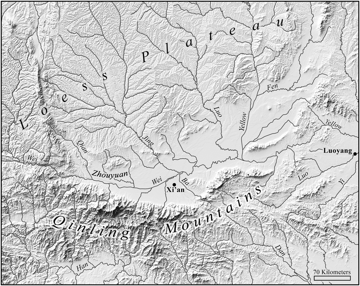
Map 1. The Guanzhong Basin and surrounding regions with the Zhouyuan and the modern cities of Xi'an and Luoyang indicated. Thanks to Lynn Carlson for making this map.
Much of the English-language scholarship on early China concerns the writings of the elite men who wrote most of the extant texts. This can give the impression that North China was then like it is now: all people, no wildlife. But when we look for it we can find abundant evidence that people in early China were surrounded by wild plants and animals. While Neolithic societies did impact their environments, they did not dominate them, and even in the Bronze Age human settlements were still novel ecosystems surrounded by wild nature. This is clear from the abundant references to hunting large wild animals in Shang oracle bones and the biodiversity apparent in the Book of Odes.Footnote 4 But over the centuries agricultural societies expanded and eliminated the habitat of other large mammals so that by the mid-Han Dynasty the lowlands of the Yellow River valley were home to over forty million people (see Map 2). The forests, wetlands and megafauna had been replaced with farms and livestock. The phrase “mountains and wetlands” shan ze 山澤 became a standard phrase for wild places because all the flat dry land was being farmed. Similarly, references to hunting wild animals during the last three centuries b.c.e. tend to refer to aquatic animals or migratory birds, evidence that the only remaining wildlife in lowland North China was found in places too wet to farm.Footnote 5 There was still plenty of wildlife in the sparsely populated Yangzi Valley, but the only places in lowland North China with large wild mammals were in imperial hunting parks.Footnote 6Footnote 7

Map 2. Registered Population of the Han Empire in 2 c.e.; each dot represents 25,000 people. By this time humans had replaced the natural ecosystems of the core population regions with farmland, especially in the plains of the east, the Guanzhong, and Chengdu in the southwest. The rectangle encompasses the area depicted in Map 1.
Because humans transformed these ecosystems so early, non-textual sources are essential for reconstructing North China's natural environments.Footnote 8 In recent decades the Chinese government has poured funds into the sciences, dramatically increasing the quality and quantity of scholarship on early China's environments. But synthesizing this information is difficult because each field explores different questions. Scientists often explore questions that are only related to human history in a very general sense, such as how the earth's climate system works, but nonetheless produce useful data on specific times and places. They are also more likely than archaeologists to explore questions that are not centered on humans. Generous incentives from China's government to scholars publishing in English-language science journals are pushing archaeologists to put more emphasis on climatic or ecological questions, greatly improving the quality of relevant archaeological research. Unfortunately, this is especially true of archaeologists working on periods before texts, while archaeologists of the historical period in China have mostly maintained their text-centered (and thus urban elite-centered) paradigm.Footnote 9 Little multidisciplinary archaeological research has been done on the natural and human ecology of the historical period, roughly the past 3000 years. But the enormous variety of scientific data that has been produced on the natural environment of North China has superseded much existing scholarship and allows us to understand the ecology of early China better than we did before.
This scientific data is important because of the ambiguity of textual evidence. For example, there are many dozens of plants and animals mentioned in the Odes, many of which are common species like millets, hemp, and horses. This makes them invaluable for reconstructing the ecology of human society at this time.Footnote 10 However there are dozens of rarer names that cannot be identified with any certainty, and when we look into the commentaries we find layer upon layer of guesses.Footnote 11 Modern work on this topic is quite useful, but those that equate each ancient plant or animal name with a modern scientific one cannot be taken seriously because 1) both modern scientific taxonomic divisions and ancient Chinese taxonomies are somewhat arbitrary, 2) we have no way of being certain about the meaning of rarely used ancient words, and 3) some of the names used in early texts never referred to single species, but were general categories like “oak” or “shrike.”Footnote 12 Texts are even less useful for reconstructing climate.Footnote 13 But I would emphasize that although textual evidence has limited value for reconstructing ancient ecologies and climates, it is incredibly valuable for understanding the relationships between people and their environments, and a lot of work remains to be done on that topic.
Given that this paper employs evidence from many different time periods, it is worth explaining why I think that evidence from any period in the past 10,000 years is relevant for this topic. The rise of agrarian civilization over this period has been possible because of a remarkably stable climate. Whereas the earth's climate had shifted over 10° C between 20,000 and 10,000 years ago, it has only fluctuated by about 2° C since then. What this means is that climatic changes over the past 10,000 years have been a relatively minor driver of ecological change. It was the expansion of agricultural societies that has transformed the biosphere. Without humans, the ecology of the Yellow River valley would not have changed very much over the past 10,000 years, which is, after all, just an instant in geological time. For this reason, any evidence on the region's natural ecosystems from the past 10,000 years can be used to reconstruct what it would have been like throughout this period if people had not transformed it. Some of the most important evidence comes from the remaining flora and fauna of the region.
The Guanzhong basin sits between the dry Loess Plateau to the north, the once-forested lowlands to the East, and the still-forested Qinling mountains to the south. Its natural ecology once had something in common with all these regions, which we will review shortly. Before we do it is worth briefly describing the region's current agroecosystems. The most common plants growing in the region today are agricultural ones like wheat, maize, cotton, apples, pears, plums, peaches, and apricots, and weedy ones like grasses, asters, and Artemisia. Most of the non-agricultural trees grown in the area now are fast-growing ones like paulownia and poplar; these have replaced a much larger array of native slow-growing trees.Footnote 14 Shrubs that grow wild across the region include wolfberry (a.k.a. goji), chaste tree (Vitex negundo), and various species of Rubus (the genus of raspberries and blackberries), but even these are mostly useful for humans, further evidence that people have been modifying vegetation for millennia.
The situation is the same with animals. The only large mammals now common in the Guanzhong Plain are humans and pigs. Chickens and dogs are also common, and people herd sheep, goats, and cattle on the Loess Plateau to the north. Various small wild animals have adapted to agricultural settlements and are now key parts of the human ecosystem, including sparrows, pigeons, hares, rats, and several other species of smaller rodents.Footnote 15 Bats form a symbiotic relationship with humans, eating insects that feed on crops while living in the eaves of houses.Footnote 16 And there are a whole host of insects, bacteria, viruses and other small creatures that also specialize in living in human societies and human bodies.
But this article focuses on the environment that humans did not create, the one that would still exist if humans had not transformed it. My main goal is to help scholars working on North China understand the environment of their study region, but I also hope to make clear just how much humans have transformed our environments and how long we have been doing so. While scholars in various fields have debated whether the Anthropocene began with industrialization or the nuclear age, the old-world centers of civilization had been transformed by human activity long before then.Footnote 17
More concrete than the debates on the Anthropocene are those on the native ranges of plants and animals. Because of the lack of earlier data, scientists tend to take the world explored by biologists in the eighteenth to twentieth centuries as the baseline against which the current ranges of species are evaluated, essentially treating the distribution of each species at that time as their natural ranges.Footnote 18 But China's lowlands were thoroughly anthropogenic ecosystems by then, home to hundreds of millions of people.Footnote 19 Understanding China's natural environments is thus a historical problem, a research topic for which the skills of historians and archaeologists are essential.Footnote 20 And studying how people transformed the natural ecosystems of North China's plains and valleys into farmland is a subject that can only be addressed by scholars of early China because it is a process that was mostly complete by the Han Dynasty. This article is divided into four sections, on land, climate, plants, and animals.
Land
The landforms of the region are the stage upon which human history has played out: humans have transformed the soils, waters, and the biosphere, but our impact rarely extends more than a few meters below ground, the depth of canals, ditches, and tombs. We will therefore begin with the basic geology of the region. From west to east, the Yellow River Basin can be divided into upper, middle, and lower sections, the first of which includes the northeastern Tibetan Plateau, where the river originates, and the northern Loess Plateau. The middle Yellow River Valley includes the Guanzhong and Fen River basins, whose rivers empty into the river before it flows eastwards through the region around Luoyang, Henan, which is traditionally known as the “Central Plain.” The lower valley is the North China Plain. This work concerns the middle Yellow River Valley, in particular the Guanzhong Basin, which is the lower section of the Wei River valley.
The Guanzhong Basin is composed of the 12,000 km2 Guanzhong Plain and the mountains that surround it. The plain is situated at around 34° latitude, similar to Damascus and Los Angeles, and stretches 300 km from east to west.Footnote 21 The elevation of the plain drops from 600 m above sea level in the west to 330 m at the mouth of the Wei River. The west receives more precipitation, while the east is warmer.Footnote 22 Because of its poor drainage and high evaporation rate, which caused salinization, much of the central and eastern Guanzhong could not be farmed until Qin began to drain and irrigate it in the mid-first millennium b.c.e. Before this, during the entire Neolithic and Bronze Age, the best farmland in the Guanzhong was found in the sloping lands along the edges of the basin, especially the Zhouyuan (the “Zhou plain”) at the western end of the basin and the areas between the foothills of the Qinling and the Wei River (see Map 1). Humans have been modifying the ecology of these regions for thousands of years.
Hills and mountains surround the plain on all sides except the east, where the mighty Yellow River forms its boundary. To the south and southwest, the towering, forested Qinling 秦嶺 Mountains rise abruptly from the plain. Most of their peaks are around 2000–3000 m and the highest peak, Mt. Taibai 太白, reaches 3767 m. The rounded hills and mountains north of the Guanzhong vary in height; some of them steeply overlook the plain, while in some areas the plain rises gently into the Loess Plateau. The Loess Plateau stretches for hundreds of kilometers to the north of the Guanzhong, and mostly lies between 1000 and 1600 m in elevation. It is characterized by loess soils tens of meters thick that are mostly composed of fine silt that have been blown in by storms from the northwestern deserts for over two million years. Loess is easily eroded during heavy summer rains, and erosion has created the distinctive landscape of the plateau, which is composed of gently sloping plains separated by deeply eroded gullies. The soils of the Guanzhong and other valleys in the region are mostly composed of loess that has been eroded and redeposited by water, and then modified by millennia of farming.
The Wei River flows through the Guanzhong from west to east. Many small rivers feed into it from the Qinling, but its largest tributaries, the Jing 涇 and Luo 洛 Rivers, flow from the north.Footnote 23 The Wei, Jing, and Luo all drain the Loess Plateau, and thus have high silt content and highly seasonal variations of flow.Footnote 24 The Wei River annually carries about six hundred million cubic meters of sediment, half of which comes from the Jing River, one third from the Wei River above Xianyang, and one sixth from the Luo River.Footnote 25 This gives some idea of the current scale of erosion in the loess area. The Luo enters the Wei River just above its confluence with the Yellow River in a sandy area that has been characterized by shifting rivers and lakes through much of the historic period.Footnote 26 While the increase of grazing due to human activity has surely increased erosion substantially, the loess would erode easily even without human impact. While some have argued that people began calling the Yellow River “yellow” in the Han Dynasty because of increased erosion, it has probably been yellow as long as humans have been observing it, at least during the rainy season.Footnote 27
The Qinling Mountains catch the moisture from clouds moving inland from the ocean, casting a rain shadow to the northwest. The mountains are thus covered in lush forests, but leave the Guanzhong and Loess Plateau dry. Since the Qinling's vegetation holds sediments, the numerous small rivers that flow northwards from the mountains into the Guanzhong have much cleaner water and a more regular flow than those north of the Wei River. This water supply is a main reason why so many rulers chose to situate their capitals in the Xi'an region rather than north of the river, and why it has remained the region's largest population center ever since.Footnote 28 The Qinling's rivers were even more reliable in ancient times, before people cut down the trees in the mountains and caused erosion that raised the levels of the riverbeds.Footnote 29 The wide rocky floodplains of the rivers that descend from the high Qinling in the western Guanzhong are evidence of violent floods, and make clear that these small rivers can become mighty torrents during spring thaws and summer rains.
Geological History
The land now called China was formed by the accretion of previously separate landmasses through plate tectonics, a history revealed in the Qinling, which connects the North China craton and the South China plate. The North China craton, which underlies the Loess Plateau, first formed around two billion years ago and remained stable for hundreds of millions of years.Footnote 30 Later, three separate tectonic plates successively ploughed into the southern end of the North China craton, depositing the rocks from which the Qinling later formed. The first of these was a chain of islands, the second a single large island, and the third was the South China plate, until then a separate continent.Footnote 31 The Chinese tradition of considering the Qinling the divide between North and South China thus happens to correspond with the region's geological history. Beginning over 50 million years ago the Indian subcontinent began to plough into the Eurasian mainland, causing the ongoing rise of the Tibetan Plateau and the mountains of Western China, including the Qinling.Footnote 32 The rise of these mountains blocked the northward movement of rainfall, creating the deserts and arid regions of Inner Asia. The whole region remains geologically active and is subject to powerful earthquakes.Footnote 33
The pressure that pushed the Qinling upwards forced the area to its north downwards, forming the Guanzhong Basin, into which rivers flowing from the surrounding mountains have deposited sediments several kilometers deep.Footnote 34 The Yellow River once flowed from west to east through the Guanzhong, but tectonic forces pushed up the Loess Plateau region and forced the river northward around the Ordos Plateau so that it now passes the Guanzhong from north to south.Footnote 35 Similar forces lifted the rocks to the east of the Guanzhong sometime after five million years ago, blocking the Yellow River and flooding the lower Wei and Fen valleys to form Paleo Lake Sanmen. Between 1,500,000 and 150,000 years ago the Yellow River gradually cut through the rock, creating the Sanmen Gorge (Sanmenxia 三門峽) and draining the lake.Footnote 36 Scattered saline lakes remained in the Eastern Guanzhong until recent centuries.Footnote 37 Many of the historical record of water bodies in the Guanzhong refer to ponds and lakes in imperial pleasure grounds, and we cannot be sure if these were built by people or not.Footnote 38
The climate has also shaped the region's physical geography. The earth's climate has been gradually cooling for over 50 million years, and the current geological period, known as the Quaternary, is a cold period in the earth's history. It is composed of long periods of glaciation followed by shorter interglacials, a cycle caused by regular wobbles in the earth's pivot.Footnote 39 The last glaciation ended around 18,000 years ago, after which the climate warmed. Geologists divide the Quaternary into two epochs, the Pleistocene (2,500,000–11,600 years ago) and the Holocene, the current interglacial period that began 11,600 years ago. The only reason the Holocene is designated as a separate epoch, unlike other interglacials, is that it happens to be the interglacial in which these geologists live, so it is useful to have a name for it. Since the Holocene is precisely the period in which human agricultural societies have come to dominate the earth's biosphere, and now affect its climate, one might argue that it should simply be renamed the Anthropocene. The Holocene has had an unusually stable climate, and this stability has been an essential factor in the rise and persistence of agricultural civilizations around the world. We cannot expect this stability to last another 10,000 years.Footnote 40

Figure 1. 420,000 year temperature reconstruction from the Vostok ice core, Antarctica.
As climates cooled, the amount of water evaporating from the ocean decreased, which reduced the amount of precipitation that fell on land and caused the deserts and steppes of Inner Asia to expand. As vegetation cover shrank and left more soil exposed, storm winds picked up loose silt, known as loess, and deposited it across North China. Wind can only carry a certain size of particle (0.005–0.1 mm): larger particles are too heavy to fly while smaller ones tend to stick together as clay, which makes loess remarkably uniform in texture.Footnote 41 Two million years of dust storms have deposited loess tens of meters deep across the 600,000 km2 Loess Plateau, and in many places it is over a hundred meters deep. Shallower loess is found across a much larger area of North China. As anyone who has lived in North China knows, wind-storms continue to deposit loess.
As the Pleistocene climate swung between cold, dry glacial periods and wetter interglacials, vegetation zones migrated north and south. The wetter conditions of interglacials allowed more plants to grow, which formed topsoil. The alternating thick layers of beige loess deposited in colder periods and thin layers of dark interglacial soils are easily visible in vertical cuts in the loess soils of the Guanzhong, as drawn in Figure 2.Footnote 42Footnote 43

Figure 2. Schematic north–south cross section of Guanzhong landforms. This figure is vertically exaggerated: in reality the terraces are wide and relatively flat. The loess tablelands to the north (left) would have been vegetated with grasses and dry-tolerant herbs, as would many of the terraces and “possible dry edges.” Trees grew in wetter areas like gullies, floodplains and terrace edges. Image by Yijie Zhuang.
North Chinese civilization has flourished because of the abundance of fertile loess: despite thousands of years of erosion, there is always more soil to farm, and its texture makes it quite easy to work. It is also fertile. Unlike soil eroded from a single base rock, which may be rich in some nutrients and weak in others, loess comes from a huge area and tends to contain most trace elements that are essential to the growth of plants, though it rarely contains all of them, so crops still benefit from fertilizers.Footnote 44 The soils in the plain are composed both of loess deposited by wind and loess eroded and redeposited by water. Higher precipitation in the southern loess region (including the Guanzhong) leads to increased plant growth and animal activity, which transforms the soil and makes it heavier and less porous than the loess to the arid northwest.Footnote 45 The Guanzhong's topsoil has also been transformed by thousands of years of farming.Footnote 46
The natural vegetation of the region reflected the availability of water. Loess soils mostly consist of silty loam and silty clay loam, which are quite porous and drain quickly so that soil moisture is lost quickly.Footnote 47 Because of this, and high evaporation rates, less water is available to plants than we would expect from the amount of precipitation the region receives. There are also significant differences in water availability across the Guanzhong.Footnote 48 Loess platforms with well-drained soils and deep water tables comprise about 40 percent of the plain. These relatively dry areas would have supported shrubby grassland with scattered trees, and they were too dry to reliably support non-irrigated farming. There is more water along the edges of the mountains to the north and south, where spring water emerges and the water table is closer to the surface. This water would have supported some of the region's densest woodlands, but also made this the best farmland, and farmers began to cut or burn these forests thousands of years ago.
Loess is easily eroded by torrential summer rains, and gullies have been forming in the loess region throughout its existence, something that has increased as humans and their livestock have destroyed vegetation.Footnote 49 While the Guanzhong plain is not as eroded as the Loess Plateau to the north, historical geographer Shi Nianhai showed that it has also been eroded. For example, the Zhouyuan was more or less a single plain in the Zhou period, but is now a series of plains divided by gullies. His clearest evidence came from the Chengguo 成國 canal which, when it was built around 100 b.c.e., crossed a river that now flows 30 meters lower than the level of the canal. This proves that the gully has eroded that far downwards in two millennia.Footnote 50
Climate
Human civilizations have flourished in a period of remarkable climatic stability. Over the past 10,000 years the earth's climate has only fluctuated by about 2°C and the sea level has been relatively stable, in marked contrast to the previous 10,000 years, when temperatures increased by 10° C and the seas rose 100 meters.Footnote 51 While historical climatic events like the Little Ice Age may have played major roles in human history, in a long-term planetary perspective they were just minor regional fluctuations.Footnote 52
In general, short-term events like droughts, storms, and cold spells are far more dangerous to human societies than slight changes in average temperature or precipitation. But, with the exception of the sediments deposited by major floods, currently available paleoclimate records only record such long-term trends. This is significant because there is no reason to expect prehistoric humans to have had any trouble adapting to minor climate changes that occurred over decades or centuries. To correlate written records of pre-imperial history with specific climate events we will have to wait for higher resolution data. Annual tree-ring records, for example, can reveal which years had more or less rain in a specific place, but scholars have yet to do the painstaking work of comparing the rings on archaeologically excavated timbers in China. Data on the changing distribution of archaeological settlements can be meaningfully compared with climate data, though at present this does not reveal any simple correlations between changes in climate and settlement distribution.Footnote 53 Those seeking to use climate to explain human history must find evidence that those climatic events affected humans, not merely assume that a climate event must have been the cause of a historical event that occurred around the same time.Footnote 54
East Asia's climate is dominated by the annual cycle of wet summer monsoons and dry winter ones, which are caused by the difference in how land and oceans absorb solar energy. As the Eurasian landmass warms in the spring and summer, heat rises from it, creating a low-pressure region that sucks in wetter air from the oceans, bringing rains. In winter the land gets colder than the oceans, and cold, dry air (and dust) blows out of Inner Asia. The Guanzhong is thus very dry in the winter, and about two-thirds of its annual precipitation falls between June and September, often in heavy rainfalls. Unfortunately for farmers, there is considerable variation between the strength of each year's monsoon.
Given the relative stability of the Holocene climate, the modern climate is our best guide to that of previous millennia. Between 1955 and 2000, the average temperature in the Guanzhong Plain was 12.9° C, similar to New York City and Venice. The average annual high/low temperatures were 37.4°C/-13°C; there were an average of 2123 sunlight hours per year and 208 frost-free days; and relative humidity averaged 69 percent.Footnote 55 Western Kansas and San Francisco have similar annual average temperatures and precipitation, but no other northern temperate region has a monsoonal climate like East Asia's. The average annual rainfall in the Guanzhong between 1955 and 2000 was 593 mm, and the wettest year received 873 mm, both of which are fine for many dryland crops. However, in the driest year only 418 mm fell, low enough that even many millets would have failed without irrigation. Moreover, because of its hot summers, the Guanzhong has a high evaporation rate, another reason not all rainfall is available to plants.Footnote 56 This explains the importance of irrigation in the region, and hence the construction of the Zheng Guo irrigation project by Qin in the third century b.c.e.Footnote 57

Figure 3. Average Monthly Precipitation and Temperatures in Xi'an.
We will now review the region's climate history. The last glacial period reached its coldest between 25,000 and 18,000 years ago.Footnote 58 During the last glaciation North China was a cold dry steppe, though it had some shrubs and trees in warmer periods.Footnote 59 Between 18,000 and 11,000 years ago, the earth warmed by 10° C and the great ice sheets melted, causing the sea to rise over 100 meters and flood large regions along the coasts. Plants and animals adapted to the warming by moving northward in latitude or upward in elevation. Trees migrated northward to cover much of North China.
This was followed by our current interglacial, the Holocene. As can be seen from the Antarctic ice climate record (Figure 1), the Holocene is the most stable interglacial in at least 400,000 years. By 10,000 years ago the climate was very similar to that of the twentieth century, but it continued to warm, and between roughly 6000 and 4000 b.c.e., the period known as the Mid-Holocene Warm Period (or megathermal), it was a bit warmer and wetter.Footnote 60 I have not provided an image of the changes in Holocene precipitation because scientists are still debating how to date it, but in general the early and late Holocene climates were similar to those measured in the twentieth century, whereas the middle Holocene was slightly warmer and wetter.Footnote 61 Based on pollen evidence and ancient soils, the precipitation is estimated to have been 100–200 mm higher than present and the mean annual temperature 1–2 degrees Celsius warmer in North China.Footnote 62 Given that China's climate is generally warmer and wetter as one moves to the southeast, we can estimate a place's mid-Holocene climate by looking at that of a region only a few hundred kilometers to the southeast. The Guanzhong's mid-Holocene climate was probably like that of Henan's Nanyang Basin today. Given that the Guanzhong's modern average temperature (12.9° C) is close to those of New York or Venice, it would have been closer to those of modern Washington DC or Rome during the Mid-Holocene Warm Period.
As discussed above, it is important to remember that paleoclimate records mostly record long-term averages, not the droughts, heavy rainfalls, hail, strong winds or extreme cold that worry farmers. Some of the highest-resolution records are cave deposits like speleothems (such as stalactites) that record changes in precipitation, which is more important to agricultural societies in semi-arid regions than temperature. Records from caves in south and central China match very closely with each other and with climate records from elsewhere, showing that they are indeed records of continental climate that reflect both precipitation and different origins of rainwater.Footnote 63 These all show the increase in precipitation in the mid-Holocene and its subsequent decline, the latter being clearly shown in a record from a cave in the Qinling 70 km south of Xi'an.Footnote 64
Some of the best records of environmental change in the Guanzhong region come from the soil itself, though they cannot be dated as precisely as speleothems. Soil contains evidence of floods and fires and scientists have developed methods, such as grain size analysis and magnetic susceptibility to study past climates using soils.Footnote 65 As discussed above, the transitions between glacials and wetter interglacials can be clearly seen in the loess. The wetter climate of the early to mid-Holocene is clear in the Guanzhong's soils, where the loess of the glacial period is replaced by cinnamon-colored soils in the seventh millennium b.c.e., indicating soil formation due to increased precipitation.Footnote 66 Many soil profiles have a layer of loess in the middle of the mid-Holocene paleosol, indicating a temporary dry period around 4000–3000 b.c.e.Footnote 67 The climate then became wetter again, but the paleosols turn back to loess sometime before 1000 b.c.e., as the Mid-Holocene Warm Period gradually ended. However, this long-term trend of cooling and drying was probably not as significant for human societies as the periods of dramatic fluctuations in the late third and late second millennia b.c.e. We will discuss these in turn.
The climate became drier after about 2400 b.c.e.Footnote 68 Cave records from the Qinling near Xi'an suggest a significant decline in precipitation.Footnote 69 Pollen records in the Loess Plateau show a sudden, temporary decline in arboreal pollen at this time, and subsequent centuries show a significant decline in deciduous trees and in overall pollen production.Footnote 70 At Dadiwan, west of the Guanzhong, the wetlands of earlier periods suddenly dried up and were overlain with loess.Footnote 71 Lake levels fell across North China in this period and although they rose again slightly after 1000 b.c.e., they never returned to their previous levels.Footnote 72 In short, this was the end of the warmer, wetter middle Holocene, and the beginning of the shift towards a more arid climate that has prevailed ever since.
It was not necessarily a gradual change. Geological evidence reveals that there were massive floods on the Jing and Qi rivers during this period, some of which inundated Neolithic sites.Footnote 73 Over a meter of flood sediments were deposited by successive floods in various locations on both rivers. Floods can be the result of much of the year's precipitation falling in a short period, causing aridity during the rest of the season, so these may also have been drought years. At the very least, they are clear evidence of unusual weather, the only evidence we have of ancient weather events. This is, of course, the period in which the legendary Yu the Great tamed the floods, though no Neolithic society could have done anything to control a flood flowing at 20,000 cubic meters per second.Footnote 74
The climatic changes of this period were felt across Eurasia and North Africa, and aridity affected the civilizations of Mesopotamia and the Indus valley.Footnote 75 Some scientists have argued that climate changes also caused population decrease in East Asia, but so far they have failed to show that short-term climatic changes correspond in time with social transformations, let alone caused them.Footnote 76 The decline in the social complexity of societies like Shijahe and Liangzhu in the Yangzi river valley suggests some phenomenon that affected a wide area, such as pestilence or drought. The Guanzhong's population also seems to have fallen after this time while nearby settlements like Taosi and Erlitou flourished.Footnote 77 These increasingly complex polities could rise and fall due to internal social dynamics or warfare, so we should not assume that climate change was a factor. Research on ancient DNA has shown that the bubonic plague spread around Eurasia in this period, and we can be sure that future research will reveal a long history of epidemics in prehistoric East Asia.Footnote 78
A similar, if less extreme, period of severe climatic fluctuation occurred a thousand years later, in the late second millennium b.c.e. This decline is clear in the stratigraphy of the Guanzhong because it corresponds with the transition from soils to loess.Footnote 79 Chun Chang Huang and his colleagues, who have done the most work on this, tend to date it to around 1050 b.c.e., which would date it to around the same time as climatic shifts that may have played a role in the decline of late Bronze Age states in Mesopotamia.Footnote 80 But the dating of this transition is not always consistent: one well-dated profile shows the final transition to loess occurring in the Warring States period,Footnote 81 and another shows the opposite transition (loess to soil) at that time.Footnote 82 But the general trend is clear. The water level of Lake Tengger (a.k.a. Zhuyeze), Gansu, fell by several meters during these two millennia, evidence of long-term desiccation. It dropped substantially in the mid-late second millennium b.c.e., then rose again, but was followed by a stable but dryer climate during the following five or six centuries.Footnote 83
As with the events 1000 years earlier, there is evidence that this was not a gradual desiccation, but involved severe weather events that we know about because floods far bigger than any recorded in modern times left sediments in the Wei and Jing River valleys.Footnote 85 Flood deposits from the Yellow River have also been dated to this period.Footnote 84 This was around the time when the Zhou and their allies conquered the Shang. It is interesting to speculate whether there is a connection, but we lack any evidence that climatic changes motivated the Zhou.Footnote 86 The rest of the Zhou period had a climate similar to the modern one.
Plants
The Guanzhong lies between the East Asian monsoon region and dry Inner Asia, and its natural vegetation straddled the boundary between the former's temperate deciduous forests and the latter's grasslands. While aridity has saved much of Inner Asia's grasslands from the plough, the forests of lowland East Asia have been entirely replaced with farms, villages, and cities. The total elimination of the natural ecosystems of the lowlands makes it hard to know what the vegetation of the Guanzhong would look like, given the current climate, if it had never been transformed by human action (ecologists call this “potential natural vegetation”). This section will begin by overviewing the vegetation of North China more generally and will then review the various types of evidence available for reconstructing the Guanzhong's natural vegetation. We will begin with the history of northern deciduous forests and grasslands.
The forests of Europe, East Asia, and North America have similar flora because northern broad-leafed deciduous forests originated as a single biome, and plants have continued to migrate between these regions. These forests first formed in the northern polar region around 60 million years ago when the world was very warm and Asia and North America were connected.Footnote 87 As the climate cooled, the forests moved south, and by 30 million years ago they spread across large areas of the northern hemisphere. As mountain ranges rose and the climate continued to cool, continental interiors became drier and grasslands gradually replaced forests, leaving temperate forests on the eastern and western edges of both continents.
East Asia's forest zone stretches from Russia to Malaysia (and even farther south in periods of low sea levels), forming a continuum from the tropics to the taiga that allowed the region's flora and fauna to become remarkably diverse. In contrast, the temperate forests of Europe and North America are divided from those in the tropics by seas and deserts. As the climate has repeatedly swung between glacial and warm over the past 2.5 million years, East Asia's flora and fauna could migrate freely to the south or north as the climate shifted while the southward movement of Europe's and eastern North America's forests was blocked by the Mediterranean and the Gulf of Mexico. Moreover, ice sheets ploughed repeatedly across North America and Europe, but East Asia was spared because Inner Asia was too dry for ice sheets to form. For this reason, many plants became extinct in North America and Europe, leaving East Asia with the most diverse of the northern temperate forests.
Grasslands are one of the earth's youngest biomes. In Asia they first appeared less than 30 million years ago, and for a long time they were savannahs, with some shrubs and trees, rather than open grassland. Along with a global cooling trend, the main cause of the formation of Eurasia's grasslands was the rise of the Himalayas and other mountain ranges that created a rain shadow across the continent. By about 10 million years ago a mosaic of grasslands and savannahs spread across Inner Asia. Despite their name, grasslands are composed not just of grasses, but also of a diverse range of other herbaceous flowering plants, such as those of the aster family.Footnote 88 Grasses and other dry-adapted herbaceous plants replaced trees across the increasingly arid continents because characteristics like extensive root systems make them well adapted to drought, fire, and grazing. Characteristics that made them resilient to grazing, such as the way grasses grow from the base of the plant, became increasingly advantageous as animals like bovids and equids evolved to specialize in eating them.
The boundary between grasslands and forests once stretched across North China in the region roughly, and not coincidentally, followed by the “Great Wall.” The Guanzhong lies on the southern edge of this ecotone, which has gradually become the boundary between grasslands and farmland.Footnote 89 To the north and northwest of Guanzhong Basin lies the semi-arid Loess Plateau, itself bordered by the Gobi Desert to the north and the arid Tibetan Plateau to the southwest. Because the Loess Plateau is older and more geologically stable than the uplifting Qinling, it tends to be hilly rather than mountainous. The cold dry winter months are the most important factor affecting the region's natural vegetation, since only species that can withstand months without rain can survive there. Without human influence trees would grow in gullies and river banks, while the uplands would be a mix of grassland and shrubs like Manchu rose and spiraea.Footnote 90 The hilly regions north of the Zhouyuan are now dominated by naturalized North American black locust (Robinia pseudoacacia), which makes it hard to guess what vegetation grew there in earlier times. The region's grasses were grazed by animals like wild horses, aurochs, and gazelle until after about 2000 b.c.e., since which these have gradually been displaced by domesticated sheep, cattle and horses.
The forests of North China can be divided by altitude into the cool humid forests of the Qinling and those of the Yellow River lowlands, the latter of which have been totally replaced with farmland. If one travelled eastward from the Guanzhong 7000 years ago, one would begin in a mosaic of grassland, savannah, and woodland. The density of trees would increase as one travelled eastward until it became a closed canopy forest somewhat similar to those of Eastern North America.Footnote 91 During the summer rainy season the region would have had plenty of wetlands that shrank or dried out during the dry winter seasons, and included riparian trees like willows and alders. The forests of lowland North China are all gone, but one can still get some idea of what they might have felt like (minus most of the large animals) by visiting the Qinling Mountains.
The lush forests of the Qinling have been logged for over two millennia so there are few forests below 1000 m in elevation, and few old growth stands left anywhere. They nonetheless contain by far the largest tracts of forests remaining in North China, providing important clues as to the composition of the long-lost ecosystems of the lowlands. In particular, these forests contain many slow-growing trees that disappeared in the lowlands as people replaced them with fast-growing ones. Oaks and pines dominate the lowest remaining forests in the north slopes of the Qinling, accompanied by a variety of shrubs and other trees.Footnote 92 Fir, larch and spruce forests coat the highest mountains. The northern foothills were also once known for their bamboo.Footnote 93 Maps of the distribution of species reveal many plants that now grow both north and south of the Guanzhong, and thus probably also grew in it.Footnote 94
Reconstructing Past Vegetation
Let us now turn to our main task of reconstructing the natural environment of the Guanzhong, which had something in common with each of the three regions just described. A good place to begin when reconstructing vegetation is with biogeographical models that match climate with biome types to predict the kind of vegetation that might grow in a given area if there were no human impact. If we enter the temperature and precipitation data of the Guanzhong in these models, it matches with either the “temperate deciduous broadleaf forest” zone,Footnote 95 or with the “warm grass/shrub” biome.Footnote 96 A study which used such climate-vegetation models to estimate potential vegetation on the Loess Plateau suggests that the west end of the Guanzhong would naturally have a deciduous forest.Footnote 97 These suggest that the Guanzhong's natural vegetation would range from shrubby grassland to mixed forest, perhaps tending more towards the latter during the slightly warmer and wetter middle Holocene. In the mountains west of the Guanzhong forests increased during the Mid-Holocene Warm Period and subsequently decreased.Footnote 98
However, the pollen grains preserved in the Guanzhong's soils suggest that the region never had dense forests in the Holocene, but was dominated by grasses and herbs.Footnote 99 Although a wide variety of tree pollen was found in the region,Footnote 100 tree pollen rarely exceeds one-tenth of the total pollen count, which is especially significant because trees usually produce more pollen than herbaceous plants.Footnote 101 In contrast, Artemisia (in the aster family) usually composes over half of the total and plants of the goosefoot family (Chenopodiaceae; chenopods for short) also compose a significant percentage. Research on modern pollen makes clear that Artemisia and chenopods are usually over-represented in the pollen record, and that grasses, sedges and other members of the aster family are under-represented.Footnote 102 Therefore, their dominance in the pollen records does not mean that they were the main plants, but does indicate that the landscape was mostly covered in herbs and grasses, not forests.Footnote 103 It is possible that chenopods like lamb's quarters were grown as crops, but there are also many wild species from this family in the region.Footnote 104 There is also pollen of non-woody plant groups like grasses, buttercups, meadow-rue, lilies, knotweeds, hops, and the aster and mustard families, a rather general list given that dozens or even hundreds of species included in these groups all have the same pollen.Footnote 105 The alder and Typha (known in Britain as bulrush and in North America as cattail) whose pollen appears in small amounts indicates wet areas along streams and rivers.
The pollen suggests a landscape with scattered trees and wetland plants in wetter areas, but largely covered with grasses and other non-woody plants, such as those of the aster family. Several factors may explain the difference between the arid ecosystems suggested by the pollen record and the forests predicted by some biogeographical models. One factor that may be relevant is that loess does not preserve pollen well, and we can be sure that it would not preserve the relatively fragile pollen of poplars, whose current predominance in the region may not be entirely due to human activity.Footnote 106 But other factors suggest that the pollen record may be accurate. As discussed above, the region's soils are relatively porous, so that rainfall often drains away before plants can access it. Similarly, the region's precipitation often falls in torrential summer rains in which much of the water quickly flows away, leaving less water for plants than climate models predict. Perhaps most importantly, the basin is hotter than surrounding regions and thus has a high evaporation rate that makes it as dry as areas to the northwest that receive less precipitation.Footnote 107
Other potential factors that could reduce tree cover are human activity and animals eating and trampling the vegetation. The wetter sites most suitable for trees would have been ideal sites for farming, so people probably cleared them intermittently throughout the Neolithic. Moreover, many pollen studies were done near archaeological sites, and thus probably reflect human impact. The region was also home to a variety of large herbivores that can eat and trample enough vegetation to change the landscape, perhaps enough to maintain an open landscape where there would otherwise be a forest.Footnote 108 Most importantly, they can eat enough tree seedlings to prevent the growth of trees.
Therefore, it seems that the vegetation of the Guanzhong Plain was composed primarily of herbaceous plants and grasses, though there would have been woodlands in valleys and other wetter areas (see Figure 2).Footnote 109 And of course the diverse forests of the Qinling would have extended down into the foothills on the south of the basin. These plains, woodlands, and wetlands were home to a remarkable variety of animal life.
Animals
Lowland North China's larger animals were extirpated long ago, and even smaller wild animals are mostly limited to a few dozen species of birds and a few species of small land animals that can survive in an agricultural landscape. As with plants, we can be sure that some species of lowland animals have been driven to extinction as their habitat was turned to farmland, leaving little trace of their existence. Modern zoological surveys provide the basis for any reconstruction of Holocene fauna.Footnote 110 Zooarchaeologists in China have yet to explore extinction, but they have studied the remains of mostly larger animals, which makes clear how many species have disappeared.Footnote 111 The purpose of this section is to describe the diversity of wildlife in the region before humans transformed it, which can be considered the native fauna of the region given that human activity is responsible for their current absence. We will begin with mammals, followed by birds, and then reptiles and amphibians.
During the last glaciation, the region was a cold, dry steppe. Its fauna included several species of megafauna that soon went extinct (giant deer, mammoth, straight-tusked elephant, Merck's rhinoceros and wooly rhinoceros), some that later migrated to areas of Inner Asia that still have such arid landscapes (hyena, kulan, and Przewalski's gazelle), and several that remained in the region into historic times such as wild horse, aurochs, tiger, sika deer, water buffalo, and humans.Footnote 112 As the climate grew rapidly warmer and wetter after the last glaciation, the steppe moved northwards into Inner Asia and temperate forests and their animal inhabitants moved into the Yellow River Valley. It is still not clear when and why several species of large mammals went extinct in late Pleistocene East Asia, but human predation and fire use probably increased the pressure on populations already stressed by rapid climatic changes.Footnote 113
By the early Holocene, the climate was similar to the current one, and thus the ranges of species were similar to what they would still be without human impact. The largest animals in the region were rhinoceros, water buffalo, aurochs, and wild horses. Asian two-horned (a.k.a. Sumatran) rhinoceros seem to have been extirpated from North China by 2000 years ago, and eventually from all of China, so that most people incorrectly consider them an exclusively tropical species.Footnote 114 Wild water buffalo were also driven to extinction at some point by hunting and habitat loss. We can assume that they lived in wetlands and river valleys, like other water buffalo. These are not the ancestors of domestic water buffalo, which were brought from India to South China over the past two millennia.Footnote 115 Aurochs, on the other hand, were the ancestors of domesticated cattle, but were more intelligent and therefore more dangerous. The last aurochs died in Poland in 1627. Wild horses were adapted to the arid steppe. Recent research has shown that surviving wild horses are descendants of partly domesticated horses that were herded in prehistoric Central Asia, which means that true wild horses are extinct.Footnote 116
The most important large animals to humans were pigs and deer. Even as some groups of pigs were gradually incorporated into human communities and domesticated, wild pigs have been the most resilient of all large wild animals to the spread of agricultural societies, and they are still found in North China.Footnote 117
China has a remarkable diversity of deer species. While pigs are omnivores, and horses, sheep, and cattle have digestive systems specialized in low-quality plant material, deer require highly digestible, nutrient-rich forage, and most deer wander in search of this forage.Footnote 118 The exception are dog-sized musk deer and muntjac (a.k.a. barking deer), both of which are nocturnal forest-dwellers that defend their territories with sharp fangs. Much larger sika deer, red deer (known in North America as elk/wapiti), and elaphures (a.k.a. Père David's deer) usually live in herds. Sika deer, red deer, and the smaller Siberian roe deer all prefer a mixture of open land and dense forest so that they can feed in the open but hide from predators in dense vegetation. Water deer and elaphure prefer wetlands and floodplains, and both have thus been eliminated from North China as their habitat has been converted to farmland.Footnote 119 Given the importance of deer in their diets, it is quite likely that people actively created deer habitat, perhaps by burning, in order to increase their ability to hunt them.
We will now turn from herbivores to the animals that hunted them. Cats, the most carnivorous land mammals, are generally solitary nocturnal hunters. Small cats native to the region include the Asian golden cat and leopard cat and possibly two or three other species (distribution maps are unclear).Footnote 120 Leopards hunt a variety of smaller animals, and are native to all of China proper.Footnote 121 Tigers hunt various large mammals but mainly eat deer and wild pigs, and are “the only carnivore that regularly feeds on humans.”Footnote 122 They historically lived across South and East Asia.
As for canids, wolves, red foxes, dholes, and raccoon dogs all lived in the region.Footnote 123 Nocturnal, foxlike omnivores, raccoon dogs are one of the only canids that live permanently in forests; they were valued for their fur in early China. Raccoon dogs and foxes usually live alone or in pairs, while wolves and dholes are pack hunters. Brown bears (known in North America as grizzlies) inhabited colder and more arid regions, while Asian black bears stayed mostly in the warmer forests; both are omnivores. Smaller carnivores like civets and weasels hunted various smaller creatures.
The region was teeming with smaller creatures on land and in the air and water. Animals that dug burrows and lived underground included moles, shrews, bamboo rats, rock squirrels, zokors, porcupines, badgers, and hog badgers. Tree squirrels (including nocturnal flying squirrels) scampered around in the trees, probably just as common as they still are in the forests of eastern North America. And the forests and grasslands were home to a variety of toads, frogs, gekkos, lizards, and snakes.Footnote 124
The Qinling is home to an enormous diversity of birds; the field guide to the region lists almost five hundred species, including endemic laughingthrushes, parrotbills, and yuhinas, and a variety of thrushes and pheasants.Footnote 125 We can be sure that many of these would have lived in the lowlands before they all became farmland. Birds have survived the spread of humans better than terrestrial animals because they can fly and thus do not suffer as much from habitat fragmentation as terrestrial animals do, but they are not particularly diverse in agricultural landscapes. In my experience, Eurasian tree sparrows are now the most commons birds in the Guanzhong Plain. Other common birds include various magpies, common swifts, light-vented and brown bulbuls, blackbirds, doves, white wagtails, and various swallows. Common species in the surrounding mountains and poplar plantations in the plain include common pheasants, collared finchbills, vinous-throated parrotbills, and scimitar babblers, as well as various tits, woodpeckers, redstarts, and warblers. Brown dippers and plumbeous water redstarts frequent mountain streams. It is hoped that zooarchaeologists will begin to use screens and pay attention to small bones, allowing us to compare modern and ancient bird distributions.
Having spent several years in Xi'an and Lanzhou, I am quite struck by the descriptions of birds in the region written by European naturalists over a century ago, which provide important data for reconstructing the native flora and fauna of these regions. They often describe birds that are now rare or absent. For example, Sowerby noted that black kites (medium-sized raptors) were very common in the region.Footnote 126 This will not be surprising to people who have seen them in swarms around urban areas in India and Japan, but they seem to have disappeared from North China. In his description of the Guanzhong in 1872 after it had been depopulated by the recent war, Armand David listed various kinds of birds as common which are now rare or absent.Footnote 127 Larger and more edible birds have suffered from overhunting and habitat loss, while crows and birds of prey have been decimated by pesticides and rodent poison. We can be sure that they were common in early China.
The wetlands and rivers of the region had their own fauna. Very few of the rivers in the area still have natural vegetation, but in a poplar-planted stream south of Xi'an I saw mallards, mandarin ducks, common kingfishers, little egrets, night herons, and green sandpipers, remnants of a larger variety of birds that must have once inhabited the region's rivers and seasonal wetlands. Armand David saw ducks, swans, geese, and herons.Footnote 128 A burial pit accompanying the first Qin emperor's mausoleum and assumed to represent a pleasure garden contained bronze swans, cranes, and geese.Footnote 129 The Guanzhong's wetlands were also home to both hard and soft shelled turtles.Footnote 130 There were a variety of amphibians, such as frogs, toads, and salamanders in the waters.Footnote 131 Until recently the Qinling's waterways were home to the world's largest amphibian, the Chinese giant salamander, which grows up to 2 m in length and 50 kg in weight.Footnote 132 These giants once lived in the lowlands, and may well have inhabited the Guanzhong's wetlands. Freshwater mussels and snails are common at Neolithic sites. River otters hunted many of these aquatic creatures, as well as fish.
Neolithic people often painted fish on their ceramics and employed fishhooks and net weights, so we know that they were abundant, but fish bones do not preserve well in the soils of the Guanzhong, and zooarchaeologists are unlikely to find their bones without using screens. The few fish that have been identified are catfish (Silurus sp.), common carp (Cyprinus carpio) and a species of small carp (Varicorhinus macrolepis). Zhou-era poems often mention fish,Footnote 133 and a poem inscribed on a stone boulder by Qin nobles in the mid-first millennium b.c.e. depicts the Qian River, which flows into the Wei River near modern Baoji:Footnote 134
This image of a small river teeming with fish is difficult to imagine in the area today.
While the above description focused on animals that were once native to the Guanzhong, it is also worth considering the fauna that lived to the north and south of the region and may have occasionally wandered into it. To the north, the drier Loess Plateau was inhabited by wild horses, aurochs, and Mongolian gazelle, most of which were eventually displaced by domesticated animals. This region is still home to a variety of reptiles, amphibians, and mammals adapted to aridity.Footnote 135
The Qinling is considered the division between north and south China, and there are numerous species of flora and fauna that range across south China as far north as the Qinling. From the animal kingdom, these include clouded leopard, tufted deer, Reeves’ muntjac, Malayan porcupine, Chinese pangolin, and both small and large Indian civets. While most of the Qinling's animals are often mistakenly considered to be mountain animals, often they simply have no other habitat left. Some do, however, specialize in mountains, most famously the giant panda and golden snub-nosed monkeys, but also including the 250–600 kg golden takin, which look like a cross between a muskox and a sheep, and the Chinese serow (85–140 kg) and goral (20–40 kg), both of which vaguely resemble North American mountain goats.Footnote 136
Conclusion
I have listed so many types of plants and animals not only to give readers a more specific sense of the region's ecosystems, but also to illustrate the region's biodiversity. It was, after all, the Yellow River Valley's fertility and diversity that made it a center of civilization. Its wide variety of plants and animals gave people a lot of opportunity to experiment with cultivating or domesticating them.Footnote 137 While Paleolithic peoples had exploited a wide variety of life forms, some of their descendants came to cultivate a few of them to produce food regularly and in larger quantities, increasing food supplies while reducing risk.
Broomcorn and foxtail millet, two of the hundreds of species of grass in North China, proved to be easily adapted to cultivation, and became key grain crops. Soybeans were another weedy species that people eventually cultivated. Hemp, another plant adapted to colonizing waste spaces, was cultivated for its seeds and fibers. Mulberries not only had delicious fruits, but their leaves made good food for a type of caterpillar whose silk cocoons could be used to make textiles. Trees with tasty fruits like apricots, peaches, plums, cherries, and pears were gradually selected for bigger fruits, and chestnuts and hazelnuts for their nuts. The jujube’s small fruits could be dried for the winter, and its thorns made it useful as a hedge. Farmers discovered that brassicas (radishes, turnips, and other leafy varieties), alliums (chives, onions, etc.), melon, mallow, Lamb's quarters, smartweed, and other local plants adapted well to cultivation.
The same goes with animals. Both dogs and pigs are intelligent gregarious animals that wander in search of food and discovered that human communities produced plenty of edible leftovers. People, in turn, discovered that these animals were useful for protection, catching pests, food, etc., and gradually began to incorporate them into their communities. And as human settlements spread, they attracted a variety of life forms, such as fleas, rats, mice, and sparrows, which became part of the human ecosystem.
Of all the region's animals, it was humans that were the real surprise, going from one of the many animals in the region, to the one that transformed the entire region into a landscape that produced for themselves. If we trace our 600-million-year history through the evolution of guts, spinal cords, jaws, eyes, limbs, fur, placentas, and milk, it becomes clear that our bodies are mostly the same as those of other mammals. The traits that distinguish us from other apes, namely our bipedalism, large brains relative to body size, and speech, are very recent developments. The latter two allowed for the development of culture and a much greater variety and complexity of social organization than can be found in any other species. The ability to develop biological, mechanical, and organizational technologies, has allowed humans to reorganize our environments to produce for us, eliminating most of the plants and animals that were once found in them. Nonetheless, the preceding discussion should have made it clear that Neolithic humans were surrounded by a variety of other animals and that our dominance is a very recent development.


