

No CrossRef data available.
Article contents
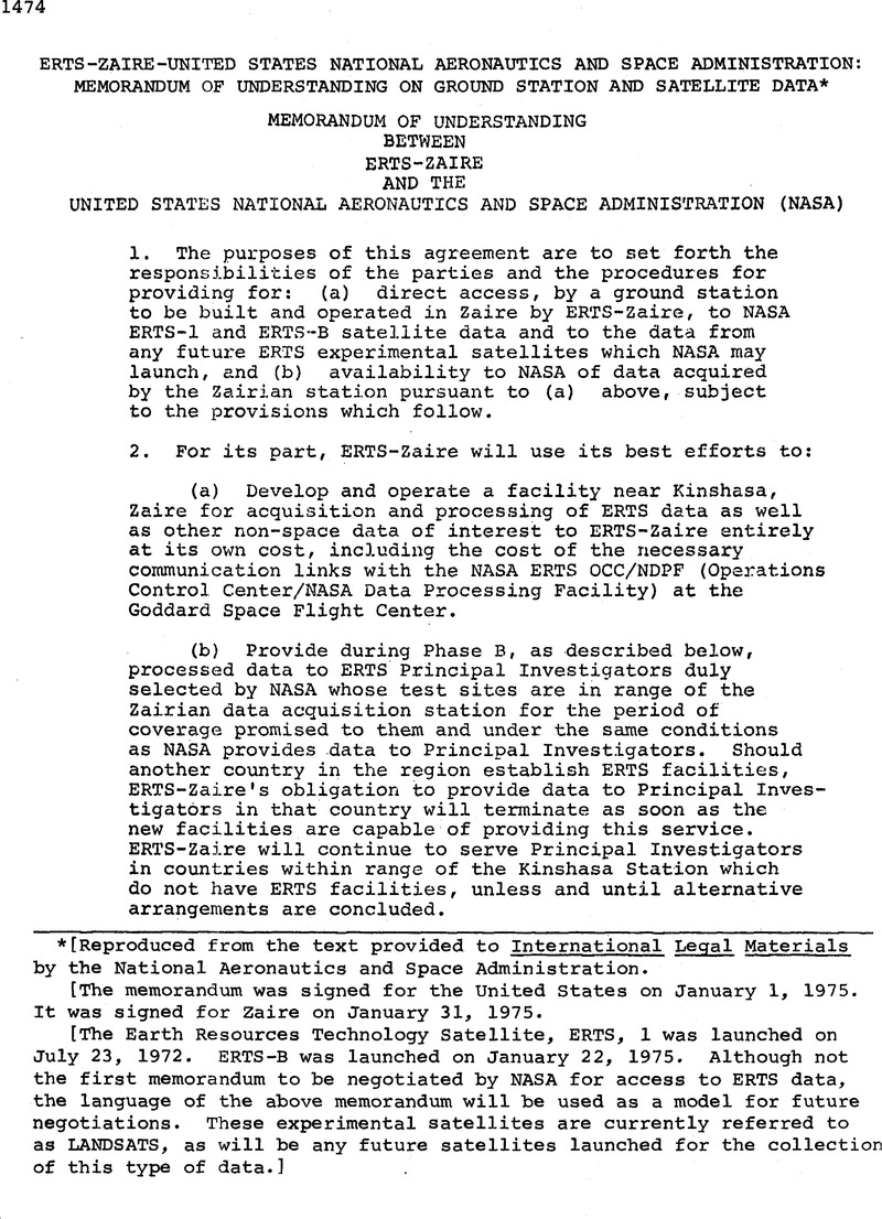
Erts-Zaire-United States National Aeronautics and Space Administration: Memorandum of Understanding on Ground Station and Satellite Data*
Published online by Cambridge University Press: 04 April 2017
Abstract
An abstract is not available for this content so a preview has been provided. Please use the Get access link above for information on how to access this content.
- Type
- Treaties and Agreement
- Information
- Copyright
- Copyright © American Society of International Law 1975
Footnotes
*
[Reproduced from the text provided to International Legal Materials by the National Aeronautics and Space Administration.
[The memorandum was signed for the United States on January 1, 1975. It was signed for Zaire on January 31, 1975.
[The Earth Resources Technology Satellite, ERTS, 1 was launched on July 23, 1972. ERTS-B was launched on January 22, 1975. Although not the first memorandum to be negotiated by NASA for access to ERTS data, the language of the above memorandum will be used as a model for future negotiations. These experimental satellites are currently referred to as LANDSATS, as will be any future satellites launched for the collection of this type of data.]
References
* [Reproduced from the text provided to International Legal Materials by the National Aeronautics and Space Administration.
[The memorandum was signed for the United States on January 1, 1975. It was signed for Zaire on January 31, 1975.
[The Earth Resources Technology Satellite, ERTS, 1 was launched on July 23, 1972. ERTS-B was launched on January 22, 1975. Although not the first memorandum to be negotiated by NASA for access to ERTS data, the language of the above memorandum will be used as a model for future negotiations. These experimental satellites are currently referred to as LANDSATS, as will be any future satellites launched for the collection of this type of data.]