


This note discusses some points of glaciological interest studied by the author while with the University of St. Andrews expedition to West Greenland in 1965.
Glacier Recession
It is possible to obtain an estimate of the time that has elapsed since a glacier started to retreat by measuring the size of certain crustaceous lichens growing on freshly exposed rock surfaces in the glacier foreland (Reference Beschel and RaaschBeschel, 1961). The longer the time that has elapsed since the recession, the larger and hence the older will be the lichens growing in the foreland. If the growth rate of the lichen under the climatic conditions of the foreland is known, the date at which the lichen started to grow on the rock surface can be estimated.
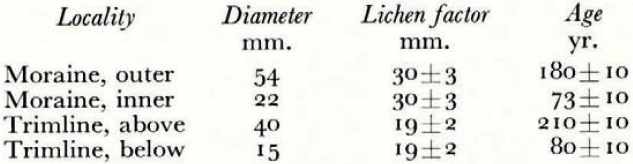
The present lichenometric work shows that the terminal moraines of a glacier can reflect the changes that take place in the accumulation region of the glacier. The two terminal moraines of a glacier, at lat. 65° 43′ N. and north of the Puiartoq inlet of Ikamiut kangerdluarssuat, were compared with the trimline of the highland ice field which fed the glacier. The moraines were of similar development and intensity, about 2 m. high, 70 m. apart and 1.35 km. from the present position of the glacier front. The maximum diameters of the lichen thalli of the collective species Rhizocarpon geographicurn were measured on the boulders of the moraines and on the rock surface at the trimline, 30 m. above the snow level of the ice field. The moraines were at 180 m. and the trimline at 850 m. above sea-level. The results arc given in Table I. The lichen factor is the maximum diameter of a century-old thallus of the species and it was estimated from the data on other West Greenland moraines, including the nearby moraines of Tasuissaq A and B glaciers at lat. 65° 34′ N. (Reference Beschel and RaaschBeschel, 1961).
The behaviour of the glacier agrees with that of other glaciers in West Greenland (Reference WeidickWeidick, 1959) The glacier shows two of the several possible advances of modern times: an advance to its maximum extension at the outer moraine around 1780 and a re-advance to the inner moraine around 1890. There was no evidence for moraines earlier than 1780 or later than 1890. The extent and rate of the retreat was similar to that of the Tasuissaq A and B glaciers. The most important point was that the lowering of the snow level on the ice field was accompanied by, if not followed after a time interval by, a retreat of the glacier front. The climatic fluctuations responsible for a variation in the accumulation-ablation balance of the ice field had indirectly led to the movement of the glacier front.
Quaternary Marine Deposits
Since the last ice age, fluctuations in sea-level have occurred on the west coast of Greenland (Reference LawsenLawsen, 1950). Marine shell beds, formed during a period when the sea-level was constant, were exposed above the present sea-level when a fluctuation occurred. There are five different Quaternary shell-bed sequences along the coast, but only the two youngest ones occur in the Sukkertoppen area.
Two shell-bed terraces occur at Niaqornarssuaq at the head of Ikamiut kangerdluarssuat (lat. 65° 47′ N., long. 52° 41′ W.). The lower, younger shell bed is at 8.5±0.3 m. above the high-tide mark, and the upper bed is at 17±0.3 m. Very worn and weathered shell specimens on the bed were collected and identified by A. Weidick and Mrs. E. Nordman, Grønlands Geologiske Undersøgelse. The lower bed contained the following species: Pecten islandicus, Mytilis edulis, Tellina calcarea, Saxicava arctica, Mya truncata, Balanus crenatus, Balanus balanus (all abundant); Astarte borealis?, Volutomitra groenlandica, Maroma calcarea, Littorina sp. (all uncommon); Astarte elliptica, Maroma loveni (single specimens). The upper bed contained Balanus crenatu.s, Balanus balanus (abundant); Pecten islandicus, Saxicava arctica, Mya truncate (uncommon). The age of the upper bed is 5,000–7,000 yr. and it was deposited under climatic conditions similar to those of the present day.
Ice-Dammed Lakes
There were two small lakes between a mountainside and the ice of the highland ice field at lat. 65° 46′ N., long. 52° 18′ W. The lakes were 200 m. apart on either side of a rock spur which deflected the flow of the glacier away from the mountainside, and their surfaces were 30–40 m. below the névé surface at 860 m. above sea-level. There had been a recent abrupt fall in the surface level of the upper lake by about 15 m., and this had stranded large névé blocks on the gravel scree slope of the mountainside and on the glacier ice, but there had been no corresponding change in the level of the lower lake. The upper lake was ice-free, while the lower lake was covered with close-packed floes. It is therefore concluded that the upper lake was draining into the glacier itself rather than into the lower lake. However, aerial photographs taken in 1948 (Geodaetisk Institut, Denmark, 507C-N, 26–29, 18 July 1948) showed a marked difference, with the ice of the upper lake unbroken and the lower lake ice-free except for minor floating floes. In this case it is inferred that the lower lake level was rising rather than falling and possibly re-floating old stranded névé blocks. The recent history of these two lakes therefore indicates that they can show independent and relatively rapid fluctuations in their levels due to changes in their internal drainage pattern into the glacier.

