
No CrossRef data available.
Article contents
Extract
In his valuable Contributions to the History of Southern Aeolis, Mr. Ramsay remarks (Journ. Hell. Stud. II. 2, p. 278): ‘In the plain of the Kodja we might expect more than one Aeolic settlement, if it be fully explored.’ This prediction was verified a few months only after it was written by discoveries made in this district in the spring of 1881, by Mr. George Dennis, M. Salomon Reinach, M. Baltazzi, and myself. I published a brief account of them in the Academy of April 9th, 1881, and M. Reinach has alluded to them, in the history of his excavations on the site of Myrina, in the Bulletin de Correspondence hellénique April 1882; but do details in regard to them have yet appeared. These details I now propose to give, throwing the account of them, for the sake of convenience, into narrative form.
Mr. Ramsay has already explained the topography of the coast from Myrina to Kymê. Midway between the two, about two and a half miles from Kyniê and three from Myrina, stands the little Greek village of Ali Aghá, while the Koja Chai, or ‘Big River,’ flows into the sea just below the ancient acropolis of Myrina, now known as Kalabassary. The Koja runs in an easterly direction, turning slightly to the north about eight miles from its mouth, towards the ruins of Namrût Kalessi, already described by both Mr. Ramsay and M. Reinach. Before entering the sea it is joined by a stream which runs past the village of Güzel Hissár.
- Type
- Research Article
- Information
- Copyright
- Copyright © The Society for the Promotion of Hellenic Studies 1882
References
page 220 note 1 M. Reinach, however, may be right in identifying the Cape Hydra of Strabo with Lija Bornû, in which case Adae will have stood on the promontory of Arab Chiflik, and the city to which the tombs of Guzel Hissár belonged must remain undetermined.
page 122 note 1 In the excellent map prefixed to the article of MM. Pottier and Reinach in the Bull. de Corr. hell. April 1882, the site is called Uzûn-Hassanly from the village near it.
page 225 note 1 Kymê is the Aeolic form of κώμν ‘village,’ and must consequently have originally been the name of the unwalled village which grew up on the sea-coast after the destruction of the older Kymê by the Aeolic invaders. What this was called we do not know.
page 226 note 1 I much doubt whether the inscription mentioned by Stark can be the one discovered by Mr. Dennis, as Stark implies that it was above the head of Niobê.
page 226 note 2 The ornament had this appearance:—
page 227 note 1 The inscription on the column is somewhat curious, as it runs thus:— 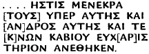 Kάβιος seems meant for Gavius rather than Caius. Menekratês and his son Mênophilos are mentioned in the inscription found in the church. Both names occur in Smyrnian inscriptions. (For Menekratês see C. I. G. 3251, 3252, 3379; for Mênophilos, 3141, 3142, 3190, 3279.)