


Introduction
The upper Maastrichtian to lower Danian Maastricht Formation of the Chalk Group consists of bioclastic calcarenites and calcirudites (Felder, Reference Felder, Zagwijn and van Staalduinen1975; Felder & Bosch, Reference Felder and Bosch2000; Jagt & Jagt-Yazykova, Reference Jagt, Jagt-Yazykova, Jagt, Donovan and Jagt-Yazykova2012) deposited in a proximal region of the Late Cretaceous Chalk Sea, in the Campine Basin, north of the Anglo-Brabant and Rhenish massifs (Fig. 1a). The Maastricht Formation has garnered scientific interest since the pioneering work of Dumont (Reference Dumont1849), who introduced the ‘système maestrichtien’ and established a type section on Mount Saint Peter, south of the Dutch city of Maastricht. Since then, the fossil content of the formation has been widely studied (Hofker, Reference Hofker1966; Felder & Bless, Reference Felder and Bless1989; Felder & Bosch, Reference Felder and Bosch2000; Felder, Reference Felder2001; Jagt, Reference Jagt2005; van der Ham et al., Reference van der Ham, van Konijnenburg-van Cittert and Indeherberge2007, Reference van der Ham, Jagt, Renkens and van Konijnenburg-van Cittert2010, Reference van der Ham, van Konijnenburg-van Cittert, Jagt, Indeherberge, Meuris, Deckers, Renkens and Laffineur2017; Keutgen, Reference Keutgen2018; Jagt et al., Reference Jagt, Deckers, Donovan, Fraaije, Goolaerts, van Der Ham, Hart, Jagt-Yazykova, Van Konijnenburg-van Cittert and Renkens2019).

Figure 1. (a) Cenomanian to Danian palaeogeographic map of the Late Cretaceous Chalk Sea of northwest Europe (modified from Vejbaek et al., Reference Vejbaek, Andersen, Dusar, Herngreen, Krabbe, Leszczyński, Lott, Mutterlose, Van der Molen, Doornenbal and Stevenson2010, after Ziegler, Reference Ziegler1982). Abbreviations: SNS: Southern North Sea; WNB: West Netherlands Basin; RVG: Roer Valley Graben. (b) The Upper Cretaceous of South Limburg is an extension of the subsurface stratigraphy of the Campine Basin of Belgium. The outcrops of South Limburg extend to the provinces of Liège and Limburg in Belgium and the German state of North Rhine–Westphalia, near Aix-la-Chapelle. (c) Simplified geological map of South Limburg with emphasis on the distribution of the Maastricht Formation. The Maastricht Formation has been traditionally subdivided into a Maastricht limestone in the west and a Kunrade limestone in the east.
The Maastricht Formation has been informally subdivided into six members: the Valkenburg, Gronsveld, Schiepersberg, Emael, Nekum and Meerssen members (Fig. 2a). Additionally, eight horizons have been identified, most of which have been described in the literature as a hardground or fossil hash level (Fig. 2a) (Felder, Reference Felder, Zagwijn and van Staalduinen1975; Felder & Bosch, Reference Felder and Bosch2000). A popular subdivision of the formation into two units, the Maastricht and the Kunrade ‘facies’, is often used alongside these members (Francken, Reference Francken1947; Hofker, Reference Hofker1966; Felder & Bosch, Reference Felder and Bosch2000). Here, we use ‘facies’ between inverted commas because this subdivision does not correspond to facies in the modern sense of the term (see Teichert, Reference Teichert1958). The two ‘facies’ are also referred to in the literature as the Maastricht and Kunrade chalks (e.g., Pollock, Reference Pollock1976), beds (e.g., Francken, Reference Francken1947), and limestones (e.g., Felder, Reference Felder, Zagwijn and van Staalduinen1975; Felder & Bosch, Reference Felder and Bosch2000; Simon, Reference Simon2003). For a historical overview of the stratigraphy of the Kunrade limestone, we refer the reader to Felder (Reference Felder1977). Here, we follow Felder (Reference Felder, Zagwijn and van Staalduinen1975) and Felder & Bosch (Reference Felder and Bosch2000) in using ‘limestone’ to refer to the two units. The main difference between the two limestones appears to be related to diagenesis: the Maastricht limestone consists of soft calcarenites, whereas the Kunrade limestone contains well-cemented calcarenites that alternate with soft calcarenites. The Maastricht limestone occurs in western South Limburg and the Kunrade in eastern South Limburg (Fig. 1c) (Felder et al., Reference Felder, Bosch and Bisschops1984). An interfingering of the two limestones is thought to occur near Valkenburg aan de Geul, in central South Limburg (Fig. 1) (Felder & Bosch, Reference Felder and Bosch2000).

Figure 2. (a) Stratigraphic diagram of the Maastricht Formation, based on Felder (Reference Felder, Zagwijn and van Staalduinen1975) and Felder & Bosch (Reference Felder and Bosch2000). The stratigraphic codes are relative to the River Meuse. (b) Simplified stratigraphic diagram. Here, we propose abandoning the subdivision of the Maastricht Formation into six members proposed by Felder (Reference Felder, Zagwijn and van Staalduinen1975) and to formalise the subdivision of the formation into lower and upper members, which was also proposed by Felder (Reference Felder, Zagwijn and van Staalduinen1975). The upper member of the Maastricht Formation is only present in the west. The contact between the Maastricht Formation and the underlying Gulpen Formation has been called the Lichtenberg horizon, which can be traced in boreholes and outcrops of the Maastricht Formation.
Identification of the six members and eight horizons of the Maastricht Formation is ambiguous, usually requiring a priori knowledge of the stratigraphy of South Limburg or a characterisation of the fossil content. Most stratigraphic studies thus far have relied on fossil content to subdivide and correlate the Maastricht Formation (e.g., Hofker, Reference Hofker1966; Felder, Reference Felder, Zagwijn and van Staalduinen1975, Reference Felder1977; Felder, Reference Felder2001; Felder et al., Reference Felder, Bless, Demyttenaere, Dusar, Meessen and Robaszynski1985). This is due to a lack of clear and distinguishing lithostratigraphic criteria. For this reason, members and horizons of the Maastricht Formation have not been formally incorporated in the Stratigraphic Nomenclature of the Netherlands. The lack of a lithostratigraphic framework based on modern facies studies hampers stratigraphic correlation between outcrops and, more importantly, boreholes. A facies characterisation and facies-based lithostratigraphic framework of the Maastricht Formation in South Limburg is particularly urgent because groundwater is abstracted from aquifers in the formation and geological models currently in place fail to predict facies heterogeneity and, consequently, aquifer properties.
The paucity of facies studies means that little is known about the relation between sedimentary processes and products and how this translates into the distribution of facies and the stratigraphic architecture of the formation. This is a missed opportunity because the Maastricht Formation is an uncommon record of the proximal zone of an epeiric ramp, an environment of deposition with no modern equivalents. Stratigraphic records of such proximal zones are uncommon because they are prone to erosion. Facies characterisation of the Maastricht Formation is expected to improve our understanding of the sedimentary processes and products of the proximal zone of epeiric ramps.
We studied eight outcrops of the Maastricht Formation across South Limburg (Fig. 1c) and carried out a (micro)facies analysis of the outcrops. Here, we show that the Maastricht Formation can be subdivided into three lithofacies and five microfacies. The lithofacies reflect the traditional subdivision of the formation into Maastricht and Kunrade limestones and can be organised in two depositional stages. Facies distribution was controlled by water temperature, nutrient levels and storminess.
Our results suggest that the current informal subdivision of the Maastricht Formation into six members and seven horizons is untenable. The formation is best subdivided into lower and upper members, a subdivision also proposed by Felder (Reference Felder, Zagwijn and van Staalduinen1975). The Kunrade limestone should be afforded the status of formation.
The Maastricht Formation
The Maastricht Formation is part of the Chalk Group and crops out in South Limburg, the Netherlands, in the German state of North Rhine–Westphalia, near Aix-la-Chapelle (Aachen), and in the Belgian provinces of Liège and Limburg (Fig. 1b) (Bless et al., Reference Bless, Felder, Meessen, Bless, Dusar and Streel1987; Robaszynski, Reference Robaszynski2006). The formation is late Maastrichtian to early Danian (Keutgen, Reference Keutgen2018; Vellekoop et al., Reference Vellekoop, Kaskes, Sinnesael, Huygh, Déhais, Jagt, Speijer and Claeys2022) and has been subdivided into nine foraminiferal zones (Hofker, Reference Hofker1966) and two dinoflagellate zones (Schiøler et al., Reference Schiøler, Brinkhuis, Roncaglia and Wilson1997). The formation dips gently (∼4°) towards the north-northwest and its thickness varies between 45 and 90 m (Felder & Bosch, Reference Felder and Bosch2000; Robaszynski et al., Reference Robaszynski, Dhondt, Jagt, Bultynck and Dejonghe2002). In the Netherlands, the formation is also present in the subsurface in the Roer Valley Graben (Bless et al., Reference Bless, Dusar, Felder and Swennen1993) and the Peel Block (Gras & Geluk, Reference Gras and Geluk1999). The formation is absent in other parts of the Netherlands, where its lateral equivalent is the upper part of the epeiric-pelagic Ommelanden Formation; the lateral transition between the two formations is poorly defined, however. In Belgium, the formation is also present in the subsurface in the Campine Basin (Slimani et al., Reference Slimani, Louwye, Dusar and Lagrou2011) and in the Anglo-Brabant Massif (Dusar & Lagrou, Reference Dusar and Lagrou2007a). The Maastricht Formation is a lateral equivalent of the Rowe Formation in the Southern North Sea, of the Tor Formation in the Central North Sea, and of the Reitbrook Formation in the North German Basin. The Rowe Formation is a white, flint-bearing chalk (British Geological Survey, 2020) and the Tor Formation consists of white or pale grey chalky limestones (Gradstein et al., Reference Gradstein, Waters, Charnock, Munsterman, Hollerbach, Brunstad, Hammer and Vergara2016). The Reitbrook Formation is essentially the same unit as the Maastricht Formation (Fahrion, Reference Fahrion1984).
The Maastricht Formation consists of epeiric-neritic deposits of a proximal zone of the Late Cretaceous Chalk Sea, on and immediately to the north of the Anglo-Brabant and the Rhenish massifs (Fig. 1a). The Chalk Sea covered most regions of northwest Europe from the Cenomanian until the Danian. In South Limburg, Chalk Sea deposits are generally younger than elsewhere in the North Sea area and dated as Santonian to middle Danian (Felder, Reference Felder, Zagwijn and van Staalduinen1975; Jagt, Reference Jagt1999; Felder & Bosch, Reference Felder and Bosch2000). Sedimentation in the Chalk Sea took place under the influence of compressional tectonics related to seafloor spreading in the Bay of Biscay and the onset of the Alpine orogeny (Ziegler, Reference Ziegler, Illing and Hobson1981; Vejbaek et al., Reference Vejbaek, Andersen, Dusar, Herngreen, Krabbe, Leszczyński, Lott, Mutterlose, Van der Molen, Doornenbal and Stevenson2010). Compression caused the inversion of many Cimmerian basins (Vejbaek et al., Reference Vejbaek, Andersen, Dusar, Herngreen, Krabbe, Leszczyński, Lott, Mutterlose, Van der Molen, Doornenbal and Stevenson2010), including the Roer Valley Graben, north of South Limburg. In the Campanian and perhaps even in the early Maastrichtian, the inverted, subaerially exposed ‘graben’ acted as a sediment source and as a barrier for faunal migration (Bless et al., Reference Bless, Felder, Meessen, Bless, Dusar and Streel1987; Gras & Geluk, Reference Gras and Geluk1999). In the late Maastrichtian, as relative sea level rose, the inverted basin became an area of sediment accumulation again (Bless et al., Reference Bless, Felder, Meessen, Bless, Dusar and Streel1987, Reference Bless, Dusar, Felder and Swennen1993).
In South Limburg, the Maastricht Formation crops out mainly in abandoned quarries, used to extract flint and limestone or produce cement, in a SW–NE region between Maastricht and Heerlen (Fig. 1c). The outcrops were studied in the second half of the 20th century, when most quarries were still active, and the rocks were classified using the lithostratigraphic subdivision of Felder (Reference Felder, Zagwijn and van Staalduinen1975). Nowadays, quarrying in the region has ceased, except in the Kunrade and Sibber quarries, and the remaining outcrops are weathered and partially covered by vegetation.
Although the Maastricht Formation is part of the Chalk Group, the formation is mostly a calcarenitic unit, unlike the typical North Sea chalk in that it is much coarser and contains, at times, a significant terrigenous component. In lithological terms, the outcrops of the Maastricht Formation can be categorised according to an east-west and a lower-upper subdivisions (Fig. 3). The east-west subdivision corresponds to the Maastricht and Kunrade limestones (Fig. 2a) (Francken, Reference Francken1947; Felder, Reference Felder, Zagwijn and van Staalduinen1975; Felder & Bless, Reference Felder and Bless1989; Felder & Bosch, Reference Felder and Bosch2000; Jagt & Jagt-Yazykova, Reference Jagt, Jagt-Yazykova, Jagt, Donovan and Jagt-Yazykova2012). Outcrops west of the city of Valkenburg aan de Geul (see Fig. 1c) are mostly poorly cemented bioclastic calcarenites (Maastricht limestone) (Fig. 4), whereas outcrops east of the city are lithologically similar but with more terrigenous material and an alternation between well- and poorly cemented layers (Kunrade limestone) (Fig. 5). The lower-upper subdivision is defined based on grain size and the occurrence of flint: The lower Maastricht Formation is characterised by coarse silt to very fine sand bioclastic calcarenites with common flint, which occurs in layers or scattered (Fig. 4) (Felder & Bosch, Reference Felder and Bosch2000). The upper Maastricht Formation is characterised by coarse to very coarse sand bioclastic calcarenites with common pebble-size bioclasts occurring scattered or in shell beds (coquinas) (Fig. 6) (Felder & Bosch, Reference Felder and Bosch2000). Flint is scarce or absent in the upper Maastricht Formation (Fig. 6a). The lower Maastricht Formation encompasses the Maastricht and Kunrade limestones and has been informally subdivided into the Valkenburg, Gronsveld, Schiepersberg and Emael members (Fig. 2a). The upper Maastricht Formation encompasses only the Maastricht limestone, as it crops out only in the west, having been eroded in the east (Dusar & Lagrou, Reference Dusar and Lagrou2007b). It has been informally subdivided into the Nekum and Meerssen members (Fig. 2a).

Figure 3. Stratigraphic logs, (micro)facies distribution and sample positions of the studied outcrops. MSL: mean sea level. Bioclastic calcarenite (F1) is the most common facies in the Maastricht Formation; it occurs in most outcrops with the exception of the Kunrade quarry, where bioclastic calcarenites with subordinate terrigenous grains (F2) occur. Bioclastic calcirudites (F3) are found mainly in the upper Maastricht Formation, though they can also be found in the Kunrade quarry (lower Maastricht Formation). See Fig. 1c. for the location of the outcrops.

Figure 4. Outcrop photographs of the Maastricht limestone (F1), lower Maastricht Formation. (a) Massive bioclastic calcarenites (Trichterberg) (person on the right for scale). (b) Bioclastic calcarenites with low-angle cross bedding (Däölkesberg). (c) Solution pipes filled with Neogene mud with flint (Trichterberg) (person on the lower right for scale). (d) Nodular flint (Trichterberg). (e) Paramoudra flint (Trichterberg). (f) Tabular flint (Trichterberg). (g) Nodular flint with core filled by bioclastic calcarenite (Trichterberg). Nodular, tabular and paramoudra flints are all three likely related to burrowing and are common in the lower Maastricht Formation.

Figure 5. Outcrop photographs of the Kunrade limestone, lower Maastricht Formation (Kunrade quarry). (a) Alternation between poorly and well-cemented layers of bioclastic calcarenites (F2). (b) Poorly cemented bioclastic calcirudite with flint, a belemnite (be) fragment and mudclasts (F3). (c) (d) Close-up of the well-cemented (wc) and poorly cemented (pc) layers. At the top, a calcirudite bed (F3) can be seen. (e) Thalassinoides burrow enclosed in flint at the base of a highly cemented layer. (f) Bioclastic calcirudite (F3) with a coal pebble reworked from the underlying Palaeozoic.

Figure 6. Outcrop photographs of the upper Maastricht Formation. (a) Massive bioclastic calcarenites (F1) without flint (Duivelsgrot). The absence of flint is typical of the upper Maastricht Formation. (b) Erosional surface (dashed line) at the base of a coquina lag (bioclastic calcirudite with a bioclastic calcarenite matrix, F3) that fines abruptly upwards to a bioclastic calcarenite (F1) (Oude Grot). (c) Association of poorly cemented bioclastic calcarenites (F1) and calcirudites (F3). The calcirudite beds (between solid lines) exhibit tabular and lenticular geometries often with an erosional base (dashed line) (Oude Grot). (d) Scleractinian coral (sc) and bryozoan (br) in a bioclastic calcarenite with echinoderms, bryozoans, bivalves and benthic foraminifera (former Blom quarry).
The subdivision of the Maastricht Formation into six members is based on the morphology and quantity of flint and on the quantification of fossil content (ecozones) (Felder, Reference Felder, Zagwijn and van Staalduinen1975; Felder et al., Reference Felder, Bless, Demyttenaere, Dusar, Meessen and Robaszynski1985; Felder & Bosch, Reference Felder and Bosch2000; Jagt & Jagt-Yazykova, Reference Jagt, Jagt-Yazykova, Jagt, Donovan and Jagt-Yazykova2012). The members are so similar in terms of lithology and aspect in the field that it is challenging to recognise them. Seven horizons are used as the limits of the members (Fig. 2a). These horizons are hardgrounds and/or nonsequences (diastems). As is the case for the members, discerning the horizons is challenging. The horizons can be recognised in some parts of the former ENCI quarry, where most occur (Felder, Reference Felder, Zagwijn and van Staalduinen1975; Felder & Bosch, Reference Felder and Bosch2000) but, even in the quarry, they are not always continuous and tracing them is often not possible, as pointed out by Felder & Bosch (Reference Felder and Bosch1998). The absence of distinctive marker beds and horizons, along with lithological similarities, can on occasion make it difficult to distinguish the Maastricht Formation from the underlying Gulpen and overlying Houthem formations (Mottequin et al., Reference Mottequin, Ghysel, Laloux, Marion, Pingot, Jagt and Jagt-Yazykova2012; Mottequin & Marion, Reference Mottequin and Marion2013).
Material and methods
We studied eight outcrops of the Maastricht Formation during three field visits to South Limburg in July and September 2022 and in May 2023 (Fig. 1c). We used the biostratigraphic framework of Hofker (Reference Hofker1966) and the (informal) lithostratigraphic framework of Felder (Reference Felder, Zagwijn and van Staalduinen1975) and Felder & Bosch (Reference Felder and Bosch2000) to select outcrops representative of the Upper Cretaceous to Danian geology of South Limburg.
During the three visits, we described, measured and sampled the outcrops. We collected 38 samples: 14 blocks using a hammer and 24 palaeomagnetic standard cores, 1′ (2.54 cm) in diameter, using a drill bit mounted on a pistol grip cordless drill (Table 1). We described primary and secondary structures, as well as rock fabric, texture, composition and colour. Most rocks in South Limburg are friable and poorly lithified as well as fine-grained (coarse silt to very fine sand). For this reason, in the field, the rocks were classified according to the grain size scheme of Grabau (Reference Grabau1904), which subdivides limestones into calcilutites, calcarenites and calcirudites. Application of the classification schemes of Folk (Reference Folk1959) and Dunham (Reference Dunham and Ham1962) is hindered by the fine texture of the rocks. The taphonomic attributes of coquinas, such as fragmentation, abrasion, rounding and orientation of shells, were described following the method proposed by Kidwell et al. (Reference Kidwell, Fürsich and Aigner1986) and Kidwell (Reference Kidwell, Allison and Briggs1991). We define a coquina as a bioclastic concentration with skeletal grains coarser than 2 mm, that is, a bioclastic calcirudite, regardless of the type of skeletal grain. Previous authors have used the terms shell hash or fossil hash for such layers (e.g., Felder & Bosch, Reference Felder and Bosch2000; Jagt & Jagt-Yazykova, Reference Jagt, Jagt-Yazykova, Jagt, Donovan and Jagt-Yazykova2012; Vellekoop et al., Reference Vellekoop, Van Tilborgh, Van Knippenberg, Jagt, Stassen, Goolaerts and Speijer2019; O’Hora et al., Reference O’Hora, Petersen, Vellekoop, Jones and Scholz2021). The morphology of flint was described based on the work of Mortimore (Reference Mortimore2014) and Aliyu (Reference Aliyu2016), who subdivided flint into nodular, tabular (coalesced flint nodules in a continuous layer parallel to bedding), sheet (formed along fractures and faults), tubular (20–30 mm thick tubes with a core that may be either empty or filled) and paramoudra (hollow barrel-shaped or ring-like flints that can be a metre or more in diameter and several metres long). We have not observed any sheet morphologies in the field. We estimated the bioturbation intensity of rocks in outcrop and hand specimen using the bioturbation index of Droser & Bottjer (Reference Droser and Bottjer1986), which ranges from 1 (no bioturbation) to 6 (bedding totally homogenised).
Table 1. List of samples with geographic and stratigraphic details, sampling technique, analytical work carried out, porosity and summary of mineral composition. See Fig. 1c for a map of the sampling locations and Fig. 2b for a schematic stratigraphic column. Abbreviations: l. Maastricht: lower Maastricht Formation; u. Maastricht: upper Maastricht Formation; TS: thin section; MF: microfacies; Por.: porosity; qXRD: quantitative X-ray diffraction; XRD Gp.: mineral composition group (see Fig. 10); Qz: quartz; Cal: calcite

Thirty-four samples, representative of the diversity of facies in the field, were selected to produce 30 µm thick thin sections (Table 1). Thin sections were produced by National Petrographic in Texas. Half of each thin section was stained with a solution of Alizarin Red-S and ferricyanide to distinguish calcite from dolomite and ferroan from nonferroan carbonates (Dickson, Reference Dickson1966). The micrographs shown in this paper were taken from the unstained half of the thin sections. The thin sections were also impregnated with a blue epoxy to highlight porosity. The thin sections were described using a Zeiss Axio microscope, and scans were made using a Zeiss Axioscan.
The rocks were grouped into microfacies and classified according to the scheme of Dunham (Reference Dunham and Ham1962). Most rocks of the Maastricht Formation exhibit grain-supported fabrics with high porosity, little cement and no or scarce fine-grained calcite. In the classification of Dunham (Reference Dunham and Ham1962), grain-supported silt- and sandstones are subdivided into pack- and grainstones based on their depositional texture. Packstones have carbonate mud between the grains, whereas grainstones are virtually mud-free (<1%). This subdivision of grain-supported silt- and sandstones requires the identification of synsedimentary carbonate mud, which is not always easy to distinguish from penecontemporaneous carbonate mud. Penecontemporaneous carbonate mud is introduced into the sediment shortly after deposition by a variety of processes, such as infiltration of mud and mixing due to bioturbation (e.g., Wright, Reference Wright1992; Alsuwaidi et al., Reference Alsuwaidi, Morad, Mansurbeg and Sulieman2020). Diagenetic micrite, a product of cementation, adds to the difficulty in distinguishing fine-grained calcite that represents sedimentation in quiet water environments (but see Schieber et al., Reference Schieber, Southard, Kissling, Rossman and Ginsburg2013) from fine-grained calcite introduced by other processes after deposition. Moreover, some fine-grained calcite may represent (partly) disintegrated composite grains, such as peloids (e.g., Farrow & Fyfe, Reference Farrow and Fyfe1988).
Some grain-supported silt- and sandstones of the Maastricht Formation contain some fine-grained calcite, usually <10%. At the same time, they show solution-enlarged interparticle porosity which opens the possibility that some of the ‘matrix’ may have been washed away from the fabric. This means that the present texture of the rocks would not correspond to their depositional texture, which may have been more clearly that of a packstone. High bioturbation indices mean that this ‘matrix’ may also have been introduced into the fabric of an original grainstone (Wright, Reference Wright1992). For this reason, we consider here grainstones as grain-supported silt- and sandstones with <15% ‘matrix’ between the grains. This parallels the practical approach to the distinction between arenites and wackes in siliciclastic rocks, where a threshold of 15%, is also used (Dott, Reference Dott1964).
The abundance of components in the rocks was described using the terminology proposed by Macquaker & Adams (Reference Macquaker and Adams2003). In their scheme, a rock containing more than 90% of a particular component is described as ‘dominated’ by that component; a rock that contains 50 to 90% of a particular component is described as ‘rich’ in that component; and a rock that contains 10 to 50% of a particular component is described as ‘bearing’ that component. Constituent percentages in the thin sections were estimated using the visual comparison charts of Baccelle & Bosellini (Reference Baccelle and Bosellini1965). Porosity was estimated three times per sample using colour thresholds in ImageJ by Fiji software, with an average error of ±2%. Pore type classification was based on Choquette & Pray (Reference Choquette and Pray1970).
The mineral content of 36 samples was determined by X-ray powder diffraction (XRD) (Table 1). Sample selection ensured that all facies and microfacies were analysed. Twenty-nine of these samples were selected for quantitative XRD analysis (qXRD). Quantification of calcite, quartz and other components in the samples was carried out by adding a known amount of corundum to each sample and calculating the integrated intensities of the peaks of interest (Hubbard & Snyder, Reference Hubbard and Snyder1988) (Table 1). The samples were McCrone milled in 6 mL of ethanol for 12 minutes using zirconium oxide grinding elements. The resulting slurry was air-dried overnight. The samples were spiked with corundum and homogenised by dry McCrone milling for 1 minute. We backloaded each spiked sample into a sample holder with a cavity diameter of 25 mm. The samples were run at the Department of Earth Sciences of Utrecht University on a Bruker D8 Advance with a LYNXEYE detector and a θ/θ goniometer. We used Cu-Kα radiation (λ = 1.54056 Å) and operated the tube at 40 kV and 40 mA. We used a 2.5° primary Soller slit, a fixed divergence slit (0.165 mm) and a motorised anti-scatter screen. Samples were measured from 3 to 70 °2θ, in 0.02° steps, and counted for 2 s per step. For quantification, we used an in-house reference library of standard patterns of pure minerals. All standard patterns were run under the same diffractometer conditions as the unknown samples.
Results
Lithofacies
F1 – Bioclastic calcarenite
F1 is a yellow to beige, poorly cemented bioclastic calcarenite (Fig. 4a). This facies is usually massive, but low-angle cross bedding can be observed on occasion, such as on Däölkesberg Hill (Fig. 4b). The size of skeletal grains in this facies ranges from coarse silt to fine sand. Most grains are broken and difficult to identify due to their small size. Fine sand skeletal grains of bryozoans, echinoderms and molluscs (mainly bivalves) can be recognised, however. Coarse silt and very fine sand grains of glauconite and quartz constitute <3% of the rock. This facies can either contain no flint or be flint-bearing. Flint size ranges from a few centimetres to tens of centimetres in diameter, and flint occurs in four types: nodular (Fig. 4d), vertical tubes (Fig. 4e), tabular (Fig. 4f) or horizontal tubes (Fig. 4g). Flint can occur in layers or scattered throughout the outcrops. The rocks are either not bioturbated or contain isolated burrows (BI: 1 to 3). Karstification features, such as solution pipes (Fig. 4c) filled with Neogene mud with flints, occur in this facies. In outcrops, such features only occur in the facies F1, although they may also occur in other facies in the subsurface. Facies F1 occurs only in the Maastricht limestone and is exposed in the walls of the former ENCI quarry and at Trichterberg, Blankenberg and Däölkesberg.
F2 – Bioclastic calcarenite with subordinate terrigenous grains
F2 is a yellow to beige, well-bedded bioclastic calcarenite (Fig. 5a) with <10% terrigenous grains, such as coarse silt to very fine sand quartz and granule- and pebble-size Palaeozoic coal lithoclasts (Fig. 5f). This facies differs from F1 in its higher terrigenous content, as well as in the presence of glauconite and of a smectitic clay matrix. In the field, F2 is accompanied by a striking pattern of cementation that resulted in an alternation of poorly and more well-cemented horizons (Fig. 5c, d). Beds are centimetres thick, with tabular or lenticular geometries. As is the case for F1, skeletal grains are coarse silt to fine sand in size, broken and hard to identify. Fragments of belemnites and bivalves can be observed (Fig. 5b). Glauconite constitutes <5% of the rock. The rocks are either not bioturbated or contain isolated burrows (BI: 1 to 3). Flint is mostly tubular (Fig. 5e), often enclosing Thalassinoides and Ophiomorpha burrows. F2 is exposed in the walls of the Kunrade quarry and is usually described as the Kunrade limestone of the Maastricht Formation.
F3 – Bioclastic calcirudite (coquina)
F3 consists of bioclastic rudstones (coquinas) in centimetre to a few metre-thick beds (Fig. 6b, c). This facies occurs in association with F1 (Fig. 6a–c). Skeletal grains are mostly bryozoans, echinoderms, molluscs, belemnites, serpulids and benthic foraminifera. Occasionally, scleractinian corals (Fig. 6d) and sponges occur. Most skeletal grains are disarticulated and dissociated. They are poorly sorted, densely or loosely packed and oblique or parallel to bedding. The size of the skeletal grains ranges from fine sand to pebbles. In some beds, cross bedding can be observed, and the skeletal grains exhibit normal grading (Fig. 6b). The beds have a wedge, lenticular or tabular geometry, and sometimes the lower bedding surface has erosional relief (Fig. 6b). This facies is usually not bioturbated (BI: 1). F3 is common in the upper Maastricht Formation, in the Maastricht limestone (former ENCI quarry, Duivelsgrot, former Blom quarry and Oude Grot). However, it also occurs in the Kunrade limestone in three beds at the top of the Kunrade quarry (Fig. 5c, d).
Microfacies
MF1 – Very fine sand bioclastic packstone
MF1 is a very fine sand bioclastic packstone (Fig. 7a–d). We emphasise that ‘sand’ is here used in a textural sense for any grain, including carbonate grains. Carbonate grains make ∼50% of the rock and are dominated by coarse silt to very fine sand-broken skeletal grains (∼90%), which makes their identification challenging. Some fine sand skeletal grains of benthic foraminifera (Fig. 7c), molluscs (Fig. 7a), bryozoans and echinoderms (Fig. 7d) also occur, making ∼10% of the framework. This microfacies is carbonate mud bearing, which constitutes >40% of the rock. Carbonate mud occurs between the grains (Fig. 7a), in layers, or as burrow fill (Fig. 7b). The microfacies is sometimes characterised by irregular horizontal lamination, which is often disturbed by isolated burrows (BI: 3). Glauconite constitutes <5% of the rocks; it occurs as peloids and as the infill of cavities of skeletal grains (Fig. 7d). Glauconitic peloids have a diameter of ∼160 µm. Porosity in this microfacies ranges from 4 to 10%; most are solution-enlarged interparticle (∼95%) and some are intraparticle (∼5%). Solution seams are common in this microfacies (Fig. 7a). Skeletal grains fractured due to compaction can also be observed. Cement constitutes ∼5% of this microfacies and only occurs as syntaxial echinoderm overgrowths and dog-tooth calcite. This microfacies occurs in lithofacies F1 in the lower Maastricht Formation in the former ENCI quarry and in the Blankenberg outcrop, immediately above the Lichtenberg horizon. This microfacies also occurs in lithofacies F2 in one sample in the lower part of the Kunrade quarry.

Figure 7. Micrographs of the Maastricht limestone, lower Maastricht Formation (MF1 and MF2). All in plane polarised light. (a) Very fine sand bioclastic packstone with micritized bivalves (bv) (red arrow), benthic foraminifera (fm) and solution seams (yellow arrow) (MF1) (Sample: BL2). (b) Burrow (above dashed line) filled with carbonate mud and coarse silt bioclasts (MF1) (Sample: BL2). (c) Benthic foraminifera (fm) and coarse silt bioclasts in a carbonate mud matrix (MF1) (Sample: BL2). (d) Bioclast of an echinoderm with glauconite filling intraparticle porosity (MF1). (e) Fine sand bioclastic grainstone bearing in echinoderms (ec) with syntaxial calcite overgrowth (red arrows) (MF2) (Sample: EC9). (f) Bioclastic grainstone with coarse sand benthic foraminifera (fm), bivalves (bv) and echinoderms (ec) and compactional features (red arrows), such as fractured bioclasts and tangential contacts between grains (MF2) (Sample: EC8). (g) Isolated patches of carbonate mud between the grains after dissolution of carbonate content (grains and carbonate mud), which resulted in an enlargement of the interparticle porosity (red arrow) (MF2) (Sample: EC6). (h) Echinoderm bioclasts (ec) with syntaxial calcite overgrowth (red arrow) and bivalve (bv) with dog-tooth calcite (yellow arrow) in a bioclastic grainstone (MF2) (Sample: EC6).
MF2 – Fine sand bioclastic grainstone
MF2 is a fine sand bioclastic grainstone (Fig. 7e–h), with >60% carbonate grains. Bioclasts of echinoderms constitute ∼30% of the carbonate grains and include echinoderm plates, spines and crinoid columnals (Fig. 7e). Echinoderm grains are always broken, and their size ranges from very fine sand to very coarse sand. Benthic foraminifera constitutes ∼15% of the skeletal grains (Fig. 7f, g); the grains are unbroken and fine sand in size. The remaining fraction of the carbonate grains comprises broken grains of molluscs, bryozoans, peloids, red algae and whole calcispheres. Quartz and glauconite are very rare or absent (<3%). Carbonate mud constitutes less than 10% of the rock and occurs between grains or mud clasts. Carbonate mud between grains occurs as isolated patches, which can be due to mud infiltration, bioturbation or dissolution, resulting in an enlargement of interparticle porosity (Fig. 7g). Mud clasts range from very fine sand to granule in size. This microfacies is weakly cemented (<10%). Common cement types are syntaxial echinoderm overgrowths and dog-tooth and isopachous-bladed calcite (Fig. 7h). Compactional features, such as fractured skeletal grains and grains exhibiting tangential contacts, can be observed (Fig. 7f). Porosity in this microfacies ranges from 15 to 35% and is mainly solution-enlarged interparticle. MF2 occurs associated only with lithofacies F1, in the lower Maastricht Formation in the former ENCI quarry, on Däölkesberg Hill and at Trichterberg.
MF3 – Very fine sand bioclastic grainstone with subordinate quartz grains
MF3 is a very fine sand bioclastic grainstone with subordinate quartz grains (Fig. 8). This microfacies is calcisphere bearing (∼15% of the rock) and contains subordinate glauconite (Fig. 8d) and quartz grains (Fig. 8a, f), which constitute ∼5% of the rock. Calcispheres have a diameter between 50 and 100 µm (Fig. 8). Some incertae sedis grains, which look like bundles of calcispheres with a diameter of ∼50 µm, are also common (Fig. 8g–h). These grains do not have a clear origin; however, they resemble calcareous green algae and, in some cases, the stems of charophytes (Fig. 8h). In addition to calcispheres, skeletal grains in this microfacies include echinoderms (Fig. 8a), bryozoans (Fig. 8i), red algae, bivalves (Fig. 8f) and benthic foraminifera (Fig. 8b, e). Very fine sand peloids (<10%) also occur. The grains have been broken into very fine to medium sand bioclasts, only some of which are rounded.

Figure 8. Micrographs of the Kunrade limestone, lower Maastricht Formation (MF3). All in plane polarised light except where indicated. (a) (b) Weakly cemented (<5% calcite cement) very fine sand bioclastic grainstone with calcispheres (cs), quartz (qz), benthic foraminifera (fm) and incertae sedis (is) grain that resembles calcareous green algae (Sample: (a) KS38; (b) KS6). (c) Strongly cemented (>20% calcite cement) bioclastic grainstone with calcisphere (cs) (Sample: KS22). (d) Benthic foraminifera (fm) with intraparticle porosity filled with glauconite (Sample: KS29). (e) Detail of micrograph (d) showing an isopachous-bladed calcite rim (red arrow) around a benthic foraminifera (fm) (Sample: KS29). (f) Mould of a bivalve (bv) in a very cemented sample, with quartz (qz) and echinoderms (ec). PPL: plane polarised light; XPL: cross polarised light (Sample: KS29). (g) (h) Incertae sedis grains similar to calcareous green algae which, together with calcispheres, are common (∼15%) in MF3 (Sample: KS31). (i) Incertae sedis grain that resembles a colonial invertebrate, such as a bryozoan (Sample: KS10).
This microfacies occurs in two types based on their degree of cementation: weakly (Fig. 8a, b) and strongly cemented (Fig. 8c–f). In weakly cemented samples, calcite cement constitutes <5% of the rock and comprises isopachous and dog-tooth calcite and syntaxial echinoderm overgrowths. Porosity in these rocks ranges from 5 to 30%, depending on the carbonate mud content. In strongly cemented samples, calcite cement is ∼20% of the rock, and the cement is dominated by drusy (Fig. 8c) and bladed (Fig. 8e) calcite (Fig. 8d–f). In most strongly cemented samples, the recognition of skeletal grains is challenging due to dissolution (Fig. 8f) and intense recrystallization. Porosity in strongly cemented rocks is<5%. All samples of this microfacies are from the Kunrade limestone (lithofacies F2) in the Kunrade quarry.
MF4 – Fine sand red algae-bearing bioclastic grainstone
MF4 is a fine sand red algae-bearing bioclastic grainstone. Carbonate grains constitute>60% of the rock and are dominated by skeletal grains, which are often rounded and abraded (Fig. 9a–c). The size of skeletal grains ranges from fine to medium sand. Compared to the other microfacies, MF4 is richer in broken fragments of red algae, which comprise ∼15% of the rock (Fig. 9a). Bioclasts of echinoderms, serpulids, bivalves, bryozoans and scleractinian corals can be recognised, as well as whole benthic foraminifera and calcispheres. Some very fine sand to fine sand peloids (Fig. 9a), which constitute <3% of the carbonate grains, also occur. Bioturbation is assumed to be high (BI: 5 to 6) due to the lack of sedimentary structures. Carbonate mud constitutes <10% of the rock. Quartz and glauconite are rare (<3%) or absent. Cement constitutes <3% of the rock and consists of syntaxial echinoderm overgrowths and dog-tooth and isopachous-bladed calcite (Fig. 9b). Porosity ranges from 15 to 30% and is mostly solution-enlarged interparticle. This microfacies occurs in lithofacies F1 in the upper Maastricht Formation in the former ENCI quarry and in the Duivelsgrot.

Figure 9. Micrographs of the upper Maastricht Formation (MF4 and MF5). All in plane polarised light. (a) (b) Fine sand red algae-bearing bioclastic grainstone with broken and rounded skeletal grains (red arrow), benthic foraminifera (fm), red algae (ra), ooid with a concentric structure and a dissolved nucleus (oo), and peloids (pl) (MF4) (Sample: DU1). (c) Benthic foraminifera with a rim of isopachous fibrous calcite (red arrow) (Sample: DU1). (d) Coarse sand bioclastic packstone with echinoderms (ec), crinoids (cr), bryozoans (br), bivalves (bv), foraminifera (fm) and red algae (ra) (MF5) (Sample: DU2). (e) Dog-tooth calcite (red arrow) partially filling intraparticle porosity of a bryozoan (MF5) (Sample: DU2).
MF5 – Coarse sand bioclastic packstone
MF5 is a coarse sand bioclastic packstone (Fig. 9d, e). Carbonate grains are dominated by broken skeletal grains, but unlike the other microfacies, in MF5, their size ranges up to coarse and very coarse sand. The skeletal grain component is echinoderm (echinoderm plates, spines and crinoid columnals), bryozoan, red alga, bivalve and benthic foraminifera bearing (Fig. 9d). Scleractinian corals and sponges occur occasionally (<3%). Skeletal grains of red algae and bivalves are usually abraded, while skeletal grains of echinoderms, bryozoans and benthic foraminifera are unabraded. This microfacies is carbonate mud bearing (∼30% of the rock). Carbonate mud occurs between the grains or as a burrow fill. Bioturbation occurs mostly as isolated burrows (BI: 3 to 4). Quartz and glauconite are absent. This microfacies may be weakly or strongly cemented. In weakly cemented samples, calcite cement constitutes <5% of the rock and comprises syntaxial overgrowth of echinoderms and dog-tooth calcite (Fig. 9e). In these rocks, porosity is ∼20% and mostly solution-enlarged interparticle. In strongly cemented samples, calcite cement constitutes ∼20% of the rock and comprises drusy calcite. Porosity in strongly cemented samples is <1% and mostly moldic and shelter porosity. This microfacies occurs associated only with lithofacies F3. It occurs in the Kunrade limestone, at the Kunrade quarry and in the upper Maastricht Formation in the Duivelsgrot.
Mineralogical analysis
Based on qXRD analysis, the samples can be subdivided into three groups (Fig. 10). The main difference between them is calcite content. Group I (Fig. 10a) comprises three samples and is characterised by a lower content in calcite ranging from ∼65 to 80% (average: µ = 74%). Quartz content is relatively high, ranging from ∼5 to 15% (µ = 8%). Other components may include albite, chamosite, flint (opal CT), glauconite, gypsum and smectite and constitute ∼15 to 20% (µ = 18%) of the rock. Two samples in this group are from the Kunrade quarry and one from the former ENCI quarry (Table 1).

Figure 10. X-ray diffractograms representative of the three compositional groups of the Maastricht Formation (see Table 1 for details). (a) Group I is characterised by calcite contents ranging from ∼65 to 80%, quartz ranging from ∼5 to 15%, and other components from ∼15 to 20%. (b) Group II is characterised by calcite contents ranging from ∼80 to 90%, quartz from ∼0 to 5% and other components from ∼10 to 20%. (c) Group III is characterised by calcite contents ranging from ∼90 to 100%, quartz ranging from ∼0 to 2% and other components from ∼0 to 10%. Abbreviations: Sme: smectite; Glt: glauconite; Opl: opal CT (flint); Qz: quartz; Cal: calcite; Chm: chamosite; Ab: albite. Intensity is plotted on a logarithmic scale. Sample KS12 was collected in the Kunrade quarry and samples EC3 (lower Maastricht Formation) and EC14 (upper Maastricht Formation) were collected in the former ENCI quarry.
Group II (Fig. 10b) comprises fifteen samples and is characterised by an intermediate content in calcite ranging from ∼80 to 90% (µ = 85%). Quartz content in this group ranges from ∼0 to 5% (µ = 1%). Other components constitute ∼10 to 20% (µ = 13%) of the rock. In this group, most of these other components are flint (opal CT), glauconite and/or smectite. The samples in this group are predominantly lower and upper Maastricht limestone (former ENCI quarry, Duivelsgrot, Trichterberg, Blankenberg and Däölkesberg); two samples are Kunrade limestone (Kunrade quarry) (Table 1).
Group III (Fig. 10c) comprises eleven samples and is characterised by high contents in calcite ranging from ∼90 to 100% (µ = 93%). Quartz content in this group ranges from ∼0 to 2% (µ = 1%). Other components can include flint (opal CT), glauconite and smectite and constitute ∼0 to 10% (µ = 6%) of the rock. The samples in this group are predominantly Kunrade limestone (Kunrade quarry); one sample is lower Maastricht limestone (Trichterberg) and another upper Maastricht limestone (former Blom quarry). Using the porosity measured in the thin sections as a proxy for calcite cement, we can subdivide this group into two subgroups. Samples in group III are either MF2 or MF3, in which carbonate mud is practically absent. Group IIIa is characterised by rocks with high porosity, ranging from ∼20 to 40%. In this subgroup, calcite content is related to carbonate grains. Rocks of group IIIb (Table 1) are pervasively cemented and are characterised by lower porosity, ranging from ∼0 to 5%. In this subgroup, some of the quantified calcite is a cement.
The Maastricht limestone (usually group II) has a high yet intermediate calcite content, a generally low quartz content and a relatively high content of other components. There is no clear difference between the lower and the upper Maastricht limestones. Other components are mostly authigenic and not necessarily related to terrigenous input. The Kunrade limestone shows the greatest compositional variability: it contains the samples with the highest quartz content (group I) but also those with the highest calcite content (group III). The calcite content of the Kunrade limestone is on average higher than the Maastricht limestone. The higher calcite content is not only due to cementation but also due to lower dilution of calcite by other components. Indeed, samples of group IIIa, which are poorly cemented, are the most calcite rich of the Maastricht Formation.
Discussion
Stratigraphic issues in the Maastricht Formation
The Maastricht Formation is currently informally subdivided into two hierarchical levels (Felder, Reference Felder, Zagwijn and van Staalduinen1975; Felder & Bosch, Reference Felder and Bosch2000): one which subdivides the formation into a lower and an upper Maastricht Formation and another which subdivides the formation into six members, delimited by seven horizons (Fig. 2a). The horizons have been described as hardgrounds and/or nonsequences (diastems) (Felder & Bosch, Reference Felder and Bosch2000). The lower Maastricht Formation encompasses the lower four of the six members (Valkenburg, Gronsveld, Schiepersberg and Emael members) and the upper Maastricht Formation encompasses the upper two (Nekum and Meerssen members). Parallel to this informal lithostratigraphic subdivision, the Maastricht Formation has also been subdivided into two ‘limestones’, the Maastricht limestone in the west and the Kunrade limestone in the east (Fig. 1c), largely based on their aspect in the field. In the Netherlands, none of these members or horizons have been formally accepted. In Belgium, however, the subdivision of the Maastricht Formation into six members was formally accepted, even though ‘the distinction of the members defined in the type area is generally not feasible’ (National Commission for Stratigraphy Belgium, n.d.-b). Additionally, in Belgium, the Kunrade limestone has been raised to the status of formation, the Kunrade Formation (contra Felder, Reference Felder1977).
The lithostratigraphic subdivision of the Maastricht Formation is heavily based on the study of the ENCI quarry (Felder, Reference Felder, Zagwijn and van Staalduinen1975, Reference Felder1976; Zijlstra, Reference Zijlstra1995; Felder & Bosch, Reference Felder and Bosch1998, Reference Felder and Bosch2000; Jagt & Jagt-Yazykova, Reference Jagt, Jagt-Yazykova, Jagt, Donovan and Jagt-Yazykova2012), which has resulted in a number of stratigraphic issues that were recognised early on by the authors who proposed the subdivision. Already in 1975, Felder (Reference Felder, Zagwijn and van Staalduinen1975) assigned different codes to the members of the Maastricht Formation east and west of the River Meuse (Fig. 2a). Essentially, west of the River Meuse, the lower Maastricht Formation cannot be subdivided into four members but was grouped by Felder (Reference Felder, Zagwijn and van Staalduinen1975) under one code (VIIIw) that corresponds to a single ‘lower member’. Felder (Reference Felder, Zagwijn and van Staalduinen1975) did recognise, however, the lower four members of the Maastricht Formation in the ENCI quarry, which is located immediately west of the River Meuse, and we assume the difficulty in recognizing the four lower members of the Maastricht Formation must arise farther south and west, in Belgium. Even inside the ENCI quarry, correlation of the lower four members of the Maastricht Formation is not without problems: according to Felder & Bosch (Reference Felder and Bosch1998), the Gronsveld and Schiepersberg members cannot be recognised as independent lithostratigraphic units in the southern part of the quarry and farther south towards Belgium, while in the northern part of the quarry, they can. Difficulties in extending the lithostratigraphy away from the ENCI quarry are not confined to the direction of Belgium but arise in the direction of Heerlen too (Fig. 1c): the schematic cross-sections presented by Felder (Reference Felder, Zagwijn and van Staalduinen1975) and Felder & Bosch (Reference Felder and Bosch2000) suggest the authors could recognise the six members of the Maastricht Formation only in the Maastricht limestone in the west of South Limburg. According to Felder et al., (Reference Felder, Bless, Demyttenaere, Dusar, Meessen and Robaszynski1985, p. 12), because of ‘rapid lateral changes in […] lithology, [the lithostratigraphic subdivision proposed by his brother Felder (Reference Felder, Zagwijn and van Staalduinen1975)] can only be used within the area described by the author’.
The challenges in the recognition of the members of the Maastricht Formation have already been pointed out by other authors (Bless et al., Reference Bless, Felder, Meessen, Bless, Dusar and Streel1987; Dusar & Lagrou, Reference Dusar and Lagrou2007b; Slimani et al., Reference Slimani, Louwye, Dusar and Lagrou2011; Jagt & Jagt-Yazykova, Reference Jagt, Jagt-Yazykova, Jagt, Donovan and Jagt-Yazykova2012). Bless et al., (Reference Bless, Felder, Meessen, Bless, Dusar and Streel1987) suggested that recognition of the members in the lower Maastricht Formation is more challenging than in the upper Maastricht Formation. In the lower Maastricht Formation, lithological aspects of the members are poorly defined and the marker horizons that limit them cannot be recognised by field characteristics (Bless et al., Reference Bless, Felder, Meessen, Bless, Dusar and Streel1987). These problems arise from the similar lithological characteristics of each member, which represent a single calcarenitic facies (F1) comprising two rather similar microfacies (MF1 and MF2). All four members have been described as yellow to white, very fine- to fine-grained limestone, with the occurrence, shape and size of flints constituting the key difference (Felder, Reference Felder, Zagwijn and van Staalduinen1975; Felder & Bosch, Reference Felder and Bosch2000; Robaszynski et al., Reference Robaszynski, Dhondt, Jagt, Bultynck and Dejonghe2002; Jagt & Jagt-Yazykova, Reference Jagt, Jagt-Yazykova, Jagt, Donovan and Jagt-Yazykova2012). Using flint to recognise members can be problematic, as the generation of flint is not directly related to the surrounding lithology, and flint is not always present in outcrops and boreholes of the Maastricht Formation.
The two members of the upper Maastricht Formation are similar to the lower Maastricht Formation (F1) but are coarser grained (MF4) and characterised by an absence of flint and by the common presence of coquina layers, which often have lenticular morphologies (F3) (Felder, Reference Felder, Zagwijn and van Staalduinen1975; Felder & Bosch, Reference Felder and Bosch2000; Robaszynski et al., Reference Robaszynski, Dhondt, Jagt, Bultynck and Dejonghe2002; Jagt & Jagt-Yazykova, Reference Jagt, Jagt-Yazykova, Jagt, Donovan and Jagt-Yazykova2012). The two members can sometimes be distinguished from each other by the more common presence of coquina layers in the Meerssen member; however, the limit between the two units – a Lepidorbitoides-rich coquina overlying a hardground referred to as the Caster Horizon – is often difficult to trace (Bless et al., Reference Bless, Felder, Meessen, Bless, Dusar and Streel1987). In the former Blom quarry (Fig. 1b), for example, where this horizon has been described (W.M. Felder & Bosch, Reference Felder and Bosch2000), it is difficult to distinguish the horizon from other coquinas of the Meersen member.
Although the lower and upper Maastricht Formation can be distinguished from each other by their lithological properties, recognizing the horizon, established by Felder (Reference Felder, Zagwijn and van Staalduinen1975), that limits them is difficult. The Laumont Horizon was used by Felder (Reference Felder, Zagwijn and van Staalduinen1975) and Felder & Bosch (Reference Felder and Bosch2000) as the limit between the Emael and Nekum members, and consequently between lower and upper Maastricht Formation (Fig. 2a). The Laumont Horizon, as is the case with other horizons in the Maastricht Formation, has been described as an irregularly developed hardground with one or more fossil beds on top (Felder & Bosch, Reference Felder and Bosch2000). Recognising this horizon is challenging given the occurrence of similar features throughout the Maastricht Formation. The transition between the lower and upper Maastricht Formation can be seen only in the west, with the upper Maastricht Formation being eroded in the east (Dusar & Lagrou, Reference Dusar and Lagrou2007b). Instead of a sharp contact between the lower and upper Maastricht Formation, attributed to the Laumont Horizon (see Felder & Bosch, Reference Felder and Bosch2000), we observed a gradual increase in the grain size, the disappearance of flint layers and a decrease in the occurrence of scattered flint. Because of this gradual change, we assume that the limit between the lower and upper Maastricht Formation occurs in a transitional interval instead of a single horizon.
In eastern South Limburg, near Heerlen (Fig. 1c), the Maastricht Formation is essentially unrecognisable and none of the members described in the western exposures can be identified; the uppermost Maastrichtian is rather represented by the Kunrade limestone (F2 and MF3), which has been mapped as a separate unit from the Maastricht limestone (Fig. 1c) (see Felder et al., Reference Felder, Bosch and Bisschops1984). Francken (Reference Francken1947, p. 132) first described the Kunrade limestone as an alternation of ‘strongly cemented, hard and compact limestone beds and softer beds of yellow marly limestone’. Francken (Reference Francken1947) and W.M. Felder (Reference Felder, Zagwijn and van Staalduinen1975) considered the Kunrade and the Maastricht limestones as the same formation due to the similarity in texture (very fine to fine sand) and colour (yellowish white); they subdivided the Maastricht Formation into two limestones or ‘facies’ due to (i) the characteristic cementation pattern of the Kunrade limestone, absent in the Maastricht limestone; (ii) the presence of terrigenous grains, and Palaeozoic lithoclasts in particular, in the Kunrade limestone; and (iii) the fossil content. The cemented horizons of the Kunrade limestone are discontinuous and cannot be followed over great distances, which means they cannot be used for correlation (Francken, Reference Francken1947; Pollock, Reference Pollock1976). It has been suggested, however, that the cemented horizons can be correlated with the hardground horizons in the Maastricht limestone of western South Limburg (Felder, Reference Felder1978). This correlation has not been confirmed, and east-west correlation of the two ‘facies’ remains inconclusive. Hofker (Reference Hofker1966) correlated the Kunrade limestone to the upper Maastricht Formation, while Felder & Bless (Reference Felder and Bless1989), based on the quantification of fossil content in the Kunrade area, correlated the Kunrade limestone with the upper Gulpen Formation (Lanaye member) and the lower Maastricht Formation, up to the base of the Emael member. Here, we follow the correlation of Felder & Bless (Reference Felder and Bless1989) to the lower Maastricht Formation but place the Kunrade limestone above the Lichtenberg horizon (Fig. 2b).
The east-west transition between the Kunrade and Maastricht limestones occurs in central South Limburg. The correlation between these limestones is still a subject of debate, however. The schematic cross-sections presented by several authors (Felder, Reference Felder, Zagwijn and van Staalduinen1975, Reference Felder1977, Reference Felder1978; Felder et al., Reference Felder, Bless, Demyttenaere, Dusar, Meessen and Robaszynski1985; Felder & Bosch, Reference Felder and Bosch2000) suggest an interfingering of the Kunrade and Maastricht limestones near Valkenburg aan de Geul in the Schaelsberg section, where the Däölkesberg outcrop is located (Fig. 1c). The same hypothesis was proposed by Pollock (Reference Pollock1976). The Schaelsberg section is a ∼60 m thick composite section that comprises five outcrops between the bank of the River Geul and the top of Däölkesberg Hill. The outcrops at the base of the composite section have been attributed to the Kunrade limestone (W.M. Felder & Bosch, Reference Felder and Bosch2000). The limestones, however, are not similar to those found in any of the outcrops of the Maastricht Formation. They are hybrid arenites rich in quartz and glauconite. (We note here that we have not included this facies in the present study, as we assign it to the Gulpen Formation.) Däölkesberg outcrop, at the top of the composite section, has been described as another ‘limestone’, the Schaelsberg limestone, similar to both the Kunrade and the Maastricht limestones (Felder, Reference Felder1978; Felder & Bosch, Reference Felder and Bosch2000). However, though bedded (Fig. 4b), the Däölkesberg outcrop does not contain well-cemented layers, a feature typical of the Kunrade limestone.
All the members of the Maastricht Formation had their stratotypes defined in quarries that were used for the extraction of natural stone or to produce cement in the second half of the 20th century (see Felder, Reference Felder, Zagwijn and van Staalduinen1975). At that time, the quarries were active, with fresh rock exposures available for study. Nowadays, the quarries are inactive, weathered, covered by vegetation and dangerous due to the risk of falling blocks. The quarries continue to be named as the stratotype for the members of the Maastricht Formation (Felder & Bosch, Reference Felder and Bosch2000; National Commission for Stratigraphy Belgium, n.d.-b), but the difficulty in accessing the exposures hampers the identification of the features that were used to define the members and their boundaries, such as hardgrounds. It is also not possible to compare the cores of new boreholes with the exposures described by Felder (Reference Felder, Zagwijn and van Staalduinen1975), making it hard to apply the informal lithostratigraphic scheme currently used.
Facies and stratigraphy of the Maastricht Formation
The Maastricht Formation in South Limburg comprises three lithofacies: two bioclastic calcarenites (F1 and F2) and a bioclastic calcirudite (F3). These facies can be organised into a lower and upper Maastricht Formation in the west (F1 and F3) (Maastricht limestone) and a Kunrade limestone in the east of South Limburg (F2).
Bioclastic calcarenites (F1) occur in the Maastricht limestone in the west of South Limburg and are associated with three microfacies: very fine sand bioclastic packstone (MF1), fine sand bioclastic grainstone (MF2) and fine sand red algae-bearing bioclastic grainstone (MF4). Microfacies MF1 and MF2 are restricted to the lower Maastricht Formation, while MF4 is restricted to the upper. Very fine sand bioclastic packstone (MF1) occurs predominantly at the base of the Maastricht Formation in the former ENCI quarry and at Blankenberg, close to the lower limit of the formation, the Lichtenberg horizon. This horizon is characterised by an up to 20 cm thick interval of glauconite-rich bioclastic calcarenites. It can be traced in the former ENCI quarry, and it can also be recognised in boreholes throughout South Limburg, often being used as a marker bed for correlation (Felder et al., Reference Felder, Bless, Demyttenaere, Dusar, Meessen and Robaszynski1985; Felder & Bosch, Reference Felder and Bosch2000; Jagt & Jagt-Yazykova, Reference Jagt, Jagt-Yazykova, Jagt, Donovan and Jagt-Yazykova2012; Vellekoop et al., Reference Vellekoop, Kaskes, Sinnesael, Huygh, Déhais, Jagt, Speijer and Claeys2022). This horizon has been interpreted as a lag deposit representing a stratigraphic hiatus (Robaszynski et al., Reference Robaszynski, Bless, Felder, Foucher, Legoux, Manivit, Meessen and Van der Tuuk1985; Vandenberghe et al., Reference Vandenberghe, Van Simaeys, Steurbaut, Jagt and Felder2004; Vellekoop et al., Reference Vellekoop, Kaskes, Sinnesael, Huygh, Déhais, Jagt, Speijer and Claeys2022) and subsequent drowning (Schiøler et al., Reference Schiøler, Brinkhuis, Roncaglia and Wilson1997). In the former ENCI quarry, MF1 gradually changes upwards to MF2 with a gradual decrease in carbonate mud content and an increase in grain size.
The lower Maastricht Formation in the east is represented by the Kunrade limestone, which comprises bioclastic calcarenites with subordinate terrigenous grains (F2) and, on occasion, bioclastic calcirudites (F3). The Kunrade limestone can be recognised by an alternation of poorly and more well-cemented horizons. Under the microscope, the Kunrade limestone is a very fine sand bioclastic grainstone (MF3). MF3 is calcisphere bearing and contains quartz grains.
In the upper Maastricht Formation, bioclastic calcarenites (F1) and bioclastic calcirudites (F3) occur associated. Compared to the lower Maastricht Formation, in the upper member, bioclastic calcarenites have no or rare flint. Bioclastic calcirudites (F3) are more common towards the top of the formation and occur in beds with a wedge-like, lenticular or tabular geometry. In the upper Maastricht Formation, F1 is associated with fine sand red algae-bearing bioclastic grainstone (MF4) with rounded and abraded grains, which does not occur in the lower Maastricht Formation (MF1 and MF2). Coarse sand bioclastic packstones (MF5) occur associated with bioclastic calcirudites (F3).
We propose abandoning the subdivision of the Maastricht Formation into six members, proposed by W.M. Felder (Reference Felder, Zagwijn and van Staalduinen1975), and to use the subdivision of the formation into a lower and an upper member, which was also proposed by W.M. Felder (Reference Felder, Zagwijn and van Staalduinen1975). The Kunrade limestone forms a distinct and mappable unit in the east of South Limburg. For this reason, it makes sense to follow the Belgian lithostratigraphic convention of affording the Kunrade limestone the status of formation (Dusar & Lagrou, Reference Dusar and Lagrou2007b; van der Ham et al., Reference van der Ham, van Konijnenburg-van Cittert, Jagt, Indeherberge, Meuris, Deckers, Renkens and Laffineur2017; National Commission for Stratigraphy Belgium, n.d.-a).
The subdivision between Maastricht and Kunrade limestones (formations) also represents two hydrostratigraphic units with distinct hydrogeological properties (Krings & Langguth, Reference Krings, Langguth, Bless, Bouckaert, Langguth and Streel1987). The Maastricht limestone is homogenous and has a high porosity under the microscope (Figs. 7, 9). The Kunrade limestone is more heterogeneous, with a lower porosity in well-cemented horizons and a higher porosity in poorly cemented horizons (Fig. 8). These well-cemented layers may function as a baffle to vertical water flow, reducing the connectivity between the more porous (poorly cemented) layers. Karstification features, such as solution pipes, may play an important role in increasing porosity and vertical permeability in the aquifer. In the Maastricht Formation, these features were described to preferentially occur in highly porous rocks (see Willems & Rodet, Reference Willems, Rodet and Demoulin2018). The vertical extent of these features in the subsurface, however, and how they affect aquifer properties is unclear (van Rooijen, Reference van Rooijen, Downing, Price and Jones1993). Further studies addressing porosity and permeability with plug measurements and a diagenetic characterisation of the rocks in the Maastricht and Kunrade limestones are necessary to elucidate possible shifts in aquifer properties.
Sedimentation of the Maastricht Formation
The limestones of the Maastricht Formation can be classified as a heterozoan association (sensu James, Reference James, James and Clarke1997). Heterozoan carbonates are characterised by an association of heterotrophic organisms and red algae. In the Maastricht Formation, this heterozoan association consists of echinoderms, bryozoans, molluscs, benthic foraminifera, serpulids and red algae. In the modern icehouse world, heterozoan carbonates typically occur in cool water settings (<20°C) in mid- to high-latitude regions (James, Reference James, James and Clarke1997; James & Jones, Reference James and Jones2015). These regions are typically nutrient-rich, with meso- to eutrophic conditions, under which heterotrophic organisms may dominate over phototrophic organisms (James, Reference James, James and Clarke1997; Halfar et al., Reference Halfar, Godinez-Orta, Mutti, Valdez-Holguin and Borges2006; Westphal et al., Reference Westphal, Halfar and Freiwald2010).
During the Late Cretaceous greenhouse climate, carbonate platforms were largely dominated by rudist reefs under photozoan-like conditions, and heterozoan carbonates were found only where terrigenous input or high-nutrient conditions inhibited the establishment of photozoan organisms (James, Reference James, James and Clarke1997; Kiessling et al., Reference Kiessling, Flügel and Golonka2003; Michel et al., Reference Michel, Borgomano and Reijmer2018). Unlike at present, however, it seems likely that high-nutrient seas were not restricted to cool water, and heterozoan carbonates may also have thrived in warmer settings (Westphal et al., Reference Westphal, Halfar and Freiwald2010).
During the Late Cretaceous, South Limburg was located at a palaeolatitude of ∼40° (van Hinsbergen et al., Reference van Hinsbergen, De Groot, Van Schaik, Spakman, Bijl, Sluijs, Langereis and Brinkhuis2015) in the wide northern mid-latitude warm humid belt (Chumakov et al., Reference Chumakov, Zharkov, Herman, Doludenko, Kalandadze, Lebedev, Ponomarenko and Rautian1995; Hay, Reference Hay2008). Clumped isotope analysis of the Maastricht Formation suggests water temperatures ranging from 12 to 25°C, indicating a warm temperate to subtropical sea (O’Hora et al., Reference O’Hora, Petersen, Vellekoop, Jones and Scholz2021). Environmental variables were not constant throughout the deposition of the Maastricht Formation, however (Bless, Reference Bless, Jagt and Janssen1988; O’Hora et al., Reference O’Hora, Petersen, Vellekoop, Jones and Scholz2021), and shifts in relative sea level, trophic conditions and water temperature were probably the main controls on facies change.
The Maastricht Formation was deposited in a shallow and proximal zone of the Late Cretaceous epeiric Chalk Sea. Two models are frequently used to explain facies distribution of carbonate rocks in epeiric settings: the epeiric ramp (Lukasik et al., Reference Lukasik, James, McGowran and Bone2000) and the epeiric platform models (Irwin, Reference Irwin1965). Both models are based on similar basin settings and share sedimentological characteristics. Epeiric ramps and epeiric platforms are characterised by extremely low to negligible slopes, a water depth of less than ten to tens of metres and a width of hundreds to thousands of kilometres (Shaw, Reference Shaw1964; Irwin, Reference Irwin1965; Lukasik et al., Reference Lukasik, James, McGowran and Bone2000). Under these conditions, fair weather waves and tides would have been damped by friction with the shallow seafloor and periodic storms were the dominant hydrodynamic process (Shaw, Reference Shaw1964; Irwin, Reference Irwin1965; Lukasik et al., Reference Lukasik, James, McGowran and Bone2000). In both models, facies belts were vast but facies distribution had different controls: in the epeiric ramp model, facies distribution was controlled by trophic gradients (Lukasik et al., Reference Lukasik, James, McGowran and Bone2000), whereas in the epeiric platform model, it was controlled by the energy of the environment (Irwin, Reference Irwin1965). Below, we discuss how aspects of both models are applicable to the Maastricht Formation, whose sedimentation was controlled by nutrient levels but also by storminess.
As previously discussed, based on (micro)facies analysis, the Maastricht Formation can be organised into a lower and an upper Maastricht Formation in the west (Maastricht limestone) and a Kunrade limestone in the east of South Limburg. This subdivision reflects different depositional conditions of the Maastricht Formation, which can, in turn, be organised into two depositional stages. Stage 1 encompasses the lower Maastricht limestone and the Kunrade limestone, which are lateral equivalents (see P.J. Felder & Bless, Reference Felder and Bless1989), and stage 2, the upper Maastricht limestone.
Stage 1 – Lower Maastricht Formation
During the first stage of deposition of the Maastricht Formation, the epeiric sea of South Limburg was more proximal in the east, where the Kunrade limestone (F2) was deposited. The Kunrade limestone is characterised by an alternation of poorly and more well-cemented layers of very fine sand bioclastic grainstone with subordinate quartz grains (MF3). Compared to the rocks of the Maastricht limestone in the west, the Kunrade limestone is richer in terrigenous content (Fig. 8a), yields a less diverse fauna (Jagt & Jagt-Yazykova, Reference Jagt, Jagt-Yazykova, Jagt, Donovan and Jagt-Yazykova2012) and contains pebbles of the underlying Palaeozoic (Fig. 5f) as well as plant debris (Jagt & Jagt-Yazykova, Reference Jagt, Jagt-Yazykova, Jagt, Donovan and Jagt-Yazykova2012). These characteristics suggest the proximity of fluvial input, potentially creating a nutrient-rich region (meso- to eutrophic) in a low-energy environment with a fully marine setting.
A distinctive feature of the Kunrade limestone is the common presence of calcispheres and incertae sedis grains (Fig. 8). Calcispheres are often considered to be dinoflagellates or green algal cysts and, less frequently, radiolarians and calcified acritarchs (Berkyová & Munnecke, Reference Berkyová and Munnecke2010; Flügel, Reference Flügel2010). The lack of diagnostic morphological features hampers the identification of these grains. Some of the incertae sedis grains have a structure that resembles some forms of calcareous algae, including the stem of charophytes (Fig. 8h). Although the identification of calcispheres and incertae sedis grains is not conclusive, their occurrence is a distinctive feature when compared with the Maastricht limestone. The common presence of these bioclasts, together with features that point to a more proximal setting, suggests that these organisms would be either sourced from freshwater settings or thrive in a nutrient-rich marine environment.
In the eastern, proximal setting, meso-to-eutrophic conditions were in place. These, as well as a higher terrigenous content, were probably due to higher fluvial input. In the western, more distal settings, mesotrophic conditions with low terrigenous input were in place, which resulted in the relatively pure limestones of the lower Maastricht limestone. These limestones occur as very fine sand bioclastic packstone (MF1) and fine sand bioclastic grainstone (MF2). As is the case for the Kunrade limestone in the east, the presence of very fine sand angular bioclasts of echinoderms, bryozoans and molluscs in the lower Maastricht limestone suggests deposition in a calm environment with minimal wave energy and uncommon storm events. In a more agitated environment, skeletal grains might break more often but abrasion and rounding of the clasts will take place at a faster pace, particularly as the grain size decreases. Other than by storms, bioclasts could be reworked only by wind-driven currents, since tidal currents were probably dampened in epeiric settings (see Mitchell et al., Reference Mitchell, Allison, Gorman, Piggott and Pain2011). A high bioturbation rate resulted in homogenous, massive-looking sediments without clear sedimentary structures. The intense bioturbation created conditions favourable for the development of flint (Zijlstra, Reference Zijlstra1995), which commonly replaces burrows. Although more distal, the Maastricht limestone still contains some plant remains, as described by van der Ham et al. (Reference van der Ham, Jagt, Renkens and van Konijnenburg-van Cittert2010), rare terrestrial palynomorphs (Schiøler et al., Reference Schiøler, Brinkhuis, Roncaglia and Wilson1997) and dinosaur fossils (Jagt et al., Reference Jagt, Mulder, Schulp, Dortangs and Fraaije2003).
At the time of deposition of the two limestones, meadows of seagrass were common (van der Ham et al., Reference van der Ham, van Konijnenburg-van Cittert and Indeherberge2007, Reference van der Ham, van Konijnenburg-van Cittert, Jagt, Indeherberge, Meuris, Deckers, Renkens and Laffineur2017; Jagt et al., Reference Jagt, Deckers, Donovan, Fraaije, Goolaerts, van Der Ham, Hart, Jagt-Yazykova, Van Konijnenburg-van Cittert and Renkens2019). At present, seagrass is typically associated with heterozoan carbonates in the inner shelf of shallow, warm-temperate seas, with temperatures ranging from 15 to 20°C (James & Jones, Reference James and Jones2015), such as in the western Mediterranean Sea and the Spencer Gulf in South Australia. In modern mesotrophic conditions, seagrass often occurs with red algae and large benthic foraminifera, two types of carbonate grain found in the Maastricht Formation (Michel et al., Reference Michel, Borgomano and Reijmer2018). This assemblage of carbonate grains suggests warm-temperate seas and mesotrophic conditions in South Limburg during deposition of the lower Maastricht Formation.
Stage 2 – Upper Maastricht Formation
In western South Limburg, the transition from lower to upper Maastricht Formation is marked by a gradual increase in grain size, a disappearance of flint layers and a decrease in the occurrence of scattered flint. An increase in the number of grains of red algae and large benthic foraminifera accompanies the increase in grain size, as does the common occurrence of fine sand red algae-bearing bioclastic grainstones (MF4). Bioclastic calcirudite (F3) beds, rich in coarse sand bryozoans, serpulids, red algae, echinoderms, molluscs and large benthic foraminifera (MF5), become more frequent upwards. In these beds, some scleractinian corals can also be observed (Fig. 6d) and shark teeth have also been described (see Francken, Reference Francken1947).
The increasing presence of red algae, with subordinate corals, suggests a change in environmental conditions. Due to the presence of scleractinian corals and large numbers of red algae, the upper Maastricht Formation may be characterised as a heterozoan-photozoan transition (sensu Halfar et al., Reference Halfar, Godinez-Orta, Mutti, Valdez-Holguín and Borges2004). Deposition of these carbonates would have taken place under mesotrophic conditions and in a warmer setting than the lower Maastricht Formation. Temperature is estimated to have increased from ∼16°C in the lower Maastricht Formation to ∼25°C in the upper Maastricht Formation (O’Hora et al., Reference O’Hora, Petersen, Vellekoop, Jones and Scholz2021). O’Hora et al. (Reference O’Hora, Petersen, Vellekoop, Jones and Scholz2021) suggested that warmer conditions were a response to the Late Maastrichtian Warming Event, which is coeval with the onset of Deccan volcanism. The fossil assemblage also points to a warming trend with the establishment of a tropical (Francken, Reference Francken1947) to subtropical sea (Liebau, Reference Liebau1978; Jagt & Jagt-Yazykova, Reference Jagt and Jagt-Yazykova2016) surrounded by temperate settings.
In the upper Maastricht Formation, bioclastic calcirudites (F3) are particularly common. The coquina beds (F3) consist of disarticulated and dissociated skeletal grains with poor sorting and are delimited by an erosional surface at the base (Fig. 6b). In these beds, red algae have been preserved as coarse sand to granule-size grains, which are often coarser than the red algae preserved in the finer facies (F1, MF4) that occur associated to F3. The good preservation of skeletal grains, namely no significant bioerosion and abrasion of the grains; the convex-upwards orientation of shells parallel to bedding (Fig. 6b); and the basal erosional surfaces suggest that the beds are a product of short-duration currents, such as storm flows (see Fürsich & Oschmann, Reference Fürsich and Oschmann1993). The abundance of coquinas in the upper Maastricht (Meersen member) relative to the lower Maastricht Formation and the Nekum member has been interpreted as reflecting a shallowing trend whereby storm waves could more easily erode the seafloor (W.M. Felder & Bosch, Reference Felder and Bosch2000). Schiøler et al. (Reference Schiøler, Brinkhuis, Roncaglia and Wilson1997), based on marine palynomorph assemblages, also interpreted a shallower setting for the upper Maastricht Formation. In the proximal zone of epeiric seas, however, where the Maastricht Formation was deposited, it is likely that the shallow seafloor was always above storm wave base; drops in sea level were not necessarily required to enable seafloor erosion. For this reason, we propose that the increase in calciruditic facies reflects an increase in storminess during the deposition of the uppermost Maastricht Formation.
Conclusions
We show that the Maastricht Formation can be subdivided into three lithofacies and five microfacies. These facies are predominantly bioclastic calcarenites with varying amounts of terrigenous grains and authigenic materials, such as flint. Our results suggest that the Maastricht Formation is best subdivided into lower and upper members instead of the six members described in the literature. In outcrop, the lower member consists of bioclastic calcarenites (F1); under the microscope, this facies can be subdivided into very fine sand bioclastic packstones (MF1) and fine sand bioclastic grainstones (MF2). In outcrop, the upper member consists of bioclastic calcarenites (F1) and calcirudites (F3); under the microscope, bioclastic calcarenites (F1) of the upper member are fine sand red algae-bearing bioclastic grainstones (MF4), and calcirudites (F3) are coarse sand bioclastic packstones (MF5). Our facies and lithostratigraphic scheme reflect the traditional subdivision of the Maastricht Formation into Maastricht and Kunrade limestones. The Kunrade limestone is a distinct and mappable unit in the east of South Limburg, and it should be afforded the status of formation. The Kunrade limestone consists of bioclastic calcarenites with subordinate terrigenous grains (F2), which under the microscope are a very fine sand bioclastic grainstone with subordinate quartz grains (MF3) that occurs in two types based on the degree of cementation: a weakly and a strongly cemented.
The Maastricht Formation represents sedimentation in a proximal zone of the Late Cretaceous Chalk Sea; it was deposited in an epeiric ramp in which facies distribution was controlled by water temperature, trophic conditions and storminess. Sedimentation of the Maastricht Formation can be subdivided into two depositional stages. Stage 1 encompasses the lower part of the formation and is characterised by heterozoan carbonates deposited under cooler, mesotrophic conditions in a nutrient-rich, more proximal region of the epeiric sea. Stage 2 is characterised by heterozoan-photozoan carbonates deposited in a warmer and stormier environment with slightly lower nutrient levels.
Acknowledgements
We thank Gaby Bollen and Natuurmonumenten for granting us access to the former ENCI quarry; Bas and Marc Vervuurt for allowing us to study and sample a fresh wall in the Kunrade quarry; Maxim Krasnoperov for lending us drilling equipment; Dennis Schreiber for help in the field; Anita van Leeuwen-Tolboom, Coen Mulder and Rinde Kooij for help in the laboratory and John Jagt and an anonymous reviewer for their comments on an earlier version of the manuscript. We acknowledge financial and logistical support from the Province of Limburg and TNO–Geological Survey of the Netherlands.


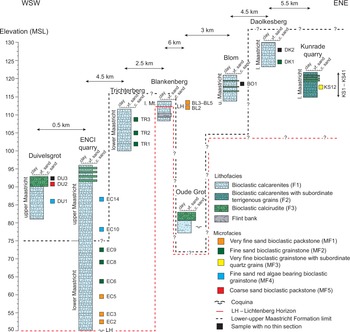

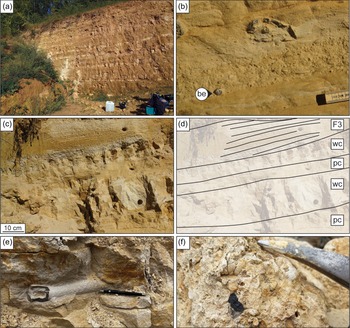


 Open access