

Introduction
Mass-casualty incidents (MCIs) are both complex and dynamic. They provide the medical incident commander (IC) a challenging environment within to navigate and to respond.Reference Abrahamsen 1 , Reference Lichtman and Nair 2 Obtaining situational awareness is key in allowing ICs to make critical decisions.Reference Abrahamsen 1 , Reference Jain, Sibley, Stryhn and Hubloue 3 It has been suggested that unmanned aerial vehicle (UAV) technology has the potential to improve the situational awareness of ICs and the safety of first responders.Reference Leduc 4 Unmanned aerial vehicles can provide ICs with capabilities including mass-gathering monitoring, delivery of medical supplies, search and rescue capability, telemetry in remote areas, and early warning of danger during operations.Reference Leduc 4 - Reference Wen, Zhang and Wong 8 In comparison to rotor-wing or fixed-wing aircraft, UAVs are faster to deploy, flexible, efficient, and customizable. The humanitarian community has been using UAVs for several years in areas of disaster mapping, information gathering, community capacity building, and logistics.Reference Boccardo, Chiabrando, Dutto, Tonolo and Lingua 9 - Reference Fornace, Drakeley, William, Espino and Cox 11 In an MCI, hazard identification and scene size-up are crucial steps in the emergency response. Knowledge of the number and types of casualties may make the triage process more efficient. One potential use of UAV technology is assisting in the triaging of casualties. By knowing their location, number, and acuity of patients, an IC can make better informed decisions regarding deployment of resources.Reference Abrahamsen 1 , Reference Pulver, Wei and Mann 12 , Reference Kurvinen, Smolander, Pöllänen, Kuukankorpi, Kettunen and Lyytinen 13 Despite a proliferation of UAV technology, no studies were found that compared UAV technology to standard practice (SP) in this context.
The purpose of this study was to compare UAV-assisted triage (UAV) to standard triage (SP) by paramedic students in triaging casualties during a simulated, multi-vehicle motor collision. The primary outcome measures examined included the total time involved in triage, the time to GREEN identification of victims, and the time the study subjects were within the scene. Secondary outcomes included triage accuracy and triage order.
Methods
Study Design
This was a randomized comparison of standard triage assisted by UAV technology versus SP triage alone in a simulated motor vehicle collision (MVC). The ethics committee for human research at Holland College, Charlottetown, Prince Edward Island, Canada approved this study.
Study Setting and Sample
A convenience sample of paramedic students was recruited to participate. Twenty second-year primary care paramedic (PCP) students were recruited to participate in a day trial and 20 advance care paramedic (ACP) students were recruited to participate in a night trial. Inclusion criteria included male and female students who were 18 years or older and in good academic standing within their respective programs. Potential participants were excluded if they opted not to voluntarily participate or were unable to complete the study. Prior to the trial, all students were provided with a 15-minute lecture on Simple Triage and Rapid Treatment (START) triage, a 30-minute UAV lecture, and a one-hour “hands on” session on UAV technology. Participation in the study was voluntary and informed/informed written consent were obtained. Following consent, students were randomly assigned to the UAV or SP groups.
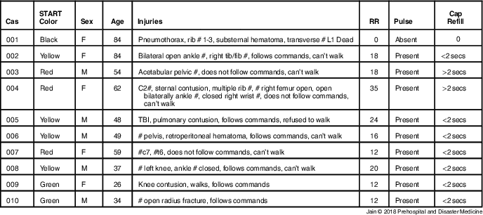
An MVC was simulated using 10 vehicles at an unused runway at an airport. The scene was based on an MVC that occurred on I-84 in Baker City, Oregon (USA) on January 17, 2015. The dimension of the scene was approximately 48.8 m x 7.6 m. All the vehicles were inspected and made safe by a designated firefighter/scene safety officer. Ten moulaged casualties were placed in the scene in a realistic fashion. Specific injuries of each patient were based on a convenience chart review of MVC trauma patients presenting to the Queen Elizabeth Hospital, Charlottetown, Prince Edward Island, Canada between January 2015 and January 2016. The simulated casualties were briefed on their physiologic state in order to provide the appropriate simulated feedback to the study participants (Table 1).
Table 1 Casualty Injuries
Unmanned Aerial Vehicle Technology
A Tornado H920 UAV (Yuneec International; Jinxi, Kunshan, China) was the UAV platform of choice based on its airtime of 24 minutes with a range of 700 m, a take-off weight of 4,990 g, and a maximum height of 4,000 m. The UAV was retro-fitted with a remote loud speaker system as well as a forward-looking infrared (FLIR) camera. From a ground station, a two-person team consisting of two professional UAV pilots was used to control both the UAV and camera separately. The pilot controlling the UAV maintained line-of-sight to ensure positive control of the UAV. Radio communication allowed the UAV pilot to adjust course based on feedback from the ground station. The ground station was based on an Android operating system (Google; Mountain View, California USA) consisting of flight control, cameral control, and a large 40-inch digital display. A special flight operations certificate was granted by Transport Canada (Ottawa, Ontario, Canada) for this study providing the necessary legal flight framework to undertake this project.
Study Flow
Study participants were randomized into two groups: either UAV or SP. Study participants were initially blinded to the study scene and were individually transported to the scenario in the back of an ambulance. Upon arrival at the scene, the PCP students were taken directly to a canvas tent so they were unable to obtain any visual information of the MVC. A brief scenario was read to them by an adjudicator informing them that the scene was safe and that they were required to identify and triage 10 casualties. Participants were then given an opportunity to clarify any issues with regard to their role, requirements, or flow of the study. A START cue card was available and encouraged for use. Participants were informed that the order in which they triaged specific casualties was at their discretion. After exiting the tent, the SP group participants proceeded directly to the scene. An adjudicator began timing the participants immediately after leaving the tent. The time GREEN patients were removed from the scene was recorded by the adjudicator. The SP group then assessed the remainder of the casualties and reported to the adjudicator their START triage color priority based on victim assessment. Triage of the casualty was considered complete when a color-priority-coded bracelet (RED or YELLOW) was placed on the casualty. The START triage level, the order of triage, and the total time to triage all 10 casualties were recorded.
The UAV group proceeded directly to the UAV ground station. Upon arrival, the UAV group directed the pilot and the camera operator in order to manipulate the UAV live video feed to gain information from the scene (Figure 1). The UAV group was able to use a microphone for the UAV loud speaker to provide walking casualties (START triaged GREEN) with instructions to leave the scene. They were also able to direct casualties on the ground to make purposeful movement in response to voice commands. Once the study participants were satisfied with the information gained from the UAV, they proceeded to the scene where they completed the triage process. Adjudicators recorded START triage priority, order of triage, and time to completion. This study was repeated at night using the second cohort of ACP students. During the night triage trial, the night SP group had access to a flashlight and ambient light at the scene. The night UAV group was able to use a FLIR camera on the UAV that would detect heat signatures within the scene (Figure 2).
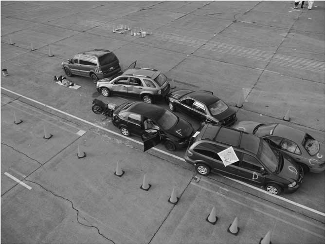
Figure 1 Example of Day Footage as Seen from the UAV. Abbreviation: UAV, unmanned aerial vehicle.
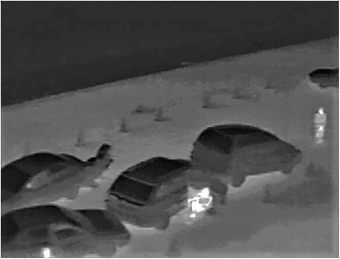
Figure 2 Low-Resolution Example of Forward-Looking Infrared (FLIR) Camera from the UAV. Abbreviation: UAV, unmanned aerial vehicle.
Measurements
GREEN identification of victims was used as one of the outcome measures as these victims could be delineated with the UAV and SP within the START triage system. The primary outcome measures included the total time involved in triage, the time to GREEN identification of victims, and the time the study subjects were on scene. Secondary outcomes included triage accuracy and triage order.
Data Analysis
For day and night iterations, statistical analysis consisted of a Wilcoxon rank sum test to compare the medians of total time to triage, time for GREEN casualties to be removed from the scene, and time on scene. Differences in triage order between the two groups were assessed statistically by a non-parametric permutation test based on the sum of squared deviations between average rank order across hazards (Stata software, Statcorp LP; College Station, Texas USA: 2013). Statistical tests had a two tailed alternative and were interpreted at a significant level of P<.05.
Results
Forty students (20 day and 20 night) agreed to participate in the study.
Day Iteration
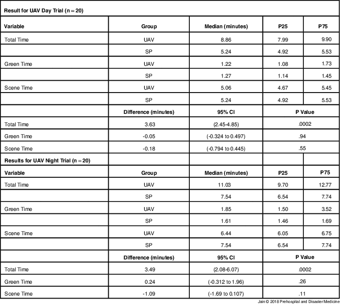
The median times to completion were 8.86 minutes (p25: 7.99 min; p75: 9.90 min) and 5.24 minutes (p25: 4.92 min; p75: 5.53 min) in the UAV and SP groups, respectfully, corresponding to a difference of 3.63 minutes (95% CI, 2.45 min-4.85 min). The difference was statistically significant (P=.002; Table 2). The median time for GREEN casualties to be evacuated from the scene was 1.22 minutes (p25: 1.08 min; p75: 1.73 min) and 1.27 minutes (p25: 1.14 min; p75: 1.45 min) in the UAV and SP groups, respectfully, corresponding to a difference of 0.05 minutes (95% CI, -0.324 min to 0.497 min). The difference was not statistically significant (P=.94). The median time on scene was 5.06 minutes (p25: 4.67 min; p75: 5.45 min) and 5.24 minutes (p25: 4.92 min; p75: 5.53 min) in the UAV and SP groups, respectfully, corresponding to a difference of 0.18 minutes (95% CI, -0.794 min to 0.445 min). The difference was not statistically significant (P=.55). The triage order was similar between both the UAV and SP groups, with permutation tests for the day trial demonstrated no statistical difference (P=.97) between both groups.
Table 2 Result for UAV Day Trial (n=20) and Results for UAV Night Trial (n=20)
Note: Total Time=time of completion; Green Time=time that GREEN casualties were removed; and Scene Time=time within in the MCI scene.
Abbreviations: MCI, mass-casualty incident; SP, standard practice; UAV, unmanned aerial vehicle.
Night Iteration
The median times to completion were 11.03 minutes (p25: 9.70 min; p75: 12.77 min) and 7.54 minutes (p25: 6.54 min; p75: 7.74 min) in the UAV and SP groups, respectfully, corresponding to a difference of 3.49 minutes (95% CI, 2.08 min-6.07 min). The difference was statistically significant (P=.002; Table 2). The mean times for GREENs to be evacuated from the scene were 1.85 minutes (p25: 1.50 min; p75: 3.52 min) and 1.61 minutes (p25: 1.46 min; p75: 1.69 min) in the UAV and SP groups, respectfully, corresponding to a difference of 0.24 minutes (95% CI, -0.312 min to 1.96 min). The difference was not statistically significant (P=.26). The mean times on scene were 6.44 minutes (p25: 6.05 min; p75: 6.75 min) and 7.54 minutes (p25: 6.54 min; p75: 7.74 min) in the UAV and SP groups, respectfully, corresponding to a difference of 1.09 minutes (95% CI, -1.69 min to 0.107 min). The difference was not statistically significant (P=.11). The triage order was similar between both the UAV and SP groups (P=.62). A trend was noted in that the UAV group spent less time on scene then the SP group. Both groups for both iterations were one-hundred-percent accurate in the level of triage.
Discussion
Many countries have regulatory bodies that govern the use of UAVs. The study was granted a special flight operations flying certificate to conduct this study. Emergency responders requiring the use of UAV technology would need to obtain a special flight operations certificate on short notice, which may not be feasible for an MCI. Emergency responders may need blanket legislation allowing them to deploy this asset on short notice, mitigating the need for permission for every incident. Although UAVs have been used in the disaster medicine context, there have been limited studies on the use of this technology in triaging casualties at an MCI.Reference Mardell, Witkowski and Spence 5 , 6 , Reference Fornace, Drakeley, William, Espino and Cox 11 This research wanted to look at the feasibility and the effect this technology would have on the triage process. The ability of the IC to gain early situational awareness in the location and types of casualties enhances their success and their response. It allows the IC to provide the appropriate resources at the correct locations benefiting casualty care. The ability to start the triage process remotely prior to arrival at the scene would greatly enhance the medical rescue capability of first responders. This study demonstrated a difference in the total time for completion of triage between the UAV and SP groups in both day and night trials. The day trial demonstrated a time difference of 3.63 minutes, with the night trial noted to have a difference of 3.49 minutes with the UAV groups taking longer. The authors believe that these differences are not clinically significant for this type of MCI. The UAV participants went to the UAV ground station first, prior to physically assessing the casualties. An alternative approach may involve paramedic teams with one team member physically on scene communicating with the other who is present at the ground station monitoring the UAV live feed. If the IC had access to the technology while en route to the scene, this difference may have been mitigated.
This study did not demonstrate a statistically significant difference in the time for those casualties triaged GREEN to be removed from the scene between the UAV and the SP groups. Using the UAV, the study demonstrated the feasibility of remotely triaging GREEN casualties. Simulation studies have demonstrated that UAVs can arrive 93% faster before Emergency Medical Services (EMS) in rural environments and 32% faster in urban environments. 14 Autonomous UAVs could be deployed automatically with dual dispatch alongside EMS.Reference Claesson, Fredman and Svensson 15 This would allow the medical IC to gather situational awareness and start triaging prior to arriving at the scene, removing those casualties classified as GREEN. The time on scene was not statistically significant between the UAV and SP groups for either the day nor night iterations. The authors believe this demonstrated that the technology does not negatively impact the triage process.
There are studies that have examined the use of the UAV technology in major incidents; however, most of these studies were descriptive in nature, case studies, or opinion pieces.Reference Abrahamsen 1 , Reference Leduc 4 , Reference Mardell, Witkowski and Spence 5 , 14 , Reference Cook, Zhao, Lee and Yim 16 - Reference Rodriguez, Geckle and Barton 18 This study is one of the first to conduct a randomized comparison study using UAV technology on simulated MVCs with casualties demonstrating the feasibility of the technology and its significance in assisting triaging casualties.
Limitations
There are design and technical limitations when considering the results of this study. First, UAVs are subject to weather, performance limitations based on battery life, and payload capability impacting their utility. The investigators noted a delay in communication between the study subject and the UAV operator due to the use of a walkie talkie between the pilot and camera operator. This could be mitigated in a future study where the study subjects are qualified both as a paramedic and as a UAV pilot providing a better understanding of UAV flight characteristics. This study had a small number of simulated casualties. A larger study with a greater number of casualties may have demonstrated a significant difference in GREEN triage and time within the scene. Overall, the number of study subjects per iteration was low. A power calculation was not used to determine a minimal sample size and a convenience sample was used. A repeat of this study with more participants may reveal differences that went undetected in this study. There are also ethical concerns with the use of UAVs. Real-time audio and video of an incident does raise concerns with regards to collection of images, privacy, and consent.Reference Cook, Zhao, Lee and Yim 16 , Reference Wesson and Humphreys 17 Finally, a simulation environment is different from the actual clinical setting, which may have distractors and other factors that are not represented by simulation formats.
Conclusion
This study demonstrated the accurate, safe, and feasible use of UAV technology in assisting in the triage of casualties at a simulated MCI scenario during both day and night. No statistical difference was noted in time to START priority GREEN casualty removal and time on scene for both day and night iterations. This demonstrate that GREEN casualties can be removed from the scene remotely. Although a difference was found in total time for both day and night iterations, there was no difference in accuracy of triage. This study was limited by a sample of convenience and the research question merits further evaluation by employing a larger sample size to verify results.


