


INTRODUCTION
The greatest number of lakes in the Northern Hemisphere occur in high and middle latitudes, reflecting the imprint of late Pleistocene glaciation and postglacial sea level rise on the modern landscape (Brosius et al., Reference Brosius, Walter Anthony, Treat, Lenz, Jones, Bret-Harte and Grosse2021). This abundance of lakes is a major asset for late Quaternary research in the Arctic and subarctic because lakes provide some of the best archives of indicators of paleoenvironmental change (Prentice, Reference Prentice, Huntley and Webb1988). In northeastern Siberia (NES; Fig. 1), lakes are generally of two types: glacial (stable basin) and thermokarst (ephemeral basin). Thermokarst basins typically occur in the northern coastal lowlands, and glacial lakes are characteristic of the mountainous interior. The regional dominance of different lake types in NES has resulted in the primary reliance on lake cores for interpreting changes in Holocene and late Pleistocene vegetation in the interior, whereas sediment exposures along river valleys and coastal cliffs comprise the main source of paleodata from the coastal lowlands (Anderson and Lozhkin, Reference Anderson, Lozhkin, Anderson and Lozhkin2002).
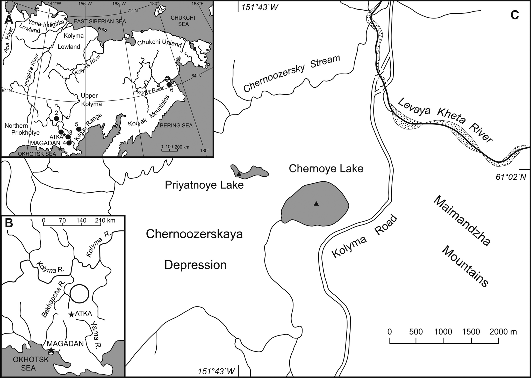
Figure 1. Maps of northeastern Siberia and the study region. (A) Map showing place names and lake sites mentioned in the text. Black circles indicate lakes: 1) Priyatnoye and Chernoye lakes; 2) Jack London Lake; 3) Elikchan-4 Lake; 4) Alut Lake; 5) Julietta Lake; 6) Alexandra Lake. (B) Map showing the location of the Upper Kolyma and Northern Priokhot'ye drainage divide. The open circle indicates the study area. The stars mark the locations of Magadan and Atka. (C) Map of Chernoozerskaya Depression showing the location of the study sites. Triangles indicate coring locales within each lake.
Not only are these two lake types separated geographically, but the geomorphic processes that have influenced basin histories generally differ as well. As the name implies, stable basin lakes are typically long-lived and associated with features of past glaciations (e.g., terminal and lateral moraines, cirques). Although occurring in areas of continuous or discontinuous permafrost, these basins typically are unaffected by thermokarst processes. While lake levels can be affected by shifts in drainage patterns or in climate, these basins generally remain extant after their initial formation. In contrast, the establishment and persistence of thermokarst lakes are dependent on numerous factors (e.g., vegetation cover, sediment supply, topography, climate) and such lakes typically have a complex geomorphic history (Edwards et al., Reference Edwards, Grosse, Jones and McDowell2016). This history can include lake migration and mixture of lake sediments through ice melt and slumping of older material from lakeshore embankments (see Background for more detail). Such processes make these types of lakes unreliable sources for interpreting paleovegetation and other ecosystem changes because of the mixed nature of their deposits.
While the undisturbed sediment records from stable basin lakes remain key for interpreting paleoenvironments, understanding processes associated with thermokarst landscapes has taken on a new significance as modern studies have begun to investigate the importance of melting permafrost to future carbon budgets as global climates warm (Bowden, Reference Bowden2010; Romanovsky et al., Reference Romanovsky, Drozdov, Oberman, Malkova, Kholodov, Marchenko and Moskalenko2010; Schuur et al., Reference Schuur, McGuire, Schädel, Grosse, Harden, Hayes and Hugelius2015; Biskaborn et al., Reference Biskaborn, Smith, Noetzli, Matthes, Vieira, Streletskiy and Schoeneich2019). Permafrost melt is influenced in two major ways: 1) broadscale, top-down thawing related to increasing air temperature; and 2) more localized thawing related to thermokarst activity (Schuur et al., Reference Schuur, McGuire, Schädel, Grosse, Harden, Hayes and Hugelius2015). Of the two methods, thermokarst results in more abrupt and deeper thawing. Much of the permafrost in the arctic is predicted to melt over the next 50–100 years, and recent increases in thermokarst activity is probably a major contributor to the disappearing permafrost (Bowden, Reference Bowden2010).
The intermontane lowlands that occur in the interior of NES combine geomorphological elements of both the organic-rich deposits of the coastal lowland and the glacial imprint of the mountain valleys. They also are underlain by continuous or discontinuous permafrost. The first sediment core taken in NES was from Chernoye Lake in the Chernoozerskaya Depression (Fig. 1). Despite the presence of glacial moraines near the lake, the homogeneity of the sediments and the palynological record indicate a depositional history dominated by thermokarst processes. A second coring expedition to Priyatnoye Lake (Fig. 1), located 550 m to the northwest of Chernoye Lake, was undertaken in 1999 to: 1) further assess the geomorphological influences on lake origin and development in the tectonic depressions of NES and 2) if stable basins existed to obtain a paleovegetation record that could be compared to the regional vegetation history. A later, independent investigation of freshwater ecosystems provided a series of photographs taken between 2005 and 2020 that illustrates the catastrophic impact of recent thermokarst processes on Priyatnoye Lake.
In this paper, we examine the palynology and lithology of the Priyatnoye core for interpreting vegetation and lake basin history. We also provide a summary of results from the research at Chernoye Lake to provide a more complete understanding of lake histories within the Chernoozerskaya Depression. Bowden (Reference Bowden2010) noted that while thermokarst activity at a specific site may be “an interesting oddity,” over longer time and space scales, thermokarst processes have significant impacts on multiple aspects of the northern landscapes. Although only a single site, the Priyatnoye research underscores Bowden's (Reference Bowden2010) point by showing the catastrophic impact of thermokarst processes on a basin of long term stability in an area where thermokarst landscapes are rare.
STUDY AREA AND BACKGROUND
Thermokarst lakes: origins and development
Thermokarst lakes occur in areas with continuous syngenetic permafrost. The presence of subaerial ice wedges causes the formation of polygonal patterning on the land surface (Hopkins and Kidd, Reference Hopkins, Kidd and Senneset1988; Grosse et al., Reference Grosse, Jones, Arp and Shroder2013; Edwards et al., Reference Edwards, Grosse, Jones and McDowell2016). Small ponds and boggy surfaces often develop in the slight depressions in the center of the polygons. The relative warmth of the water as compared to the underlying frozen sediments results in local ice melt. As the ice melt continues, the original small pool expands to form a lake. Prevailing winds, which preferentially melt ice along the downwind shoreline, can cause the migration of the lake across the land surface and/or alter the lake's outlet by the slumping of thawed sediments adjacent to the lake shore. The movement of the lake can result in its merger with another lake or a connection with nearby stream channels, causing the full or partial drainage of the original basin. If the lake is located near a coast, drainage also can be caused by the destruction of coastal scarps, which in NES typically consist of ice-rich yedoma formations (Pleistocene-age fine-grained sediments with syngenetic ice wedges; Strauss et al., Reference Strauss, Schirmeister, Grosse, Fortier, Hugelius, Knoblauch and Romanovsky2017). These processes can either cause a rapid drainage of the lake (e.g., stream intersection, collapse of coastal bluffs) or a more gradual drainage and exposure of the original lake basin (e.g., lake migration). In areas where the lake bottom is exposed, ice-wedge growth once again is initiated, polygonal relief develops on the land surface, and the above processes associated with these dynamic permafrost systems begin anew. At this point, however, epigenetic permafrost dominates, and ice content is probably lower. Such processes result in mixed and contaminated records, thereby limiting the use of paleobotanic records from thermokarst lakes for reconstructing the paleovegetation.
Modern settings of the Chernoozerskaya Depression and Upper Kolyma region
The Chernoozerskaya Depression (Fig. 1), located along the southern edge of the Upper Kolyma basin, lies within the western Maimandzha Mountains, which are ~140 km long, and have peaks of ~1400–1600 m asl (above sea level). This intermontane lowland lies ~20 km to the north of the East Siberian Sea–Okhotsk drainage divide and extends ~10 km from east to west and ~8 km from north to south. It is bounded by the Levaya Kheta River to the north, a series of smaller river valleys to the south, and by Chernoozersky Stream to the west and northwest. The Chernoozerskaya Depression itself is characterized by a hilly surface varying between 820 m asl and 800 m asl (Fig. 2), with elevations decreasing slightly from north to south.

Figure 2. Photographs of: (A) view eastward across the Chernoozerskaya Depression. Priyatnoye Lake is in the foreground and shows the lowered lake level in the eastern basin. Chernoye Lake lies ~550 m east of Priyatnoye Lake, and the Levaya Kheta River and Maimandzha Mountains are seen in the distance. Larix cajanderi–Pinus pumila forest outlines the moraine ridges, and the boggy lowlands are dominated by graminoids and Salix shrub thickets. Photograph taken by K.V. Regel on July 24, 2021. (B–D) Images from Google Earth showing Priyatnoye and Chernoye Lakes within the Chernoozerskaya Depression, and separation of Priyatnoye Lake into its eastern and western basins over time: (B) image from July 2005, lake configuration similar to that described during coring in 1999; (C) image from July 2021, lake configuration shows the formation of two distinct lakes; and (D) image from July 2019, close-up of the eastern and western basins of Priyatnoye Lake.
The study area has a marked coast-to-interior climatic gradient. Mean January and July temperatures in Atka (Fig. 1), located ~21 km to the south of Priyatnoye Lake, are −26°C and 17°C, respectively (http://www.weather-atlas.com/en/russia/atlas-climate; accessed September 7, 2021); however, minimum temperatures in December through February can drop to −55°С and the warmest days in July can reach 25°С. Average annual precipitation in the area is 395 mm (http://www.meteo-tv.ru/rossiya/magadanskaya-obl/atka, accessed September 6, 2021; meteorological data from the Kolyma Meteorological Center, Magadan), and almost half of the annual precipitation occurs in the summer months (June, July, August; 182 mm). In the study area, July is the rainiest (74 mm) month and March (11 mm) is the driest month. By contrast, Magadan, located on the Okhotsk coast ~152 km to the south of Atka, has mean January and July temperatures of −16.4°C and 14.8°C, with mean annual minima and maxima of −26.2°C (January) and 21.5°C (July; http://en.wikipedia.org/wiki/Magadan). Mean January and July precipitation in Magadan is 14 mm and 64 mm, respectively, the wettest month is August (93 mm), and driest conditions occur in February (13 mm).
The Upper Kolyma drainage falls within the continuous permafrost zone (Kotlyakov and Khromova, Reference Kotlyakov and Khromova2002). Permafrost features within the Chernoozerskaya Depression include ice wedges, ice-wedge polygons, thermokarst lakes, and baydzharaks. Baydzharaks, which create some of the more striking aspects of the Chernoozerskaya Depression's geomorphology, are formed when unconsolidated sediments are dissected by thermal erosion and related thermokarst processes, resulting in the formation of ravines and pillar-like remnants of sediments. The pillars, or baydzharaks, originally were the cores of ice-wedge polygons. These structures are like those found bordering the rivers in the Kolyma Lowland and along coastal areas of the East Siberian Sea (Sher et al., Reference Sher, Kaplina, Giterman, Lozhkin, Arkhangelov, Kiselyov, Kouznetsov, Virina and Zazhigin1979).
Vegetation in the southwestern part of NES belongs to the North Okhotsk province of the boreal floristic zone (Yurtsev, Reference Yurtsev1974), which was further divided by Khokhryakov (Reference Khokhryakov1976) into two zones corresponding to the Coastal-Okhotsk and Okhotsk-Kolyma watersheds. The climate and flora of both zones are greatly influenced by the proximity of the Okhotsk Sea. The Okhotsk–Kolyma region is considered to be “transitional between the offshore Okhotsk region and the more continental Kolymsky” (Khokhryakov, Reference Khokhryakov1976, p. 9; translated by A.V. Lozhkin). In the Okhotsk–Kolyma region, open forests of Larix cajanderi dominate, with an altitudinal limit of 800–850 m asl in the mountains near the Okhotsk–Kolyma drainage divide, dropping to 400–500 m asl in coastal areas near the Okhotsk Sea. The shrub understory in these forests consists mainly of Pinus pumila, Betula middendorffii, Alnus fruticosa, and Salix sp. Betula platyphylla grows within the Larix forest, and this tree can form pure stands along river courses. Populus suaveolens–Chosenia arbutifolia forests with a lesser component of Populus tremula are characteristic of the coarse-grained floodplain deposits of the river valleys. Beyond the main forest boundary, higher slopes support Pinus pumila mixed with Alnus fruticosa and Betula middendorffii and a scattering of Larix cajanderi. The highest parts of the ridges support a discontinuous herb–subshrub tundra, with a lower elevational limit of ~900–1000 m asl.
Geological setting
Study of the Chernoozerskaya Depression's geology began with the building of the Kolyma Road (Fig. 1C) between 1932 and 1953. These early investigations focused both on natural outcrops and material exposed in borrow pits, the latter excavated to provide material for the road and for use in building of maintenance facilities in Atka. The Chernoozerskaya Depression is of Pliocene age, and is bordered to the east by a low-mountain massif composed of Lower Cretaceous tuffs (Glushkova, Reference Glushkova and Simakov1983). Outcrops of Lower and Middle Jurassic siltstone and shale that are crosscut by andesitic dikes are present along the northern and western flanks of the Chernoozerskaya Depression. Exploratory drilling showed that the thickness of the unconsolidated sediments filling the Chernoozerskaya Depression can exceed 100 meters (O. Yu. Glushkova, personal communication, October 2021). These deposits are of alluvial, lacustrine, glacial, and glacio-fluvial origins.
During MIS 2, valley and cirque glaciers in the Upper Kolyma reached maximum lengths of 10–20 km and widths of 2–3 km (Glushkova, Reference Glushkova and Simakov1983; Anderson et al., Reference Anderson, Belaya, Glushkova, Lozhkin and Gagiev1997; Brigham-Grette et al., Reference Brigham-Grette, Lozhkin, Anderson, Glushkova and Madsen2004). The thickness of the largest of these glaciers probably did not exceed 250–300 m. In contrast, MIS 4 glaciers often extended beyond the mountain valleys into nearby tectonic depressions.
Chernoye Lake: the first lacustrine core from NES
The first lake coring research in NES was conducted at Chernoye Lake (61°01′59.4″N 151°43′21.2″E; 853.8 m asl; Figs. 1, 2) in spring of 1984 (Note: the following information is from A. Lozhkin, field and laboratory notes). Chernoye Lake is the largest lake in the Chernoozerskaya Depression, measuring ~1450 m by ~750 m, is fed by seasonal streams, and the lake basin is flat-bottomed, with a water depth of 460 cm in its center. The lake outlet is ~5.5 km long, has intermittent flow, and is a tributary to the Bassandra River. The outlet valley, which is up to 2 km wide, is characterized by clearly expressed polygonal microrelief with small lakes or pools in the centers of the ice-wedge polygons. The vegetation near the lake is open Larix forest with a shrub undergrowth that includes Betula spp., Alnus fruticosa, Pinus pumila, and Salix spp. Graminoid communities dominate in wet to mesic low-lying areas, and nearby hill slopes support Betula shrub thickets. Except for the southern and part of the eastern shores of the lake, the area immediately adjacent to the modern basin is relatively flat, swampy, and covered with Cyperaceae-dominated communities.
Finely bedded lacustrine silts and fine-grained sands, which include ice wedges with roots that extend beneath the water's edge, are exposed in a 12- to 15-m-high outcrop on the southern shore of Chernoye Lake. This outcrop, which is >100 m long, includes five baydzharaks separated by thermokarst ravines up to 20 m wide. The thermokarst ravines formed when the ice wedges melted, and the thawed, liquified sediments moved downslope to the lake. As noted previously, this outcrop pattern is similar to those seen in coastal areas and river valleys of the northern lowlands. In the upper parts of the baydzharaks, the sediments form almost vertical walls that are 3–5 m high. The lower part of the outcrop is covered by talus due to the slippage of the moisture-saturated, thawed deposits. On the surface of the outcrop, ice wedges form a polygonal microrelief with small and shallow gullies.
Chernoye Lake was chosen for the first experiment with lake coring in NES because of its easy access from the Kolyma Road. There were no lightweight corers available at the time so instead, drilling equipment was mounted on an open-bed truck and used to drill through the ice-covered lake surface in order to raise a single-drive, 285-cm-long sediment core from the lake's center (Fig. 1C). Although there was evidence of active permafrost activity in the Chernoozerskaya Depression, the large size of the lake and a water depth of 460 cm at the coring site suggested that thermokarst processes may have had a minimal impact on the lake basin.
The core was dominated by silts, indicating a lacustrine origin. However, the homogeneity of the core sediments suggested post-depositional mixing. Furthermore, the pollen spectra showed no significant variations in the percentages. Such uniformity in lithology and palynology is typical of thermokarst basins, and results from the mixing and contamination of lacustrine sediments by the slumping of shoreline banks and/or migration of the lake related to thawing of buried ice along the lake's margins (Edwards et al., Reference Edwards, Grosse, Jones and McDowell2016). The presence of moraines near Chernoye Lake probably limited any significant migration or drainage of the basin and suggests that shoreline slumping as ground ice melted was the primary reason for the lithological and palynological uniformity seen in the sediment core.
The pollen taxa, dominated by Betula, Alnus, and Pinus, indicate a possible early Middle Holocene age for the Chernoye sediments (Anderson and Lozhkin, Reference Anderson, Lozhkin, Anderson and Lozhkin2002). Irregular inclusions of tephra found in the core suggest that the basin was present at least by the early Middle Holocene. Although a geochemical analysis was not done, this tephra is the same color and texture as the Kuril Island tephra, locally known as the Elikchan tephra (Ponomareva et al., Reference Ponomareva, Kyle, Melekestsev, Rinkleff, Dirksen, Sulerzhitsky, Zaretskaia and Rourke2004; Lozhkin et al., Reference Lozhkin, Brown, Anderson, Glushkova and Meleketsev2016), which was dated to 7650 ± 50 14C yr BP (ca. 8440 cal yr BP). Although available data suggest thermokarst processes were active in the Chernoozerskaya Depression by at least ca. 8500 cal yr BP, lake formation most likely occurred earlier caused by the initiation of thermokarst processes associated with climate warming beginning ca. 14,800 cal yr BP (Lozhkin, Reference Lozhkin and Gagiev1997; Anderson and Lozhkin, Reference Anderson, Lozhkin, Anderson and Lozhkin2002).
Priyatnoye Lake: setting and previous research
Although results from the Chernoye Lake core were disappointing, a need remained to describe the vegetation history of the tectonic depressions in southern NES to determine possible differences compared to records from the mountain valleys (e.g., the presence of glacial refugia in the intermontane lowlands). Priyatnoye Lake (61°01′59.4″N; 151°43′21.2″E; 890 m asl), which is located 550 m to the northwest of Chernoye Lake in a shallow, east–west trending valley (Figs. 1, 2), provided another candidate site for retrieving a late Pleistocene to Holocene history from the Chernoozerskaya Depression. Priyatnoye Lake is bordered to the south by a flat-surfaced ridge (~893 m asl) that is covered by a mix of sand and gravel and contains both angular and well-rounded pebbles and boulders, suggesting its origin as a moraine. In August 1995, Priyatnoye had a maximum length of ~800 m and a maximum width of ~200 m. The lake consists of two basins with no inlet and a single seasonal outlet. The eastern basin of the lake has an irregular bottom consisting of a series of north–south trending troughs varying between ~2 m and 6 m in depth. A circular, flat-bottomed basin occurs in the northwest portion of the lake and was the site for the lake coring.
Vegetation near Priyatnoye is like that described for Chernoye Lake except that Pinus pumila is abundant on hillslopes near the smaller lake. Locally, Ericales are plentiful and Betula forms extensive thickets around the lake. Salix shrubs are found scattered along the lake shoreline. Aquatic plants are common, especially in the shallows in the western part of the lake, and include Arctophila fulva, Hippuris vulgaris, Ceratophyllum sp., and Potamogeton spp.
In 1998, a team of parasitologists from the Institute of the Biological Problems of the North began a study of the species diversity of parasitic worms whose life cycles are associated with Gammarus lacustris. Gammarus, which resembles a freshwater shrimp, is a key indicator species of the health and stability of freshwater ecosystems, as well as being an intermediate host for helminths and an important food source for birds and fish. In the case of the Chernoozerskaya Depression, Gammarus is important for the successful reproduction of Melanitta deglandi. Although G. lacustris was found in both Chernoye and Priyatnoye lakes, the presence of many small fish, such as Pungitius pingitius, Phoxinus phoxinus, and more rarely Thymallus arcticus and Barbatula toni, in Chernoye Lake, and an abundance of fish-eating birds (e.g., Sterna hirundo, Gavia arctica) in the Depression, resulted in a relatively low crustacean population when compared to Priyatnoye Lake, where fish are absent. Thus, Priyatnoye Lake became the focus of a longer-term field investigation. By June 2009, the western and eastern parts of the Priyatnoye basin showed a sufficient decline in water level to preclude the survival of Gammarus lacustris because the subarctic species requires a minimum water depth of 3 m (see Results). As a result, Melanitta deglandi, which previously had nested annually near the lake, moved to another area and the study at Priyatnoye was terminated.
METHODS
Sediment cores were recovered in summer 1999 from both basins of Priyatnoye Lake using a modified Livingstone piston sampler (Wright et al., Reference Wright, Mann and Glaser1984). In the western basin, paired cores were raised (Figs. 1C, 2D). The uppermost 70 cm of flocculent sediments were recovered with a plexiglass tube. This short core was correlated with the adjacent 385-cm-long Livingstone core based on core depths and pollen content. During the initial lake reconnaissance in 1998, sediment samples from the upper 250 cm of an exposed moraine that borders the lake were taken for paleobotanical analyses. Water depths at Priyatnoye Lake were recorded in August 1995 using readings from a fish finder and select measurements were confirmed using a measured plumb line. These depth measurements focused on locating the best coring sites in the eastern and western basins of Priyatnoye Lake. At the time of the field work, GPS control was unavailable for individual data points so it was not possible to construct a detailed bathymetric map. Drops in lake level were estimated by comparing the previous shoreline, indicated by the dead remains of shallow aquatic plants, to the current shoreline.
A set of five accelerator mass spectrometry (AMS) dates and the age of the Elikchan tephra were used in developing an age model for the Priyatnoye Lake core (Table 1). Radiocarbon dates were converted to calibrated ages using the IntCal13 calibration curve in CALIB 8.2 (Stuiver and Reimer, Reference Stuiver and Reimer1993; Stuiver et al., Reference Stuiver, Reimer and Reimer2020). An age-depth model was constructed with BACON ver. 2.3 (Blaauw and Christen, Reference Blaauw and Christen2011; Fig. 3). This program divides the paleorecord into a specified number of sections based on user-defined core characteristics, then estimates accumulation rates using Bayesian statistics. All ages in the text, excepting calendar ages associated with the recent changes in lake level, are presented as calibrated years before present (cal yr BP).

Figure 3. Age model for Priyatnoye Lake created using Bacon age-modeling software (Blaauw and Christen, Reference Blaauw and Christen2011; http://www.chron.qub.ac.uk/blaauw/bacon.html, accessed July 15, 2022); bottom panel shows calibrated ages and age-depth model where the black curve indicates the optimal model based on weighted mean ages and the gray stippled portion indicates 95% confidence intervals. Upper left panel: history of Markov Chain Monte Carlo iterations; upper middle panel: distributions for the accumulation rate illustrating prior (gray line) and posterior (gray infilled curve) distributions; upper right panel: distributions for memory illustrating prior (gray line) and posterior (gray infilled curve) distributions. Note that age assignments younger than 3760 cal yr BP are based on linear interpolation of the sedimentation rate between 111 cm and 181 cm and should be considered tentative.
Table 1. Radiocarbon, tephra, and calibrated ages used in the Priyatnoye Lake age model.

* see Ponomareva et al., Reference Ponomareva, Kyle, Melekestsev, Rinkleff, Dirksen, Sulerzhitsky, Zaretskaia and Rourke2004; Lozhkin et al., Reference Lozhkin, Brown, Anderson, Glushkova and Meleketsev2016
Palynological samples from the lake core and the moraine were processed following standard procedures for Arctic and subarctic sites (PALE, 1994). The programs Tilia and Tilia-graph (http://www.tiliait.com) were used for calculating percentages and plotting the data. The percentages of individual pollen taxa are based on a sum of arboreal and nonarboreal pollen, with spores expressed as a percentage of the same sum (Figs. 4, 5). The subsum percentages on the left of the diagram are calculated using a sum of pollen and spores. All pollen sums exceeded 300 identified arboreal and nonarboreal taxa, with most samples having sums between 500–600 grains. The pollen record was divided into zones using the constrained incremental sum of squares method (CONISS). Plant taxonomy follows Czerepanov (Reference Czerepanov1995) except for Duschekia fruticosa. To avoid confusion, this shrub is referred to as Alnus in the text following standard palynological rather than botanical nomenclature. Pinus subgenus Haploxylon pollen represents Pinus pumila.

Figure 4. Percentages of (A) major and (B) minor pollen and spore taxa, Priyatnoye Lake. Dark circles indicate taxa that are ≤2% of the assemblage. The lack of an herb-dominated pollen zone characteristic of MIS 2 assemblages from Beringia indicates a hiatus between zones PR 1 and PR 2. The key to the lithological units in (A) is: 1) silt with abundant plant macrofossils; 2) mix of tephra and silt layers; 3) mix of silt, sand, and gravel with occasional plant macrofossils. Triangles indicate the presence of Larix needles. The black bar between the age and lithology columns represents the interval where layers and inclusions of tephra were found. Schlier structure occurs between 336 cm and 385 cm. See Table 2 for more details.

Figure 5. Percentages of major pollen taxa from the Priyatnoye moraine (PRM) locality. The lithology is a mix of sandy loam and angular pebbles and gravel. The volume of coarse material decreases in the upper portion of the section. See Table 2 for more details. Dark circles indicate taxa that are ≤2% in the assemblage.
Table 2. Lithology of Priyatnoye Lake and bordering moraine.

RESULTS
Palynological results: Priyatnoye Lake and bordering moraine
Several exploratory cores were obtained across the eastern basin of Priyatnoye Lake in 300–600-cm-water depth. All cores indicated a maximum sediment accumulation of 35 cm in this part of the lake. Sediments were gray, water-rich silts with fine organic matter. Given the short length of the record of sedimentation, no further analysis was done on this material.
The western basin of Priyatnoye Lake is characterized by a flat-bottomed area of ~100 m x 100 m, with a water depth of 3.5 m. The paired cores used in the palynological analysis were raised in the central part of this western basin (Figs. 1C, 2D). The age model was based on calibrated AMS radiocarbon dates between 111 cm and 331 cm (Table 1). Because of the depositional hiatus, the ca. 28,800 14C yr BP (33,190 cal yr BP) date was not used in age modeling. Age assignments for the upper 110 cm of the core (i.e., younger than 3490 ± 40 14C yr BP or 3760 cal yr BP) are based on linear interpolation of the sedimentation rate between 111–181 cm. These ages should be considered as tentative.
The lithology of the record from the western basin is dominated by silts with coarser sediments in the bottom portion of the core (Table 2). The volcanic ash layer (277–291 cm) has a complex structure that is not typical of other lacustrine sites in the mountain regions of the Indigirka–Kolyma drainage and in Northern Priokhot'ye (Anderson and Lozhkin, Reference Anderson, Lozhkin, Anderson and Lozhkin2002; Lozhkin et al., Reference Lozhkin, Brown, Anderson, Glushkova and Meleketsev2016). In these areas, the Elikchan tephra typically occurs as a continuous layer with distinct horizontal upper and lower boundaries. While the tephra in the Priyatnoye core has well-defined horizontal boundaries, the ash horizon itself includes a layer of silt (277.2–278 cm) and silt with scattered inclusions of tephra (inclusions ~1.2 cm x 0.8 cm; 284–287.5 cm).
Four pollen zones were defined in the Priyatnoye Lake record (Fig. 4). The palynological spectra of zone PR 1 (385–336 cm; MIS 3) are dominated by Betula (up to 39%), Alnus (12–29%), and Pinus pumila (up to 23%) pollen. Although the growth form of Betula cannot be distinguished based on pollen morphology, the lack of Larix and relatively high percentages of graminoid and forb pollen suggest that Betula probably occurred as shrubs. Poaceae, Cyperaceae, and Artemisia are the dominant herbaceous taxa, with an additional 27 herb types occurring in trace amounts throughout the zone. Sphagnum is the most common spore, with minor occurrences of Selaginella rupestris, Lycopodium spp., Polypodiaceae, and Bryales.
Zone PR 2 (336–317 cm; ca. 14,000–12,200 cal yr BP;) is distinguished by high percentages of Betula pollen (~47%). Alnus (up to 20%), Poaceae (5%), and Cyperaceae (10%) pollen remain as important contributors to the assemblage, although the first two taxa have lower percentages compared to zone PR 1. Pinus s/g Haploxylon (representing Pinus pumila), Artemisia, and minor herb taxa (18 types) also decrease from zone PR 1. Sphagnum, Selaginella rupestris, and Polypodiaceae are the only spores appearing in zone PR 2.
Zone PR 3 (317–280 cm; ca. 12,200–10,100 cal yr BP) is characterized by maximum pollen percentages of Alnus (~63%) and Betula (47–58%) in the lower and upper portions of the zone, respectively. As in zone PR 2, minor herbs (16 types) and spores (Lycopodium ssp., Selaginella rupestris, Polypodiaceae) occur in low percentages.
Zone PR 4 (280–0 cm; ca. 10,100–0 cal yr BP) is marked by a sharp rise in Pinus pollen and the first appearance of Larix pollen. The percentages of Pinus change from 12% at the base of the zone to 38% at midzone (the latter being the maximum for the lake sediments), followed by a decrease to ~20–25% above the radiocarbon date of 3490 ± 40 14C yr BP (111–112 cm). Total herb percentages are low (~10–15%), but the number of minor herb taxa (31) are the maximum for the core. Sphagnum spore percentages increase above 190 cm, with the highest percentages (up to 22%) occurring between the top of the core and 80 cm. Selaginella rupestris and Polypodiaceae are the most common minor spore types.
Palynological analysis of the moraine deposits was limited to the upper 180 cm of sandy loam because coarse sediments from 180–250 cm had low pollen concentrations and did not provide reliable counts. The pollen diagram from the moraine was divided into three pollen zones (PRM; note that zone PRM3 is defined by a single surface sample; Fig. 5). Betula pollen dominates in all spectra, although the lowest percentages are registered in the uppermost and basal samples (~28%). Betula percentages rise throughout zones PRM1 (180–115 cm) and PRM2 (115–55 cm) to a maximum of 61%. Alnus percentages are below 20%, except at the top of the sampled interval (25%). Percentages of Pinus pollen vary, although they are always <22%, with maximum values in the surface sample (34%). Larix pollen occurs sporadically in trace amounts throughout the record. Herb pollen is consistently ~10% of the total sum of pollen and spores. The lowermost zone is dominated by spores from Selaginella rupestris and Bryales. These spore types decline in zone PRM2, whereas Polypodiaceae spores increase. Sphagnum is the only spore registered in zone PRM3.
Recent lake level changes, Priyatnoye Lake
Parasitology field work conducted in August 2005 documented a basin similar in size to that noted in 1999 (Fig. 6A). A dramatic decline in lake level occurred by |June 2009 (Fig. 6B). The drop in the western basin was ~1 m, estimated by comparing the location of the water's edge in 2009 to the previous lake margin, the latter indicted by a fringe of dead aquatic plants. The surface area of the western basin was roughly halved, with water levels remaining constant until July 2021, the time of the last observation of the lake. The estimated decline in the eastern basin (Fig. 6C) was ~1.5 m in 2009, with an additional decrease of ~0.5 m by June 2010. By June 2009, several bowl-shaped depressions, or sinkholes (Fig. 6D), had formed along the northern shore of the eastern basin. By September 2014, the lake level had risen (Fig. 6E), approximating the level noted in 2009. In August 2020 and July 2021, the lake level remained as low or perhaps slightly lower than that noted in 2010. In July 2020, water filled the sinkholes that were first noted in summer 2009, but the level dropped by ~0.5 m by July 2021 (Fig. 6F).

Figure 6. Photographs of Priyatnoye Lake showing lake level changes between 2005 and 2021: (A) image from August 18, 2005, of the eastern part of the Priyatnoye Lake basin from the northeastern shore, illustrating an interval of relatively high lake levels. Water level is similar to that noted in 1995 during a reconnaissance of the region to find lakes suitable for coring. (B) image taken June 20, 2009, of the western part of the Priyatnoye Lake basin following a decrease in the water level of ~1 m, exposing much of the lakebed. The water level in the eastern basin (not shown) fell by ~1.5 m. (C) image taken June 14, 2010, of the eastern basin taken from the same area as in (A). The water in the eastern basin had dropped another ~0.5 m from the 2009 level. (D) image taken June 21, 2009, of the northern shore of the eastern basin, showing bowl-like depressions (sinkholes), in the exposed lakebed that likely were areas of drainage caused by melting of underlying ice wedges. (E) image taken September 3, 2014, of the eastern basin of the lake from the eastern shore. The 2014 water level approximates that seen in 2009. The rise in the water level most likely was due to abundant precipitation in summer 2014. (F) image taken July 3, 2020 of the northern shore of the eastern basin near the sinkholes shown in (D). By July 24, 2021, the water level in the sinkhole dropped by 0.5 m. Photographs by K.V. Regel.
DISCUSSION
History of the Priyatnoye basin
The zone PR 1 assemblage (Fig. 4), dominated by Betula, Alnus, and Pinus pollen, suggests that Priyatnoye Lake initially formed during a mild climatic interval. However, the basin's origin is likely linked to glacial processes. The ridge that borders the lake to the south has lithological (mix of coarse-grained sediments) and palynological (specifically high percentages of Selaginella rupestris spores; Fig. 5) characteristics associated with late Pleistocene moraines (Vaskovsky, Reference Vaskovsky1956, Reference Vaskovsky1957; Brigham-Grette et al., Reference Brigham-Grette, Lozhkin, Anderson, Glushkova and Madsen2004). Late Pleistocene glaciation in this region of the Upper Kolyma was limited during MIS 2 to cirque glaciers in the nearby Maimandzha Mountains (Glushkova, Reference Glushkova2001; Brigham-Grette et al., Reference Brigham-Grette, Lozhkin, Anderson, Glushkova and Madsen2004), whereas MIS 4 glaciers were more extensive, spreading down mountain valleys into the Chernoozerskaya Depression. The pollen stratigraphy and radiocarbon date suggest that the base of the Priyatnoye core most likely dates to later in the Karginsky interstade (MIS 3-equivalent), and that the nearby moraine formed during the Zyrian glaciation (MIS 4-equivalent), a conclusion that is consistent with the regional geology.
The absence of an herb-dominated pollen zone, which is a hallmark of MIS 2 pollen records across NES (Lozhkin and Anderson, Reference Lozhkin, Anderson, Elias and Mock2013), suggests that the lake perhaps was constantly ice-covered during this late Pleistocene stade, thereby eliminating or severely reducing sediment input to the basin. Alternatively, the lake may have dried up completely or was reduced in area (i.e., part of the basin continued to hold water, while the area where the core was taken had become subaerial) during the full glaciation. With either a relatively low lake level or with lake drainage possibly related to thermokarst activity during MIS 3, the insolating effects of the water column would be negated, resulting in freezing of the underlying sediments. Subsequent freezing and thawing led to the formation of a blocky sediment structure (336–385 cm) that is characteristic of schlier deposits and is reminiscent of peds formed in silty and clayey soils caused by ice segregation and cryoturbation (Van Vliet- Lanoë, Reference Van Vliet-Lanoë1982). Similar structures have been noted in lake cores from Alaska (Edwards and Brubaker, Reference Edwards and Brubaker1986).
Sediments began to accumulate again sometime after ca. 14,000 cal yr BP, reflecting the renewed inflow of waters to the basin, most likely from increasing precipitation related to postglacial climatic amelioration (Lozhkin, Reference Lozhkin and Gagiev1997; Anderson and Lozhkin, Reference Anderson, Lozhkin, Anderson and Lozhkin2002). This radiocarbon age is consistent with the high percentages of Betula and Alnus pollen (zones PR 2 and PR 3) characteristic of regional pollen assemblages.
As noted in the Results section, the discontinuous structure of the Elikchan tephra is unlike the well-defined horizontal layers found in other lakes (e.g., Elikchan-4, Jack London; Fig. 1A). This discrepancy suggests either there was post-depositional mixing of the tephra, as would occur in a thermokarst basin, or a mixed in-wash of tephra and silt from an elevated lake shore or from an inflowing stream that was active at the time. The PR 3–PR 4 zone boundary, which occurs near the tephra, suggests that there was no significant sediment mixing as is typical of thermokarst lakes. In the upper 277 cm of the core, plant macrofossils are abundant, which is also a characteristic of thermokarst lakes. However, the rise in Sphagnum spores in the upper half of zone PR 4 and the more subtle changes in Pinus pollen suggest that the western part of the lake was a stable basin throughout the Holocene. Although changes in lake levels may have occurred (perhaps related to thermokarst activity in the eastern basin), the Priyatnoye record lacks a clear lithological or palynological signal of such lake level variations (Edwards et al., Reference Edwards, Grosse, Jones and McDowell2016). Nonetheless, differences in sediment thickness between the eastern and western basins (~35 cm vs. 385+ cm, respectively) suggest that thermokarst activity has had a long term effect on the lake's history. Such a discrepancy indicates that the eastern basin is younger (less time for sediments to accumulate) and formed as buried ice wedges melted; and/or was drained sporadically with subaerial ice melt in contrast to a more continuous lake presence in the western basin.
Recent observations at Priyatnoye Lake support the latter interpretation of sporadic drainage with subaerial ice melt, and demonstrate how quickly and catastrophically lake basins can be affected by thermokarst processes. Photographs taken in August 2005 during the Gammarus study showed the lake size and water level (Figs. 2B, 6A) approximated that described in 1995 and 1999 during lake-coring work. However, by June 2009, a major change had occurred that resulted in the formation of two separate lakes. The drop in water level as measured at various spots along the lake shoreline was ~1 m in the western basin and ~1.5 m in the eastern basin. Additionally, the surface area in the western basin decreased approximately by half. Because no field work was done between 2005 and 2009, it is uncertain when this change occurred or whether it was gradual or rapid.
Lake level in the western part of Priyatnoye has since remained stable, at least up to July 2021, our last visit to the site (Fig. 2). However, water depth in the eastern basin in June 2010 had decreased by another ~0.5 m. Bowl-shaped depressions or sinkholes (Fig. 6C) formed on the exposed bottom near the northern shore of the eastern basin, and several shallow channels suggest that water was flowing from the western basin to these sinkholes. Within the past decade, water levels in the sinkholes have varied, as has the lake level in the eastern basin (Fig. 6D–F). These changes reflect in part the amount of precipitation (e.g., rainfall, snow runoff) and/or groundwater seepage. However, the continued melt of the ice wedges cannot be discounted.
Currenently, Priyatnoye Lake has only a small, seasonal outlet. There is no geomorphological evidence to indicate enhanced stream flow associated with an increase in past drainage from the lake. The presence of polygonal relief, baydzharaks, and other permafrost features in the Chernoozerskaya Depression suggest that thermokarst activity was responsible for the recently observed changes at Priyatnoye Lake. As described in the Introduction section, lake drainage as related to thermokarst processes typically involves thawing of ice-rich sediments. Lake drainage related to ice melt results in lake migration, changes in the outlet stream, and often partial or total drainage of the original lake basin.
Because there is no evidence for either a modified outlet or lake migration at Priyatnoye, some other permafrost-related mechanism must account for the drainage of the eastern basin. A reduction in the seasonal duration of the lake's ice cover and/or increase in water temperature could have caused the thawing of ice-rich sediments near the northeastern beach. This process eventually resulted in the formation of the sinkholes (Fig. 6D). As water drained from the eastern basin through the sinkholes, it was carried off via the groundwater, forming (as it were) an underground channel below the lake basin.
In summary, the Priyatnoye record indicates that the western basin has been long-lived, being in place by MIS 3. However, this basin does not record a continuous depositional history, and has a significant hiatus during MIS 2. The relatively thin accumulation of sediment in the eastern basin suggests that this part of the lake is younger and/or did not continuously retain water during the Holocene or late Pleistocene. The possibility of separate histories for these basins is supported by the recent division of Priyatnoye into two separate lakes and the more dramatic drainage of much of the eastern basin compared to the relative stability of the western basin.
Revegetation of drained lake basins
The exposed Priyatnoye Lake bottom was initially revegetated by herbaceous communities dominated by species of Carex and Poaceae. On slightly better drained substrates, shrub thickets consisting primarily of Salix udensis, S. schwerinii, and S. krylovii, had achieved heights of 3+ m by July 2021 (Fig. 7). These thickets also included dwarf Salix shrubs. By summer 2021, Larix cajanderi had been reestablished near the drained basin, with the trees growing to ~1 m height. Seeing palynological evidence for past events related to lake drainage and revegetation of the exposed lake bottom would be a challenge with even the best sampling and temporal resolution, and unfortunately, the Priyatnoye record lacks such resolution.

Figure 7. Photographs of vegetation regrowth in the drained area of Priyatnoye Lake. (A) Nearby Larix had heights of ~1 m by July 3, 2020, and (B) Salix thickets reached heights of 3+ m by July 7, 2021. Photographs by K.V. Regel.
Natural processes are not the only factors influencing the revegetation of exposed lake bottoms. Newly drained thermokarst lakes have become a resource for resident human populations in northern Siberia because the exposed lake bottoms, known as alas, support lush graminoid-forb communities for several years following drainage. The natives of Yakutia, located to the west of the Yana River (Fig. 1A), have been harvesting the drained areas for many decades to provide an important source of fodder for their horses. Going a step further, Alexandra Lake, located in the tundra of the southern Anadyr lowland (Fig. 1A), was artificially drained by dredging a channel from the lake to a small river that connects to Anadyr Bay, ~30 km to the east. The year following the dredging operation, the lake, which prior to its draining was ~6 km long and ~3.8 km wide, had almost completely emptied, and the exposed area supported a dense cover of Poaceae and Cyperaceae. A special harvester was brought to the site and the former lake basin has become an important source of livestock feed.
Late Quaternary vegetation of the Chernoozerskaya Depression
Priyatnoye Lake palynological record: issues related to basin history and paleovegetation interpretations
Although the Priyatnoye basin has a complex depositional history, the palynological data preserved in its sediments clearly demarcate four pollen zones. These four zones have parallels to other late Quaternary pollen assemblages from NES (Anderson and Lozhkin, Reference Anderson and Lozhkin2001, Reference Anderson, Lozhkin, Anderson and Lozhkin2002; Lozhkin and Anderson, Reference Lozhkin and Anderson2011). Palynological spectra from zones PR 2 through PR 4 are consistent with regional paleovegetation patterns in southwestern NES, i.e., successive pollen zones dominated by Betula, Betula–Alnus, and Betula–Alnus–Pinus. The lack of an herb-dominated assemblage, characteristic of full glacial conditions in Beringia, indicates that a depositional hiatus occurred in the Priyatnoye basin during MIS 2. Although dominated by the same pollen taxa as zones PR 2 through PR 4, the ratio of the vegetation groups (subsums) and the main and minor pollen and spore taxa in zone PR 1 are similar to those found in cores from nearby Elikchan-4 and Alut lakes, as well as in the sediments of Jack London Lake in the Central Kolyma region (Lozhkin et al., Reference Lozhkin, Anderson, Eisner, Ravako, Hopkins, Brubaker, Colinvaux and Miller1993; Lozhkin and Anderson, Reference Lozhkin and Anderson1995, Reference Lozhkin and Anderson2011; Anderson and Lozhkin, Reference Anderson and Lozhkin2001, Reference Anderson, Lozhkin, Anderson and Lozhkin2002; Fig. 1). These records reflect the vegetation history of Northern Priokhot'ye and the Upper Kolyma River basin ca. 35,400–31,400 cal yr BP. The 28,820 ± 340 date in the Priyatnoye core lends additional support that zone PR 1 represents a period of climate warming at the end of MIS 3 (Anderson and Lozhkin, Reference Anderson and Lozhkin2001).
However, it should be noted that an exception to the dominance of herb and spore taxa during MIS 2 in NES was found in the record from Julietta Lake, which is located in the Kilgan Range bordering the Okhotsk Sea (Anderson et al., Reference Anderson, Lozhkin, Solomatkina and Brown2010). Here, Pinus pumila persisted in the snow-filled valleys until ca. 22,700 cal yr BP. A comparison of the early to middle MIS 2 pollen spectra from Julietta Lake to zone PR 1 shows lower percentages of Betula and Alnus pollen, higher percentages for Cyperaceae and Poaceae pollen, and higher spore percentages (particularly of Selaginella rupestris and Polypodiaceae) at Julietta. Such discrepancies in the two records, along with the similarity in the Priyatnoye core to other sites closer to the Chernoozerskaya Depression, argue strongly for a depositional hiatus rather than an interval of sediment mixing associated with thermokarst activity following postglacial climatic amelioration.
Larix cajanderi is the only forest-forming coniferous tree in modern NES, and the pollen taxon is a key indicator used in separating the two main vegetation types (shrub tundra from light coniferous forest) that characterize Holocene vegetation in far northeast Asia. However, the vastly underrepresented nature of Larix pollen was apparent from the earliest research into modern pollen-vegetation relationships (Vaskovsky, Reference Vaskovsky1956, Reference Vaskovsky1957). Vaskovsky (Reference Vaskovsky1956, Reference Vaskovsky1957) analyzed surface soil and duff samples from: 1) Larix–Pinus pumila forests in the mountainous interior, 2) sparse forests of the Kolyma lowland that generally lie beyond the latitudinal range of Pinus pumila, 3) subalpine Larix–Pinus pumila woodlands, 4) Sphagnum and Cyperaceae bogs within forested regions, 5) steppe communities above altitudinal treeline, and 6) shrub tundra of Chukotka. His results showed that Larix pollen typically occurred in trace amounts or was absent even within the most forested landscapes, and that Larix was not a component of long-distance transport to areas beyond treeline (Vaskovsky, Reference Vaskovsky1956, Reference Vaskovsky1957). Although representing a more limited array, analysis of lacustrine surface samples from the Upper Kolyma and Northern Priokhot'ye supports Vaskovsky's (Reference Vaskovsky1956, Reference Vaskovsky1957) conclusions (Lozhkin et al., Reference Lozhkin, Anderson, Vartanyan, Brown, Belaya and Kotov2001; Anderson et al., Reference Anderson, Lozhkin, Belaya, Stetsenko and Simakov2002a, Reference Anderson, Lozhkin, Belaya, Stetsenko and Simakov2002b).
Paleobotanical records indicate that open Larix forest or forest-tundra was present in many areas of NES by ca. 13,500 cal yr BP (Lozhkin, Reference Lozhkin and Gagiev1997; Anderson and Lozhkin, Reference Anderson, Lozhkin, Anderson and Lozhkin2002; Binney et al., Reference Binney, Willis, Edwards, Bhagwat, Anderson, Andreev and Blaauw2009), with deciduous forest dominating much of Beringia between ca. 13,000–10,000 cal yr BP (Edwards et al., Reference Edwards, Brubaker, Lozhkin and Anderson2005). Although MIS 3-age records are fewer, pollen evidence indicates the presence of Larix, particularly in the nearby Elikchan region, where the pollen occurs consistently throughout the interstade (Lozhkin and Anderson, Reference Lozhkin and Anderson2011). The first Larix pollen in the Priyatnoye record appears ca. 9800 cal yr BP. Given the strong underrepresentation of the taxon, the fact that Larix pollen was not found in the spectra of zones PR 1, PR 2, and lower PR 3 does not necessarily preclude the establishment of the trees in the Chernoozerskaya Depression, nor by extension to other tectonic lowlands in southern NES. Given the paleodata from other regions of NES, the climate was adequate to support Larix growth by the latest Pleistocene/Early Holocene and during warm periods within MIS 3. Larix cajanderi is the hardiest of the Larix species found in Siberia and the Russian Far East, growing on both dry, stony slopes and within Sphagnum bogs (Suslov, Reference Suslov, Gershevsky and Freeman1961). It requires an open canopy and prefers sunny, exposed slopes and ridge tops. The tree has a dense network of lateral roots that spreads extensively in the active layer of the soil, allowing the tree to become established in shallow soils above the permafrost layer. Thus, the microhabitats required for Larix cajanderi establishment are consistent with better-drained glacial landforms (specifically moraines) and more poorly drained bottomlands as seen within the modern Chernoozerskaya Depression. Although Larix species are not definable by their pollen morphology, the ecological requirements of Larix cajanderi would be consistent with its growth and persistence in NES during warm stages within MIS 3 and following postglacial warming. In addition to the ecological reasoning, the best and most direct evidence for the establishment of Larix in the Chernoozerskaya Depression by ca. 13,890 cal yr BP is the presence of Larix needles in zone PR 2.
Vegetation history of the Chernoozerskaya Depression
The high percentages of arboreal pollen in zone PR 1 (MIS 3; ca. 33,000 cal yr BP) indicate the presence of both deciduous and evergreen shrubs in the lowlands and lower slopes of the Chernoozerskaya Depression and in the neighboring mountain regions. Although Larix pollen is absent in zone PR 1, its appearance in the MIS 3 record from the nearby Elikchan valley (Lozhkin and Anderson, Reference Lozhkin and Anderson1995, Reference Lozhkin and Anderson2011) indicates the tree's regional presence and its likely occurrence in the Chernoozerskaya Depression (Anderson and Lozhkin, Reference Anderson and Lozhkin2001). Additionally, the similarity of the zone PR 1 spectra to modern pollen percentages from contemporary Larix forests (Anderson et al., Reference Anderson, Lozhkin, Belaya, Stetsenko and Simakov2002a) suggest that shrub Betula, Alnus fruticosa, Salix, and Pinus pumila most likely played a significant role in the undergrowth of the interstadial forests. Tundra communities dominated by shrub thickets probably developed in river valleys and along riverbanks. The relatively high percentages of Poaceae and Cyperaceae pollen suggest that the landscape supported open areas with a mosaic of mesic (Ranunculaceae, Polygonum, Primulaceae, Polemoniaceae, Rubus chamaemorus, Sanguisorba, Pedicularis) to xeric (Artemisia, Papaveraceae, Caryophyllaceae, Brassicaceae, Thalictrum, Selaginella rupestris) herb-dominated communities. The high percentages of shrub pollen, particularly that of Pinus pumila, indicate sufficient snowfall in the second half of autumn and throughout the winter to protect these evergreen shrub communities from winter desiccation.
The relatively high percentages of Alnus pollen in zone PR 2 (ca. 14,000–12,200 cal yr BP) and the 12,000 ± 140 date indicate that these spectra are from the latter part of the late Pleistocene. The pollen assemblage indicates the establishment of Betula shrub tundra which has a rapid spread that is characteristic across NES, and indicates the first stages of postglacial warming. The percentages of Alnus pollen are sufficiently high to suggest the development of thickets of Alnus fruticosa in stream valleys and along the lake shore (Anderson et al., Reference Anderson, Lozhkin, Belaya, Stetsenko and Simakov2002a, Reference Anderson, Lozhkin, Belaya, Stetsenko and Simakovb). Although Larix pollen is absent in this zone, the presence of Larix needles at 330 cm depth indicates the tree was established in the Chernoozerskaya Depression, although the vegetation was likely dominated by shrub tundra. The modest percentages of graminoid pollen and of minor taxa such as Ranunculaceae suggest the presence of mesic communities near the lake. Compared to zone PR 1, zone PR 2 pollen percentages of Poaceae and from those taxa preferring well-drained and/or disturbed soils (e.g., Artemisia, Papaveraceae) decrease. However, the decline in Sphagnum spores from zone PR 1 to PR 2 suggests drier substrates within the Priyatnoye drainage.
Zone PR 3 (ca. 12,200–10,100 cal yr BP) includes maximum percentages in the Priyatnoye Lake sediments of Alnus pollen (up to 63%), and in the upper part of the zone, of Betula pollen (up to 58%). Like in zone PR 2, Larix pollen is absent, but Larix needles at 301 cm depth indicate the continued presence of the deciduous conifer. The high percentages of Betula and Alnus pollen also indicate the continued importance of shrub Betula–Alnus tundra. Pollen percentages of Poaceae and Cyperaceae are reduced, perhaps suggesting a denser shrub cover. The pollen assemblage, the 9640 ± 50 14C date, and the zone being below the Elikchan tephra are consistent with an Early Holocene age. These pollen spectra also fall within the interval ca. 13,000–11,000 cal yr BP, when deciduous forests were widespread in NES. Although not distinguishable in the pollen record, the high Betula and Alnus pollen components may reflect the addition of trees from these genera to the previous Larix woodland.
A major shift in vegetation occurs ca. 8440 cal yr BP at the zone PR 3–zone PR 4 boundary. The dominant Betula–Alnus communities of zones PR 2 and PR 3 are replaced by those in which Pinus pumila plays one of the main roles in the vegetation cover. The increase in Pinus pollen coincides with the appearance of the Elikchan tephra in the Priyatnoye sediments. The association of the rise in Pinus pollen and the occurrence of the tephra has been noted in many other lakes in the Upper Kolyma and Northern Priokhot'ye (Anderson and Lozhkin, Reference Anderson, Lozhkin, Anderson and Lozhkin2002), and approximates the boundary between the Early and Middle Holocene.
Although Pinus pumila was an important part of the vegetation throughout zone PR 4, variations in its pollen percentages (12% at the base of zone PR 4, to a maximum of 38% in the middle part of the zone, followed by a slight decrease to ~20–25% above 110 cm) suggest the population may have varied throughout the Middle and Late Holocene. At present, Pinus pumila grows within the forest understory and is part of a high shrub tundra belt that occurs above altitudinal tree line. Modern pollen samples from the Upper Kolyma indicate a 20% threshold for representing the presence of Pinus pumila either in the lowland forests or at elevation (Anderson et al., Reference Anderson, Lozhkin, Belaya, Stetsenko and Simakov2002a, Reference Anderson, Lozhkin, Belaya, Stetsenko and Simakovb). After ca. 10,100 cal yr BP (with the exception of two samples), Pinus pollen percentages are sufficiently high to suggest a modern distribution pattern for the evergreen shrub. The decline in percentages after ca. 3760 cal yr BP may reflect the local change to moister substrates near the lake, as indicated by the increase in Sphagnum spores, because Pinus pumila requires well-drained soils. Alternatively, the highest percentages may reflect the expansion of the altitudinal Pinus zone in the nearby Maimandzha Mountains, which would indicate seasonally warmer and wetter conditions, perhaps associated with a Middle Holocene climatic optimum. This rise in Pinus percentages is followed by a decrease that resulted from the onset of seasonally drier and/or cooler conditions.
In addition to the increase in Pinus, Larix pollen appears for the first time in zone PR 4. Although sporadic in occurrence, its presence suggests that the area near Priyatnoye Lake was characterized by Larix forest with an understory of shrub Betula, Alnus fruticosa, Pinus pumila, and shrub Salix, a vegetation type characteristic of the modern landscape in the Upper Kolyma. The increase in Sphagnum spores, particularly above ca. 3760 cal yr BP at 111–112 cm, suggests an increase in boggy terrain around the lake.
CONCLUSIONS
Research in the Chernoozerskaya Depression in the Upper Kolyma region documents the potential longevity of the paleovegetation record as well as the effect of thermokarst processes on lake basins in the intermontane lowlands of NES. During initial research in 1999, Priyatnoye Lake was a single water body consisting of an eastern (~ 4 m maximum water depth; ~35 cm sediment depth) and a western (~ 6 m maximum water depth; 385+ cm sediment depth) basin. After 2005, Priyatnoye separated into two distinct lakes caused by the thawing of permafrost sediments, the formation of sinkholes with the collapse of melting ice wedges, and subaerial drainage of the lake waters. The relatively thin accumulation of sediment and the irregular configuration of the lake bottom in the eastern basin suggest that this part of Priyatnoye Lake experienced multiple drainage events or was only intermittently filled with water during the latest Quaternary. A sediment core from nearby Chernoye Lake provides evidence of continuous thermokarst activity since at least the Middle Holocene.
Pollen assemblages dominated by Betula, Alnus, and Pinus, and radiocarbon dates indicate that the western basin of Priyatnoye Lake was established by at least late MIS 3. This age is consistent with the formation of the lake behind a MIS 4-age moraine. The lack of herb-dominated pollen spectra, characteristic of full glacial vegetation, suggests that Priyatnoye Lake was either perennially ice-covered or was dry during MIS 2. If this hiatus was due to lake drainage, the loss of water in the eastern basin may indicate the effect of thermokarst processes that were likely active during the relatively warmer MIS 3 interstade. Alternatively, the cool, dry climates of the late Pleistocene stade may have caused lowered lake levels, resulting in the aerial exposure of the lake bottom. The western basin was again filled with water following postglacial climatic amelioration, and has existed throughout the Holocene. Palynological and radiocarbon results from the last ca. 14,000 cal yr BP indicate a similar vegetation history as described for mountain valleys of the Upper Kolyma, i.e., Betula shrub tundra with thickets of shrub Alnus between ca. 14,000 cal yr BP and 12,200 cal yr BP; Betula–Alnus shrub tundra with scattered stands of Larix between ca. 12,200 cal yr BP and 10,100 cal yr BP; mixed Larix forest and Betula–Alnus–Pinus pumila shrub tundra from ca. 10,100 cal yr BP to present.
Although only a single site within NES, Priyatnoye Lake is potentially a harbinger of the future. As Bowden (Reference Bowden2010) noted, a combination of individual thermokarst sites will provide the spatial and temporal information needed to help better understand the effect of accelerated permafrost melt on the ecosystems, hydrology, and geomorphology of northern landscapes. Edwards et al. (Reference Edwards, Grosse, Jones and McDowell2016), in their study of the multiple factors that can influence the origin and development of thermokarst lakes (climate, topography, sediment supply, vegetation cover, disturbance regime), stressed the importance of understanding the varied histories and causes of the formation and destruction of thermokarst basins in considering future global warming scenarios. Priyatnoye Lake provides such an example and draws attention to the large intermontane depressions of NES, where both stable and ephemeral lake basins exist. Although not as extensive as the coastal lowlands, which have been the center of permafrost global-warming studies (Romanovsky et al., Reference Romanovsky, Drozdov, Oberman, Malkova, Kholodov, Marchenko and Moskalenko2010; Biskaborn et al., Reference Biskaborn, Smith, Noetzli, Matthes, Vieira, Streletskiy and Schoeneich2019), these intermontane depressions will alter as global temperatures rise and/or thermokarst activity increases, thereby ultimately playing an important role in defining future carbon budgets.
Acknowledgements
This work was supported by the Russian Foundation for Basic Research by grants 19-05-00477 (Lozhkin) and 10-04-10124k; 1999–2003, 2004–2009 (Regel), and the U.S. National Science Foundation grant ATM 9317569. We are grateful to L.N. Kotova for chemical preparation of the palynological samples, to Ju. A. Korzun for help in preparing the figures, and to V.I. Tsygankova for help in age modeling of the Priyatnoye Lake core. We thank Peter Langdon, Nancy Bigelow, and an unnamed reviewer for their helpful comments for improving the manuscript.


 Open access