


The majority of desert dunes (>95%) occur in accumulations known as sand seas or ergs (Reference WilsonWilson, 1973) that comprise areas of dunes of varying morphological types and sizes, as well as areas of sand sheets. Smaller dune areas are known informally as dune fields. Sand seas and dune fields represent a globally important depositional landform and sedimentary system and cover an area of
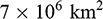 with a volume estimate of
 (Reference LancasterLancaster, 2022). The greatest concentrations of desert sand seas and dune fields occur at midlatitudes (
 ), especially in the arid regions of central Asia and China, and in low-latitude desert areas of Africa, Arabia, and Australia (
 ) (Fig. 1.1).
Figure 1.1 Global map of sand seas and dune fields.
1.1 Dunes as Complex Systems
Desert sand dunes form part of self-organized complex systems of aeolian bedforms, which comprise a hierarchy of (1) wind ripples, (2) individual simple dunes or superimposed dunes on mega dunes, (3) megadunes (also called draa or compound and complex dunes) – characterized by superimposition of simple or elemental dunes on larger forms, and (4) dune fields and sand seas (Fig. 1.2). The self-organized patterns of dunes develop over time and in space as the nonlinear response of sand surfaces to the wind regime (especially its directional variability) and the supply of sand (Reference Kocurek and EwingKocurek and Ewing, 2005; Reference WernerWerner, 1995). As the spatial scale increases, the number of variables decreases, and smaller-scale processes (e.g. the saltation of sand grains) are subordinated to and decoupled from emergent, larger-scale behavior, such as interactions between dunes. This reduction of variables with increasing scale facilitates understanding of key aspects of dune-field patterns, such as dune spacing and dune reorientation with changes in wind regime (Reference Kocurek and EwingKocurek and Ewing, 2005) as well as the assessment of responses to external changes on differing spatial and temporal scales. It also provides a framework in which to transfer knowledge of dune systems on Earth to other planetary bodies, such as Mars and Saturn’s moon Titan (Reference Ewing, McDonald and HayesEwing et al., 2015b).

Figure 1.2 Temporal and spatial scales of dune systems.
1.2 Dune Systems
Sand seas and dune fields are dynamic sedimentary bodies that form part of local to regional-scale sand transport systems in which sand is moved by the wind from source zones to depositional sinks via transport pathways (Fig. 1.3). Dune formation is therefore dependent on a supply of sand-sized sediment, wind energy to entrain and transport that material, and topographic and/or climatic conditions that promote deposition of that sediment. Sources and sinks for sediment are linked by a cascade of energy and materials that can be viewed in terms of sediment inputs and outputs, transfers, and storages that determine the sediment state of the system.

Figure 1.3 Example of a sand transport system – Kelso Dunes, California. Sand is transported west to east from the Mojave River fan-delta to the dunes. Alluvial fans adjacent to the dunes provide secondary sand sources.
Following Reference Kocurek, Chan and ArcherKocurek and Havholm (1993) dune systems (Fig. 1.4) can be divided into (1) dry systems, in which the water table and its capillary fringe are sufficiently far below the depositional surface that they have no effect on dune migration, sediment transport, and deposition; (2) wet systems, where the water table and its capillary fringe is at or near the depositional surface. Dune dynamics and sediment transport and deposition are controlled both by the wind regime and by the moisture content of the substrate; and (3) stabilized systems, in which vegetation or some other factor periodically or continually stabilizes the substrate while the system remains active overall. Good examples of dry aeolian systems are the majority of the Namib Sand Sea and the Algodones Dunefield (California). Wet aeolian systems include the coastal parts of the Namib Sand Sea, White Sands dune field (New Mexico, USA), as well as the Liwa and adjacent areas of the Rub’ al Khali in the United Arab Emirates and adjacent areas of Saudi Arabia. Stabilized systems include the Thar Desert sand sea in India, much of the southwestern Kalahari and Australia, and parts of the Negev–Sinai sand sea (Egypt and Israel). These designations can change over time, as water tables rise and fall and vegetation expands and contracts in relation to climate and sea level change; they can also vary spatially – parts of a sand sea may behave as a wet or stabilized system, while other areas are dry. Thus, many eastern parts of the Namib Sand Sea represent a stabilized dune system; coastal areas of the same sand sea near Walvis Bay are a wet system; the majority is a dry system.

Figure 1.4 Characteristics of aeolian systems in relation to water tables and stabilization by vegetation.
1.3 The Concept of Sediment State
The concept of sediment state as articulated by Reference Lancaster, Goudie, Livingstone and StokesKocurek and Lancaster (1999) provides a framework in which to assess the state of dune systems and their response to changes in external forcing (e.g. climate change) as well as the internal dynamics of the system. In this model, development of dune systems is governed by the supply of sediment of a size suitable for transport by the wind, the existence of wind energy to erode and transport this material (erosivity or mobility), and the susceptibility of the surface to entrainment of material by wind (erodibility or sediment availability). The interactions between these variables in space and time determine the overall state of the aeolian system, which may be supply limited, availability limited, or mobility limited (Reference Lancaster, Goudie, Livingstone and StokesKocurek and Lancaster, 1999). In this conceptual model, sediment supply is defined as the emplacement of sediment of a size suitable for wind transport that serves as a source of material for the system. Sediment availability is the susceptibility of a sediment surface to entrainment of material by wind, as determined by factors such as vegetation cover and soil moisture content. Sediment mobility (or potential transport rate) is determined by the magnitude and frequency of winds capable of transporting sediment. The actual sand transport rate (Qa) is determined by sediment supply and availability and may be less than the potential rate (Qp) in proportion to the ratio Qa/Qp,
The relations between sediment supply, availability, and mobility define the state of the sand transport system and its variation through time (Fig. 1.5), including its response to external forcing factors such as climate change.

Figure 1.5 Matrix of possible states of a sand transport system.
The overall state of the system may be described as follows:
(1) Supply limited, in which
 and the system is starved of sediment, as in many central and northern sand Saharan sand seas, some of which are apparently eroding in present conditions (Reference Mainguet and El-BazMainguet, 1984). Variations in sediment supply (e.g. as a result of sea level changes, and changes in river sediment loads) appear to be most important where dunes are close to their source, as in the Mojave desert (Reference Lancaster, Tchakerian, Enzel, Wells and LancasterLancaster and Tchakerian, 2003), the Takla Makan, and in some parts of Arabia (Reference Garzanti, Vermeesch and AndòGarzanti et al., 2013; Reference Rittner, Vermeesch and CarterRittner et al., 2016).
(2) Availability limited, in which
. In many areas, for example, southwestern Kalahari, Great Plains of the USA, northeastern China, and Australia, sediment availability is determined by vegetation cover. Changes in sediment availability as a result of variations in rainfall and vegetation cover have played a dominant role in episodic development of dunes in the southwestern Kalahari and Australia (Reference Telfer and HesseTelfer and Hesse, 2013; Reference Telfer and ThomasTelfer and Thomas, 2007), in addition to determining periods of dune activity in many semiarid regions, such as the High Plains of North America (Reference Halfen and JohnsonHalfen and Johnson, 2013) and northeastern China (Reference Lu, Miao and ZhouLu et al., 2005; Reference Yang, Scuderi and PaillouYang et al., 2011).(3) Transport limited, in which the actual rate of sand transport (Qa) equals the potential rate (Qp) and the system is limited only by the capacity of the wind to move sediment from source zones, for example, the Namib Sand Sea (Reference LancasterLancaster, 1989b).


The variations over time in sediment supply, availability, and mobility (transport capacity) can be used to evaluate the long-term dynamics of a dune system as a function of its sediment state (Fig. 1.6). Sediment supply can provide contemporaneous input to the system (CI) or be stored (S), if it is limited by availability (e.g. vegetation, high water table) and/or the transport capacity of the wind (e.g. low wind energy). Stored sediment can released later to provide lagged input (LI), if availability and/or transport capacity increase. In time, the supply of sediment may be exhausted, in which case the system becomes supply-limited. If availability remains high, then
 and the system will become net erosional.

(a) aeolian construction contemporaneous with the generation of the sediment supply;

(b) aeolian construction separated in time from an earlier period when the sediment supply was generated;

(c) aeolian construction sourced by both a contemporaneous sediment supply and erosion of previously stored sediment.
Figure 1.6 Variation of sediment state through time shown through trends in sediment supply, availability, and mobility:
1.4 The Quaternary Legacy
Sand seas and many dune fields contain large volumes of sand, implying that their accumulation has taken place over many thousands or tens of thousands of years, during which Quaternary climatic and sea level changes have had a significant impact on sediment supply, availability, and mobility. Analysis of patterns of dune morphology and morphometry, as well as stratigraphic and dating studies of dune sediments in many areas indicates the importance of the legacy of Quaternary periods of dune construction, stability, and reworking (Reference Thomas and BaileyThomas and Bailey, 2017; Reference Thomas and BaileyThomas and Bailey, 2019). The Quaternary legacy varies in importance from apparently minor in young, rapidly developing dune fields, for example, Skeleton Coast dune fields of Namibia; to dominant, as in the vegetation-stabilized dune fields of the Kalahari, the Great Plains of North America, and Australia.
In addition, there are many examples of dune systems that are currently inactive and stabilized by vegetation and biocrusts. Such systems are common on the margins of active desert dune areas and in semiarid regions. They are indicative of past environments in which dune formation was promoted by changes in sediment supply, availability, and mobility. These paleo-dune systems have been demonstrated to be a product of Quaternary climatic changes .
1.5 Development of Modern Dune Studies
Modern dune studies aim to understand dune morphology and development in the context of changing boundary conditions of sediment supply, availability, and mobility. The paradigms that guide dune studies today are the product of decades of observations and experiments, aided by developments in technology and cross-fertilization from other areas of geomorphology and geology, physics, and ecology (Reference Livingstone, Wiggs and WeaverLivingstone et al., 2007; Reference Thomas and WiggsThomas and Wiggs, 2008).
Desert dunes have been the object of study for many years (see summary in Reference Goudie, Goudie, Livingstone and StokesGoudie [1999]). Early scientific descriptions of sand seas resulted from exploration of desert regions and assessment of their natural resources (Reference BagnoldBagnold, 1951; Reference Capot-ReyCapot-Rey, 1947; Reference HackHack, 1941; Reference MadiganMadigan, 1936). Widespread availability of aerial photographs in the 1950s and 1960s provided a broader perspective (Reference HolmHolm, 1960; Reference SmithSmith, 1965; Reference TwidaleTwidale, 1972) including recognition of relict sand seas in desert margin areas (Reference GroveGrove, 1958; Reference Grove and WarrenGrove and Warren, 1968) and provided data for some significant conceptual advances by Ian Wilson (Reference WilsonWilson, 1971, Reference Wilson1972, Reference Wilson1973). Satellite images first became available in 1972 and have revolutionized studies of sand seas, first providing a synoptic global view (Reference McKee and McKeeMcKee, 1979), in which it was recognized that similar dune types occur in widely separated sand seas, enabling correlation of dune types with wind regimes (Reference Fryberger and McKeeFryberger and Dean, 1979; Reference Wasson and HydeWasson and Hyde, 1983a) and mapping of dune types (Reference Breed, Fryberger, Andrews and McKeeBreed et al., 1979). The spectral information in a variety of remote sensing platforms has enabled analysis of the distribution of different sand populations and tracing of sand sources, using visible near infrared (VNIR) (Reference Blount, Smith, Adams, Greeley and ChristensenBlount et al., 1990; Reference White, Goudie, Parker and Al-FarrajWhite et al., 2001; Reference White, Walden and GurneyWhite et al., 2007) and thermal infrared (TIR) wavelength regions (Reference Ramsey, Christensen, Lancaster and HowardRamsey et al., 1999; Reference Scheidt, Lancaster and RamseyScheidt et al., 2011). In addition, digital elevation models derived from satellite and aircraft systems are providing valuable data sets for analysis of patterns of dune morphology and distribution (Reference Al-Masrahy and MountneyAl-Masrahy and Mountney, 2013; Reference BishopBishop, 2013; Reference Hugenholtz, Levin, Barchyn and BaddockHugenholtz et al., 2012). Remote sensing analyses of dune sand composition are complemented by increasingly precise mineralogical, geochemical, and isotopic analyses that provide insights into sand sources and transport pathways (e.g. Reference MuhsMuhs, 2004; Reference MuhsMuhs, 2017; Reference Muhs and BudahnMuhs and Budahn, 2019; Reference Muhs, Lancaster and SkippMuhs et al., 2017).
The advent of luminescence dating in the 1980s (Reference Singhvi, Sharma and AgrawalSinghvi et al., 1982) and its wider application in the 1990s (Reference StokesStokes, 1992) have revolutionized knowledge of the chronology of periods of dune construction and reworking in many sand seas (Reference Lancaster, Wolfe and ThomasLancaster et al., 2016), although many issues of interpretation of the ages remain (e.g. Reference Thomas and BaileyThomas and Bailey, 2017).
A major development in dune studies has been the development of numerical modeling of dunes, facilitated by vastly increased computing power. The formation and evolution of elementary dunes as well as entire dune fields and dune interactions are now simulated with high spatiotemporal resolution with reduced-complexity models such as cellular automata (e.g. Reference Bishop, Momiji, Carretero-Gonzalez and WarrenBishop et al., 2002; Reference Narteau, Zhang, Rozier and ClaudinNarteau et al., 2009; Reference Nishimori, Yamasaki and AndersenNishimori et al., 1998; Reference WernerWerner, 1995) as well as with physically based coupled airflow-sand transport models (e.g. Reference Andreotti, Claudin and DouadyAndreotti et al., 2002b; Reference Hersen, Anderson and ElbelrhitiHersen et al., 2004; Reference Parteli, Kroy, Tsoar, Andrade and PöschelParteli et al., 2014; Reference Schwämmle and HerrmannSchwämmle and Herrmann, 2004). This has led to significant conceptual advances in our understanding of how dunes and dune patterns develop, including their responses to different wind regimes (Reference Courrech du Pont, Narteau and GaoCourrech du Pont et al., 2014; Reference Eastwood, Nield, Baas and KocurekEastwood et al., 2011; Reference Gao, Narteau, Rozier and Courrech du PontGao et al., 2015b; Reference Reffet, Courrech du Pont, Hersen and DouadyReffet et al., 2010) and to climate change via changes in vegetation cover (Reference Nield and BaasNield and Baas, 2008a).


