


INTRODUCTION
Fortification at a monumental scale offers great potential for insight into the archaeological study of warfare, due both to its frequent perseverance through time and the spatialized implications of its constructed form. A sense of the scale, prevalence, and practice of conflict that spurred its construction can be deduced from these spatialized implications by assessing the nature of the space being protected, its relation to adjacent settlement, the hastiness of the construction project, and the form and scale of attack the fortification was intended to repel. Furthermore, ongoing maintenance and defensive use of the features speaks to continued or renewed uncertainty in the region, with occupants of the site perceiving an advantage in sustained investment in fortification.
The nature of warfare in the Maya world has become increasingly well understood in recent decades. Archaeological evidence in the form of weaponry, bioarchaeological analysis, and fortification, along with other settlement data, has worked alongside ethnographic writings to provide insight into Postclassic (a.d. 1000–1525) and Contact period (a.d. 1525–1697) warfare. In the Classic period (a.d. 250–1000), glyphic description and artistic depiction have supplemented the archaeological evidence to produce a detailed picture of political conquest, captive taking and sacrifice (Earley Reference Earley2023), and weapons, armor, and other attire (Miller Reference Miller2023). Far less detail has been established, however, regarding these matters in the preceding Preclassic period.
A recent explosion of archaeological research into the Maya Preclassic (2000 b.c. to a.d. 250) has substantiated notions of widespread sociopolitical complexity during that time, with the origin of states occurring in the Middle Preclassic (1000–400 b.c.) and the ensuing Late Preclassic (400 b.c. to a.d. 150) as a time of dramatic expansion and spread of state-level civilization (Freidel et al. Reference Freidel, Chase, Dowd and Murdock2017; Traxler and Sharer Reference Traxler and Sharer2016). The earliest known Maya fortifications date to the Late Preclassic, typically at large sites such as those in the Mirador Basin (Acuña and Chiriboga Reference Acuña and Chiriboga2019; Hansen Reference Hansen, Traxler and Sharer2016:400) and at Cival (Estrada-Belli Reference Estrada-Belli2011:131–132). At the small site of Muralla de León (Figure 1), however, located on the shoreline of Lake Macanche in the Peten Lakes Region of northern Guatemala and the primary focus of this paper, a monumental stone wall surrounding the site was determined by recent investigation to have been constructed in the first two centuries of the Late Preclassic period.
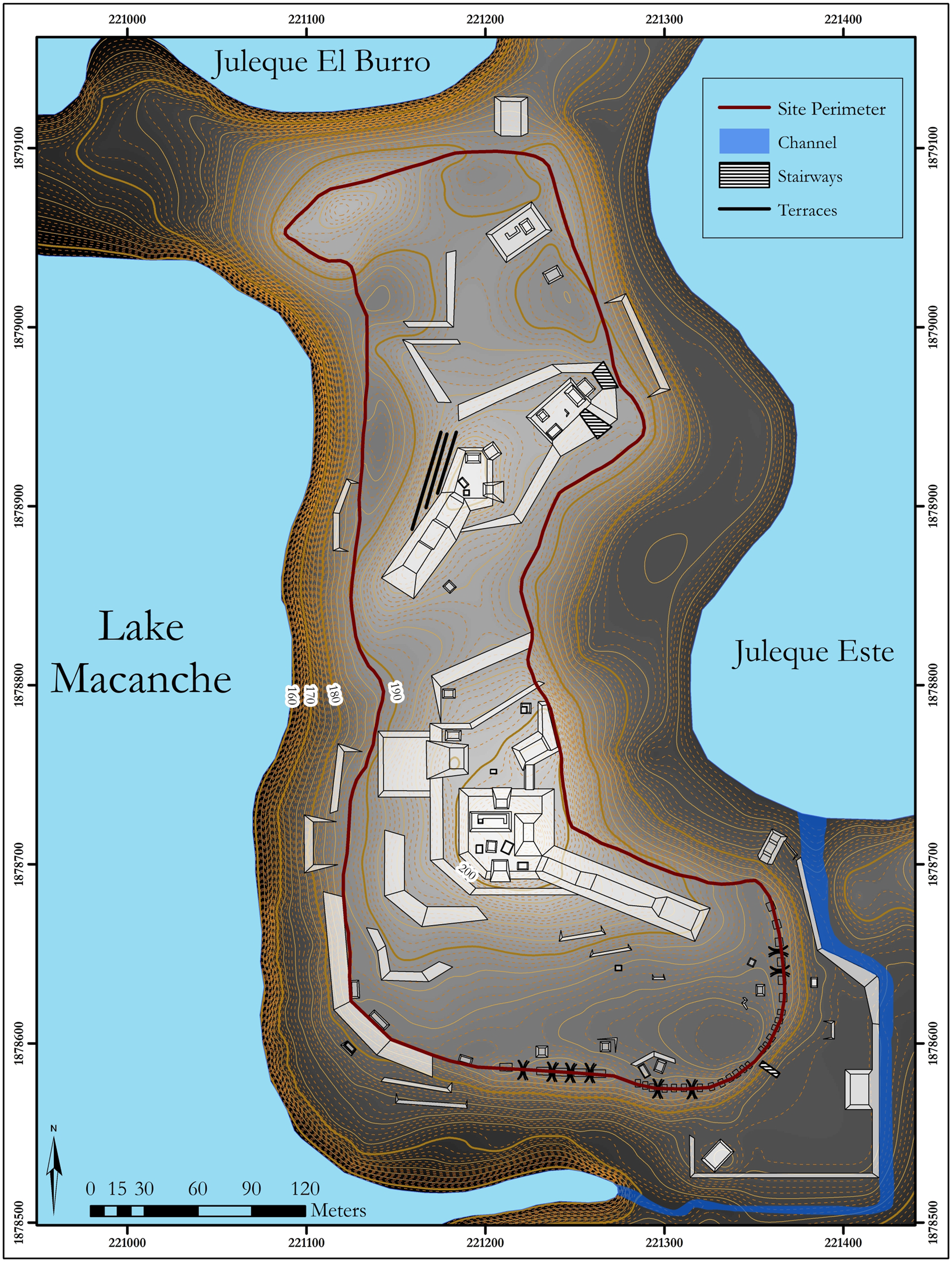
Figure 1. Muralla de León site map. Map by the author.
The guiding research question of this paper can be stated as follows: Was warfare an explicit factor in the process by which sociopolitical complexity developed and spread beyond the major population centers in the Maya lowlands? This question is addressed through analysis of the encircling stone wall, or enceinte, at Muralla de León, an apparent fortification extending 1.5 km in circumference and rising over 5.5 meters high in places surrounding a site that rests atop a naturally defensive landform. The constructed wall and natural rise together present a steep approach to the occupied upper portion of the site, in places an 18 m vertical ascent.
A first line of investigation seeks to establish that the perimeter wall was functionally defensive in its Preclassic form. Secondly, a separate assessment investigates whether the site's location was strategic within the likely paths of movement across the region in the Late Preclassic period. If both hypotheses are supported, it would indicate that defensibility against attacks at population centers was a prominent concern among those coordinating the design and execution of site-wide layouts. Furthermore, the material presence of actively maintained, identifiable fortifications across the era in which sociopolitical complexity was established in the region would imply that warfare was a factor in that process. In such a case, the fortifications are an explicit indicator of and reference to warfare, visible to residents and visitors alike in the Macanche basin and physically interacted with by anyone traversing the area around Muralla de León. Their delineation of space and effective protection against attack, along with symbolic projections of strength, authority, and surveillance of the basin, would have unavoidably injected warfare as a consideration in the many levels of negotiation that led to the establishment of sociopolitical complexity in the region.
The insights offered by the study of fortification into the practice of Preclassic Maya warfare and its role in the geopolitical dynamics of the time are considered in the section Discussion below. The setting of the Middle through Terminal Preclassic is first established, followed by an overview of the current state of research into Maya fortification and its relationship to practices of warfare. The site of Muralla de León is then described, and the fieldwork and subsequent geographic information systems (GIS) analyses of affordances of movement in relation to the variable perimeter wall construction are presented. These analyses bring new insight and resolution to the Late Preclassic networks of movement and exchange that defined the regional interaction sphere of the time. In this way, the study contributes to understanding of Mesoamerican warfare and its developmental role in the emergence of Maya complexity and institutions through detailed examination of the relationship between the natural landscape, built environment, and the particular needs of the builders, occupants, and other dwellers of a space.
MIDDLE, LATE, AND TERMINAL PRECLASSIC DYNAMICS
The Maya Preclassic, once thought to be mostly devoid of widespread settlement nucleation and monumental-scale architecture, is now understood to have been the setting for the first major wave of state-level development across the region. Work at El Mirador in the 1980s and 1990s (Fowler et al. Reference Fowler, Demarest, Michel, Asaro and Stross1989; Hansen Reference Hansen1990) that established the site's extent and Late Preclassic provenience has more recently been complemented by data from an array of sites indicating complex sociopolitical activity going back to the early facet of the Middle Preclassic period, from 1000–700 b.c. (Hansen Reference Hansen, Traxler and Sharer2016). A standardized pattern of ritual complexes was in place by this time, including at Ceibal (Inomata et al. Reference Inomata, Triadan, Aoyama, Castillo and Yonenobu2013), predating the establishment of the Olmec site of La Venta as a significant center and thus removing the possibility that the traits were adopted from the Olmec. The earliest ceremonial architecture at Ceibal dates to about 950 b.c., roughly contemporaneous with the introduction of ceramics in the region (Inomata et al. Reference Inomata, MacLellan, Triadan, Munson, Burham, Aoyama, Nasu, Pinzón and Yonenobu2015a, Reference Inomata, MacLellan and Burham2015b).
The distribution of the various early Middle Preclassic ceramic complexes that have been identified offers insight into the patterns of trade and other movement of people and goods across networks that can be captured by the concept of the interaction sphere (Caldwell Reference Caldwell1964; Freidel Reference Freidel1979). The Cunil, Xe, and Eb ceramic complexes of the early Middle Preclassic correspond to the coastal river valleys of Belize, the drainages of the Pasión, San Pedro Martír, and Usumacinta Rivers, and the central lowlands, respectively (Castellanos and Foias Reference Castellanos and Foias2017). Architectural patterns are also indicative of regional interaction, especially the E-Group, the hallmark arrangement of the era (Freidel et al. Reference Freidel, Chase, Dowd and Murdock2017). The unique regional developments occurring in parallel within each of these interaction spheres established cultural traits and practices that would shape the more interconnected (and perhaps more homogenized) Classic-period Maya society.
The Eb ceramic complex that characterized the early Middle Preclassic of the central lowlands interaction sphere was found throughout the Peten Lakes Region, indicating strong connections at the time between the residents around the Lakes and major sites to the north including Tikal, Uaxactun, and those within the Mirador Basin. Cunil ceramics, however, appear alongside the Eb examples in the Yaxha-Sacnab basin (Clark and Cheetham Reference Clark, Cheetham and Parkinson2002). While such a dynamic makes sense due to the proximity of the basin to Belize, it is also indicative of an overlap of influences not seen in the other parts of the Peten Lakes Region to the west and suggests that the basin functioned as a borderland between these zones. As discussed below in section Central Peten Dynamics in the Late Preclassic, this fact, in conjunction with the overland gap of over 20 kilometers between Lakes Yaxha and Macanche, suggests that a tighter-knit central cluster of the Peten Lakes Region existed exclusive of Lakes Yaxha and Sacnab. In this formulation, Lake Macanche is the eastern boundary of the central cluster and Muralla de León the entrance point for an approach from the east (Figure 2).
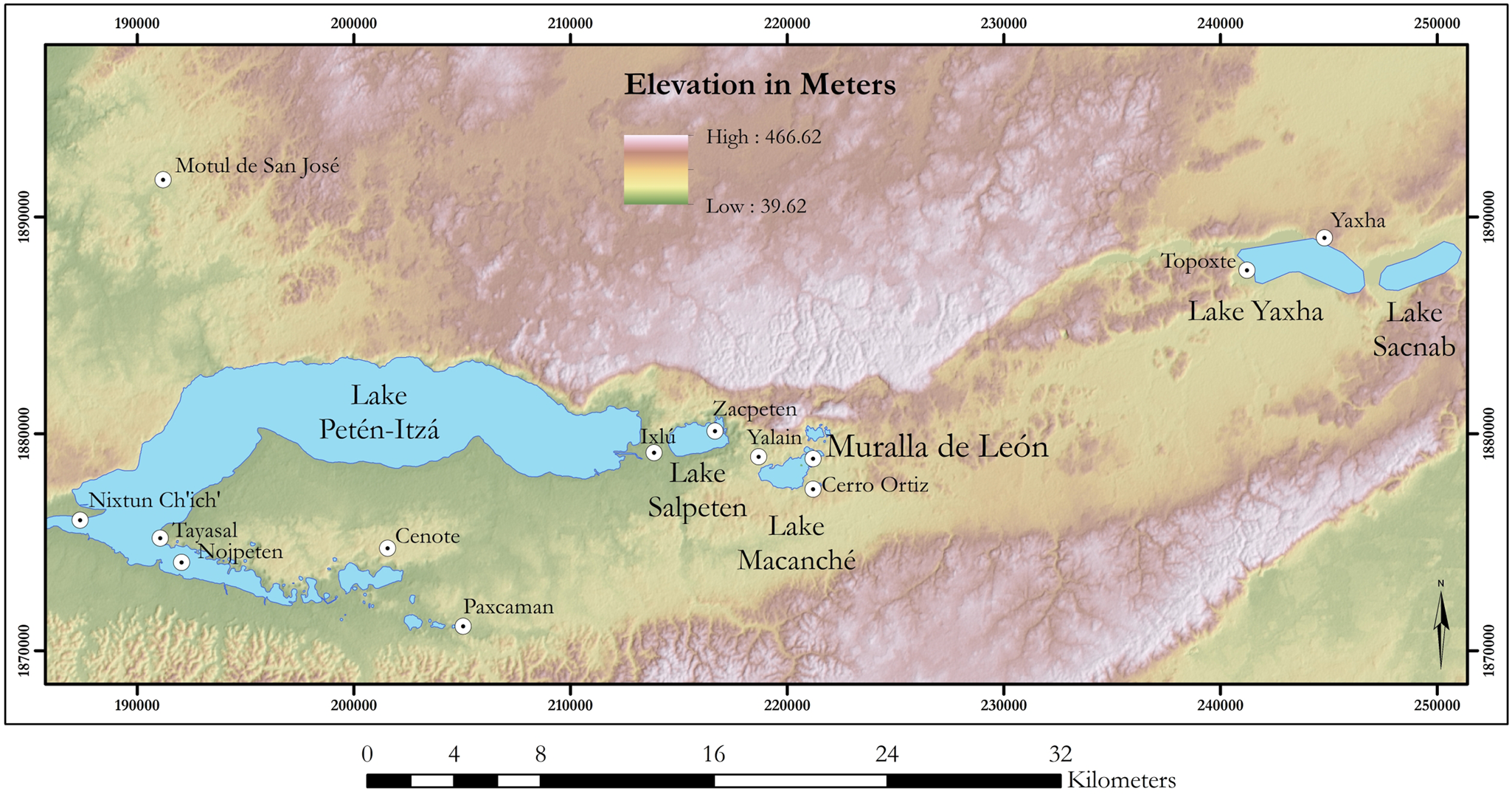
Figure 2. The Peten Lakes Region, showing major sites and the overland gap between Lake Macanche and Lake Yaxha. Map by the author.
In addition to Ceibal, other monumental Middle Preclassic developments are seen in the Peten across the Mirador Basin and at the site of Nixtun-Ch'ich’, located in the Peten Lakes area, as well as in the Middle Usumacinta region of Tabasco, Mexico, at Aguada Fénix and La Carmelita. All these sites contain at least one E-Group complex. A cluster of sites in the Mirador Basin, including Nakbe, El Mirador, Wakna, and Xulnal, indicate occupation dating back to the early Middle Preclassic (Hansen Reference Hansen, Traxler and Sharer2016:343). Recent work at Nixtun-Ch'ich’, situated along a peninsula on the shore of Lake Peten-Itza, has established that it was laid out on a large-scale, regular grid system of streets and avenues at this same time (Pugh and Rice Reference Pugh and Rice2017; Rice and Pugh Reference Rice and Pugh2017; Rice et al. Reference Rice, Pugh and Chan Nieto2019). More recently, aerial light detection and ranging (LiDAR) scanning has delineated the massive platform of Aguada Fénix, with follow-up excavation establishing its early Middle Preclassic construction date and a constructed volume larger than the La Danta complex at El Mirador (Inomata et al. Reference Inomata, Triadan, Vázquez López, Fernandez-Diaz, Omori, Méndez Bauer, Hernández, Beach, Cagnato and Aoyama2020).
The Late Preclassic period witnessed the broadening of sociopolitical complexity, with nucleated, monumental sites occurring more frequently across the Maya lowlands and the Triadic Group as its architectural hallmark (Hansen Reference Hansen1990; Szymański Reference Szymański2014). Trade flowed over land and water through sites like Cerros, while El Mirador, the largest site of the time, served as the central node of the Central Peten interaction sphere (Reese-Taylor and Walker Reference Reese-Taylor, Walker, Masson and Freidel2002). Meanwhile, Tikal and likely other sites established hereditary royal dynasties during this period (Martin and Grube Reference Martin and Grube2000). The time period of interest in this paper is the first two centuries of the Late Preclassic, during which the Middle Preclassic regional dynamics described above began to shift and accelerate to set up the great flourishing of the latter centuries of the Late Preclassic. As the period started drawing to a close, El Mirador began fading rapidly, and other regions such as the Petexbatun showed signs of turmoil as well (Inomata et al. Reference Inomata, Triadan, MacLellan, Burham, Aoyama, Palomo, Yonenobu, Pinzón and Nasu2017). The Terminal Preclassic (a.d. 150–250) marks the first Maya collapse, as the regional networks of interaction fell apart and sites across the central lowlands were depopulated (Dunning et al. Reference Dunning, Beach and Luzzadder-Beach2012; Estrada-Belli Reference Estrada-Belli, Traxler and Sharer2016; Hansen Reference Hansen, Traxler and Sharer2016; Inomata et al. Reference Inomata, Triadan, MacLellan, Burham, Aoyama, Palomo, Yonenobu, Pinzón and Nasu2017).
The rise and fall that can be traced in an arc across the Middle, Late, and Terminal Preclassic periods was not nearly as smooth as the narrative above implies, with its zoomed-out perspective capturing more than a millennium of activity. Fluctuating patterns of coalescence and dissolution of polities and alliances would have characterized the trajectory, only slowly over the course of numerous generations apparent as a positive trend toward increased consolidation and greater complexity. This framing is akin to the Dynamic Model as described by Marcus (Reference Marcus, Sabloff and Henderson1993, Reference Marcus, Feinman and Marcus1998). A closer look at the interactions that drove these processes forward highlights war and trade as “twin strategies” (Stanish and Levine Reference Stanish and Levine2011:13901) implicated in the trend toward increased sociopolitical complexity.
FORTIFICATION AND MONUMENTALITY
In their super-domestic scale, imposing nature, and the coordination and labor budget required to build them, fortifications can often be classified as monumental (Osborne Reference Osborne and Osborne2014; Rosenswig and Burger Reference Rosenswig, Burger, Burger and Rosenswig2012). The intent of fortification in many cases is perceptual, projecting impenetrability and strength to dissuade attack upon them (Trigger Reference Trigger1990:121–122). Inherently, as well, the transformation of the landscape in constructing fortifications reshapes paths of movement, both in times of peace and of conflict. These realignments of movement are often the direct purpose of the construction effort, and its effectiveness in keeping hostile forces out of the space needs to be tempered by the inclusion of gates and other allowances for quotidian passage when no threat is present (Keeley et al. Reference Keeley, Fontana and Quick2007:71).
Fortifications that protect settlements create unambiguous demarcations on the ground, establishing a clear interior and exterior that would have promoted a common identity among those permitted to use the space. Their visibility and legibility formed a widely visible and recognizable symbol of the site as a whole (Lynch Reference Lynch1960; Pepper Reference Pepper and Tracy2000; Tracy Reference Tracy2000). In this sense, they convey messages to those interacting with them that speak to the manipulation and symbolic appropriation of the natural landscape as well as authority and the delineation of controlled space. They additionally signal the polity's success in organizing resources and labor to a successfully completed project (DeMarrais et al. Reference DeMarrais, Castillo and Earle1996:18–19), a crucial element of placemaking, or “the making and marking of socially significant places in the landscape through monuments” (Glatz Reference Glatz and Osborne2014:109), among early complex polities (Mann Reference Mann1984). The typical longevity of constructed fortifications, a result of the stone often used to construct them and the advantages of durability in the face of sustained attack, mean that they frequently remain in some form for observation and analysis by later generations, including archaeologists. Thus, they can offer insight into the concerns of the architects and builders, and of the local populace more broadly.
Maya Fortifications
The body of known fortified Maya sites, already expanding in recent decades based on traditional survey and mapping (Cortes Rincon Reference Cortes Rincon2007), has grown rapidly over the past decade (Acuña and Chiriboga Reference Acuña and Chiriboga2019; Estrada-Belli Reference Estrada-Belli, Traxler and Sharer2016; Hansen Reference Hansen, Chacon and Mendoza2017; Scherer et al. Reference Scherer, Golden, Firpi, Schroder, Urquizú and Román2019), offering more detailed insight into the nature of Maya warfare through time. The increasingly common use of LiDAR scanning promises to sustain this discovery rate for at least a few years more. In analyzing the practice of Maya warfare, texts, murals, and carved stone depictions from the Early Classic onward provide independent lines of evidence that complement the material record; in the preceding Preclassic, however, such comparative evidence is lacking. The material record from this earlier era—the fortifications and other settlement evidence, weapons, and bioarchaeological evidence, as well as regional contextual data—is thus at the forefront of understanding the significance of warfare to Preclassic Maya societies. Such a determination speaks directly to the role of warfare in the establishment and maintenance of sociopolitical complexity in the region. Known examples of Maya fortification are provided below in reverse chronological order.
Ethnographic accounts from Europeans in the sixteenth century provide the first accounts of fortifications in the Maya world. Cortés (Reference Cortés2001 [1525]) describes a town, likely to the northwest of Lake Peten-Itza, set on a “high rock” with a lake to one side and a deep stream to the other, with the entire town encircled by a deep moat backed by a wooden palisade. He goes on to mention other similar fortifications, as do other Contact-era sources, with wooden palisades bearing frequent mention and stone walls, often planted with thorny brush, also incorporated into these defensive systems (Gutiérrez Reference Gutiérrez2005; Palka Reference Palka2001:428). Examples from Mayapan (Russell Reference Russell2013), as well as Tulum, Xelha, and Ichpaatun (Webster Reference Webster1976b:365) in the northern Yucatan occur in the Postclassic, and Yaxuna was fortified in the Terminal Classic following three earlier conflict events at the site (Ambrosino et al. Reference Ambrosino, Ardren, Stanton, Brown and Stanton2003).
Classic-period examples include Cuca, Chacchob, and Dzonot Ake in the north (Webster Reference Webster1979), as well as Muna and the larger center of Chunchucmil (Dahlin Reference Dahlin2000). Petexbatun fortification was mostly associated with turmoil at the end of the Late Classic at sites like Dos Pilas (Demarest et al. Reference Demarest, O'Mansky, Wolley, Van Tuerenhout, Inomata, Palka and Escobedo1997) and Punta de Chimino (Inomata Reference Inomata2008), though some, such as the latter, could have had earlier origins in the Late Preclassic (Inomata Reference Inomata, Scherer and Verano2014:45; Webster Reference Webster2000:74). Strategic hilltop centers are documented along the border of regional control between Yaxchilan and Piedras Negras on the Usumacinta River, suggesting boundary maintenance and regular actual or attempted incursions from either side (Golden and Scherer Reference Golden and Scherer2006; Golden et al. Reference Golden, Muñoz, Escobedo, Houston, Kovak, Laporte, Arroyo, Escobedo and Mejia2003). The extensive Tikal earthwork, a ditch and embankment extending 13.6 km in discontinuous fashion along the site's northern hinterland, was initially categorized as defensive (Puleston and Callender Reference Puleston and Callender1967), an interpretation that has been called into question by more recent work that promotes a hydraulic function for the feature (Silverstein et al. Reference Silverstein, Webster, Martinez and Soto2009; Webster et al. Reference Webster, Murtha, Straight, Silverstein, Martinez, Terry and Burnett2007). A few sites demonstrate clear evidence for the construction of monumental fortifications in the Early Classic period. Well known since Webster's work there in the 1970s, Becan's enceinte and associated moat and causeways were constructed at the time, establishing the prevalence of warfare by then (Webster Reference Webster1976a). Recent LiDAR mapping has revealed two sites, La Cuernavilla and Pucte, near El Palmar to the west of Tikal, that are strongly fortified (Garrison et al. Reference Garrison, Houston and Firpi2019).
Fewer examples of Preclassic fortification have been located, though recent work has added to the list substantially. Cerros (Scarborough Reference Scarborough1983:736) and Edzná (Matheny et al. Reference Matheny, Forsyth, Gurr and Hauck1983:78) each contain canal systems that functioned, at least in part, as defensive moats. In the Mirador Basin of the northern Peten, work at Xulnal and Tintal has uncovered additional Late Preclassic moat systems, and at El Mirador a large wall-and-moat fortification (Acuña and Chiriboga Reference Acuña and Chiriboga2019; Hansen Reference Hansen, Traxler and Sharer2016:400). Perhaps most intriguing, Cival in northeast Peten has produced evidence for a Late Preclassic encircling stone wall topped with a wooden palisade around its ceremonial core (Estrada-Belli Reference Estrada-Belli2011:131–132). The construction appears hasty, as the fortifications cut across the central precinct and the site was apparently overrun shortly after they were built.
Deducing Practice from Fortifications
The nature of Maya warfare, as deduced from fortifications and other available evidence, continues to be debated (Graham Reference Graham, Morton and Peuramaki-Brown2019). Warfare is considered here as organized interpolity violence between two or more groups. Raiding, discussed further below, is a form of warfare, while violence is a broader category, defined by James (Reference James and Ralph2012:98–99) as “the use of physical force with intent to inflict injury on people, or damage to their physical property or resources.” Violence outside of the realm of warfare can include domestic conflict between spouses or other relatives, or between unrelated individuals or groups within a society. It is also inflicted upon the populace by the state, which, as noted by Weber (Reference Weber2014 [1919]) in his speech “Politics as Vocation,” has a monopoly on its legitimized use (Waters Reference Waters2015:136). The term “conflict” is used as a general term encompassing all these uses.
For the Maya, glyphic inscriptions have long provided a textual record of interpolity conflict, and murals like those at Bonampak provide direct representation (Miller Reference Miller1986; Rands Reference Rands1952; Schele and Miller Reference Schele and Miller1986). Differing opinions persist, however, as to how literally to interpret these records, and the extent to which the practice of warfare pervaded Maya society. Thought by some to have been limited to a ritualized elite activity constrained by numerous regulations (e.g., Schele and Mathews Reference Schele, Mathews and Culbert1991), the presence of fortifications at site centers indicates warfare as a more widespread activity. These debates double back to a question raised by Demarest (Reference Demarest, Giardino, Edmonson and Creamer1978) regarding internal versus external warfare. Internal warfare describes conflict between opponents who regard themselves as similar, likely sharing a language, cultural attributes, and (most importantly) a code of conduct for battle. These common elements can serve as limiting factors on the thoroughness of conquest, moving the arena of battle away from settlements to neutral grounds and sparing non-participants such as women and children. External warfare, as the opposite, describes conflict between more dissimilar combatants who have no reason to trust their enemy to hold back from any opportunity afforded them. The engagement is thus brought to settlements themselves, and in the most extreme form spare neither domestic spaces nor non-participants from violence akin to the “total warfare” of Wahl et al. (Reference Wahl, Anderson, Estrada-Belli and Tokovinine2019).
Examples from the Maya world indicate that both external and internal conflict occurred throughout the long history of the area. The controlled, “ritualized” context (see Kim et al. [Reference Kim, Hernandez, Bracken and Seligson2023] for a discussion of the category of “ritual warfare”) for conflict among Late Classic polities as depicted and described on carved stelae suggests an internal warfare limited to elites and circumscribed by a bevy of formal constraints, with killing limited to the later sacrifice of captured warriors and leaders (Freidel Reference Freidel, Renfrew and Cherry1986). While such practice undoubtedly occurred, it is unclear how prevalent it was relative to other modes of conflict, and the degree to which we should rely on these depictions as historical fact (see Earley Reference Earley2023). Less constrained, likely external (and closer to what could be called “total”) warfare, also existed during this time, as seen in the fortification and subsequent abandonment of major sites in the Petexbatun. The palisades at Dos Pilas, hastily constructed atop low base walls around a.d. 760, cut across existing structures and appear to have been erected in the face of imminent danger, against which they failed (Demarest et al. Reference Demarest, O'Mansky, Wolley, Van Tuerenhout, Inomata, Palka and Escobedo1997:232–235). Likewise, nearby Aguateca was fortified in the Late Classic. Though the walls were built more deliberately, maintaining the established spatial layout of the site and protecting a sizable population, they too were unable to keep danger at bay, and the site was destroyed sometime around a.d. 800 (Inomata Reference Inomata1997).
The absence of texts, carved stone monuments, and mural art related to conflict from the Preclassic means that fortification currently provides the foremost line of evidence for the role of Maya warfare in the social dynamics of the era. The examples given above demonstrate a diversity of forms, from improvised and desperate to methodical and integrated with a comprehensive site plan. Instances of the latter are frequently engineered in conjunction with functional hydraulic systems that can augment the defenses while also possibly providing canoe transport routes and water supply for agriculture and personal use. All the examples provided date to the Late and Terminal Preclassic; no Maya fortification has been dated prior to these periods. More tentative and indirect evidence of warfare from the Middle Preclassic includes a destructive burning event dating to that time at Blackman Eddy in the Belize River Valley (Brown and Garber Reference Brown, Garber, Brown and Stanton2003), as well as a carved shell from Ceibal apparently depicting a decapitated head (Inomata Reference Inomata, Scherer and Verano2014:38–39).
Weaponry and Sieges
The weapons used in battle are informative as to the practices and goals of campaigns and can serve to explain the specifics of fortification as well. A frequent challenge to such study is separating weapons of war from hunting tools, a task complicated by the fact that hunting implements appear to have frequently been used in battle. It is generally thought that the bow and arrow was not widely used in the Maya lowlands until the Postclassic (Rice Reference Rice, Sabloff and Andrews V1986), though recent work has established its use in Aguateca and Copan by the Late Classic period (Aoyama Reference Aoyama2005). Regardless, it does appear that the primary weapons of war for the Maya in the Classic period and before were shock weapons such as knives, clubs, and spears, with some use of slings and atlatls (Hassig Reference Hassig1992). Hand-to-hand combat was thus the norm, and fortifications would have served primarily to provide defenders with the upper hand in these direct engagements. Recent research, though, does support the use of projectiles such as slingstones in conflict along fortifications, suggesting more complex and coordinated tactics (Firpi and Golden Reference Firpi, Golden, Hutson and Ardren2020).
Sieges of any length are often dismissed as unlikely to have been practiced by the Maya due to the necessary logistical considerations and the difficulty of sustaining them for a long period in such a setting (Webster Reference Webster2000:80). One counter-example comes from the Upper Temple of the Jaguars at Chichen Itza, where Terminal Classic mural paintings depict a siege tower adjacent to a defensive wall (Ringle Reference Ringle2009; Ringle et al. Reference Ringle, Bey, Freeman, Hanson, Houck, Smith, Demarest, Rice and Rice2004:507). Thus, it may be the case that prolonged siege campaigns began to appear with the wider use of the bow and arrow as an effective projectile weapon. Many of the same supply chain considerations, however, remained in effect despite the shift in weaponry, and with little evidence otherwise it does not seem that a prolonged siege effort was common. Fortifications were therefore likely designed to repel relatively quick, focused attacks, ranging from secretive raids involving a few attackers to open assaults carried out by hundreds or even thousands (Helmke Reference Helmke2020; Jones Reference Jones1998; Webster Reference Webster2000). Heavy investment in fortification may be a testament, then, to a great frequency (as opposed to duration) of attacks against the settlement.
MURALLA DE LEÓN
The small site of Muralla de León, measuring 520 m along its greatest north-south extent and 235 m across at the widest east-west segment, sits atop a steep natural rise approximately 20 meters above the water bodies adjacent to it (Figure 1). These bodies include Lake Macanche along its entire western edge, and two juleques, or water-filled sinkholes akin to ponds, bordering its northern and eastern sides. This arrangement allows for only three approaches to the site by land. Two of them, from the northwest and from the north, are long, narrow corridors between bodies of water, 350 and 175 m long, respectively, and generally between 60 and 100 meters wide. The third approach, from the southeastern mainland, is much broader and lower. As will be seen, it is here that the majority of apparent fortification is focused.
The naturally defensive landform on which the site rests was defensively augmented by two monumental, constructed features. The first was an encircling stone rampart wall, or enceinte, measuring 1.5 km in circumference and up to 12 meters thick. The enceinte's present-day height ranges from surface constructions no more than 0.5 meters tall (likely palisade footers) to more than 5.5 meters above the adjacent interior ground surface. Excavation into the enceinte established that it was initially constructed in the early facet of the Late Preclassic period, while an energetics analysis calculated that the required effort to construct it was 79,803 person-days (Bracken Reference Bracken2021). This number was derived based on a GIS determination of its constructed portion to represent a volume of 25,743 m3, with construction conservatively calculated to have required 3.1 person-days per cubic meter based on parameters set by Abrams (Reference Abrams1994:44, Table 3). The second element is a bastion outside of and below the enceinte to the southeast, along the exterior of which runs a bank-and-ditch feature that bisects the broadest approach by land. The complex of the bastion and bank-and-ditch together, however, do not appear to have been constructed until the 5th or 6th centuries a.d., the latter portion of the Early Classic period (Bracken Reference Bracken2021).
Muralla de León is perched at a crossroads of activity in the Middle and Late Preclassic periods, with Nixtun-Ch'ich’ 32 km to the west, Yaxha 25 km to the northeast, and Tikal 27 km to the north (Figure 3). Tied intimately to the Central Peten interaction sphere in place during the Late and Terminal Preclassic periods (Estrada-Belli Reference Estrada-Belli, Traxler and Sharer2016:234), Muralla de León would have been in close connection with the sites above and other such as Uaxactun, Cenote, and Ixlu. Whatever the specifics of these and other interactions at the time, the Muralla de León site planners were compelled to undertake a sustained, intensive labor effort to construct the massive enceinte as a response to the conditions they faced. This fortification was planned and executed without signs of panic or desperation, as it did not cut across existing structures or established spaces and instead is fully integrated into the overall site plan. The deliberate, unrushed nature of the construction process suggests that concern with defense was a sustained compelling force over a long period of time, justifying the effort required to complete this large-scale feature.

Figure 3. Regional map showing major sites around Muralla de León. Map by the author.
Recent Fieldwork
Muralla de León has been known since its archaeological discovery by Proyecto Lacustre in 1979, and the work done by that project raised the possibility that the enceinte was originally constructed in the Late Preclassic (Rice and Rice Reference Rice and Rice1981). The Proyecto Lacustre investigations were unable, however, to provide a clear-cut construction chronology for the main wall system. Fieldwork at the site over the last few years (Bracken Reference Bracken2016, Reference Bracken2019 ) followed up on these earlier investigations. Excavation and detailed mapping of the site itself and its immediate surroundings were the focus of the recent work, with the goal of understanding the fortifications in terms of their construction chronology, functionality toward site defense, and the context of their construction and use by the residents of the Macanche basin through time. Survey and mapping work produced a high-resolution digital elevation map (DEM) of the site itself and added 19 structures to the site map, bringing the total up to 42.
The work also noted extensive modification to the site's landform otherwise, including platforms, water channeling and pooling features, and details of the enceinte. An additional architectural group just outside the site wall, the Group 5 bastion, was mapped as well, along with the bank-and-ditch feature that runs alongside it and 11 outlying architectural groups in the broader basin. Meanwhile, excavation into the enceinte and the bank-and-ditch feature served to delineate their form through time. Other excavations within the site and some of the outlying architectural groups, including apparent hydraulic features noted in the survey, served to contextualize the design of the defensive features in relation to broader settlement planning.
Excavation across the various contexts within the site indicated a strong Late and Terminal Classic component, what must certainly have been the greatest flourishing of activity within the site and basin as corroborated by the Proyecto Lacustre survey population estimates (Rice and Rice Reference Rice, Rice, Patrick Culbert and Rice1990:145, Table 6.6). A substantial Late Preclassic component was observed as well. Ceramic and radiocarbon dates from the enceinte excavations established that the tall, voluminous southern portion (Figures 4a and 4b) was constructed in the early facet of the Late Preclassic (Bracken Reference Bracken2021), within the range of 366–199 cal b.c. (confidence interval = 0.95; AA114055; calibrated at 2σ with the program OxCal v. 4.3.2 [Ramsey Reference Ramsey2009, Reference Ramsey2017]). Other segments, though, may not have been in place until the later facet of the Early Classic. Likewise, the bank-and-ditch feature outside of the enceinte does not appear to have been constructed until that same portion of the Early Classic.
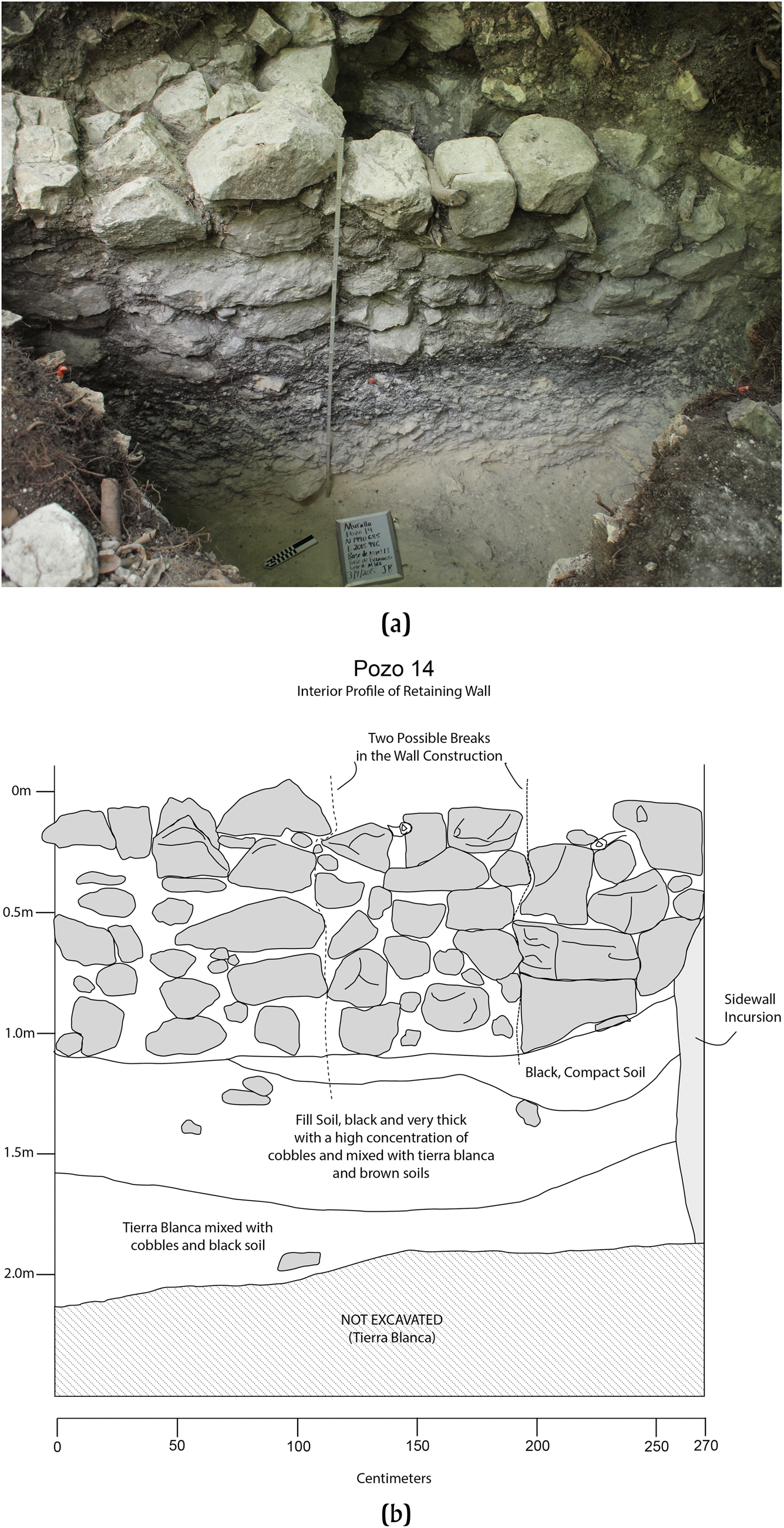
Figure 4. (a) Field photograph of excavation that exposed the interior face of the Late Preclassic enceinte wall. (b) Profile drawing of the interior face of the Late Preclassic enceinte wall. Photograph and drawing by the author.
Little to no evidence of Postclassic or later construction activity was recovered from these excavations, but the large amount of collapse scattered around the surface of the features may represent these periods. Other Postclassic ceramics from the top layers of other excavations, especially those into ceremonial contexts, confirm occupation during this time, as does the Temple Assemblage arrangement of the main ceremonial plaza (Rice and Rice Reference Rice and Rice1981:278–279). A description given by Pedro de Navarette in April 1702 of a “very strong fortification of slender stakes in the form of an O, with very astutely constructed entrances and exits” (as quoted in Jones [1998:385]) may refer to a palisaded construction at Muralla de León during that time (Rice et al. Reference Rice, Rice, Pugh, Polo, Rice and Rice2009:128). These later site occupants therefore maintained the defensive posture of the site that had been initially instituted at least 1,900 years before.
CENTRAL PETEN REGIONAL DYNAMICS IN THE LATE PRECLASSIC
Contextualizing the presence of a monumental fortification within a defensive site plan at Muralla de León during the Late Preclassic requires a look to the broader patterns taking place at the time. Substantial construction at Muralla de León appears to have been initially undertaken early in the Late Preclassic, coincident with the decline of Cerro Ortiz about 1.5 kilometers to the south, which had fairly intensive occupation through the Middle Preclassic (Rice and Rice Reference Rice and Rice1985; Rice Reference Rice and Macanché Island1987; Prudence Rice, personal communication 2018). Minor activity has been documented otherwise in the Macanche basin during this period at Yalain (Aguilar Reference Aguilar, Laporte and Arroyo2002; Rice et al. Reference Rice, Rice, Jones, Polo, Pugh, McNair, Cecil, Drake, Laporte and Escobedo1996), off of the northeast shoreline, and Group X1, a small architectural group on a rise along the north-central shoreline (Bracken Reference Bracken2021). Muralla de León was thus the largest site in the basin in the Late Preclassic, and the first substantial occupation encountered as one traveled west toward Lake Peten-Itza from Belize and the Lake Yaxha-Sacnab basin.
The Chicanel ceramics recovered from Muralla de León indicate the site's participation in the broader central Peten interaction sphere that was in place during this time, and its location at the eastern edge of the main cluster of lakes constituting the Peten Lakes region make it likely that it was a node along regional trade routes, perhaps functioning as a port or frontier site. The Yaxha-Sacnab basin to the east is considered to be part of the Peten Lakes Region; however, the fact that over 20 kilometers of land lies between that basin and Lake Macanche, while Lake Macanche is connected to the remaining lakes to its west by canals or short overland portages defines a central cluster that is functionally separate from Lakes Yaxha and Sacnab in terms of movement.
INVESTIGATING DEFENSIVE FUNCTIONALITY
Investigations into the proposed defensive functionality of the Preclassic monumental constructions at Muralla de León relied on excavations to uncover details of its form and evidence of active combat, as well as a statistical GIS investigation of affordances of movement and their relationship to the investment in rampart construction along the perimeter. The excavations showed that the enceinte existed even in locations where no surface indication appears at present, appearing in such locations as two concentric lines likely supporting a palisade wall between them (Figure 5). They also showed evidence for a walkway atop high portions the enceinte, possibly protected by a now-collapsed parapet wall, and a stepped form to the interior slope that likewise may have facilitated movement. Portions along the apex that were leveled and paved with stone, measuring roughly three meters on each side and indicated on the site map by squares, appear to be lookout or guard stations. Evidence for active combat, however, such as spent weaponry, skeletal trauma, or breached fortifications, was not observed (Bracken Reference Bracken2021).

Figure 5. Plan view drawing of the enceinte as it appears along the perimeter line near Group 1, consisting of two parallel wall lines that likely supported a palisade wall. Drawing courtesy of Omar Schwendener.
The movement analysis consisted of two parts that determined affordances of movement across the local landscape and calculated how those values interact with the constructed features. The purpose of the analysis was to establish first that the perimeter wall did function defensively in its Preclassic form. Secondly, it works to ascertain that Muralla de León was situated at an auspicious location within networks of likely travel, supporting characterization of the site as strategically located within Preclassic pathways of regional travel. The results of these analyses, as described below, act in conjunction with the excavation results and field observations to indicate the physical impact of warfare at occupied Maya sites from the early facet of the Late Preclassic period, as sociopolitical complexity spread across the Maya world.
Movement Analysis and Circuitscape
The movement of people from place to place—congregating, visiting friends and relatives, migrating, fleeing, conducting trade, invading, making a pilgrimage, and all other modes—is integral to the active constitution of culture and society. It is at the same time ephemeral, and therefore traceable only indirectly in archaeological study. As difficult as it can be today to recreate pathways of movement from the distant past, the potential insight they offer into past lifeways is huge, as they define both the extent and layout of daily experience at an individual scale. Thrift (Reference Thrift2008:8), in his Non-Representational Theory, describes the world as “made up of all kinds of things brought in to relation with one another by many and various spaces through a continuous and largely involuntary process of encounter,” emphasizing the movement of people and objects as the propulsive force behind experience, mediated by the spaces within which these interactions occur. Echoes of de Certeau (Reference de Certeau1984) and his notion of walking in the city resonate through this framing. Daily experience at the individual level is defined by the physical layout and character of one's surroundings, with factors impacting movement such as the weather, mode of transportation, the terrain, and the weather coalescing to determine the points of contact one has with the environment and other people. While an individual's itinerary on any single day may be somewhat random or arbitrary, the general patterning of their movement and interactions is significant, especially when considered in combination with the observable patterns across the entirety of the society to which they belong.
GIS-based analyses offer insight into the possibilities of movement across the past and present landscape through an approach known as least cost analysis (LCA; Surface-Evans and White Reference Surface-Evans, White, White and Surface-Evans2012). Useful for a variety of applications, especially engineering projects, LCA offers a means of characterizing a swath of terrain under investigation according to how conducive to travel the subareas that compose it, represented as raster cells, are with regard to defined parameters. Such analyses are useful for defining likely paths and corridors of movement, as well as barriers and other areas that obstruct movement The crucial element in determining the quality of the analysis and the relevance of its results to the real world are the elements incorporated into the friction surface (White Reference White2015). The relative weighting assigned to the various elements incorporated into this surface determines their significance as factors in influencing movement, and the friction surface is ultimately the input on which the analysis is run.
Much of the work involving LCA has traditionally relied on determining probable real-world (not simply straight-line) paths taken by humans between defined points (e.g., Richards-Rissetto and Landau Reference Richards-Rissetto and Landau2014; Rissetto Reference Rissetto, White and Surface-Evans2012), a robust tool for answering research questions related to the true distances and travel times for trips between areas of interest such as settlements and water sources. Some recent work in this vein has generalized the analysis to define affordances of movement for each cell within the defined area of study. While the value within each cell in a friction surface defines the difficulty in traversing it, the affordance of movement value for each cell is an output that defines how conducive it is to travel, and references the surrounding terrain instead of functioning in isolation (Howey Reference Howey2011). Furthermore, these affordances of movement are calculated independent of direction of travel, offering a general sense of the movement potential of that location by accounting for the fact that friction surfaces can be heavily directionally dependent. For example, in a steep location where uphill and downhill travel is difficult, walking perpendicular to the downslope can be flat and relatively easy.
These directionally agnostic determinations of affordance of movement have been accomplished using the Circuitscape program, operational as a stand-alone or as a plug-in script within ArcMap (McRae and Shah Reference McRae and Shah2009; McRae et al. Reference McRae, Shah and Edelman2016). Circuitscape simulates paths of movement across the friction surface from areas defined as sources to those defined as grounds in the manner of an electrical current. By running the program across the friction surface of interest four times, once in each cardinal direction, then cropping the outputs down to the central quarter and normalizing and combining the outputs, a robust value of movement potential can be determined for each cell. The cropping step is necessary to avoid edge effects, in which exaggerated values are obtained near the ground, source, or side boundaries due to the interplay of barriers in the friction surface and the arbitrary framing of the area of analysis. This format is referred to as a “wall-to-wall” analysis, due to the fact that for each run of the program, the cells along one entire edge of the area of analysis are defined set as source nodes and cells along the opposite edge as ground cells (Kohut Reference Kohut2018; Pelletier et al. Reference Pelletier, Clark, Anderson, Rayfield, Wulder and Cardille2014). For each directional run, the friction surface incorporates a slope value dependent on the direction of travel, thus accounting for the variable difficulty imposed upon travel by an inclined surface depending on its aspect, or the compass direction of its downslope.
RESEARCH DESIGN AND METHODS
Research Design
The primary question of this paper is whether warfare was an explicit factor in the development and spread of permanent sociopolitical complexity beyond the major population centers in the Maya lowlands. The use of the term “explicit” refers to visible physical manifestations of warfare constituting notable elements of the built environment as complexity developed. Having established the partial Late Preclassic form of the enceinte through excavation along with radiocarbon and ceramic dating, a first approach to addressing this goal is through GIS and spatialized statistical analysis of the functionality of the early enceinte form. This analysis addressed the affordances of movement and the variable height of the enceinte, seeking to determine whether more labor, and material investment was concentrated at locations of easiest access to the site interior. A second approach sought to determine whether Muralla de León's location was strategic within likely paths of movement across the region in the Late Preclassic period.
Methods
Circuitscape Analyses
To perform these investigations, two, full, wall-to-wall Circuitscape analyses, each incorporating four cardinal-directional runs of the program, were performed. For the first, a 5.5 × 5.5 km analysis was performed, establishing a detailed output map of affordances of movement around the Macanche basin. The map was created using one arc-second (30.87-m resolution) data from the Shuttle Radar Tomography Mission (SRTM), provided by the National Aeronautics and Space Administration (Farr et al. Reference Farr, Rosen, Caro, Crippen, Duren, Hensley, Kobrick, Paller, Rodriguez, Roth, Seal, Shaffer, Shimada, Umland, Werner, Oskin, Burbank and Alsdorf2007), in combination with point data collected within Muralla de León using a total transit station and handheld GPS units. The SRTM raster data was converted to a point feature class, then loaded into ArcMap 10.5.1 along with point elevation data collected at the site by the project and a polygon layer of water bodies. Using those three files as input data, the Topo to Raster tool then interpolated a hydrologically correct surface at 4-m resolution, a compromise value that maintained accuracy in the areas covered by the lower-resolution SRTM data while still preserving the subtle details obtained on the ground around the site. The water bodies layer incorporated into the DEM was a polygon feature class consisting of detailed shoreline tracings created for each body of water within the area of study after georeferencing maps and satellite imagery into ArcMap. For the second, a 100 × 100 km analysis was performed at 92.6-m resolution to assess affordances of movement and likely corridors of movement at a regional scale. Elevations for this coverage was obtained from three arc-second SRTM data.
Once directional slope values were calculated for each cell in the study area, to be used as an indicator of difficulty of travel, the cost value of each cell that fell within a polygon boundary representing a body of water was set to a value slightly lower than the overall average of the slope cells. In this way, the water bodies were set to be mildly conducive to traversing relative to land locations. This setting reflects the fact that over-water travel in canoes is documented ethnographically for both people and goods (Jones Reference Jones1998; Thompson Reference Thompson1949), and would have been advantageous in many situations in terms of energy expenditure and travel time.
Statistical Analysis of Fortification
The first Circuitscape map above and its affordance of movement outputs were then used as an input into the subsequent statistical analysis of fortification. For this step, the Muralla de León site perimeter was divided into 50 equal sections, each roughly 30 meters in length (Figure 6). To create each segment, one polygon was drawn to the exterior, following the slope and extending to the base of the exterior wall, and a second was drawn to the interior base in a similar manner. The format draws general inspiration from the Intrasite Fortification Analysis performed on hillfort sites in the Nazca region of Peru by McCool (Reference McCool2017).

Figure 6. Perimeter segments used for calculation of statistics. Image by the author.
The statistical outputs for the subsequent analysis (Table 1) were derived by overlaying these polygons upon the site. Outputs from the interior polygon provided the interior surface elevation that informed both response variables in the statistical analysis: wall height and wall volume. Wall height (ConstWallHeight) was calculated as the vertical rise from the minimum elevation value in the interior polygon to the elevation along the perimeter line of the segment (PointElevation). Meanwhile, the volume of the constructed portion of the wall in each segment (WallVol) was calculated by first creating a 3D representation of the site ground surface in the form of a Triangulated Irregular Network, or TIN. The Polygon Volume tool in ArcMap was then used to slice a plane through the enceinte portion in each segment, with the elevation of the plane set to the minimum elevation within the corresponding interior polygon. Volume was then calculated for the portion of the enceinte in that segment and above that planar slice, approximating the volume that was constructed above the natural landform. The exterior polygons provided the outputs for the explanatory variables, including average and maximum slope of the exterior face of the enceinte (ExtSlopeMean and ExtSlopeMax, respectively), height above the exterior base (ExteriorDrop), and average current value of the approach (CurrMean). The latter statistic was derived from the first Circuitscape analysis and used as a proxy for accessibility of the approach to that segment of perimeter wall. The derived statistical values for each segment are available in Table 2.
Table 1. Explanation of variables.

Table 2. Derived statistical values by segment.

Three series of multiple regression analysis were performed for these two response and five explanatory variables, each ending with a simple regression analysis using CurrMean as the explanatory variable. The first used ConstWallHeight as the response variable for each regression run. As each output within this series of analyses returned a significant value (p < 0.05) within the Breusch-Pagan test for heteroskedasticity (a term explained in detail in the Results section below), a second series of multiple regression analyses was run using log transformed values for ConstWallHeight. The third and final series of analyses used WallVol as the response variable, with no heteroskedastic issues encountered.
Linear regression was chosen instead of non-linear regression due to its ability to test for significance in the relationships and to assess the explanatory power of these relationships. It is supposed that the planners and builders made straightforward decisions regarding where to construct the enceinte to be taller and more imposing, targeting the most vulnerable locations and investing less effort into sections naturally protected by the landform. The goal of these statistical analyses was to test for such a correlation, determining whether accessibility can be isolated as the primary factor in explaining its variable height and volume, which would support interpretation of the construction as functionally defensive in intent. The second, regional analysis of affordances of movement looked more qualitatively for evidence of a corridor of movement passing through or near Muralla de León. The presence of such a corridor would be interpreted as support for the idea that the site served as a sort of entry point into the central lake cluster, while a more distributed pattern of movement through the area would disprove the idea.
STATISTICAL ANALYSIS OF FORTIFICATION RESULTS
DEM Creation
The first analysis began with the creation of the 4-m resolution DEM at 11 km on a side (Figure 7). The wall-to-wall Circuitscape procedure was then run four times across the surface, once in each cardinal direction. Each of those four outputs was then cropped to the central 25 percent, normalized, and combined into a final output map. That resulting map (Figure 8) is color-coded according to the relation of each cell to the mean value in standard deviation increments, with typical values in yellowish green, especially high affordances of movement in dark green, and especially low values in red. A corridor of movement toward Lake Yaxha, more complete and apparent in the output of the regional analysis below (Figure 9), can be seen in the southeast corner of the map, and a branch connecting it to Muralla de León can be seen running northwest from it. Statistics were then extracted from each of the 50 polygons around the site perimeter based on the cell-by-cell raster outputs from that analysis of affordances of movement around the Macanche basin in conjunction with the associated DEM, as described in the Methods section above and in Tables 1 and 2.

Figure 7. Frames for Circuitscape analysis. Image by the author.

Figure 8. Circuitscape analysis at 5.5 × 5.5 km. Image by the author.

Figure 9. Circuitscape analysis at 100 × 100 km. Image by Bracken.
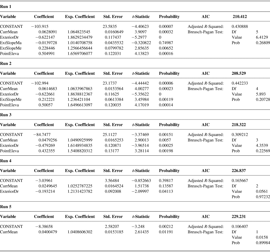
First Series of Multiple Regression Analyses
The complete results of the first series of multiple regression analyses using ConstWallHeight as the response variable is seen in Table 3. After using all five explanatory variables in Run 1, the variable with the highest probability value was removed for each subsequent run. In each case, the removed variable was not significant at the level of p < 0.01 in the last run before it was removed. According to the Akaike Information Criterion (AIC), the model with the best fit is seen in Run 2, which uses all but the ExtSlopeMax explanatory variable. These four variables together explain 46.15 percent of the observed variation in wall height, as indicated by the Adjusted R-squared value, but come out as significant at p < 0.01 in the Breusch-Pagan Test for heteroskedasticity, with a p-value of 0.00237. The results being heteroskedastic indicates that the variance within each variable is not randomly distributed, thus raising the possibility of their significant relationship to the response variable being a false positive. The false indication of significance derives from the fact that the observed correlation is being driven by a directional trend in the residuals rather than an interactive relationship between the response and explanatory variables.
Table 3. First series of multiple regression analyses with constwallheight as response variable.

The simple linear regression represented by Run 5, which uses only CurrMean as an explanatory variable, likewise registered the relationship as significant (at p < 0.001). The coefficient of 0.0326105 indicates that for every one unit increase in the CurrMean value, the constructed wall height rises 0.0326 m, or 3.2 cm. The Adjusted R-squared value of 0.2966, however, means that the CurrMean value only explains 29.66 percent of the variation in wall height. While this proportion is relatively small yet still significant, Run 5 suffers the same, larger issue of heteroskedasticity, with a Breusch-Pagan probability that is significant at p < 0.05, that all five runs in this first series suffer. Due to the likelihood of a false positive in the results registering as significant (in this case, the p-value of CurrMean), an amended approach needed to be taken.
Second Series of Multiple Regression Analyses
To overcome the issue of heteroskedasticity, a log transformation was applied to the ConstWallHeight response variable, which was then again run against the five response variables in a second series of multiple regression analyses that mirrored the format of the first (Table 4). By taking the logarithm of each instance of the ConstWallHeight variable, the residuals of the regression analysis became more symmetrically distributed while maintaining their suitability for analysis. Interpretively the unit changes represented in the output of the original linear regression above, in which a unit change in the explanatory variable correlates to a consistent change in the response variable, becomes a percent change.
Table 4. Second series of multiple regression analyses, with log-transformed constwallheight as response variable.
As was seen in the first series, the model with the best fit appears in Run 2, as determined by its AIC score being the lowest of the five runs. The four explanatory variables are all significant there at p < 0.001, and together explain 44.22 percent of the variability in the height of the enceinte. Furthermore, the Breusch-Pagan test does not register as significant, indicating that the results are not a false positive driven by heteroskedastic variances. In the Exp. Coefficient column, the coefficient has been exponentiated to show its impact upon the response variable. The results of Run 2 can be read to indicate that the enceinte is six percent higher in response to every unit increase in CurrMean, 86 percent lower in response to every meter increase in ExteriorDrop (due to the negative coefficient), 24 percent higher for every degree increase in ExtSlopeMean, and 65 percent higher for every meter increase in PointElevation. The positive PointElevation relationship was not expected, as it had been thought that higher points would need less protection, but it is also the case that a higher constructed enceinte segment would increase the PointElevation result, a covariance that had not been considered in advance.
In Run 5 of the second series of analyses, the simple linear regression of CurrMean in as an explanatory variable for the log transformed ConstWallHeight remained significant at p < 0.05 and was not heteroskedastic. The exponentiated coefficient, however, indicates only a four percent increase in wall height for every unit increase in CurrMean, while the Adjusted R-squared shows that only 11 percent of the variability in wall height is explained by the accessibility score provided by that variable. Thus, although the relationship is significant, the CurrMean variable is a weak indicator of the height of the constructed portion of the enceinte.
Third Series of Multiple Regression Analyses
The third series of statistical analyses, like the second, followed the template established by the first series. The response variable was switched to WallVol, and in these five runs heteroskedasticity never arose as an issue (Table 5). As in the previous two series, the model with the best fit (determined by the low AIC score) was again Run 2, which had an Adjusted R-squared of just 0.355. The fact that ExtSlopeMean is not significant at p < 0.05 in Run 2, however, means that Run 3, which excludes that variable and has an AIC score only marginally higher, may better lend itself to discussion here. The Run 3 model was able to explain 34 percent of the variation in enceinte volume. In this model, for every unit increase in CurrMean, the enceinte volume increases 14.6 m3, every meter increase in ExteriorDrop reduces the enceinte volume by 78.9 m3, and every meter increase in PointElevation increases the enceinte volume by 92.0 m3. The low Adjusted R-squared value, however, means that these variables are not a powerful explanatory force for the variation in enceinte height around its perimeter.
Table 5. Third series of multiple regression analyses, using wallvol as response variable.

In Run 5, the simple linear regression is significant at p < 0.001 and is not heteroskedastic. The coefficient indicates that a one unit increase in CurrMean increases the enceinte volume by 11 m3, but the Adjusted R-squared shows that this relationship accounts for only about 20 percent of variation in enceinte volume. Thus, although the relationship between accessibility and enceinte volume is stronger than was seen with enceinte height in the Run 5 of the second series above, it is still not a powerful relationship, with CurrMean explaining only about one-fifth of the variation seen in WallVol.
REGIONAL PATHS OF MOVEMENT ANALYSIS RESULTS
The second analysis used an initial DEM coverage of 200 × 200 km to provide the ultimate 100 × 100 km output area. This initial extent covered most of what is now the Peten department of Guatemala, excluding its western extreme, as well as a small segment of Mexico to the north and extending 37–44 kilometers eastward into what is now Belize (Figure 7). The cropped middle quarter, the output of the analysis, covers the entirety of the Peten Lakes Region in addition to its surroundings, particularly to the north and south. After performing the four wall-to-wall Circuitscape runs, then cropping and normalizing each, they were likewise combined into a single final map, color-coded in the same manner as the output map from the first analysis above (Figure 9).
A few patterns can be deduced visually from the map. From the north-center, the Buenavista Valley corridor provides easy movement from Uaxactun down near Jimbal and Tikal, then directly through El Palmar and El Zotz as it moves west and south, wrapping around toward Lake Sacpuy and the western extreme of Lake Peten-Itza. The results in the Buenavista Valley corridor reflect higher-resolution, path-dependent findings by Doyle and colleagues (Reference Doyle, Garrison and Houston2012). The area around Lake Peten-Itza is generally conducive to movement, though the rolling hills to its south limit easy access. The one north-south corridor that appears directly south of the site of Cenote is the path taken by the present-day highway toward Guatemala City.
A channel of high movement affordance emerges south of Lake Macanche at the eastern edge of that central Peten Lakes cluster, running east and then north to the shores of Lake Yaxha. Hemmed in by the hills that extend along the southern edge and the abrupt uplift north of Lake Macanche and continuing east, this corridor marks the likely path of travel between the central Peten Lakes cluster and sites in the Yaxha-Sacpuy basin as well as Belizean sites beyond. While other lines of evidence and ground-truthing would serve to indicate this route more positively as the one taken by past travelers, the substantially higher cost of travel by other paths suggests that access to the central Peten Lakes cluster required passing through or very near to Muralla de León.
INTERPRETATIONS
A defensive interpretation for the constructions at Muralla de León was inferred from time of early archaeological investigation at the site (Rice and Rice Reference Rice and Rice1981) and throughout the current project (Bracken Reference Bracken2016, Reference Bracken2021), based on the scale and general design of the encircling stone wall. The first approach to analysis performed here, the three series of regression models that combined GIS with spatial statistics, suggested a significant but weak correlation between accessibility from the exterior and both the constructed height and volume of the associated segment of the enceinte. Based on on-the-ground observations during fieldwork and qualitative review of the site map created by the project, it was thought that this correlation would be much stronger. While the result does not preclude the enceinte having been built toward defense, it likewise does not strongly support an exclusively defensive intent behind the construction.
A few factors may account for this discrepancy. First, the goals of the construction effort were almost certainly varied, with hydraulic control as a likely additional purpose behind the design (Bracken Reference Bracken2016, Reference Bracken2021). Height and volume fluctuations around the perimeter may have therefore been impacted as well by considerations of water channeling and pooling to the interior. Secondly, functional defense may not have been a driving factor behind the enceinte design. Rather, it may have only been intended to appear impressive and impenetrable, a bluff that only a brave or knowing attacker would try to call. Taken further, defensibility could have been absent in planning considerations. It seems highly unlikely, however, that the documented volume and form of the enceinte could have served any other practical purpose, even exclusively hydraulic control, as the modeled hydraulic effects of the constructions could have been accomplished with far less labor investment.
Third, the structure of the statistical analysis may be flawed, an instance of the modifiable areal unit problem (Openshaw Reference Openshaw1984). The arbitrary boundaries drawn at equal intervals to define the segments of analysis created areas that often captured a variety of landforms within. In developing the method, it was thought that each 30-m extent was small enough that the statistics derived from it would be representative of the area. Elements such as the abrupt rise of the enceinte in locations including the south-central extent and its abrupt disappearance in other sections, however, are significant attributes that were probably blunted or negated in the final analysis as a result of the sectioning. A follow-up analysis that uses the possibilities offered by spatial statistics to assess patterns along the perimeter in a continuous manner, precluding the need to use segments, is currently being developed by the author. Despite the weakness of the statistical correlation, the relationship between accessibility and both height and volume of the enceinte was still significant. Thus, a defensive intent almost certainly provides at least a partial explanation behind the enceinte. Observations made during excavation into it, including a steep, smooth, plastered exterior and the possible stone parapet wall running along the top, suggest that the perimeter wall was functionally defensive.
The second, regional paths of movement analysis performed here indicates that the site location would have been strategic within the networks of regional movement in the Late Preclassic period. Whether this movement solely took place over land or was aided by waterborne segments, Muralla de León sat directly within the major corridor of travel between the core of the Peten Lakes Region, especially Lake Peten-Itza and sites around it, and points west including the Yaxha-Sacnab basin, sites located in modern-day Belize, and the Caribbean coast. In conjunction with the Chicanel ceramics recovered from the lower levels of excavations into the main ceremonial groups within the site, this result supports the notion that Muralla de León was involved in the Central Peten interaction sphere of the Late Preclassic.
DISCUSSION
What activities, then, were taking place at Muralla de León in the Late Preclassic that compelled construction of the monumental enceinte and associated site layout? Whatever its intent, the construction effort resulted in a highly visible and legible feature that physically altered patterns of movement, defined a restricted space, and conceptually projected the unity of the polity residing there, contributing to a sense of identity. Though the interaction spheres as described begin to fill in detail as to the political geography of the era, it currently remains unknown what forces were commanding developments at the time in the Macanche basin. Whether Muralla de León represents residents coalescing in response to increased encroachment by external forces, or instead a borderland outpost established by an expansionary power, centered perhaps at Nixtun-Ch'ich’, Tikal, or El Mirador, is unclear.
If the site grew to its Late Preclassic prominence as the result of local developments, it did so within the context of strong interaction with the Central Peten interaction sphere. Ceremony within Groups 1 and 3 was an active element during this time, and the sparsely occupied space within the enceinte surrounding these groups could have accommodated the basin population for periodic gatherings. To the degree that the enceinte did function defensively, the population could likewise have sought refuge within in case of attack. The nearly 80,000 person-days of labor required to complete the enceinte is impressive but would only require a work force of 219 individuals working eight hours a day for a full year to complete. The Late Preclassic population estimate for the basin, 1,070.8 individuals (Rice and Rice Reference Rice, Rice, Patrick Culbert and Rice1990:145, Table 6.6), could easily have therefore accomplished this task in a reasonable amount of time, even accounting for a partial workforce or fewer hours or days per week worked on average.
The likely paths of regional movement as determined by the second investigation here highlight the possibility that the site rested along important trade paths in the Late Preclassic, perhaps functioning as an important node in the form of a port or entrepôt, as seen at nearby Ixlu in later periods (Rice and Rice Reference Rice and Rice2016). The site's placement both at the eastern edge of the Eb ceramic sphere and along a probable corridor of east-west movement suggests that traders and others were moving regularly through the immediate area and the site itself. Amid the traffic passing through the area, it would have been crucial for the powers controlling Muralla de León at the time to project a sense of control and strength. Whether those in power were a local force or one exerting authority from afar, the threat of takeover or raids upon the auspicious location would have been ever-present, especially if controlling passage through was the source of the site's wealth.
A defensive function for the enceinte at Muralla de León has long been assumed by investigators and others familiar with the site, an interpretation not at odds with the possible significance of trade mentioned above. The thickness and height of the stone wall, the apparent gates, and its enclosure of the entire perimeter strongly imply that it is a fortification, while the bastion and bank-and-ditch below to the southeast indicate an undoubtedly defensive posture by the Early Classic. The goal of the investigation as it was structured here was to confirm this defensive assumption for the enceinte quantitatively and beyond reproach, establishing it as an explicit element of warfare with which the Late Preclassic Macanche basin society would have negotiated as sociopolitical complexity was being permanently established. This goal was partially realized by the statistical analysis. Functional defense was a significant consideration in the design of the main wall system as it was established in the Late Preclassic, but other influences also contributed to its established form. Defensive functionality seems to have been attained by focusing construction efforts on naturally accessible locations. Establishing this elevated stone perimeter, even in incomplete segments, would have inherently altered the local hydrology. Perhaps the efforts toward hydraulic control emerged from observation of the hydrological effects of initial construction of the enceinte, or conversely these effects were anticipated and planned into the design of the main wall system from the start. A detailed chronology of the construction effort is crucial to resolving such issues; the temporal resolution of these features, however, remain relatively coarse due to their indistinct stratigraphy and paucity of datable material.
If defense was the primary purpose of the enceinte, raiding appears to be a reasonable proposal as to what it was protecting against. The logistical difficulties of supplying a large fighting force at a long distance in the Maya lowlands makes the threat of a sustained siege or other heavy attack especially unlikely in the Preclassic, when overall populations were lower. Additionally, no available evidence supports the presence of large Maya militaries at the time, though future finds could overturn that notion. An alternative possibility, that the enceinte protected against capture and control of the site as a strategic node within regional networks of movement, cannot be ruled out.
Warfare is a broad category that takes on a wide range of forms, and it would be a mistake to unquestioningly project later notions of scale, organization, practice, and goals back to the Late Preclassic. The defensive posture of Muralla de León in the Early Classic and later periods may have grown out of a non-defensive initial layout or, as appears likely, a more tempered defensive form that assimilated other influences in its design. While in the Preclassic the greatest threat faced may have been opportunistic raiding, the larger populations, and more powerful polities across the Peten Lakes Region in the ensuing Classic period would have provided the resources for a more substantial military threat. Augmentations to the Muralla de León enceinte in sections during the Early and Late Classic as the population of the Macanche basin increased, eventually growing to triple the Late Preclassic levels before plummeting again after the Late Classic collapse (Rice and Rice Reference Rice, Rice, Patrick Culbert and Rice1990), may reflect a greater and more immediate threat at the time.
CONCLUSION
The analysis here established that the main wall system at Muralla de León functioned as a fortification in the Preclassic, though other considerations influenced its design. Thus, the research question of whether warfare was an explicit factor in the process by which sociopolitical complexity developed in the Macanche basin can be answered in the affirmative. The defensive purpose to the enceinte, however, appears interlinked with other goals, including hydraulic control, the projection of impenetrability, and other signaling associated with monumentality such as control of labor and circumscription of space. Later augmentations to portions of the enceinte, along with the construction of the southeast bastion and bank-and-ditch, speaks to a shift toward an unqualified defensive posture, as does the use of encircling palisades in the early 1700s. Follow-up analyses into the form of the enceinte will complement the more robust understanding of the Preclassic political landscape that continues to emerge from current investigation across the region.
The Late Preclassic constructions at Muralla de León represent a monumental labor effort that reshaped the local terrain and patterns of movement across it, establishing a prominent, legible site form visible to occupants all around the Macanche basin. The actions taken to organize the construction established new relationships between individuals and new identities, as did the finished product in terms of the area it circumscribed and the notions it projected to observers. The spatial layouts inscribed on the landscape and the impacts they had upon settlement in relation to them were driven by the circumstances present at the time but influenced patterns of development for many generations that followed.
RESUMEN
En ausencia de registros históricos, etnografía o representaciones artísticas, las fortificaciones proporcionan una de las mejores formas de evidencia para comprender la naturaleza de la guerra en sociedades pasadas. Las excavaciones en el muro perimetral de piedra, de 1,50 km de circunferencia, en Muralla de León, Región de los Lagos de Petén, han fechado su construcción inicial en los dos primeros siglos del preclásico tardío (400–200 a.C.). La investigación de esta aparente fortificación ofrece una nueva perspectiva del asentamiento maya y la construcción monumental en relación con la guerra fuera de los principales centros de población en esta era, a medida que la complejidad sociopolítica se generalizó cada vez más en las Tierras Bajas del Sur. Los cálculos de las posibilidades de movimiento en el paisaje local utilizando SIG y Circuitscape informan un análisis estadístico espacial de la fortificación en Muralla de León, realizado para probar una hipótesis de funcionalidad defensiva para el muro perimetral circundante. Una oferta separada de análisis de movimiento a escala regional ubica el sitio dentro de probables trayectorias de viaje entre sitios. La investigación indica una intención defensiva significativa, pero no exclusiva, que sustenta la forma Preclásica del sistema de muro principal. Así, el sistema fue construido en parte para funcionar como una fortificación, restringiendo el movimiento hacia el interior, al tiempo que facilitaba otros usos como el control hidráulico y posiblemente el comercio.
ACKNOWLEDGMENTS
I would like to thank my advisor, Dr. Timothy Pugh, as well as Evelyn Chan Nieto, Sheily Hernandez, Omar Schwendener, and Gerson DeJesus Rivera Lopez for their support on the project these last few years. Thank you as well to the three anonymous reviewers who offered such detailed comments on the drafts. Your careful reading of the text was evident, and the notes you provided resolved some important issues for the final, published version. Dr. Christopher Hernandez also provided essential insight as I developed the article and collaborating with him as coeditors of this Special Section has been a pleasure. I would also like to thank my wife Cailin Sandvig, Milo and Aurelia the babies, my parents Doug and Nina Bracken, and Jeremy the dog for all they have done to help me complete my work. This research was supported by a National Science Foundation Doctoral Dissertation Improvement Grant (BCS# 1836317).


