


INTRODUCTION
We welcome the comments offered by Schuster and Nutz on our publication (Boës et al., Reference Boës, Prat, Arrighi, Feibel, Haileab, Lewis and Harmand2019). We are glad to interact with our peers and we are open to any fair comments, remarks, and criticisms that could give us a chance to improve our understanding of the evolution of the Turkana Basin. Here, we are very pleased to give our point of view on the scientific questions they raise.
Schuster and Nutz (this issue) base their comment on the work by Nutz et al. (Reference Nutz, Schuster, Boës and Rubino2017). That article presents photointerpretations of some eroded coarse sedimentary facies (very high-energy systems) observed at the bottom of the Kaitio Member (Nachukui Formation, West Turkana, Kenya). The dating of their geologic sections (~40 m thick) is based on one ash layer (1.87 Ma, “KBS Tuff”) that is not demonstrated by a geochemical analysis. This chronostratigraphy is interpreted in terms of 400 ka eccentricity and 20 ka precession cycles.
The article by Boës et al. (Reference Boës, Prat, Arrighi, Feibel, Haileab, Lewis and Harmand2019) that Schuster and Nutz criticize presents a geologic section (110 m thick) going from the top of Lokalalei Member up to the bottom of Kaitio Member (below the eroded high-energy systems). Ash layers at 2.4 Ma (Kokiselei Tuff) and 1.87 Ma (“KBS Tuff”) date the bottom and top. Two other intermediate dated ash layers constrain the chronostratigraphic model at 2.33 Ma and 2.27 Ma (Kalochoro Tuff and Tuff G; see the geochemistry of the ash layers in Boës et al. [Reference Boës, Prat, Arrighi, Feibel, Haileab, Lewis and Harmand2019]). The stratigraphy measured with a total station ends 15 m below the “KBS Tuff,” because Boës et al. studied the section 1 presented by Nutz et al. (Reference Nutz, Schuster, Boës and Rubino2017), and because the high-energy facies above the “KBS Tuff” are eroded (and undated). The cross-study of volcanic and sequence stratigraphy with the total station allows Boës et al. to investigate the cyclostratigraphy between 2.4 and 1.87 Ma.
In their comment, Schuster and Nutz say that we (Boës et al., Reference Boës, Prat, Arrighi, Feibel, Haileab, Lewis and Harmand2019) did not properly transcribe their stratigraphic facies and that we transformed their periodicities. Here, we would like to underline that the imputation of misrepresenting the data from Nutz et al. (Reference Nutz, Schuster, Boës and Rubino2017) in Boës et al. (Reference Boës, Prat, Arrighi, Feibel, Haileab, Lewis and Harmand2019) is baseless. That Schuster and Nutz lay claim to “observed geologic facts” in contradiction with the interpretations of Boës et al. is based on shaky documentation presented in their original work. Schuster and Nutz's criticisms are addressed subsequently.
THE RELATIONSHIPS BETWEEN STRATIGRAPHIC FACIES AND BATHYMETRY IS OVERINTERPRETED
Schuster and Nutz (this issue) question the identification of a “prominent sandstone” as a foreshore (shallow-water) facies, preferring a deeper-water turbidite origin (first remark on their comment). However, in their original work (Nutz et al., Reference Nutz, Schuster, Boës and Rubino2017) they note that these sand beds lack any of the internal structures diagnostic of turbidites and instead rely on their interpretation of water depth as the defining criterion (“offshore muds” termed “U1”; depth below 15 m). In fact, these sandstones are rich in the trace fossil Piscichnus, interpreted to be fossil fish nests excavated in relative shallow-water environments (Feibel, Reference Feibel1987). This is not compatible with the permanent deep system interpreted by Schuster and Nutz.
The “coastal sand and shells” of the sequence reported by Nutz et al. (Reference Nutz, Schuster, Boës and Rubino2017) should be strictly interpreted as upper shoreface and foreshore (−3 to 0 m) according to Schuster and Nutz (second remark on their comment). Their recommendation is in contradiction with their own original work (Nutz et al., Reference Nutz, Schuster, Boës and Rubino2017) where this unit (termed “U2”) is associated with shoreface, foreshore, beach, and backshore (−3 to + 2 m ; see the photointerpretations of beach berms and paleosols presented by Nutz et al. [Reference Nutz, Schuster, Boës and Rubino2017]).
The “oncolites rich silts and sands” of the sequence reported by Nutz et al. (Reference Nutz, Schuster, Boës and Rubino2017) is also problematic. Schuster and Nutz consider as an “established geologic fact” that oncolites are associated with a bathymetry of –15 to –5 m. However, it is an overinterpretation of the initial work of Nutz et al. (Reference Nutz, Schuster, Boës and Rubino2017, p. 238), which mentions for this unit (termed “U3”) that “wave or storm reworking is suspected to have taken over oncolites in the shore zone and to have deposited them in the lower shoreface to the transition zone.” Schuster and Nutz's bathymetric reconstruction is overinterpreted and impossible given the archaeological context and the magnetostratigraphy presented by Lepre et al. (Reference Lepre, Roche, Kent, Harmand, Quinn, Brugal, Texier and Feibel2011; see also Roche et al. [Reference Roche, Brugal, Delagnes, Feibel, Harmand, Kibunjia, Prat and Texier2003] and Fig. 1). Oncolites are well known to form within the foreshore (–2 to 0 m), and they can even be emerged.
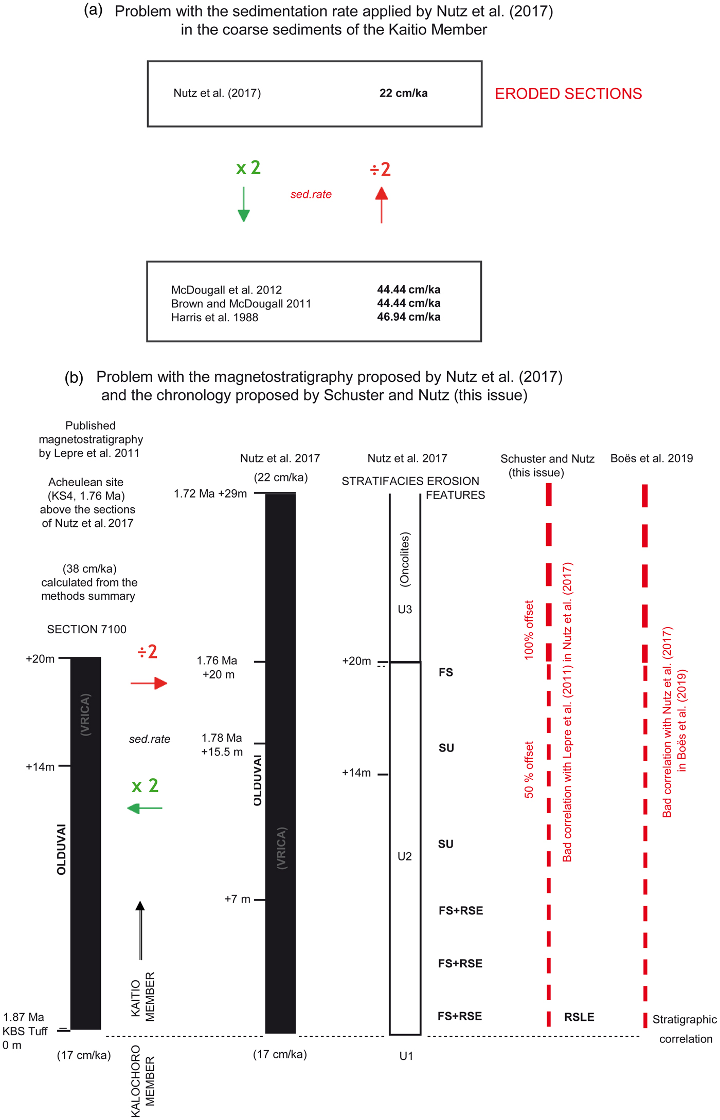
Figure 1. (color online) Problems with the geologic sections from Nutz et al. (Reference Nutz, Schuster, Boës and Rubino2017) partially reported in Boës et al. (Reference Boës, Prat, Arrighi, Feibel, Haileab, Lewis and Harmand2019). (A) Comparison between the sedimentation rate in Nutz et al. (Reference Nutz, Schuster, Boës and Rubino2017) and in Harris et al. (Reference Harris, Brown and Leakey1988), Brown and McDougall (Reference Brown and McDougall2011), and McDougall et al. (Reference McDougall, Brown, Vasconcelos, Cohen, Thiede and Buchanan2012). By contrast, the sedimentation rate applied by Nutz et al. (22 cm/ka) in their high-energy facies above the “KBS Tuff” is almost divided by a factor of 2. According to the method summary in Lepre et al. (Reference Lepre, Roche, Kent, Harmand, Quinn, Brugal, Texier and Feibel2011), a more correct sedimentation rate is 38 cm/ka, which is in agreement with the other published rates for these high-energy facies observed in the Kaitio Member. The sedimentation rate of “22 cm/ka” mentioned by Nutz et al. for the coarse sediment package (U2 and U3) resembles the sedimentation rate attributed to the much lower energy environments (10 to 20 cm/ka), typical for the Kalochoro Member (~45 cm/ka). Note the ages calculated with the sedimentation rate of 22 cm/yr are not correct in the original article by Nutz et al. (Reference Nutz, Schuster, Boës and Rubino2017). For example, we should obtain 1.76 Ma at 24 m and not at 20 m. (B) Compared with Lepre et al. (Reference Lepre, Roche, Kent, Harmand, Quinn, Brugal, Texier and Feibel2011), the magnetostratigraphy of Nutz et al. (Reference Nutz, Schuster, Boës and Rubino2017) is divided by a factor of 2. Nutz et al. have represented the Olduvai and Matuyama transition, although this transition is not even present in their sections (see the supplementary material in Lepre et al., Reference Lepre, Roche, Kent, Harmand, Quinn, Brugal, Texier and Feibel2011). Consequently, the position of the Olduvai-Matuyama transition in Nutz et al. presents an offset of 100% with the magnetostratigraphy of Lepre et al. (Reference Lepre, Roche, Kent, Harmand, Quinn, Brugal, Texier and Feibel2011). The correlation with the archaeological context of KS4 (1.76 Ma; Lepre et al., Reference Lepre, Roche, Kent, Harmand, Quinn, Brugal, Texier and Feibel2011) is wrong. The top part (U2–U3) of the sections of Nutz et al. (Reference Nutz, Schuster, Boës and Rubino2017) presents a very bad correlation with Lepre et al. (Reference Lepre, Roche, Kent, Harmand, Quinn, Brugal, Texier and Feibel2011) and Boës et al. (Reference Boës, Prat, Arrighi, Feibel, Haileab, Lewis and Harmand2019). Note that Lepre et al. completed the correlation between their sections following the magnetostratigraphy only and not according to the stratigraphic facies that changes laterally because of disconformities and erosional features. Observed erosion features and disconformities: RSE, regressive surface of erosion; RSLE, regressive surface of lake erosion; SF, surface flooding; SU, subaerial unconformity (see Nutz et al., Reference Nutz, Schuster, Boës and Rubino2017; Schuster and Nutz, this issue).
THE INTERPRETATION OF THE CHRONOLOGY AND PERIODICITIES IS OVERINTERPRETED
Schuster and Nutz's chronology and periodicities (third remark on their comment) are based on problems with the chronostratigraphic model originally reported by Nutz et al. (Reference Nutz, Schuster, Boës and Rubino2017). Their “long-term trend” is based on three segments (“U1, U2, and U3”) separated by disconformities of variable temporal significance. Although these segments are separated by erosion features and undated time gaps, they considered their sections as “continuous” and “complete,” and they inferred an age span of 1.95–1.72 Ma. Nutz et al. lacked any direct age control on their “observed” chronostratigraphic gaps (see “RSE, FS, SU” in Nutz et al. [2017] and “RSLE” in Schuster and Nutz [this issue]; see also Fig. 1). Each truncated sedimentary pile is placed end to end (U1/1.95–1.87 Ma; U2/1.87–1.76 Ma; U3/1.76–1.72 Ma), and their “observed regressive and transgressive trends” are built from that technique.
Apart from the problem of applying a continuous chronostratigraphic model in discontinuous and incomplete time series, the total duration of the sections investigated by Nutz et al. (Reference Nutz, Schuster, Boës and Rubino2017) appears to be of 70 to 130 ka maximum (Fig. 1). The offset is nearly equivalent to a 100 ka insolation period, or three to five precession cycles. Even in their original publication, Nutz et al. (Reference Nutz, Schuster, Boës and Rubino2017) have overinterpreted their data. How could the 400 ka periodicity be “observed” from their “230 ka” (1.95–1.72 Ma) time series? In Harris et al. (Reference Harris, Brown and Leakey1988), Brown and McDougall (Reference Brown and McDougall2011), and McDougall et al. (Reference McDougall, Brown, Vasconcelos, Cohen, Thiede and Buchanan2012), the sediment accumulation rate is multiplied by a factor of 2 above “KBS,” and the type section dated between 1.87 and 1.76 Ma represents 130 m of sediments. How could only 20 m of eroded “U2” sediments in Nutz et al.’s (Reference Nutz, Schuster, Boës and Rubino2017) sections represent a “complete record” with four to five consecutive 20 ka cycles? What Shuster and Nutz consider as “established geologic facts” presents an offset of 50% with the sedimentation rates of Harris et al. (Reference Harris, Brown and Leakey1988), Brown and McDougall (Reference Brown and McDougall2011), and McDougall et al. (Reference McDougall, Brown, Vasconcelos, Cohen, Thiede and Buchanan2012). The offset is of 50–100% with the magnetostratigraphy of Lepre et al. (Reference Lepre, Roche, Kent, Harmand, Quinn, Brugal, Texier and Feibel2011) (see Fig. 1).
Finally, we do not think that Schuster and Nutz's remarks are justified because they have few arguments for challenging other scientists based on their 2017 article (see also the reply from Lupien et al. [Reference Lupien, Russell, Feibel, Beck, Castãneda, Deino and Cohen2018b] and the original work by Lupien et al. [Reference Lupien, Russell, Feibel, Beck, Castãneda, Deino and Cohen2018a]).
ACKNOWLEDGMENTS
Our research is funded by the ANR-12-CULT-0006 (Agence Nationale de la Recherche), by the Ministère des Affaires Etrangères (Direction générale de la mondialisation, du développement et des partenariats, N°681/DGM/ATT/RECH, N°986/DGM/DPR/PRG), the LSB Leakey Foundation, OASIC/AAP2017-UMI-CNRS- France (Project MobHom), and NTM INDIGO-France. We thank Rachel Lupien for constructive discussions.

