


1. Introduction
The lower Cambrian sedimentary rocks of NW France include both siliciclastics and carbonates, and contain strata of both continental and marine origin (Fig. 1). The rocks preserve a record of sedimentation prior to the evolution of land plants, and at a time in Earth history when life on Earth developed rapidly in the oceans (Seilacher, Reference Seilacher1999; Bottjer et al. Reference Bottjer, Hagadorn and Dornbos2000; Mángano & Buatois, Reference Mángano and Buatois2017). The lower Cambrian strata of NW France and the neighbouring Channel Islands is, as a result, popular for research. Numerous case studies have taken advantage of the well-preserved and locally well-exposed nature of the strata to investigate processes associated with pre-vegetation sedimentation in terrestrial environments and through the continental–marine transition (e.g. Todd & Went, Reference Went1991; Suire et al. Reference Suire, Dabard and Chauvel1991; Went, Reference Went2005, Reference Went2020; Ielpi & Ghinassi, Reference Ielpi and Ghinassi2016; McMahon et al. Reference McMahon, Davies and Went2017; Went & McMahon, Reference Went and McMahon2018). The marine strata contain localized primitive invertebrate fossil material with which it is possible to constrain the ages of the rocks. However, the discontinuous nature of the outcrop over NW France combined with variations in facies has effectively precluded the development of an effective regional stratigraphic framework. The purpose of this article is to present an interpretation of the lower Cambrian sequence stratigraphy of Normandy that explains the observed facies and stratigraphic variations, and which allows for a reconstruction of the architecture of the basin fills. The reconstruction provides the foundation for an evaluation of the factors controlling basin-wide processes of sedimentation during early Cambrian time. A lack of land plants is demonstrated to have influenced depositional style through the fluvial–marine transition. A limited marine invertebrate fauna impacted on the distribution and abundance of microbial life forms through marine and non-marine settings. The localized development of super-mature quartz arenite is related to high-energy marine processes operating on a shelf subject to transgression and low rates of sediment aggradation.

Fig. 1. (a) Location of study area in NW France. (b) Simplified geological map of Normandy and Brittany showing an outline of the main study area (dashed rectangle). Outcrops of Cambrian strata, shown in green, in Normandy, Brittany and Pays de Loire: 1, Alderney; 2, Hague; 3, Rozel; 4, Carteret; 5, Lessay; 6, Jersey; 7, Montmartin; 8, May; 9, Urville; 10, St Rémy; 11, Pont-Farcy; 12, Erquy; 13, Bréhec; 14, Pail; 15, Ecouves; 16, Alpes Mancelle; 17, Perseigne; and 18, Couvron-Charnie. (c) Chronostratigraphic chart of the Cambrian Period showing the stratigraphic setting of the study intervals.
2. Geological setting
The rocks of the study area are predominantly of late Precambrian and lower Palaeozoic age (Fig. 1a). They relate to the Cadomian orogenic cycle and the subsequent opening of the Rheic Ocean (D’Lemos et al. Reference D’Lemos, Strachan, Topley, D’Lemos, Strachan and Topley1990; Linnemann et al. Reference Linnemann, Gerdes, Drost and Buschmann2007, Reference Linnemann, Pereira, Jeffries, Drost and Gerdes2008; Nance & Linnemann, Reference Nance and Linnemann2008; Murphy & Nance, Reference Murphy and Nance2013). Precambrian rocks include crystalline basement overlain by a cover of sedimentary and volcanic rocks, which were folded and deformed during the Cadomian Orogeny. Erosion of the Cadomian uplands shortly followed the orogenic climax at c. 540 Ma (Peucat, Reference Peucat1986). This resulted in the deposition of lower Cambrian red beds and shallow-marine strata in extensional basins (Went & Andrews, 1990; Linnemann et al. Reference Linnemann, Pereira, Jeffries, Drost and Gerdes2008; Went, Reference Went2017). The Cambrian strata include a mixture of siliciclastic and carbonate rocks with scarce body fossils. Upper Cambrian strata are absent from the main study area, reflecting a period of broad regional uplift during this time (Doré, Reference Doré1972; Doré et al. Reference Doré, Juignet, Larsonneur, Pareyn and Rioult1977). Lower Ordovician strata are widespread over both Normandy and Brittany and reflect a period of renewed subsidence and marine transgression associated with the opening of the Rheic Ocean (Paris & Robardet, Reference Paris and Robardet1990; Nysaether et al. 2002; Murphy et al. Reference Murphy, Gutierrez-Alonso, Nance, Fernandez-Suarez, Keppie, Quesada, Strachan and Dostal2006; Nance et al. Reference Nance, Gutiérrez-Alonso, Keppie, Linnemann, Murphy, Quesada, Strachan and Woodcock2010, Reference Nance, Gutiérrez-Alonso, Keppie, Linnemann, Murphy, Quesada, Strachan and Woodcock2012; Murphy & Nance, Reference Murphy and Nance2013). Closure of the Rheic Ocean during Carboniferous time led to folding, uplift and erosion. The Palaeozoic strata, including the Cambrian, are typically preserved in synclines formed by the Carboniferous folding, and are separated by belts of Precambrian basement (Fig. 1a).
3. Methods
The thickness and facies characteristics of the lower Cambrian deposits in the various outcrops of the study area are shown in Figure 2. The major lithological subdivisions accord with the mapped successions of the BRGM (French Geological Survey), as summarized in Doré (Reference Doré, Chantraine, Rolet, Santallier, Piqué and Kleppie1994). No region-wide lithostratigraphic scheme to correlate the units exists. Rather local formation names, shown in Figure 2, are assigned to distinct lithological units present at different outcrops throughout the Channel Islands and Normandy. This approach reflects a lack of continuity of outcrop and a difficulty in correlating strata between geographic locations.

Fig. 2. (a) Facies associations of the lower Cambrian strata at key localities in Normandy. Abbreviations show the lithostratigraphy: ASF – Alderney Sandstone Formation; COF – Couville Formation; LRF – Le Rozel Formation; CAF – Carteret Formation; SJR – St Jean de La Rivière Formation; BF Bosquet Formation; RCF – Rozel Conglomerate Formation; HF – Hyenville Formation; SCF – Siltstones and Limestones Formation; CF – Caumont Formation; RF – Rocreux Conglomerate Formation; PMF – Pont de la Mousse Formation; SRF – St Rémy Formation; EF – Erquy Formation; FF – Fréhel Formation; PL – Port Lazo Formation; RJF – Roche Jagu Formation. (b) Sequence stratigraphic model and correlation of strata. LST – Lowstand systems tract; TST – transgressive systems tract; HST highstand systems tract; SB – sequence boundary. (c) Location map showing line of section.
Detailed independent fieldwork has been carried out at the coastal localities at Alderney, La Hague, Cap Rozel, Carteret, Jersey, Lessay (Pirou Plage), Bréhec and Erquy-Cap Fréhel (e.g. Went et al. Reference Went, Andrews and Williams1988; Todd & Went, Reference Went1991; Went, Reference Went1991, Reference Went2005, Reference Went2017, Reference Went2020; Went & Andrews, Reference Went and Andrews1991; McMahon et al. Reference McMahon, Davies and Went2017; Went & McMahon, Reference Went and McMahon2018). Extended reconnaissance field visits were made to the inland exposures at May sur Orne, Urville, St Rémy, Montmartin and Pont Farcy to verify the lithological successions, identify facies and to collect specific supplemental data of relevance to studies of the basin fill (e.g. grain size, palaeocurrents, ichnofacies). Other than at Urville, where no exposures of note were found, the strata in the inland outcrops are, for the most part, accessible and locally well exposed in quarries and road cuttings.
Nine lithofacies associations are identified in this study (Table 1). The stratigraphic and geographic distribution of the lithofacies associations, and (where visible) the nature of the contacts between them, is used as the basis for an interpretation of the Cambrian sequence stratigraphy (Fig. 2b). Representative photographs of the key facies associations are shown in Figures 3 and 4. Summary logs of key localities showing lithology, grain size trends and facies are shown in Figures 5 and 6. Cross-sectional views of the reconstructed basin fills with outcrops located in scaled true relative position are shown in Figure 7. A tentative extrapolation of the correlation to the lower Cambrian rocks of the Pays de la Loire region is shown in Figure 8. The data from Figures 2 and 8 are used to create maps of gross depositional environment in Figure 9.
Table 1. Facies summary. VF – very fine; F-M – fine to medium; F-C – fine to coarse; VC-M – very coarse to medium; PCB – pebble, cobble, boulder; HCS – hummocky cross-stratification; LST – lowstand systems tract; TST – transgressive systems tract, HST – highstand systems tract


Fig. 3. Representative photographs of the main facies associations: (a) alluvial fan conglomerate, Jersey; (b) cross-stratified, arkosic fluvial sandstone, May sur Orne (hammer is 40 cm long); (c) massive to flat laminated delta-front sandstone (Sh), May sur Orne; (d) massive to faintly laminated delta-front sandstones (HST), Pont Farcy; (e) nearshore super-mature marine quartzite (EF), Erquy, erosively overlain by basal conglomerate of the Fréhel Formation (FF) (the erosion surface is the sequence boundary (SB) marking the base of Sequence 2); (f) thin-bedded, shallow-marine very-fine-grained sandstones and siltstone, Rozel; (g) pinkish-grey, high-Mg limestone and dolostone, May sur Orne (hammer is 40 cm long); (h) stromatolites (S) in shelf limestone, May sur Orne.

Fig. 4. Representative photographs of the main facies associations: (a) unconformity between Precambrian strata and alluvial fan conglomerate, Bréhec; (b) fluvial sandstones showing a channel (CH) cutting into flat-bedded strata (Sh), Alderney Sandstone Formation, Alderney; (c) hummocky cross-stratified delta-front sandstone, La Hague; (d) Rusophycus and Cruziana trace fossils on bedding surface, Rozel; (e) burrows in sandstone and siltstone, Carteret (pencil is 15 cm long); (f) Arumberia on bedding surface in delta-front sandstones, Bréhec; (g) thin-section photomicrograph of super-mature quartz arenite (cross-polarized light), Erquy; (h) granular, very-coarse-grained sandstone bed (between dashed lines) with a wave-formed rippled top, in very-fine-grained marine sandstone and siltstone, Lessay (compass is 7 cm wide).

Fig. 5. Summary logs of the facies successions at (a) May sure Orne and (b) Pont Farcy, showing the interpreted facies, environment, relative sea-level change, stratigraphic sequences and depositional systems tracts. Palaeocurrent is a summary azimuth, north to top of page. HST – highstand systems tract; LST – lowstand systems tract; RSL – relative sea level; Tk – Thickness; TST – transgressive systems tract; Urv F – Urville Formation.

Fig. 6. Summary logs for the basin margin deposits at Alderney, La Hague (Herquemoulin), Jersey, Erquy and Plourivo-Bréhec. Palaeocurrents are summary azimuths, north to top of page.

Fig. 7. Scaled cross-sections through the (a) north and (b) middle Normandy basins, illustrating the distribution of preserved facies. Inset map shows the lines of section and the location of faults inferred to have been active at the time of deposition and therefore influential in determining facies distributions, basin shape and subsidence.

Fig. 8. Extension of sequence stratigraphic correlation into the southern Cambrian basin in southern Normandy and Pays de la Loire. Abbreviations to lithostratigraphy: SCF – Siltstones and Limestones Formation; SSF – St Suzanne Formation; SF – Sille Formation; BF – Blandouet Formation.

Fig. 9. Maps of gross depositional environment determined from the areal distributions of facies in (a) Sequence 1 and (b) Sequence 2. The maps depict the gross facies distributions through the middle part of the transgressive phase of each sequence.
Biostratigraphic data are scarce. Hyoliths and chancellorids found in diagenetic nodules in marine sandstones at Carteret indicate a Stage 2 Cambrian age (Doré & Reid, Reference Doré and Reid1965). Archaeocyathans and the trilobite Bigotina bivalata occur in the overlying limestones and identify these strata as belonging to Stage 3 of the Cambrian System. Siltstones at St Rémy contain scarce examples of the gastropod Circatheca and the bivalve Fordilla. These fossils range in age from Stage 3 to Stage 5 of the Cambrian System (Yu, Reference Yu2002; Elicki & Gursu, Reference Elicki and Gursu2009). The body fossils, together with field relationships and trace fossil observations, are used to constrain the probable age of the stratigraphic sequences (Fig. 1c), the stratigraphic correlation and environmental interpretations (Bland, Reference Bland1984; Pillola, Reference Pillola1993; Doré, Reference Doré, Chantraine, Rolet, Santallier, Piqué and Kleppie1994).
4. Lower Cambrian facies
Nine facies associations, summarized in Table 1, represent a pragmatic approach to reconciling the mapping units of the BRGM (e.g. Graindor et al. Reference Graindor, Roblot, Robardet, Poncet, Lorenz and Lemarchand1976), the previous work of Doré (Reference Doré, Chantraine, Rolet, Santallier, Piqué and Kleppie1994) and the sedimentological characteristics of the rocks as observed in this study. A description and interpretation of each of the facies associations (FA) is provided below. In many cases, fuller accounts of these facies are provided in more detailed sedimentological case studies elsewhere and are referenced accordingly.
4.a. FA1: coarse conglomerate (alluvial fan)
These are thick sequences of reddish-brown conglomerate, tens to hundreds of metres thick (Figs 3a, 4a, 6), located at Jersey, Montmartin, Erquy and Bréhec. Stratified pebble conglomerates predominate. Chaotic cobble and boulder conglomerates are also common (Went et al. Reference Went, Andrews and Williams1988; Suire et al. Reference Suire, Dabard and Chauvel1991; Went, Reference Went2005, Reference Went2017). They are interpreted as streamflood and debris-flow deposits, respectively, associated with alluvial fans. Palaeocurrents from these deposits suggest local lateral drainage systems, feeding trunk rivers (e.g. Fig. 9).
4.b. FA2: coarse arkosic sandstone, locally pebbly (braided fluvial)
These are pinkish-red, very coarse-grained, feldspar-rich sandstones, locally pebbly or containing thin beds of pebble conglomerate (Figs 3b, 4b). Good examples of this facies association are present at Alderney, May sur Orne, Erquy-Cap Fréhel and Bréhec (Figs 5, 6). The sandstones are arranged in sheet-like beds with scarce conspicuous channel margins. They are typically trough cross-stratified and show unidirectional, basinward-directed palaeocurrents. Argillaceous beds are scarce, forming less than 1% of these facies; where present, they contain common sand-filled polygonal (desiccation) cracks. Thicker intervals of red mudstone at Erquy and Bréhec contain the enigmatic fossil or microbially induced sedimentary structure Arumberia (Glaessner & Walter, Reference Glaessner and Walter1975; Bland, Reference Bland1984; Davies et al. Reference Davies, Liu, Gibling and Miller2016; McMahon et al. Reference McMahon, Davies and Went2017). These are interpreted as fluvial strata and possess architectural characteristics typical of many prevegetation river deposits (Cotter, 1978). The strata are interpreted as mostly braided fluvial in origin, locally accompanied by the deposits of sinuous, possibly meandering, streams in low-gradient coastal plain settings. These deposits are discussed in detail by Todd & Went (Reference Went1991), Went (Reference Went2017) and Went & McMahon (Reference Went and McMahon2018).
4.c. FA3: feldspathic sandstone (deltaic, transgressive systems tract)
These are very-fine- to medium-grained, feldspathic sandstones showing either: (1) erosively based, sheet-like beds of medium-grained, trough cross-stratified sandstone; (2) tabular to wedge-shaped beds of very-fine- to fine-grained hummocky cross-stratified and wave-rippled sandstone (Fig. 4c); or (3) tabular to channel-form geometry beds of very-fine- to fine-grained, massive or parallel laminated sandstone (Fig. 3c). Trace fossils are locally common in the hummocky cross-stratified and wave-rippled sandstones and include Planolites, Diplichinites, Cruziana and Bergaueria. The massive or parallel laminated sandstones show load and water escape structures and are locally intercalated with intervals of more argillaceous strata showing evidence of syn-sedimentary downslope movement and deformation. These deposits are collectively interpreted as deltaic sandstones (Went, Reference Went2017, Reference Went2020). They represent a mixture of: (1) delta plain to delta-front distributary channel deposits (MacNaughton et al. Reference MacNaughton, Dalrymple and Narbonne1997); (2) wave-influenced delta-front strata (Yang et al. Reference Yang, Dalrymple and Chun2006); and (3) river-fed, delta-front turbidity current deposits (hyperpycnites) (Plink-Björklund & Steel, Reference Plink-Björklund and Steel2004). The trace fossils attest to a seabed colonized by sea anemones, worms and arthropods (Seilacher, Reference Seilacher1955; Pemberton & Frey, Reference Pemberton and Frey1982; Hiscott et al. Reference Hiscott, James and Pemberton1984; Mata et al. Reference Mata, Corsetti, Corsetti, Awramik and Bottjer2012). Good examples of this facies are found at La Hague, May sur Orne, Lessay and Bréhec (Figs 5, 6).
4.d. FA4: feldspathic sandstone and siltstone, locally with coarser lenses (lower delta front, highstand systems tract)
This facies association is exposed at a limited number of road cuttings and quarries at Pont Farcy and St Rémy, where it typically forms beds 0.5–1 m thick of structureless to parallel-laminated fine to very-fine-grained sandstone (Fig. 3d). At each locality, some more thinly bedded intervals occur that locally show ripple forms and the trace fossil Diplichinites. Some beds at the top of the section at Pont Farcy are reported to contain some coarser lenses (Doré, Reference Doré, Chantraine, Rolet, Santallier, Piqué and Kleppie1994). Diplichinites represent arthropod trackways and are consistent with deposition in marine water. The thick beds of structureless to faintly laminated sandstone resemble turbidity current deposits. They are tentatively interpreted as hyperpycnites (river-fed, shallow-water turbidity current deposits) of marine delta-front origin.
4.e. FA5: quartz arenite and protoquartzite (nearshore shelf)
These are pinkish white, texturally and mineralogically mature or submature, medium to very coarse-grained sandstones (Figs 3e, 4g). They are predominantly planar laminated and contain common intervals showing tabular or trough cross-stratification. These sandstones are best observed at Erquy, where they attest to deposition in shallow water under the action of powerful waves and currents. Some of the currents were evidently persistent, building extensive sandwaves, suggesting a possible tidal origin. They are interpreted as nearshore-marine deposits (Went, Reference Went2013).
4.f. FA6: green to locally purple, thin-bedded sandstone and siltstone (offshore shelf)
These are thin beds of typically greenish-grey, very-fine-grained sandstone and siltstone (Fig. 3f). Beds showing primary sedimentary structures predominate and include current and wave-formed ripples, localized hummocky cross-stratification, convolutions and synaeresis-style shrinkage cracks. Intervals showing Kinneyia-type wrinkle structures (Hagadorn & Bottjer, Reference Hagadorn and Bottjer1997; Porada & Bouougri, Reference Porada and Bouougri2007; Herminghaus et al. Reference Herminghaus, Thomas, Aliaskarisohi, Porada and Goehring2016) or trace fossils are also common. Trace fossils include Planolites, Teichichnus, Cruziana, Rusophycus, Diplichnites and Bergaueria (Fig. 4d, e). They locally contain scarce body fossils (e.g. hyoliths, bivalves (Fordilla) and gastropods (Circatheca)). They are interpreted as open-marine shelf sandstones and siltstones that were periodically subject to reworking by storms (Went, Reference Went2020). Kinneyia-type wrinkle structures suggest periods of algal matground development (Porada & Bouougri, Reference Porada and Bouougri2007), whereas bioturbated sedimentary strata point to a seabed widely colonized by worms, arthropods, sea anemones and rare shelly faunas (Pemberton & Frey, Reference Pemberton and Frey1982; Hiscott et al. Reference Hiscott, James and Pemberton1984; Yang et al. Reference Yang, Dalrymple and Chun2006; Mata et al. Reference Mata, Corsetti, Corsetti, Awramik and Bottjer2012; Moysiuk et al. Reference Moysiuk, Smith and Caron2017). Locally, the colour is purplish rather than greenish-grey. The purple colour may reflect a shift in rock chemistry, possibly to one containing more oxidized manganese-phosphate (Johnson et al. Reference Johnson, Webb, Ma and Fischer2016).
4.g. FA7: magnesian limestone and dolostone (nearshore-marine carbonate platform)
These are stacked beds 30–60 cm thick of massive, commonly pinkish-coloured high-Mg limestone and dolostone (Fig. 3g). The beds are massive, exhibit crinkly lamination and locally contain stromatolites. They tend to occur towards the base of the study interval (Fig. 2). These are interpreted as open-marine carbonate platform deposits that have been dolomitized. The upwards transition from conglomerate to high-Mg limestone and dolomite points to marine transgression. The preferential development of dolomite deep in the succession suggests the possibility that the dolomitization process occurred close to shore. Facies belts move landwards during transgression and it may have been the case that, whereas dolomitization occurred nearer to shore, unaltered limestones were preserved in more basinwards locations, and hence are present higher in the transgressive systems tract (TST) of the study section (Fig. 2). This is common in carbonate platforms, with various models available to explain the systematic distribution of dolomite and limestone (Rahimi et al. Reference Rahimi, Adabi, Aghanabati, Majidifard and Jamali2016). A terrestrial source of high-Mg waters is favoured in this case, which promoted dolomitization of limestone close to shore and/or close to the unconformity. Dolomitization is interpreted to have occurred during early diagenesis and shallow burial as high-Mg meteoric pore waters mixed with those of marine phreatic origin (Humphrey & Quinn, Reference Humphrey and Quinn1989; Rahimi et al. Reference Rahimi, Adabi, Aghanabati, Majidifard and Jamali2016).
4.h. FA8: detrital and stromatolitic limestone (offshore marine carbonate platform)
These are intervals of limestone, 5–10 m thick, that are either thinly bedded (10–20 cm thick beds) and detrital, or which show mounded bedding with cauliflower-like lamination formed by domal to columnar stromatolites (Fig. 3h). The detrital limestones are horizontally or locally cross-bedded and commonly oolitic (Went, Reference Went2020). Less commonly, the detrital limestones contain bioclasts of archaeocyathans (Doré, Reference Doré1972, Reference Doré, Chantraine, Rolet, Santallier, Piqué and Kleppie1994). The limestones are interpreted as shallow-water, open-marine, high-energy offshore detrital shoals and stromatolite reefs, akin to those seen in modern-day Highborne Cay, Bahamas (Chafetz, Reference Chafetz1973; Reid et al. Reference Reid, Visscher, Decho, Stolz, Bebout, Dupraz, Macintyre, Paerl, Pinckney, Prufert-Bebout and Steppe2000; Dupraz & Visscher, Reference Dupraz and Visscher2005; Purkis & Harris, Reference Purkis and Harris2017). Intervals of increased siliciclastic influx periodically resulted in a cessation of limestone deposition and accumulation of siltstone and very-fine-grained sandstone (Fig. 5).
4.i. FA9: rhyolite (extrusive volcanic)
Extrusive volcanic rocks are present in the Pay de la Loire outside the main study area (Fig. 8). They are mostly acidic, dominated by pyroclastic deposits of welded and non-welded ashflow tuffs, but with a minor component of andesitic lavas (Doré, Reference Doré, Chantraine, Rolet, Santallier, Piqué and Kleppie1994).
For the first eight sedimentary facies associations, six main environments of deposition are identified. These are alluvial fan, braided fluvial, deltaic, nearshore-marine, offshore siliciclastic marine, carbonate nearshore and carbonate offshore. For the purposes of preparing maps of gross depositional environment, alluvial fan and braided fluvial environments are grouped together, as are deltaic and nearshore-marine environments, and the two carbonate environments. This reduces the number of discriminated environments presented in the maps of gross depositional environment to four: (1) alluvial; (2) deltaic/nearshore; (3) siliciclastic offshore; and (4) carbonate platform (Fig. 9a, b).
5. Sequence stratigraphy and correlation
5.a. Basin limits
The thickness of the Cambrian strata through Lower Normandy varies greatly and systematically, defining two major basin fills (the North and Middle Normandy basins). Figure 7 shows the facies architecture of the basin fills in cross-section with the key outcrops located in true geographic position, rather than evenly spaced as in Figure 2. The North and Middle Normandy basins are separated by a NE-trending ridge termed the Cotentin Swell, which shows a condensed lower Cambrian succession as seen at Montmartin (Fig. 2). The south of the Middle Normandy basin is defined by an emergent area known as Mancellia. A third basin is found further south in the Pays de la Loire (Doré, Reference Doré, Chantraine, Rolet, Santallier, Piqué and Kleppie1994). A detailed evaluation of the Cambrian strata in this latter basin lies outside the scope of this study. However, a tentative correlation to strata contained within it is proposed in Figure 8.
5.b. Sequence stratigraphy
The definition of the sequences in this study broadly follows that of the Exxon model (Van Wagoner et al. Reference Van Wagoner, Mitchum, Campion and Rahmanian1990). Specifically, the base of each sequence is defined by an erosional unconformity or its correlative conformity. The Exxon method was preferred over the genetic sequence stratigraphy (Galloway, Reference Galloway1989) or transgressive–regressive sequence stratigraphy (Embry, Reference Embry2002) methods, since erosional unconformities overlain by coarse siliciclastic strata are conspicuous in all but one basin centre locality where the equivalent correlative conformity had to be identified. It should be noted that these are tectonically active basin fills and the sequences developed reflect a combination of tectonic subsidence, sea-level change and sedimentation rate (Rattey & Hayward, 1993). Typically, subsidence is rapid relative to sedimentation rate, resulting in thick, deepening upwards (retrogradational) facies transitions (Figs 5, 6). The concept of systems tracts is still valid. Lowstand systems tract (LST) deposits reflect lowered base level, basin margin erosion and a basinwards shift in facies. A marine transgressive surface marks the point where LSTs are over-run by rising sea levels and facies belts move landwards. In these sequences, following the initial marine transgression, a thick interval of marine strata accumulates, which gradually onlaps the basin margin (TST). Where more or less complete sequences are preserved, a reduction in the rate of sea-level rise is marked by a return to progradation at the basin margin and sandstone deposition in the basin (highstand systems tract or HST). Lowstand, transgressive and highstand systems tract deposits may each be identified. However, the TST is much thicker than that seen in passive margin settings, typically dominating the sequence. The HST is commonly truncated (Fig. 7).
5.c. Sequence 1
The lowermost Cambrian deposits in both the North and Middle Normandy basins are typically conglomerates or coarse, pebbly arkosic sandstones (FA1 and 2). These coarse siliciclastic deposits of the LST vary in thickness but are generally more conspicuous at the basin margin, for example at Alderney/La Hague or Erquy, where continental or marginal marine environments of deposition are indicated (Figs 2, 6). The coarse sediment size suggests a period of uplift and erosion associated with a period of relative sea-level lowstand.
In the North Normandy basin, the coarse basal deposits are succeeded by thick intervals of green to locally purple, very-fine-grained, bioturbated sandstones and siltstones (FA6) in basin centre locations (Fig. 3f). These fine-grained sediments locally contain hyolith and chancellorid fossils, consistent with a Stage 2 Cambrian age. At Lessay, scarce beds of granular sandstone locally occur interbedded with green, thinly bedded, very-fine-grained sandstone and siltstone (Fig. 4h). These anomalously coarse beds are interpreted as storm deposits, and the sediment is inferred to have been transported from a shoreline that lay in close proximity to Lessay. Although the deposits of such an environment are not preserved, the evidence of coarse alluvial deposits in Jersey suggest that associated trunk drainage systems most likely existed that would have dispersed E-wards toward the coast. The reworking of the resulting shoreline or delta by storms may explain the scarce interbeds of granular sandstone in otherwise very-fine-grained sandstone and siltstone. In other words, the anomalous coarse layers may represent a tenuous link to the bedload drainage systems in Jersey.
At Carteret, fossiliferous limestone (FA8) occurs interbedded with green sandstone and siltstone towards the top of the sequence. These beds contain archaeocyathans (sponge-like reef-builders) and the trilobite Bigotina, indicative of deposition during Stage 3 of the Cambrian Period (Pilola, 1993). The limestones are interpreted to reflect deposition in offshore carbonate banks at a time of near-maximum transgression (Brasier, Reference Brasier1980), that is, early in the HST when siliciclastic supply to the basin was limited. Sandstones lying above the limestones near Carteret may reflect the local preservation of deposits associated with the HST in the basin centre or, alternatively, the deposits of the falling stage systems tract (FSST) or LST of the overlying sequence (Fig. 7a).
Thick successions of feldspathic sandstone or conglomerate are locally prominent in basin margin settings, for example at La Hague (Figs 2, 6). Here 600 m of bioturbated sandstone of deltaic origin (FA3) fines upwards as a gradually retrogradational parasequence set, suggestive of deposition during a steady rise in relative sea level following the initial marine transgression. Sequence 1 is 500–2100 m thick in the North Normandy basin, where it forms most of the Cambrian section.
In the middle Normandy basin, Sequence 1 is thinner (300–700 m thick) and forms the lower one-third of the total Cambrian section (Figs 2, 5). Carbonate rocks (FA7 and 8) are common in the TST in the east of the basin throughout Sequence 1, where they alternate with intervals of green sandstone and siltstone. They are typically magnesium-rich limestones and dolostones in the lower parts of the TST and Mg-poor limestones in the upper part. The restriction of coarse siliciclastic sediment to the west of the middle Normandy basin, together with the presence of limestones in the east, suggests siliciclastic input was predominantly from the west. This is similar in terms of direction to that in the North Normandy basin. However, in terms of volume, the siliciclastic input was evidently much less than that in the northern basin.
5.d. Sequence 2
Thick intervals of coarse-grained, arkosic sandstone characterize the basal units of this sequence in the Middle Normandy Basin at May sur Orne, near Caen (Fig. 5a). The sandstones at this locality fine upwards over 625 m. The lower 300 m are trough cross-stratified, coarse-grained sandstones of probable braided fluvial origin (FA2, Fig. 3b). They are overlain by massive to parallel laminated, fine-grained sandstones of delta-front origin (FA3, Figs 3c, 5a). Further west, in the Zone Bocain at St Rémy, feldspathic sandstones (FA2 and 3) fine upwards into green sandstones and siltstones (FA6). The latter contain sparse bivalve (Fordilla) and gastropod (Circtheca) faunas. These faunas confirm an open-marine environment in the centre of the basin of early to early middle (Stages 3–5) Cambrian age (Yu, Reference Yu2002; Elicki & Gursu, Reference Elicki and Gursu2009). The successions at May sur Orne, Urville and St Rémy suggests a retrogradational stacking associated with rising relative sea level. The green sandstones and siltstones are also present at Pont-Farcy where they are succeeded by an upwards coarsening succession of siltstones, sandstones and arkoses with coarser lenses (FA4; Figs 2, 3d, 5b). Pont Farcy is the one locality where the boundary between Sequence 1 and 2 is identified via a correlative conformity. It is picked within an interval of green sandstones and siltstones (FA6) at a level which conceivably represents the point of maximum flooding at the top of Sequence 1. Coarser siliciclastic deposits of FA4 are also found at the top of the succession at St Rémy, and suggest the progradation of a siliciclastic wedge during more slowly rising relative sea levels of the HST.
A 300-m-thick succession of sandstone of fluvio-deltaic origin characterizes Sequence 2 at Lessay. Palaeocurrents point to flow from the south. The occurrence of thick Sequence 2 sandstones north of the Cotentin swell is local to Lessay and may in part reflect preservation in the hanging wall of a horst block. However, the rate of thickness and facies change is such that a palaeovalley fill interpretation is suggested, the valley having been cut during the falling stage with the fill occurring during rising sea levels in the lowstand and transgressive systems tracts (Fig. 7a).
5.e. Correlation to the south Normandy basin and maps of gross depositional environment
The facies distributions and thickness of strata in the basins allows for the development of maps of palaeoenvironment (Fig. 9). To broaden the scope of the maps, a tentative correlation of the Cambrian rocks of the north and middle Normandy basins into the south Normandy basin in shown in Figure 8. The siltstone and stromatolite-bearing carbonate succession at Couvron–Charnie is comparable to the siltstones and carbonates formation at May sur Orne and, on a lithostratigraphic basis, can reasonably be correlated with it. The overlying St Suzanne and Sille formations contain the brachiopods Leptobolus and Tomasina, respectively (Doré, Reference Doré, Chantraine, Rolet, Santallier, Piqué and Kleppie1994). Leptobolus is from the Obolellida family, which is restricted in age to the lower and middle Cambrian (Gould & Calloway, Reference Gould and Calloway1980). A correlation of the rocks of the St Suzanne Formation with those of the Caumont Formation (LST and TST of Sequence 2) in May sur Orne therefore seems reasonable. Correlation is complicated by the presence of extrusive volcanic rock. Nevertheless, broad palaeoenvironmental zones can be identified and show similarities with the more northerly basins. Basin margin facies are alluvial and may transition to the marine environment via deltas. Basinward facies are either siliciclastic in Sequence 2, or a mixture of siliciclastic and carbonate rocks in Sequence 1. They exhibit stromatolites, trace fossils and wave-formed sedimentary structures, and are consistent with a shallow-marine environment of deposition.
5.f. Basin evolution
The thickness and facies changes observed in the sequence stratigraphic correlation (Figs 7, 8) suggest the lower Cambrian strata accumulated under a tectonic control. Coarse alluvial fan deposits at Bréhec, Erquy, Montmartin and Jersey point to accumulation adjacent to active faults. Palaeocurrents in these units suggest an E–W orientation to these faults, which acted to define the margins to the basins in landwards locations. At Montmartin the deposits accumulated at the northern margin of the middle Normandy basin, south of the Cotentin swell, a horst block that was a positive feature throughout the early Cambrian Period but which was partly drowned at the end of Sequence 1 times (Fig. 9a). The other alluvial fan deposits occur at the westwards limits to the northern and middle Normandy basins. The deposits of major river systems into which the alluvial fans dispersed show palaeocurrents, indicating drainage parallel to the basin margin fault systems (Went & Andrews, Reference Went and Andrews1991). In Sequence 1, the prevailing and typically gentle, basin floor slope was consistently to the east. Carbonates accumulated periodically in the easterly parts of the basin, distant from the source of siliciclastic influx (Figs 7, 9). In Sequence 2, fault-controlled subsidence increased, resulting in a thicker basin fill. Fluvial sand input continued from the west and was joined by a significant new supply from the east, NE of Caen (Fig. 7). Increased siliciclastic input effectively ended carbonate deposition. Basin centre deposits were composed of sandstone and siltstone. There is an incomplete picture of sedimentation during Sequence 2 in the northern basin. Sandstone-rich fluvio-deltaic strata were deposited in the far south around Lessay. Further north, any deposits were removed by uplift and erosion during late Cambrian time, prior to a renewed phase of subsidence and deposition during early Ordovician time.
6. Discussion
The main purpose of this article was to develop a correlation and interpretation of the lower Cambrian sequence stratigraphy of Normandy and to use the findings to characterize and evaluate basin-wide processes of sedimentation.
Fluvial deposits are well developed and well exposed at the basin margins. Pre-Silurian fluvial deposits typically show different architectural characteristics to those of later eras. They are commonly referred to as sheet braided, reflecting the tendency for deposits to be composed of stacked high width to thickness sheets of sandstone with few conspicuous channel forms. The architectural style is demonstrably polygenetic, but appears to relate to low mudstone content (McMahon & Davies, Reference McMahon and Davies2018) and deposition at a time when there was a lack of plants to ameliorate flood discharge and stabilize banks (Cotter, 1978; Long, Reference Long, Eriksson, Altermann, Nelson, Mueller and Catuneanu2004, 2011; Davies & Gibling, Reference Davies and Gibling2010). The fluvial strata exposed on Alderney and at La Hague, May, Erquy and Bréhec show some variations in architectural detail, reflecting contrasts in river discharge, bedload properties, patterns of avulsion and lateral migration. The rivers were, however, predominantly braided and evidently characterized by short intervals of high-peak-flood discharge. There is evidence for a few smaller river channels of probable mixed load and meandering origin, but these are scarce and account for less than 3% of the total fluvial section. A detailed account and analysis of the fluvial deposits is provided in Went & McMahon (Reference Went and McMahon2018).
Prevegetation fluvial channel systems are inferred to have featured short intervals of very-high-peak-flood discharge when compared with those of later, post-Silurian eras (Schumm, Reference Schumm1968). The impact of such rapid peak flood discharges on delta systems is less well documented, although prevegetation delta plains are typically assumed to have been fan-like and braided (McPherson et al. Reference McPherson, Shanmugam and Moiola1987; Edmonds & Slingerland, Reference Edmonds and Slingerland2010). The basin margin deposits in Normandy provide an excellent opportunity to address this question since the thick TST intervals show fluvial strata passing laterally basinwards into marine-influenced strata. The transgressive nature of the succession sees more basinwards facies gradually succeed continental facies in vertical sections.
At La Hague, stacked delta parasequences 8–10 m thick reflect the repeated progradation of fluvially dominated, lobate deltas onto a shallow, wave-influenced shelf (Fig. 6) (Went, Reference Went2020). In these cases, wave processes are inferred to have shaped the delta front on a daily basis, but it was only during river flood that the fluvial distributaries built the delta seawards. The upper part of each parasequence is composed entirely of terminal distributary channel deposits, indicating that it was the dominant delta-building process (Fig. 10a–c). The scale of the cross-stratification and scarce channel forms indicate that the terminal distributary channels were numerous and small with relatively low velocities (Went, Reference Went2020). This was the result of a process of multiple, successive channel bifurcations taking place from the relatively large parent river, downstream through the sand-rich delta plain (cf. Olariu & Bhattacharya, Reference Olariu and Bhattacharya2006; Edmonds & Slingerland, Reference Edmonds and Slingerland2010).

Fig. 10. Models of end-member delta types: (a–c) shoal water, fluvial distributary dominated delta: (a) cross-section depicting parasequence development; (b) aerial view model; and (c) TST stacking pattern, based on deltaic deposits seen at Herquemoulin, La Hague (after Went, Reference Went2020); (d–f) fluvial-hyperpycnite delta: (d) cross-section through delta front; (e) aerial view model showing turbidity current (hyperpycnite) deposits and mass gravity transport complexes including slides, debris flows and imbricate thrust stacks; and (f) TST stacking pattern in a tectonically influenced basin setting, based on deltaic deposits seen at Bréhec. The rectangles shown in dashed line in (c) and (f) schematically represent the sections exposed at Herquemoulin and Bréhec. PP – preservation potential.
At Bréhec and May sur Orne (and probably at Pont Farcy and St Rémy in the HST), fluvial channels are likewise inferred to be the dominant delta-building force (Fig. 10d–f). However, in these cases the middle and lower delta front is characterized by a predominance of river-fed turbidity currents or hyperpycnites (Mulder et al. Reference Mulder, Syvitski, Migeon, Faugeres and Savoye2003; Plink-Björklund & Steel, Reference Plink-Björklund and Steel2004; Went, Reference Went2017). Large volumes of sediment and water are inferred to have been repeatedly discharged into the sea, possibly from fewer, larger terminal distributaries. The massive beds are commonly confined to channels in the nearshore where the tops of beds show wave-formed ripples or HCS, indicating the operation of wave processes between episodes of turbidity current (hyperpycnite) deposition. Waves were of insufficient strength, or the storms of insufficient frequency, to rework the bulk of the mass-flow deposits.
The morphology and structure of delta plain and delta-front strata are determined by a variety of controls and processes (e.g. Bhattacharya & Giosan, Reference Bhattacharya and Giosan2003; Edmonds & Slingerland, Reference Edmonds and Slingerland2010; Kleinhans et al. Reference Kleinhans, Ferguson, Lane and Hardy2013). Among these are the river discharge properties, receiving basin bathymetry, tidal range, wave action and sediment type. Determining the cause of contrasting styles of delta deposition in these circumstances is problematic. Notwithstanding this observation, by comparing the location of the different styles of delta deposition with patterns of sediment thickness change in the basin, it is contended that basin floor slope and bathymetry, locally formed under a tectonic control, may have been influential in determining delta style (Fig. 10). Appreciation of the controlling influences may be gleaned by reference to sediment thickness changes and the locations of inferred syndepositionally active faults in Figure 7.
The stacked wave-influenced delta-front parasequences at La Hague all show conspicuous wave reworking and were associated with deltas prograding onto a shallow, low-gradient shelf (Went, Reference Went2020). In contrast, the hyperpycnite-dominated delta-front deposits at Bréhec were associated with an inferred marked increase in subsidence and water depth across a syndepositionally active fault system. Instability on the delta slope may have triggered mass sediment transport (Fig. 10). The delta-front strata in the TST of Sequence 2 at May sur Orne and St Rémy shows a preponderance of sheet geometry and channelized turbidity current deposits, similar to Bréhec, but also contains some intervals with hummocky cross-stratification. This delta is also prognosed to have been deposited in the hanging wall of a syndepositionally active fault. The delta front is inferred to have been steeper and deeper than at La Hague, but less steep than at Bréhec. The delta-front deposits in the HST at Pont Farcy occupy a position in the basin centre. Although no local fault control is indicated in this case, significant bathymetric depth may have been simply due to a basin centre location.
Structures representing microbial life forms are conspicuous in the shallow-marine strata in the form of stromatolites and other microbially induced sedimentary structures (MISS) (Noffke & Awramik, Reference Noffke and Awramik2013). They are also present in lesser amounts exclusively as MISS in non-marine strata (McMahon et al. Reference McMahon, Davies and Went2017; Went, Reference Went2017). They are present in Sequence 1 in both the northern and middle Normandy basins (Stage 2 and 3 Cambrian). The limestones are a mixture of detrital grainstones and algal bindstones in the form of domal stromatolites. The limestones are developed in the upper TST and contain scarce trilobites; they are therefore open-marine deposits (cf. Allwood et al. Reference Allwood, Walter, Kamber, Marshall and Burch2006; Awramik, Reference Awramik2006). Evidence for algal mats is not restricted to the limestones (Fig. 4f). Wrinkle structures (Kinneyia) of probable algal mat origin occur in the thin alternating green sandstones and shales, whereas good examples of Arumberia, a distinctive fossil or MISS of Ediacaran – early Cambrian age, together with other probable MISS, are found in the finer-grained intervals of non-marine, coastal plain and marine deltaic strata at Erquy and Bréhec (Bland, Reference Bland1984; Davies et al. Reference Davies, Liu, Gibling and Miller2016; McMahon et al. Reference McMahon, Davies and Went2017; Went, Reference Went2017). The shallow-marine siliciclastics also contain intervals with bioturbation. Where present, this is locally of moderate to high intensity, but is typically of low diversity (Fig. 4e). The greater part of the thin alternating green sandstones and shales facies association preserves excellent primary sedimentary structures, mostly low-energy ripples and plane beds with no obvious MISS or bioturbation (Fig. 11a). Penetrative bioturbation is identified as commencing in Stage 2 of the Cambrian Period globally (Mángano & Buatois, Reference Mángano and Buatois2017). The indications are that the replacement of matgrounds with mixground ecosystems was a punctuated process in this region. The presence of algal mats in fully open-marine, nearshore-marine and coastal non-marine environments in the same TST highlights that microbial life forms were able to adapt and inhabit different environments across the whole basin. This may have been as a response to the growing challenge posed by the development of grazing biota in open-marine waters during early Cambrian time (Bengtson, Reference Bengtson2002). It is worthy of note that open-marine stromatolites decline markedly in abundance globally at the end of the early Cambrian Period, and are very rare thereafter (Awramik & Sprinkle, Reference Awramik and Sprinkle1999).
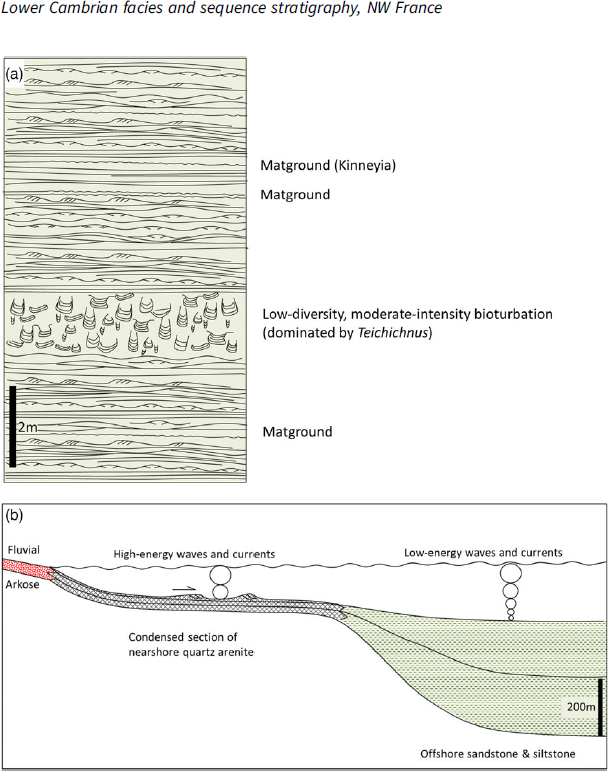
Fig. 11. (a) Offshore shallow-marine facies dominated by primary sedimentary structures with microbially induced textures on bedding surfaces and sporadic layers with intense but low diversity bioturbation, as exhibited by the Le Rozel and Carteret Formations. (b) Super-mature, coarse-grained, quartz arenite, seen at Erquy, formed as a condensed section on a shelf during marine transgression. Fines are interpreted to have been winnowed from the shelf and deposited in more basinwards localities.
The TST is thinner in marginal parts of the basin in Sequence 1 at Erquy and Bréhec (Fig. 2). Mature coarse-grained quartz arenites are developed at Erquy where they contrast strongly with the immature, arkosic fluvial strata (Figs 3e, 4g, 6). They have been interpreted as nearshore-marine deposits, and their conspicuous mineralogical and textural maturity the result of high-energy nearshore-marine processes (Went, Reference Went2013). The correlation presented in this study suggests a key extra ingredient in the sediment maturation process. It suggests a basin shelf or shoulder location transgressed and flooded by marine waters but with low rates of sediment aggradation, resulting in a thin 30 m interval of sandstone. This represents a condensed section; the equivalent section in more basinwards locations exceeds 400 m (Fig. 11b). The super-mature nature of the sandstone is considered the result of prolonged abrasion of sediment by high-energy marine processes on a shelf experiencing very low rates of sediment aggradation. Fines winnowed from the sand are inferred to have been transported offshore where they accumulated in more basinwards settings (e.g. Pont Farcy).
7. Conclusions
A sequence stratigraphic interpretation and correlation of Cambrian strata in NW France reveals two third-order stratigraphic sequences, each several hundreds of metres thick, infilling two basins that formed under a tectonic control. The stratigraphic framework is used to characterize and analyse the controls on the processes of sedimentation at the basin scale.
Thick transgressive successions at basin margin localities feature rocks deposited in fluvial and deltaic environments. Fluvial deposits are dominated by those of sheet-braided style, typical of high-peak-discharge rivers. Two contrasting styles of high-discharge, fluvially dominated delta are identified.
The first are lobate, shoal water deltas with delta-front strata consisting of wave-formed sedimentary structures overlain by the bedload deposits of multiple terminal distributary channels. Stacked parasequences of 8–10 m thickness represent repeated progradation of the delta system into a marine environment, which formed on a relatively stable, low-gradient basin floor slope. Repeated birfurcations of channels on a sandy, low-gradient delta plain resulted in an ordered dispersion and deceleration of discharge prior to flows entering the marine environment.
The second type show delta-front strata dominated by hyperpycnites, the mass flows resulting from high-discharge river floods associated with steeper delta fronts formed in deeper water. In this case there is no evidence of an ordered deceleration of discharge prior to flows entering the sea. In several cases a tectonic control on basin bathymetry is inferred, relatively steep and unstable basin floor slopes occurring in the hanging wall of syndepositionally active faults.
Fossil microbial life forms, manifest as stromatolites, wrinkle structures and Arumberia, are conspicuous and widespread in Sequence 1, as are intervals of locally high-intensity, low-diversity bioturbation in the marine strata. The evidence for the presence of mixed life forms is consistent with the punctuated replacement of algal matgrounds with mixgrounds of burrowing invertebrates in marine environments during Stages 2 and 3 of early Cambrian time.
Super-mature marine quartz arenites are locally present at basin margins where they contrast strongly with immature, arkosic fluvial strata. They are interpreted to have accumulated as condensed sections on basin shoulders where high-energy wave processes reworked sediment extensively during marine transgression under conditions of low-sediment aggradation rate.
Acknowledgements
This research received no specific grant from any funding agency, commercial or not-for-profit sectors. Grateful thanks are extended to the editor Stephen Hubbard, and to Darrel Long and an anonymous referee for their constructive critical reviews of the manuscript that resulted in numerous beneficial revisions.


