


Introduction
Uneven access to resources is often associated with the emergence of social status and its differentiation, stimulating and crystallising inequality (Brumfiel Reference Brumfiel1992; Lohse & Valdez Jr Reference Lohse and Valdez2004; Price & Feinman Reference Price and Feinman2010). The rise of social hierarchies and associated power strategies established and sustained inequality as a permanent, malleable human state. Those with access to resources and power are often labelled ‘elites’, and those without are labelled lower class or ‘commoners’. Consequently, archaeologists widely assume that monumental architecture and prestige goods bestow greater archaeological prominence on elites, making the identification and study of commoners challenging (Marcus Reference Marcus2004). Researchers in some regions, such as Europe and Latin America, have theorised elite-commoner relations in more depth, and have attempted—with some success—to identify lower classes in the archaeological record (e.g. Gonlin & Lohse Reference Gonlin and Lohse2007). To date, however, there has been little interest in past social inequality from archaeologists working on Southern Africa, and indicators of inequality at major centres of power, such as Great Zimbabwe (AD 1000–1700) (Figure 1), have long been poorly understood.

Figure 1 Map of Great Zimbabwe showing different components such as the intra- (black outlines) and extramural areas (grey colour).
Previous work at Great Zimbabwe has established a five-period occupation sequence: period I (AD 300–900) was followed, after a clear stratigraphic break, by periods II (AD 900–1000) and III (AD 1000–1200), which represent the formative stages of Great Zimbabwe. By period IV (AD 1200–1700), the site had achieved its most developed form as an urban centre and state capital; period V covers the period after AD 1700 (Summers et al. Reference Summers, Robinson and Whitty1961; Chirikure et al. Reference Chirikure, Pollard, Manyanga and Bandama2013). The site’s monumental dry stone-walled enclosures, constructed in periods III and IV, are surrounded by unwalled, extra-mural settlements. To date, archaeologists have associated the walled areas with a hereditary noble class (elites), conceptually and physically separated from the commoners by an outer perimeter wall running from the north-west of the Hill Complex to the south-west of the Great Enclosure (Huffman Reference Huffman1996) (Figure 1). This interpretation is based partly on an old type of Childean thinking (Childe Reference Childe1950), which associates elites with monumental architecture and ‘prestige goods’ such as glass beads, Islamic ceramics, Chinese porcelain and objects of gold, bronze and soapstone, amongst others (Huffman Reference Huffman1996). Site looting and poor documentation of early excavations, however, confound statistical comparisons of the relative frequency of prestige goods and status symbols in areas traditionally classified as ‘elite’ or ‘common’.
The validity of a simple dichotomy of elites within and commoners outside the walls of Great Zimbabwe, however, relies on two significant archaeological assumptions. The first is that the walled (intramural) and unwalled (extramural) areas were occupied simultaneously. The second is that the types of material culture used within and outside the perimeter wall demonstrate differences based on social inequality. Using evidence from archival collections, supplemented with data from new survey and excavation in the extramural areas (Figure 1), we reassess the question of inequality at Great Zimbabwe. Combined with comparative insights from Shona anthropology and linguistics, this reconsideration indicates that the perimeter wall represents neither the symbolic nor the physical separation of elites from commoners. Rather, the patterning of material culture, embedded materialities and chronological differences between areas suggest that homesteads shifted through time, complicating the identification of inequality and class.
Theoretical and methodological approach
Shona anthropology and linguistics
Comparative insight into the organisation of social power in this region comes from Shona anthropology, history and linguistics. Great Zimbabwe was an urban centre (guta) (Garlake Reference Garlake1973). The guta (plural: maguta) had three overlapping definitions: urban centre, large village and chief’s village (Hannan Reference Hannan1994: 204; Chimhundu & Mangoya Reference Chimhundu and Mangoya2001). Maguta were multi-settlement places that became mizinda (singular: muzinda), or centres of power, when someone became chief. As a collection of homesteads, the guta had no formalised bureaucracy, division of labour or occupational specialisations (Chirikure et al. Reference Chirikure, Bandama, House, Moffett, Mukwende and Pollard2016). Although there were differences in social status within maguta, often these were not rigidly defined as ‘elite vs commoner’. Advisers (makurukota) and specialists (nyanzvi) often resided in separate homesteads that were located away from the chief’s muzinda. Services were offered individually and collectively, as and when the need arose, in a dispersed network of reciprocal collective action. Power was dispersed among people who lived in different places (the chief in the muzinda, and advisers and specialists in their own homesteads), rather than a single place (Chakaipa Reference Chakaipa1976). Thus, the system of social power was dispersed, rather than concentrated. Within mizinda, the chiefs or kings often lived with their immediate families and servants (Beach Reference Beach1998).
Power rotated between the elders in a lineage (imba yeushe). Often, the succession of a new chief did not place them into their predecessor’s muzinda. Rather, their own homestead became the new political centre (muzinda) (Sinclair et al. Reference Sinclair, Pikirayi, Pwiti and Soper1993; Chirikure et al. Reference Chirikure, Manyanga and Pollard2012). Political formations were often a mixture of people from different lineages. The ruling lineage was defined by descent, with those from the ruling lineage often forming a social category distinct from that of those outside the lineage, who were political commoners (singular: muranda; plural: varanda) (Chimhundu & Mangoya Reference Chimhundu and Mangoya2001). Specialists, such as hunters (vavhimi), smelters and smiths (mhizha), farmers (hurudza) and traditional healers (n’anga), operated independently in their own homesteads. Often, these specialists could be from the ruling lineage or outside of it, and used their coveted skills and knowledge to accumulate wealth (Gombe Reference Gombe1986). While political office was accessed only through lineage, anyone could become a specialist and amass wealth (upfumi). Thus, regardless of lineage, one could be either rich (kupfuma) or poor (kuva murombo), as reflected in the Shona proverb kupfuma ishungu (‘being wealthy is all about hard work’). Following from this, commoners often shared the same material culture as elites, using wealth accumulated through their skills and specialisms. Material culture was not the primary means through which political status was achieved and sustained. Kings could be materially poor, while commoners could be materially rich and vice versa. Although the material culture might have been identical, its meaning, however, differed according to political status. Thus, although a king’s spear was often similar to that of a commoner, political office conferred symbolic significance upon it (Chirikure et al. Reference Chirikure, Bandama, House, Moffett, Mukwende and Pollard2016; Moffett & Chirikure Reference Moffett and Chirikure2016). This situation makes it difficult archaeologically to distinguish social inequalities based on the distribution of material culture, even where good spatial and chronological control is available.
As maguta were made of multi-homesteads that were sometimes spatially dispersed, individual households practised multiple crafts and subsistence activities—such as metallurgy, weaving and hunting—to achieve self-sufficiency. Even kings could also be hunters or metalworkers, for example (Chakaipa Reference Chakaipa1976). Hence, the political and economic elite were not necessarily synonymous. There are also many other relationships beyond birth or lineage that are critical for understanding class. For example, as one was forbidden to marry within one’s own lineage, marriage created the opportunity for class mobility. A married king was bound to in-laws, uncles and nephews, and was required to abide by rules or conduct consistent with any given relationship. Upon death, the wealth and possessions of individuals were redistributed to relatives through an inheritance system (kugara nhaka). Wealth accumulation from previous generations or leaders was therefore minimal. This practice is reflected elsewhere in the world: Incan rulers, for example, had to accumulate their own wealth and land; at Copa in Honduras, Maya elites and commoners shared material culture regardless of the size or location of their houses (Gonlin & Lohse Reference Gonlin and Lohse2007). De Maret (Reference De Maret1999) has observed similar cultural practices in Central Africa (see also McIntosh Reference McIntosh1999).
The Shona philosophy, practice and ethnography discussed above raises the possibility of rich commoners and poor kings, and therefore cautions against the assumption that archaeologically conspicuous materials indicate elites. Instead, the categories of elite and commoner were situational and transient. In turn, this requires a more robust theorisation than the old Childean approach that still shapes understanding of Great Zimbabwe. In fact, it may be better to use the terms elite and commoner purely heuristically, moderated by any given cultural context (Gonlin & Lohse Reference Gonlin and Lohse2007).
Archival studies
Most objects from the walled area at Great Zimbabwe are relatively well documented. These include gold ornaments, soapstone birds and bowls, iron gongs, crucibles and ingot moulds (e.g. Caton-Thompson Reference Caton-Thompson1931; Summers et al. Reference Summers, Robinson and Whitty1961; Garlake Reference Garlake1973; Chirikure & Pikirayi Reference Chirikure and Pikirayi2008). Much less is known, however, about those objects from the extramural areas, the limited excavation of which remains largely unpublished. This discrepancy prompted our analysis of unpublished archival materials housed at the Great Zimbabwe Conservation Centre. Excavations in the late 1980s examined the Barrier Hut, in the extramural area, near the former National Parks Office (Figure 1). The floor plan of the Barrier Hut as well as other houses in the western area (Figure 2) and in the extramural settlement near the Curio Shop (Huffman Reference Huffman2007: 398) resemble the architectural form of house floors within the walled areas, such as the Maund Ruins (Caton-Thompson Reference Caton-Thompson1931). The only difference between the architecture in extra- and intramural areas is that, in the former, the connecting walls between huts are constructed with dhaka (adobe/clay), and, in the latter, they are built with dry stone (Figure 2). The lack of excavation notes and records in the archive preclude a stratigraphic and chronological analysis of the objects. The Barrier Hut, however, yielded evidence of local pottery (mostly period IV) and gold and bronze items. Miller (Reference Miller2002) associates gold and bronze only with elites at Great Zimbabwe.
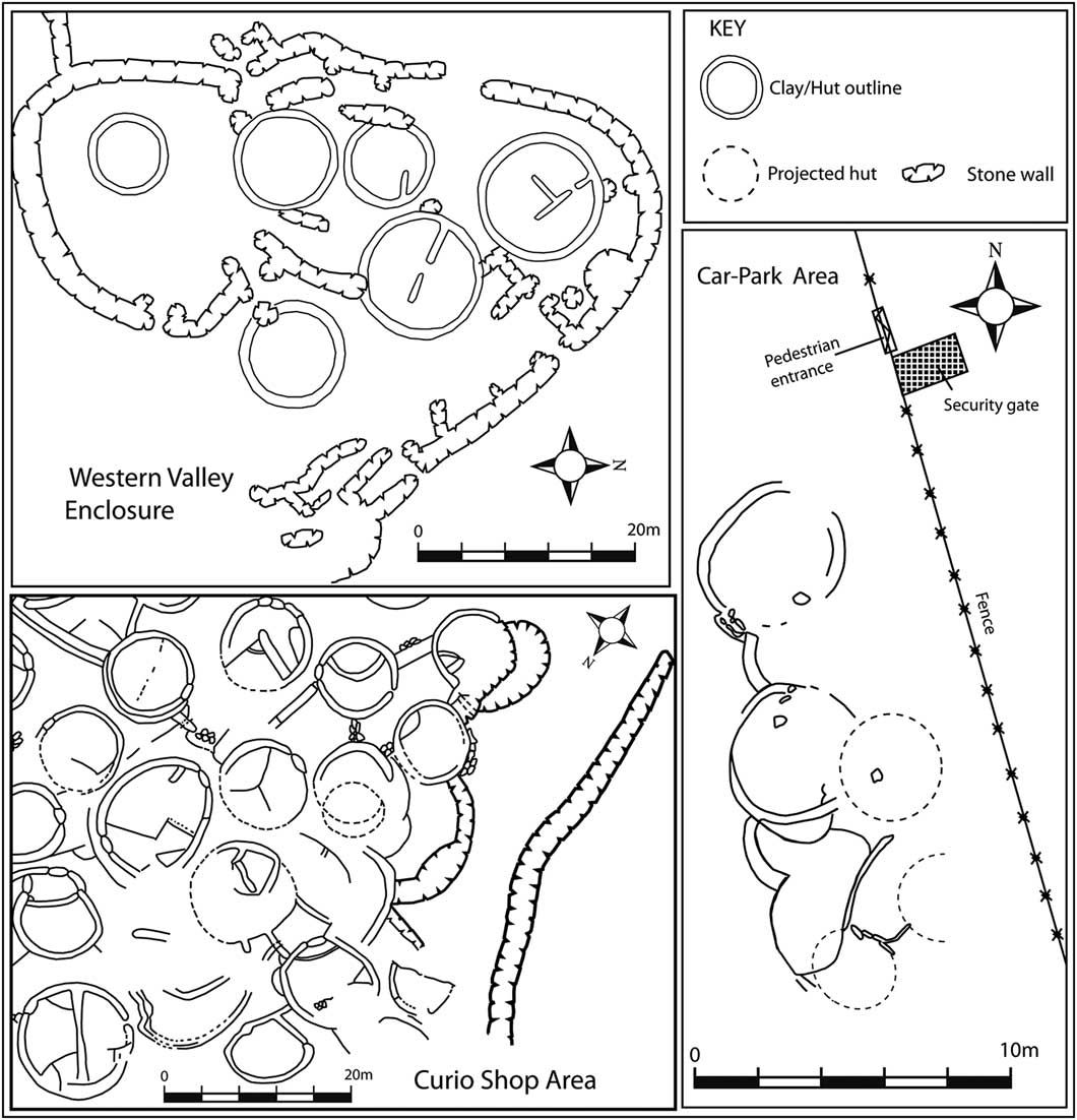
Figure 2 Floor plan of houses in the Western Valley Enclosures (intramural area) and the Car Park midden and Curio Shop areas (extramural) (adapted from Collet et al. 1992; Huffman Reference Huffman2007; and authors’ own fieldwork).
Huffman and colleagues excavated the unwalled area near the Camp Ruin, inside the outer perimeter wall (Figure 1), where they found local pottery (period IV), a coin with an Arabic inscription, bronze objects, tin ingots, copper and iron objects, and faunal remains (Huffman & Vogel Reference Huffman and Vogel1991; Miller Reference Miller2002; Huffman Reference Huffman2007). The stratigraphy and most of the finds are unpublished, and no excavation report was found in the Archaeological Survey of the Zimbabwe Museum of Human Sciences (Survey File 2030BD1). A set of radiocarbon dates, however, suggest late fourteenth- to mid seventeenth-century AD occupation (Huffman & Vogel Reference Huffman and Vogel1991: 66–68). The incompleteness of the archives for the unwalled areas necessitated new excavations at promising locations. Six middens were targeted: one in the current Car Park and another close to the Barrier Hut; a third located about 180m east of the rear of the Great Enclosure, on a modern-day fireguard (a thin stretch of gravel that is maintained to act as a firebreak), and two located approximately 300m north-east of the East Ruin, in an area known as Mujejeje.
The Car Park midden and Barrier Hut excavations
The eastern side of an eroding midden situated in the site’s car park was excavated with a 3 ×1m trench (Figure 3). The midden is flanked by a cluster of house foundations with thick dhaka walls. The trench was excavated to a maximum depth of just over 0.7m. The original height of the midden was unclear due to erosion. Two AMS dates on burnt bone indicate activity between AD 1450 and 1660 (Beta-396347 & Beta-396345; OxCal v4.3.2 at 95.4% confidence, using the southern hemisphere calibration curve SHCal13; Bronk Ramsey Reference Bronk Ramsey2009; Hogg et al. Reference Hogg, Hua, Blackwell, Niu, Buck, Guilderson and Zimmerman2013) (Figure 3). The excavation yielded many artefacts, including local pottery, glass beads, crucible fragments, bronze decorative items and ostrich eggshell beads.

Figure 3 Section of the Car Park midden and the excavation sections for trench 1.
To obtain dates for the previously excavated Barrier Hut, a 2×1m trench was excavated next to the now-buried structure (i.e. back-filled following the previous excavation). Approximately 0.1m below the surface, we encountered a thick dhaka wall (Figure 4). Excavation proceeded around the wall and reached sterile ground at a depth of 0.6m depth. Period IV pottery, faunal remains and glass beads were recovered. A charcoal sample from layer 2 produced an age range between cal AD 1519 and 1653 (OxCal v4.3.2 at 95.4% probability, SHCal13; Beta 447 828 (310±30 BP) (Figure 4).

Figure 4 Plan and section drawing of the Barrier Hut excavation.
Fireguard midden 1 excavation
Another excavation was undertaken on a low midden in the fireguard area, with a 2 ×2m trench (Fireguard midden 1, trench 1), which reached a maximum depth of 0.6m (Figure 5). It was assumed that this area would yield material dating to occupation Period V (see Sinclair et al. Reference Sinclair, Pikirayi, Pwiti and Soper1993). The dense vegetation canopy made it unclear whether there were any houses between the midden and the back of the Great Enclosure, although there were house floors and low stone-walled enclosures approximately 50m north of the midden. The trench yielded local Period IV pottery, two gold beads, glass beads, faunal material and more than 50 fragments of crucibles with gold droplets within the adhering slag. Charcoal from layer 1 produced an age estimate between cal AD 1446 and 1463 (95.4% probability, SHCal13) (Beta 447 827: 460±30 BP).

Figure 5 Fireguard midden 1 plan and excavation section.
Excavations of the Mujejeje middens
To obtain sufficient comparative data from another extramural area, excavations were undertaken at two further locations (Figure 1) near Mujejeje, on the eastern side of Great Zimbabwe. Here, erosion had exposed house floors similar in style to those in the Car Park and walled areas of the site. Three trenches were opened. The first sampled the edge of a recent borrow pit, whose excavation had exposed floors in its cross section; the second and third were situated adjacent to a cluster of houses to the east and north of the first trench. Overall, no trench exceeded 0.6m in depth (Figure 6). All excavated trenches yielded metal objects, period IV local pottery and faunal remains. Three radiocarbon dates were obtained (all calibrated using OxCal v4.3.2 at 95.4% probability, SHCal13): layer 2 of Mujejeje midden 1, trench 1 (Beta 447 825: 430±30 BP; cal AD 1452–1496), layer 1 of Mujejeje midden 2, trench 1 (Beta 447 832: 530±30 BP; cal AD 1420–1442) and layer 4 of trench 3, midden 3 (Beta 447 833: 500±30 BP; cal AD 1435–1451).
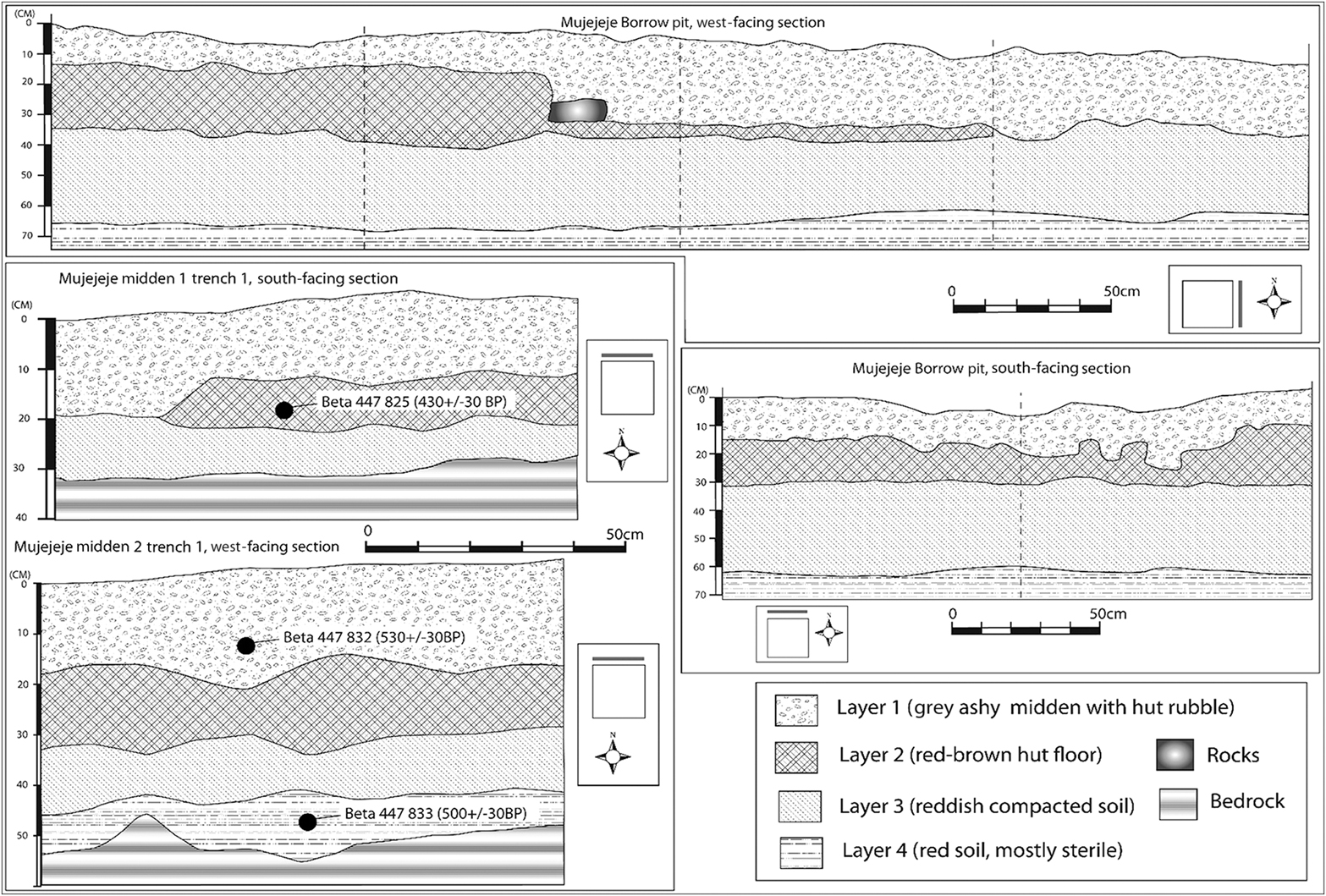
Figure 6 Section drawings of the Mujejeje excavations.
Analyses of excavated materials
The excavations within the extramural areas produced local pottery, imported glass beads, ostrich eggshell beads, metal objects, crucibles, slag and faunal remains. These were analysed in the laboratory using standard techniques. Dated samples estimated the duration of occupation in these extramural areas to be between the mid fifteenth and the mid seventeenth centuries AD.
Local pottery from the extramural excavations
Pottery from the excavations was typologised using the standard multivariate procedure employed in Southern Africa (Robinson Reference Robinson1961a; Pikirayi Reference Pikirayi1993; Chirikure et al. Reference Chirikure, Pikirayi and Pwiti2002; Huffman Reference Huffman2007). A total of 7069 pottery sherds were recovered from the following: Barrier Hut midden 1, trench 1; Car Park midden 1, trench 1; Fireguard Upper Ridge midden 1, trench 1; Mujejeje midden 1, trench 1; and Mujejeje midden 2, trench 1. Of these sherds, 504 (7.2 per cent) are typologically diagnostic (Table 1). Diagnostic pots were photographed and classified into 10 vessel shapes: tall-necked pots with flared rims (4a); short-necked pots with thickened rolled and beaded rims (4b); shouldered pots with thickened rims (4c); shouldered pots with simple rims (4d); neckless pots with thickened rims (4e); neckless pots with simple rims (4f); constricted pots with thickened rims (4g); constricted pots with simple rims (4h); deep bowls (4i); and hemispherical bowls (4j). Figure 7 shows vessels belonging to period IV. The assemblage is dominated by necked pots (4a–c). The most frequent vessel shapes are 4b (57 per cent; n=189) and 4c (16 per cent; n=53). These are followed by type 4a (9.1 per cent; n=30), 4e (4.2 per cent; n=14) and 4f (2.1 per cent; n=7). The remainder of the assemblage comprises types 4g, 4i and 4h.

Figure 7 Examples of period IV pottery from the excavated extramural areas.
Table 1 Classification of excavated pottery from Great Zimbabwe unwalled areas.

Decorated pottery is rare (only 20 of the 504 diagnostic sherds), but when present, the incised patterns are lavishly burnished with graphite (Robinson Reference Robinson1961a: 204–205). The four incised decorative motifs, appearing on vessel rims, necks and shoulders, are: interlocking triangles (45 per cent; n=9); horizontal bands of either fine or broad oblique lines (40 per cent; n=8); and cross-hatching (15 per cent; n=3) (Table 1). No period V pottery was recovered, an observation supported by the radiocarbon dating of the extramural areas.
Imported glass beads
A preliminary study of the glass beads shows variation in frequency between the excavated middens. One hundred and five glass beads were recovered from Fireguard midden 1, trench 1. The Barrier Hut excavation yielded a single bead, and the Mujejeje middens none. The glass beads were classified and analysed using procedures adapted from Bvocho (Reference Bvocho2005) and Wood (Reference Wood2005), to build typologies based on a combination of variables, such as methods of manufacture, materials, shape, transparency and colour. The established classes matched the Mapungubwe, Great Zimbabwe and Khami series of glass beads (Pikirayi Reference Pikirayi1993; Robertshaw et al. Reference Robertshaw, Wood, Melchiorre, Popelka-Filcoff and Glascock2010; Koleini et al. Reference Koleini, Pikirayi and Colomban2017), although further analyses are ongoing.
Metal objects and metalworking
Various materials associated with metal production (e.g. nodules of slag, finished iron artefacts and cuprous objects) were recovered from all excavated areas. The iron objects are mostly utilitarian, including broken hoes, axes, arrowheads, possible spearheads and chisels. Qualitative metal analysis using a Niton XLT Portable XRF analyser has revealed the presence of pure copper and low tin-bronze (tin ranges from 4–8 wt. %) objects. The Fireguard midden 1 excavation produced two gold beads, while the Barrier Hut excavation yielded a crucible with gold globules trapped in the slag that adhered to the crucible wall.
The excavations recovered different types of crucibles ranging from recycled normal pottery to custom-made, small specialised types, the latter coming from the Fireguard midden 1 excavation (Figure 8). These comprised a mix of complete crucibles and moulds, most of which have globules set in the slag. Crucibles were also recovered from the Car Park midden and Barrier Hut areas. Analysis so far shows that copper, bronze and gold were processed in pottery and specialised crucibles in homesteads associated with these extramural areas.

Figure 8 Specialised gold-melting crucibles from the Fireguard midden 1 trench 1.
Faunal remains
The faunal remains were cleaned in the Archaeology Laboratory at the Great Zimbabwe Conservation Centre, and are currently under analysis. Preliminary identifications suggest the presence of both domestic and wild animals, with cattle (Bos taurus), goat/sheep (Ovis capra), rock rabbit/dassie (Procavia capensis) and wildebeest (Connochaetes) as the most commonly represented species. Most of the domestic cattle epiphyses are unfused, suggesting that they were slaughtered in youth (Klein & Cruz-Uribe Reference Klein and Cruz-Uribe1984).
Discussion
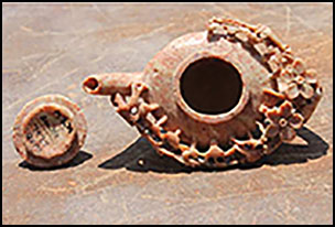
The chronological and spatial evidence presented here suggest that the conventional partitioning of Great Zimbabwe into intramural/elite and extramural/commoner areas may be an archaeological construct profoundly at variance with how its inhabitants understood their guta. Archaeologists have often linked prominent objects (e.g. a Chinese jade teapot, Figure 9) from the intramural areas, with the presence of the elite. Often, these ‘high-status’ objects and symbols are stratigraphically associated with local pottery, slag, crucibles, spindle whorls, iron objects, faunal remains and other traces of technological and domestic practices (Garlake Reference Garlake1973). Fragmentary documentation confounds any quantitative analysis of variation in artefact frequency, and the near-uniform distribution of material culture and status symbols within the walled enclosures suggest multi-crafting and self-sufficiency on the part of the individual homesteads (Chirikure & Pikirayi Reference Chirikure and Pikirayi2008).

Figure 9 Chinese jade teapot recovered from the Renders Ruin at Great Zimbabwe (source: S. Chirikure).
Excavations on the western, eastern and south-eastern areas of the extramural settlements (Figure 1) yielded glass beads, slag, bronze- and gold-processing crucibles, gold beads, bronze ornamental objects, iron spearheads and arrowheads, spindle whorls, faunal remains and locally made pottery. The gold-processing crucibles from Fireguard midden 1, trench 1 provide clear evidence for gold-working in the extramural settlements, corroborating Collett’s unpublished discovery of similar materials from excavation of the Barrier Hut. Miller’s (Reference Miller2002) analysis of metal objects from Huffman’s excavations near the Camp Ruins identified tin ingots, as well as bronze, iron and copper objects. The local pottery from all the extramural areas is unequivocally period IV, and cannot be differentiated stylistically from that found within the walls (see Robinson Reference Robinson1961b).
What, therefore, are the major similarities and differences in the distributions of material culture within and outside the perimeter walls of Great Zimbabwe? ‘High-status’ materials, such as glass beads, gold objects, gold-processing crucibles, bronze objects and spindle whorls, have been recovered from both areas. Evidence of craft production across the site indicates self-sufficiency at the household level. Furthermore, the period IV pottery is the same in both areas, and glass beads (e.g. Khami beads) from contemporaneously occupied areas of the site are stylistically identical. The architectural style and plan of houses in both intra- and extramural areas are also indistinguishable. Lastly, young animals dominate the faunal assemblage from the extramural areas. This reflects the slaughter pattern identified through cattle bone from the Hill Complex, within the perimeter walls. This is significant, as Thorp (Reference Thorp1995) has argued that the Great Zimbabwe elites subsisted on beef from young animals, although her conclusions appear to be based on a small and unrepresentative faunal sample from the intramural areas.
The most obvious difference, however, is that dry stone walls and imported ceramics are absent in the extramural areas. Furthermore, high-status soapstone artefacts are so far known only from within the perimeter walls. The distribution of soapstone is temporally and spatially restricted and appears to follow that of the walls. That no soapstone has yet been recovered from the extramural areas, however, may reflect the absence of comprehensive research in these areas.
To comprehend fully the significance of these similarities and differences, it is essential to consider their chronology. It is generally believed that construction of dry stone wall enclosures began on the hill around AD 1000 and spread to the area inside the Great Enclosure with period III deposits (Summers et al. Reference Summers, Robinson and Whitty1961; Chipunza Reference Chipunza1994). Thereafter, walling spread to the Valley Enclosures in period IV, while areas with earlier walls were extended with new wall types (Whitty Reference Whitty1961). The few available radiocarbon dates from Great Zimbabwe’s intra and extramural areas present a chronological challenge. The final phase of occupation of the major areas of the site, such as the Hill Complex and the Great Enclosure, may have been in the early sixteenth century (Chirikure et al. Reference Chirikure, Pollard, Manyanga and Bandama2013). Huffman and Vogel (Reference Huffman and Vogel1991) and Garlake (Reference Garlake1973), however, suggest that the Hill Complex was abandoned around AD 1450, while Collett et al. (Reference Collett, Vines and Hughes1992) argue that the presence of blue-on-white porcelain demonstrates occupation of the Valley Enclosures well into the mid sixteenth century. Radiocarbon dates from our own excavations outside of the walls suggest that settlement in parts of the western, eastern and south-eastern areas of the site continued into the seventeenth century—an observation further supported by the presence of Khami beads in the same areas.
This chronology suggests that while occupation at Great Zimbabwe ebbed and flowed over time—sometimes resulting in re-occupation of areas (Summers et al. Reference Summers, Robinson and Whitty1961; Sinclair et al. Reference Sinclair, Pikirayi, Pwiti and Soper1993; Chirikure et al. Reference Chirikure, Bandama, Chipunza, Mahachi, Matenga, Mupira and Ndoro2017)—there was a shift from stone-wall construction to the use of dhaka walls in extramural areas. Nonetheless, the house plans remained consistently similar to those within the intramural areas (Figure 2). It is possible, therefore, that while dry stone wall construction declined and perhaps ceased, the continuing occupation in later areas retained earlier architectural principles. This expansion and contraction challenges the division of Great Zimbabwe into commoner and elite zones based on which side of the perimeter wall they were located.
Here, it is essential to consider the comparative and theoretical insights from Shona philosophy (above) and their implications for identifying commoner and elite residences. Acknowledging that different areas of Great Zimbabwe date to different periods, it is important to note that large Shona settlements—maguta—expanded and contracted over time with successive generations. Usually, such individual maguta were occupied by people of shared lineage and had equal access to resources, symbols and power. Comparatively, the archaeological expectation is that each guta must be associated with more or less the same types of material representing different activities. Beach (Reference Beach1998) posits that Great Zimbabwe comprised various settlements that housed different leaders over time, following a typical Shona system of rotational succession. Not surprisingly, the distribution of material culture in the enclosures shows that chronologically overlapping areas of the site are associated with identical material culture representing craft activities, prestige objects, symbols (such as spearheads) and domestic practices (Chirikure & Pikirayi Reference Chirikure and Pikirayi2008). Indeed, other than the absence of house-connecting dry stone walls, the so-called ‘elite’ objects are also found in extramural areas. This demonstrates convergence between patterns in the archaeology and the Shona historical and anthropological records. Feinman and Nicholas (Reference Feinman and Nicholas2012) have shown that production in pre-Columbian state and urban systems in Mesoamerica was household-based.
Kings and members of their lineages also participated in mundane and technical activities, such as hunting, farming and metalworking. Hence, Great Zimbabwe has no demonstrable evidence for division of labour or occupational specialisation, with dedicated spaces for metalworkers, weavers, stone masons, priests and so on in different parts of the settlement. Stahl (Reference Stahl2004) has demonstrated that the political economy of many East and West African capitals and state systems comprised a mosaic of different activities that included different technical, ritual, mundane and ecological knowledge. Class was therefore very fluid, incorporating not just economic, but also political and other variables. Such a model obviously contradicts expected outcomes based on archaeological analyses that use old Childean traits to examine class and inequality in early urban centres (see McIntosh Reference McIntosh1999).
A critical observation is that social and political elites often lived with servants (vashandi) and slaves (nhapwa) in their homesteads (Beach Reference Beach1998). The majority of commoners (varanda or mangoya) lived in their own homesteads away from the centre. In the late nineteenth century, for example, Chief Mugabe was resident in the Hill Complex at Great Zimbabwe, but his subjects and political advisors lived away in their own homesteads (Bent Reference Bent1896). At the centre, material culture was shared, making it hard to differentiate elites and commoners. Hall (Reference Hall2000), for example, failed to identify material proxies of slaves who lived with their masters during the rule of the Dutch East India Company in Cape Town from the seventeenth century onwards; in the elite homesteads, slaves often used material culture similar to that of their masters—making them archaeologically indistinguishable. Use of and access to material culture is therefore distinct from ownership of such material culture. In the absence of documentary records, however, it is difficult to prove ownership. As Great Zimbabwe comprises a constellation of elite homesteads that most probably rotated power between themselves, the bulk of the population encompassed members of the ruling lineages. The expectation is that most of the commoners who were not servants (varanda or mangoya) lived outside, in their own homesteads, which networked with the centre in a dispersed system. The idea that Great Zimbabwe’s spatial geography can therefore be neatly divided into two zones occupied by elites (intramural areas) and commoners (extramural areas) becomes untenable.
Finally, more work is required to define elites and commoners, and their archaeological correlates. Elites could be economic, political and social. Specialists (nyanzvi), by virtue of access to technical, ritual or ecological knowledge, could become economic but not political elites. Based on their lineage, political elites had access to symbols of power and status that, in some cases, were similar to those used by ordinary people. Context and ownership often afforded high status to objects possessed and owned by kings, even if they looked mundane. Admittedly, it is archaeologically challenging to identify commoners and elites given this entangled, heterogeneous and ever changing situation. Nevertheless, this forces archaeologists to be alert to situational subtleties that enrich temporal and spatial cross-cultural comparisons of human behaviour.
Conclusion
Excavations in several extramural areas of Great Zimbabwe have yielded glass beads and gold and bronze objects, as well as associated production infrastructure, such as crucibles. All of these are traditionally associated with elites at the site. Furthermore, the layout of houses in extramural areas resembles that of the walled areas, the only difference being that dry stone walls are absent in the former. It appears that there was a shift from dry stone wall construction to building homesteads without dry stone enclosures from the mid sixteenth century onwards. This brings the chronology of different areas into focus: based on current dating evidence, most extramural areas appear to represent the final settlements to be abandoned at Great Zimbabwe.
Such reasoning encourages further work at settlements outside Great Zimbabwe, where most commoners were probably based. While Great Zimbabwe was occupied by both elites and commoners, servants, most probably, lived with the ruling lineages and did not have their own distinct residential quarters. More research is required to refine our understanding of class and inequality at Great Zimbabwe, but it is clear that ‘elites’ and ‘commoners’ within this centre of power should not be oversimplified; they demonstrate complex temporal, spatial and material relationships.


