


Introduction
The systematic study of stonemasons’ marks used in past construction projects started in 1979 with the first of an ongoing series of colloquia of the Centre International de Recherches Glyptographiques. These and comparable studies have resulted in inventories and classifications of stonemasons’ marks and their uses in buildings archaeology, mostly for (post-)medieval masonry but also for ancient Mediterranean constructions (Van Belle, Reference Van Belle and Van Belle1983; Doperé, Reference Doperé and Van Belle1997; Doperé & Van Belle, Reference Doperé, Van Belle and Nobletforthcoming). Recent contributions include work on building and restoration in ancient Greece and Asia Minor (Weber, Reference Weber2013, Reference Weber and Moretti2014, Reference Weber, Broeck-Parant and Ismaelli2021), on the Old and Middle Kingdom in Egypt, as well as on neo-Hittite, Hellenistic, Roman, Nabatean sites, and crusader fortifications (Bessac, Reference Bessac and Medina2015). Furthermore, von Kienlin (Reference von Kienlin, Kurapkat and Wulf-Rheidt2017) has discussed the origins of numerical stonemasons’ marks as timber marks in the sixth century bc in Asia Minor.
Among the different types of stonemasons’ marks, one group consists of paired identical marks, i.e. one on each side of a joint. These can be interpreted as paired course identification marks, as assembly marks, or as paired placement marks. Paired course identification marks indicate stones with the same height destined to form one specific course. Assembly marks designate two stones to be placed next to each other. Paired placement marks refer to two stones to be placed one on top of the other. In addition, many stonemasons’ marks displaying more random patterns have been documented, though their function usually remains enigmatic and their potential within archaeology untapped. The present study, which examines the relations between such marks and their associated structural elements in four case studies at Sagalassos in south-western Turkey, revealed another purpose: to denote batches of building or paving elements, indicating who carried out the work to ensure due payment. In this article, we detail how we reached this conclusion, by describing 1) how we identified marks and differentiated between them; 2) determined whether the marks were in situ; and 3) conducted a spatial analysis of the marks and interpreted it. Because the stonemasons’ marks were carved by labourers and/or contractors, and the case studies allow a diachronic examination, the results can throw light on developments in labour-related and social aspects of these building and paving processes.
Setting and Aims
Sagalassos, situated in the Taurus mountains of south-western Turkey, was an active settlement from Late Achaemenid to Middle Byzantine times (fifth century bc to thirteenth century ad). For more than thirty years, this site is being investigated by the Sagalassos Archaeological Research Project of the KU Leuven in Belgium. The material evidence discussed here dates to Roman Imperial times (first–third century ad). While there is no direct way of dating marks punched or chiselled into building or paving blocks, we assume that stonemasons’ marks lose their active role once construction or paving was concluded. Consequently, their terminus post and ante quem are defined by the beginning and conclusion of the building or paving process. This requires establishing that the mark-bearing blocks remained in situ.
At Sagalassos, stonemasons’ marks have been documented since the 1990s. Except for assembly marks, their spatial distribution appears quite random. In part, this has been attributed to differential preservation (Loots, Reference Loots2001: 54–64). An in-depth analysis of these marks, especially those on paving, in combination with a study of stone carving techniques could offer a more nuanced solution. The potential synergy between stonemasons’ marks and stone carving techniques is assumed, based on their shared origin at the hand(s) of an individual or group. In addition, advances in digital technologies allow for 3D-reconstruction and digital manipulation to identify eroded marks. Our first aim in the present study was to explain the seemingly random appearance of stonemasons’ marks on only a few building or paving blocks. Since those responsible for carving the stonemasons’ marks were part of the construction or paving process (including carving the blocks), our second aim was to use these results to discuss the social and logistical aspects of local building and paving activities, offering us a glimpse beyond those who commissioned the buildings: the men at work.
Methodology
Our methodology consists of the spatial analysis of the stonemasons’ marks and a study of the stone carving techniques of building or paving blocks. During interpretation, these independent datasets were combined to exploit their potential synergy.
The stonemasons’ marks that had already been documented were (re)inspected. Based on preservation, we selected four case studies: the paving of the Upper and Lower Agora, the construction of the Hadrianic Nymphaeum, and the construction and paving of the Makellon (Figure 1). To facilitate the spatial analyses, georeferenced 3D-models were generated, from which high-resolution orthographic projections were exported. Partially overlapping high-quality images, obtained with a remote-controlled Nikon D5300 camera mounted on a 3 m-pole, were used to create these models in photogrammetry software (Agisoft Metashape). The resulting images permit the extremely detailed examination of individual paving and building blocks, including manipulation in Adobe Photoshop.

Figure 1. Sagalassos and the main buildings featured in this study.
The stone carving techniques were documented according to the basic principles and methods of stone carving analysis (Doperé, Reference Doperé2018). The wear and tear caused by the frequent usage of stone paving limits opportunities to study stone carving techniques. Therefore, the results of the stone carving analysis pertain to the upstanding elements of the Hadrianic Nymphaeum and Makellon. These analyses divide the structures into architectural components. For each element, the types of traces were analysed, and the corresponding tools determined. In the case of toothed tools, the number of teeth was established, including the width of the cutting edge. If present, the drafted margin was described, and the tool identified. The analysis of the entablature blocks had already been undertaken for the Hadrianic Nymphaeum (Waelkens et al., Reference Waelkens, Üner, Richard, Kurapkat and Wulf-Rheidt2017) and has been incorporated in our discussion.
The Paving of the Upper Agora
The paving of the Upper Agora of Sagalassos (Figure 2) took place during the second quarter of the first century ad (Talloen & Poblome, Reference Talloen and Poblome2016: 132–34). The orientation of the limestone slabs suggests that this was not a uniform process. Most of the stonemasons’ marks are present in the western section, so our study will be limited to this area. Here, the slabs were placed according to the baseline of the western portico, which was oriented according to the delineation of the square by four early first-century ad honorific columns (Vandeput, Reference Vandeput1997: 46–49; Talloen & Poblome, Reference Talloen and Poblome2016: 123–24). Because of later modifications around the north-western and south-western honorific columns, including the construction of the late second-century ad Antonine Nymphaeum (Vandeput, Reference Vandeput1997: 100–05; Waelkens et al., Reference Waelkens, Vermeersch, Paulissen, Owens, Burcu, Martens, Talloen, Waelkens and Poblome1997: 150–51, fig. 2), it is impossible to establish whether the paving was initiated from the north or the south, or both.
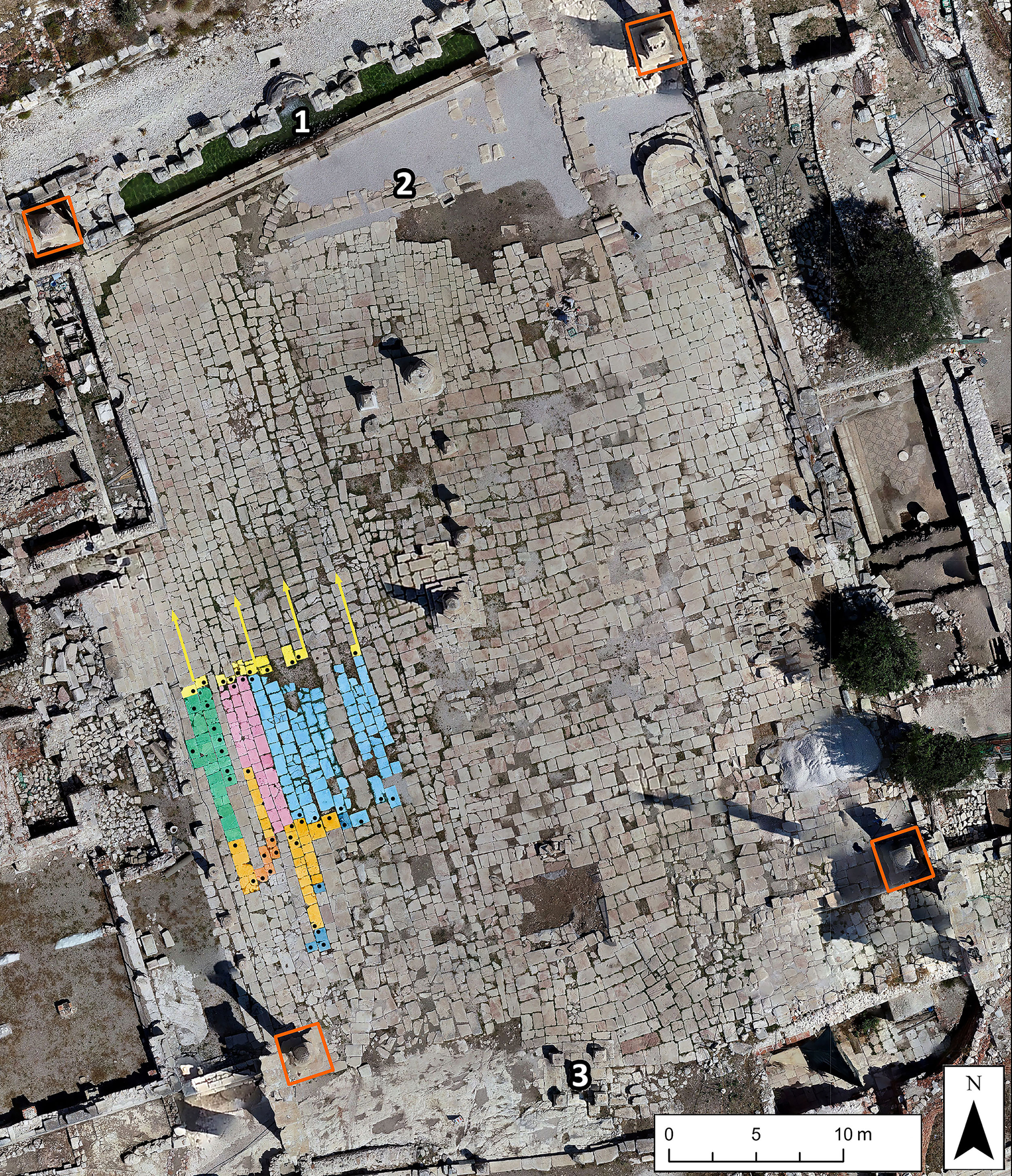
Figure 2. Orthographic image of the Upper Agora. 1) Antonine Nymphaeum; 2) Early Roman Imperial Fountain; 3) Tychaion. Orange rectangles: the four honorific columns. The batches delineated by stonemasons’ marks are shown (highlighted slabs). The direction of batches related to Z-shaped marks (yellow) is indicated by arrows. The west-east patterns of Z-shaped (yellow), π-shaped (light blue), ρ-shaped (pink), and C-shaped marks (light orange) show placed batches. The black dots indicate identified marks.
The stonemasons’ marks of the Upper Agora
At the Upper Agora, the stonemasons’ marks were carved into the limestone surface by means of a pointed chisel. There are sixty-four marks in the western part of the Upper Agora in total, which can be divided into nine types: ten Z-shaped, ten C-shaped, nine K-shaped, eight Ϻ-shaped, eight AT-shaped, seven π-shaped, five N-shaped, five Σ-shaped marks, and two ρ-shaped marks (Figure 3). While the differences are mostly self-explanatory, some remarks are necessary. Contrasting with the N-shaped marks, the connections between the horizontal and diagonal lines of the Z-type are rounded, and the distance between the horizontal lines is longer. Compared with Σ-shaped marks, the connection between the vertical and diagonal lines of Ϻ-shaped marks is more rounded, and the angle of the diagonal line more acute. Distinct differences (π vis-a-vis Π) in the carving of π-shaped marks suggests their application by multiple individuals. An AT-shaped mark is also present on a block of the Tychaion in the southern area (Figure 2, no. 3). As stratigraphic evidence currently ascribes this structure to the early first century ad, this constitutes another dating element for the marks (Talloen & Poblome, Reference Talloen and Poblome2016: 132).

Figure 3. Stonemasons’ marks on the Upper Agora. Top, left to right: Z-shaped, C-shaped, π-shaped. Bottom: K-shaped, Ϻ-shaped, and AT-shaped.
State of preservation
First, we must establish whether the marked paving stones remained in their original location. Before excavation, the western part of the Upper Agora was covered with debris from nearby buildings and monuments. These protective layers spared most of the western section, and it displays no significant gaps. The south-western part, on the other hand, suffered impact damage from nearby monuments, which subsequent thaw-freeze cycles exacerbated. The relative absence of stonemasons’ marks in this area is therefore likely to reflect poor preservation. Moreover, a second-century ad water channel exits the square in this corner (Talloen & Poblome, Reference Talloen and Poblome2016: 135–36) (Figure 4, pink outline). This channel runs north-south over the Agora, and its installation required the temporary removal of the paving. Associated with this channel, the construction of the Antonine Nymphaeum affected the northernmost area of paving. As an earlier fountain was present immediately south of it (Figure 2, no. 2), it is unlikely that this part was paved initially. Nearby, a mid-sixth-century ad basin (orange on Figure 4) was built on top of, and next to, the slabs (Waelkens et al., Reference Waelkens, Pauwels, Van Den Bergh, Waelkens and Poblome1995: 27). The slabs within the northernmost part of this basin still follow the orientation of the original paving. A last major modification concerns the Late Antique arrangement of steps (yellow on Figure 4) leading up to the atrium of a church in the former Bouleuterion (Waelkens, Reference Waelkens2000: 162–64) (Figure. 1). However, the lower step only obscures the first row of slabs immediately east of the western portico. All considered, the western section of the Agora's paving is well-preserved, but parts in the northern and southern areas were damaged and/or disturbed, suggesting that the central area is the most suitable for spatial analysis.

Figure 4. The western area of the Upper Agora (blue) divided into four areas (north, area without marks, central, and south). The north-south oriented second-century ad water channel (pink outline), the mid-sixth-century ad basin (orange), and the Late Antique steps (yellow) are highlighted.
Spatial patterns
The central area displays a west-east oriented line of Z-shaped marks (Figure 5, top). Their alignment suggests that these are in situ, and that this pattern emerged from the original paving process. Almost all of these Z-shaped marks are paired with another mark (Figure 5, AT-marks, ρ-marks, π-marks), except for where the slabs are damaged or have disappeared. Approximately 8.60–8.90 m south of these pairings, six additional π-shaped marks (Figure 5, bottom centre) are present. Unfortunately, the limestone slabs on which most of the northern paired π-shaped marks were probably carved have disappeared. Nevertheless, this is our first non-random distribution of stonemasons’ marks, with different types situated opposite each other, and a replication of this pattern some 8 m further south. The latter is supported by the observation that the southern line of π-shaped marks is mostly paired with C-shaped marks and a N-shaped mark (Figure 5, bottom centre). The west-east oriented patterns of Z- and π-shaped marks, opposite a similar patterning of π- and C-shaped marks, suggests that these marks delimited a batch of paving stones placed in a north-south/south-north direction (Figure 2). For instance, in row 8 (counting eastwards from the portico), when ‘team π’ placed the last of the processed stones of a batch, they carved their mark into it. Subsequently, ‘team Z’ placed the first paving stone of their batch and marked it accordingly. This suggests that only the first and last stone of a placed batch needed demarcation. Most of the remaining marks in the southern part of the central area appear to support this interpretation. No such correlation exists within the northern area, as no corresponding west-east line of Z-shaped marks appears opposite the established west-east Z-shaped pattern. In terms of preservation, it is rather unlikely that all these marks would have disappeared. Possibly, a line of Ϻ-shaped marks, which was subsequently distorted through maintenance and repair activities, once existed. As mentioned, the northern area was significantly affected by later modifications (Talloen & Poblome, Reference Talloen and Poblome2016: 141). Certain marks, like those of the AT-type, cluster in small north-south patterns (Figure. 5). In our opinion, multiple teams simultaneously placing paving stones would necessitate more regular demarcations of batches of slabs, and could have resulted in this pattern. This would also be influenced by differences in the pace of the paving (e.g. size and/or efficiency of the teams). However, it is also possible that we are dealing with later modifications.

Figure 5. Upper Agora: close-up of the central area.
In the northern area, a cluster of K-shaped marks is found east of the mid-sixth-century ad basin (Figure 6). Six of these marks follow the basin's apsis-shaped feature. Immediately south, a cluster of Ϻ-shaped marks is present. These clusters define the northern area. To install water infrastructure linked to the second-century ad drainage channel and the sixth-century ad basin, the positioning of some of the slabs probably shifted (Figure 4). The southern and eastern walls of the sixth-century ad basin were set into a layer of soil (Talloen, Reference Talloen2000), indicating that the original paving was partially removed. Indeed, some paving stones were reused in the middle courses of these walls. This increases the likelihood that some of the K-marked slabs along these walls were relocated. Applying the rationale of the central area, we argue that rows 5–7, counting eastwards from the basin, once included a K-marked slab now present in row 3, and that the K-shaped marks formed a more horizontal delineation across several rows. If true, the northern area contains partially disturbed clusters of K-shaped marks opposite Ϻ-shaped marks. To the south, there is an area measuring approximately 9.60–10.90 m without any stonemasons’ marks (Figure 4). The excellent state of preservation excludes that this was the result of differences in preservation.

Figure 6. Upper Agora: close-up of the northern area.
The southernmost area of stonemasons’ marks consists of one C-shaped and four N-shaped marks (Figure 7), one of these being paired with the C-shaped mark. As mentioned, the southern area is poorly preserved, preventing spatial analysis.

Figure 7. Distribution of stonemasons’ marks on the Lower Agora and associated batches of placed slabs (coloured rows).
To conclude, the central part of the Upper Agora's western paving offers a first indication of the function of these stonemasons’ marks: the demarcation of a corresponding batch of processed and placed paving stones by a specific actor or group vis-à-vis a comparable batch placed by the same or a different group. It is likely that by marking the paving stones they placed, these groups ensured due payment for their labour.
The Paving of the Lower Agora
The Lower Agora was paved during the first century ad. The western and eastern porticoes were dated to the late first century ad (Waelkens, Reference Waelkens, Waelkens and Poblome1993: 16; Waelkens et al., Reference Waelkens, Poblome, Paulissen, Talloen, Van Den Bergh, Vanderginst, Waelkens and Loots2000: 367–68), while soundings in the southern part of the Lower Agora indicated a first-century ad paving date (Jacobs, Reference Jacobs2007). Initially, this square was situated between the late first-century bc to early first-century ad predecessor of the Temple of Apollo Klarios to the west (Talloen, Reference Talloen and Waelkens2006: 327–28), the late first- to early second-century ad Odeion to the north, and the early first-century ad Colonnaded Street to the south (Figure 1). The original situation to the east is complicated by the construction of the second-century ad Bath-Gymnasium. Despite these buildings’ long histories of use, the paving of the Lower Agora displays a regular layout. The west-east direction of paving is suggested by size-related modifications at the square's eastern edge and the absence of such modifications along the western border. Consequently, the workmen placed the first block of a given row along the western edge, and proceeded to set paving stones in an eastward direction. To fit it neatly within the Agora's confines, the last block was occasionally modified. Because of later modifications, it cannot be determined whether paving began at the northern or the southern end of the square.
The stonemasons’ marks of the Lower Agora
All the documented stonemasons’ marks were casually carved into the limestone with a pointed chisel. The stonemasons’ marks of the Lower Agora (twenty-eight in all) consist of eleven ρ-shaped, nine Ϻ-shaped, four Γ- shaped, two А-shaped, and two N-shaped marks. Due to a combination of similarity and deterioration, differentiating between the Ϻ-shaped and Ν-shaped types is not always straightforward. The use of photo-editing software (Adobe Photoshop v. 22.0.0) proved to be conclusive in this regard. This was accomplished by adjusting the brightness, contrast, and exposure parameters in Adobe Photoshop in a structured manner for each mark. The main difficulty was the production of high-quality orthographic images of the areas-under-study, to ensure comparable conditions when manipulating the individual marks. For the best results, one ensures the shadow effects are beneficial to the identification process before taking the original images.
State of preservation
During the 1992 excavations, some paving stones were found ex situ (this does not include the western and northernmost section of the square exposed between 1996 and 2000). Based on their position and orientation, these slabs had been repositioned into their presumed location. Unfortunately, not all restorative acts were documented, and hence we inspected the available photographs to determine their validity. These photographs showed that the western, eastern, and southernmost parts of the Agora had been covered by debris but remained largely intact. On some images of the original situation, Ϻ-shaped, Ν-shaped, and Γ-shaped marks are visible in the same location as today, but a substantial area along the central axis of the Agora displays significant gaps and dislocated slabs. The ‘gaps’ are likely to have been caused by two millennia of frequent thaw-freeze cycles and spoliation. Surrounding the gaps, none of the dislocated paving stones that had been repositioned displayed a stonemasons’ mark, and they seem to have been placed back correctly. Insofar as can be established, these early restoration works do not invalidate our method of analysis.
We next determined whether the state of preservation is not in part responsible for the spatial patterns of the marks. First, most stonemasons’ marks are present in the southern half of the Lower Agora, despite the presence of well-preserved slabs in the northern half. These contrasting halves need to be explained differently. The fact that there is a difference between the type of limestone used in the northern and most of the southern part, which experts consider indicative of a different quarry (Lavan, Reference Lavan2006), is a first indication of different paving processes. Second, along the western edge, the northern rows of slabs are placed against gutter stones with a slightly raised step, immediately east of a carved-out water drain. This carved step, which increases gently in height towards the south, probably corrected an insufficient declivity for drainage. In contrast, this step is not present on the gutter stones in the southern area. Third, a series of carved-out postholes is aligned along the western step in the southern area (Figure 7) but stops where the differently worked gutter stones and limestone types meet. Taken together, these observations suggest that the northern and southern sections represent separate paving events. The question over whether they were truly spatio-temporally distinct remains. As the carving of the drain is related to the construction of the Nymphaeum bordering the Lower Agora to the north (Waelkens, Reference Waelkens and Wiplinger2016), the differences suggest that the northern border stones—into which the gutter was carved—were adjusted to create a difference in level for efficient drainage. A further argument is that the limestone type used for the northern paving stones and the Nymphaeum basin's orthostats is comparable. Consequently, the difference in stonemasons’ marks seems to indicate two different paving operations, the northern taking place after the southern one, and immediately before the construction of the late first- to early second-century ad Trajanic Nymphaeum. A second observation regarding the marks’ preservation is that the majority is present in the westernmost part. Both the western- and easternmost areas of the Agora are well-preserved, while the central parts contain gaps; among the many well-preserved paving stones there, none had any evidence of marks. In sum, the patterns of stonemasons’ marks in the southern half of the Agora are sufficiently robust to allow spatial analysis to be undertaken.
Spatial patterns
In an area extending from the twelfth to the twenty-sixth row of slabs (Figure 7), the stonemasons’ marks display a striking pattern. They are always situated within 5 m of the western border stones, and are often paired, either with a comparable mark or with another type. As the paving proceeded from west to east, and the southern border stones were used as the initial baseline, the pattern behind this seemingly random spread of marks becomes apparent.
Beginning from the westernmost slab of row 26 (Figure 7), the first encountered mark is А-shaped, located on the fifth slab. Next to it, on the sixth slab, a ρ-shaped mark is present. Subsequently, none appears until two ρ-shaped marks on the first and second stones of row 25, followed by two Γ- shaped marks on the third and fourth paving stones. These are followed by ρ-shaped marks on the second and third slabs of row 24, the third and fourth stones of row 23, the fifth stone of row 22, and the first block of row 21. Assuming that the marks indicate the first and/or last block of a placed batch, this pattern starts to make sense. The А-shaped mark denoted the end of a batch placed and/or delivered by ‘team A’, and the next batch was placed by ‘team ρ’. The west-east direction of paving means that slabs in different rows can belong to the same batch. A first deviation concerns four successive marks at the beginning of the next row. Either the first ρ-shaped mark indicates the end of the aforementioned batch, and the second ρ-shaped mark fulfilled the same function, or started a newly placed batch. This depends on the use of two Γ-shaped marks, and whether the double use of marks was used to ensure the demarcation between two teams. Two more Γ-shaped marks further down, demarking batches of comparably sized limestone blocks seem to suggest this. Rows 24 to 21 display successive ρ-shaped marks indicating the beginning and end of successive batches of limestone slabs. Moreover, the distances by presumed batch are more or less the same, probably a result of physical and logistical limitations.
After the first slab of row 21, the next preserved ρ-shaped marks are present on the second and third stones of row 19. If we take the established length per batch into account, this currently unmarked area would cover two batches. Possibly, the associated marks have disappeared. The third slab of row 19 thus indicates the beginning of a new batch, which probably ended at the seventh slab of row 18, as an А-shaped mark had been chiselled into the eighth paving stone. This ‘team A’ batch ended at the seventh block of row 17, as the next slab has a Γ-shaped mark cut into it, which fits the established batch sizes. It is followed by the first appearance of a Ϻ-shaped mark (third block of row 16). Here, we arrive at a second gap, which roughly covers two to three batches. It is likely that the first few blocks of row 15 belong to ‘team Ϻ’, and that most of the slabs of row 14 were delivered by ‘team Γ’. Indeed, a Γ-shaped mark and Ϻ-shaped mark are present respectively on the first and second stones of row 13. The batch placed by ‘team Ϻ’ ended at the third stone of row 12.
Beyond row 12, the pattern is distorted by the sixth-century ad reconstruction of the southern stairway. Accounting for the gap, one of two N-shaped marks is located on the twentieth slab of row 9. The second easternmost mark is Ϻ-shaped (slab 17, row 7). Neither can be explained based on the established pattern unless the paving direction or other paving-related factors changed. We then move on to row 4, where two Ϻ-shaped marks are present on the eighth paving stone. The next Ϻ-shaped mark was carved into the sixth slab of row 3, with a familiar distance between these marks. Unfortunately, many blocks in this area are in poor shape. The five marks present in row 1, including a Ϻ- and a N-shaped mark, seem to have been relocated by the later modifications. Overall, the available evidence suggests that the functions of these marks within the paving process (i.e. denoting a batch of limestone blocks and the team responsible) explains the patterns of the Lower Agora's southern half.
The Hadrianic Nymphaeum
The Hadrianic Nymphaeum (ad 129–132) is situated on a terrace directly north of the Lower Agora (Vandeput, Reference Vandeput1997: 89–95; Mägele et al., Reference Mägele, Richard and Waelkens2007: 491; Eich et al., Reference Eich, Eich and Eck2018: 67–68, fig. 1). It consists of a rectangular water basin without an externally visible parapet, which is hidden by the staircase. A Π-shaped podium surrounds the basin on three sides, and originally supported a tabernacled superstructure. The latter consists of two storeys, each with five niches and two wings. Only the first two to three courses of the lower storey's niches remain in situ (Mägele et al., Reference Mägele, Richard and Waelkens2007).
Analysis of the stone carvings
During the analysis of stone carving techniques, we observed that the eastern part of the Hadrianic Nymphaeum appears half-finished. The line between the finished (western) and half-finished (eastern) part divides the monument in two halves (Figure 8).

Figure 8. Elevation of the Hadrianic Nymphaeum. The different stone carving techniques and stonemasons’ marks are indicated.
The orthostats constituting the eastern half of the northern back wall, within the water basin, display a slightly elevated rustication with a punched dressing and a pointed claw chisel-drafted margin. By contrast, the western half was entirely dressed with a pointed claw chisel. Normally, the latter is used in a subsequent phase of the stone carving process. The delineation between these phases runs over one single orthostat located in the middle of the basin (Figures 8 and 9). The interior face of the basin's southern orthostats, which would not have been easily visible in antiquity, has a punched dressing with a pointed claw chisel-drafted margin. The upper stones bordering the eastern half of the basin's northern face exhibit traces of a punched dressing with a pointed claw chisel-drafted margin; their protective flanges are intact. These have been smoothed away on the western half, where the surface was dressed with a pointed claw chisel (Figure 9). The socle below the podium's base profile displays slightly elevated rustications, cut with a pointed claw chisel and a chisel-drafted margin on three sides. On the eastern half, the protective flanges partially remain, but were smoothed away on the western half with a pointed claw chisel. The flat surfaces of the sculptured pedestals also show the dual dressing type: punched on the three to the eastern side, dressed with a pointed claw chisel on the two at the western side, and punched on the surface in the western corner. Finally, the first storey of the tabernacled back wall is equally divided in two zones: the eastern zone shows a punched dressing, while the western zone was finished with a pointed claw chisel. The division between the two types of dressing once again runs over the central rectangular niche (Figures 8 and 9).

Figure 9. The Hadrianic Nymphaeum, northern wall. A) orthostats with punched dressing and pointed claw chisel-drafted margin; B) pointed claw chisel dressing; C) upper edge of the basin with punched dressing, pointed claw chisel-drafted margin, and protective flanges; D) pointed claw chisel dressing; E) rectangular niche with punched dressing; F) pointed claw chisel dressing.
The different treatment of the northern orthostats of the water basin, the back wall of the tabernacled superstructure, and the fact that the delineation between the stone carving techniques resulted in an improbably neat vertical line within the basin and along the first storey's central rectangular niche, can only be the result of a mutual agreement between the responsible parties. This must have occurred after the construction of the back wall, as the ashlars had their final treatment after having been set in place. In addition, the differently dressed surfaces around the sculptures indicate that their final dressing was not the work of the sculptor of the reliefs but of a stonemason, again working on-site after their incorporation into the monument.
Analysis of the stonemasons’ marks
On the stairs leading up to the basin, a series of paired Δ-shaped marks is present on at least five of the eight steps along the central north-south axis (Figure 8). As not all joints are located along this axis, the alignment of the paired Δ-marks varies between steps. These paired Δ-marks cannot be interpreted as assembly marks. For an explanation, we must include the epigraphic information on the bases of the statues that stood in the Nymphaeum.
The construction of this fountain was the initiative of Tiberius Claudius Piso, a religious and civic office holder likely during the second half of the first century ad into Hadrianic times. According to his will, the building activities were to be conducted by his heirs. This is mentioned on two statue bases of Tiberius Claudius Piso set in two niches of the Nymphaeum's tabernacled superstructure (Mägele et al., Reference Mägele, Richard and Waelkens2007: 492; Eich et al., Reference Eich, Eich and Eck2018: 123–24). The number of heirs is not stated. That there were probably two is based on the disposition of the statues, including one statue likely to have represented one of the heirs, also set in the niches (Mägele et al., Reference Mägele, Richard and Waelkens2007: 492–99).
To explain the paired Δ-marks, a possible answer could be that these marks identify the individual responsible for delivering two parallel batches of stones, each to be paid for by one of the two heirs. Since it was the same individual who processed these blocks, the same Δ-mark was carved on one block per batch, and each time this block was placed near the steps’ centre. The Δ-marks of the two batches, separately paid for, thus faced each other. Accordingly, these Δ-marks can be considered as identifying the individual responsible for constructing the steps, but with an additional role as a batch mark. Documenting the stone carving techniques on most of the steps' risers east of the paired Δ-marks proved challenging (Figure 8). The eastern blocks appeared more thoroughly eroded; this hints at differences in the delivery of batches of stone identified by the paired Δ-marks. Possibly, this was the result of qualitative differences between extracted layers in a quarry or even between different quarries. While the latter might seem unlikely since a single person was responsible for these steps, it was not unusual for the local elite (the two heirs) to allow (sub)contractors to exploit quarries on their lands (Russell, Reference Russell2013: 53-54).
The Makellon
The Makellon is situated to the south-east of the Upper Agora (Figure 1). Based on dedicatory inscriptions displayed on the entablature of the four porticoes surrounding the paved courtyard, the Makellon opened during the reign of Commodus (ad 180–192) (Eich et al., Reference Eich, Eich and Eck2018: 81–85). An inscription found within the Makellon mentions the commission and completion of its paving (‘Lucius Septimius Rhodon, proboulos, commissioned the [statue of] Eros and paid for it himself. During his tenure, the Pyramis, the Triton and the paving were completed with city funds.’; translated from Eich et al., Reference Eich, Eich and Eck2018: 193). The fact that this proboulos probably obtained his Roman name (Lucius Septimius Rhodon) during the reign of Septimius Severus suggests that this food market was paved during the late second or early third century ad. The paving was oriented in a north-south/south-north direction. As the southernmost part of the courtyard has collapsed, it is impossible to establish from which direction this was initiated. On all sides, the limestone slabs were placed against gutter stones, which abutted the stylobates of the porticoes. On the basis of the modified slabs around its lower step, the columnar tholos in the centre was constructed before the paving stones were set.
The stonemasons’ marks of the Makellon
Only nine stonemasons’ marks were documented in the Makellon area: six π-shaped and three Α-shaped marks. The former are present in the western part of the courtyard, while the latter appear on three blocks of the tholos’ second step (Figure 10). All were carved into the limestone with a pointed chisel. Intriguingly, the three westernmost π-shaped marks have a smaller A-type mark carved between their ‘legs’ (Figure 10).
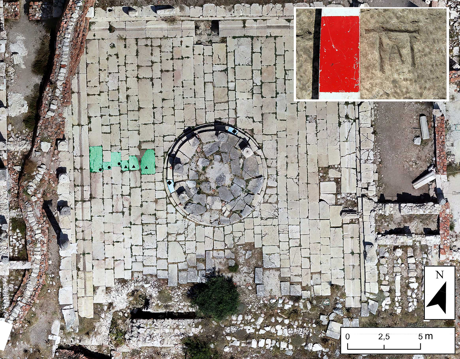
Figure 10. Orthographic image of the Makellon showing the paving stones with π-shaped marks (green), π-shaped marks with and without smaller A-shaped marks (dots and triangles, respectively), and the larger A-shaped marks on the Tholos’ crepidoma (blue, marks indicated by diamonds). Top right: close-up of a mark.
State of preservation
Both the central courtyard and the tholos remained unaffected by large-scale fifth- to sixth-century ad modifications (Richard, Reference Richard2007; Beaujean, Reference Beaujean2018). The only major discrepancy in preservation is the collapse of the southernmost paving. Because it was completely buried, its preservation is excellent.
Spatial patterns
In the western section, six π-shaped marks are present in the first six rows east of the western gutter stones. These form a pattern oriented west-east, approximately along the west-east axis of the courtyard (Figure 10). The three westernmost π-shaped marks have a small A-shaped mark carved between their ‘legs’ and are oriented towards the east. In contrast, the three easternmost π-shaped marks (without A-shaped marks) are oriented towards the south (Figure 10). While the collapse of the southern section makes it impossible to establish batch demarcation, the similarities with paving practices observed elsewhere suggest a comparable process.
The absence of stonemasons’ marks in the eastern part of the courtyard is striking, as it is well-preserved. If both halves were paved at the same time, it seems that the stonemasons’ marks did not play a role in the paving of the eastern half. As the proposed use of the marks was to ensure adequate payment for organization and/or labour, a deliberate absence of marks suggests that payment was either not necessary or arranged otherwise.
We can only state that the three Α-shaped marks on the blocks of the second step of the tholos were part of the same construction process. Possibly, there was a relation between these larger A-shaped marks, and those smaller A-shaped marks added to the π-shaped marks (see below).
Discussion
Our four case studies indicate that the uses of stonemasons’ marks are two-fold: as a label identifying the individuals or groups responsible for setting and possibly also processing and transporting the blocks, and as paired labels identifying the extent of two adjoining batches of placed stones. This use of stonemasons’ marks as batch identifiers has recently been suggested to explain patterns of such marks on other sites (Bessac, Reference Bessac and Medina2015: 587–88). For Roman Imperial Sagalassos, this type of mark has only been encountered on paving stones and stairs.
Our use of the term stonemason in stonemasons’ marks should not be restricted to craftsmen carving stones in a workshop. Our conception of how Roman construction was organized assumes that the upper echelon of management (ideally urban administrative bodies and/or promoters and architects) auctioned specific tasks to contractors, who subsequently hired subcontractors and/or skilled labour (Gutiérrez Garcia-Moreno & Vinci, Reference Gutiérrez Garcia-Moreno, Vinci, Brysbaert, Klinkenberg, Gutiérrez Garcia-Moreno and Vikatou2018: 286–87). While our results cannot entirely resolve how construction and paving were organized locally, combining these datasets does offer diachronic evidence helping us to identify the stonemason(s) represented by the stonemasons’ marks. Since these marks denote a batch, they pertained to multiple blocks, which had been extracted in a local quarry, probably pre-processed and transported to the paving and/or construction site. These activities required the extraction of raw materials and other types of skilled labour that needed to be hired. If the marks were only associated with quarrying or pre-processing, one would not expect the patterns we have documented, which suggest the marks were carved upon placement. This ensured that the delivered batches remained visible, presumably until payment was received. Furthermore, the patterns identified make a relation to transport extremely unlikely. The marks either delineated a batch placed by a group of workmen (including at least one stonemason to make the final adjustments) or a batch belonging to one (sub)contractor who organized part of the process from quarry to placement. Since our results refer to spatio-temporally distinct case studies, these options may vary, depending on the construction and/or paving operation undertaken.
A major difference between the first-century ad paving processes on the Upper and Lower Agora and the later construction and paving operations of the Hadrianic Nymphaeum and the Makellon is the number and variety of marks. Especially on the Upper Agora, the distribution and clustering of marks appear more ‘chaotic’. One has to keep in mind that this was probably one of, if not the first and largest, major paving operation in Sagalassos. Moreover, the growth in construction work, which would be sustained for over three centuries, was only just beginning. While some experienced architects and craftsmen could have come from elsewhere, most of the (sub)contractors and skilled labour must have been relatively inexperienced local people: they were learning on the job and might initially have adapted construction techniques — like the use of construction-related marks — to large-scale paving. Additionally, many different actors may have seized this new lucrative opportunity, and only organized and/or undercut each other as time went on, resulting in fewer ‘teams’ during later paving processes (e.g. at the Makellon). Despite this relative inexperience and possible opportunism, it seems unlikely that the decision-makers hired a great many (sub)contractors to oversee individual sections of the paving of the Upper and Lower Agora. Consequently, for the Upper and Lower Agora, the batches delineated by stonemasons’ marks are likely to relate to the allocation to certain sectors of teams consisting of workmen and at least one stonemason for the finishing touch. These teams seem to have been paid according to the number and/or distance covered by limestone slabs and demarcated these batches accordingly.
For the Hadrianic Nymphaeum, the uniformity of the marks suggests that a single party delivered the blocks for the steps. Here, the reason for these marks was not to stake a claim, but to delineate the batches to be paid for by two separate heirs. The stonemasons’ marks probably refer to a (sub)contractor responsible for organizing this part of the construction process, and the sum each promoter owed him or her.
For the Makellon, the interpretation is difficult. The inscriptions tell us that at least one member of the local elite invested in the construction of the porticoes and their entablature, and that the city paid for the courtyard's paving and possibly the tholos, which seem to have been paved or constructed at a somewhat later date. The stonemasons’ marks are thus associated with this second phase. As each type of identifier is uniform for each operation, they are likely to refer to (sub)contractors responsible for the courtyard's partial paving and the construction of the tholos’ crepidoma (three-stepped platform), respectively. Here, the addition of a smaller Α-type mark inside the ‘legs’ of the π-type marks documented in the western half is intriguing. If they refer to different teams, one would also expect a differentiating mark within the three easternmost π-marks. It may be that we are dealing with a partial cooperation or take-over between those responsible for the crepidoma (marked by larger A-type marks) and the paving.
In addition to identifying the function of the stonemasons’ marks and investigating the local labour organization they may document, combining the spatial, stone-carving, and epigraphic data proved fruitful in increasing our understanding of the commissioning of the Hadrianic Nymphaeum. The dual stone carving techniques hint at negotiations between the heirs of the commissioner, Tiberius Claudius Piso, and some of the parties responsible for construction. Undoubtedly, the differences in stone carving techniques had financial implications, because reworking the slightly raised punched rustications with a pointed claw chisel is an additional operation and thus has financial implications. As for the positioning of stonemasons’ marks on the stairs, it indicates individual payments for separately delivered batches of blocks. These combined observations reinforce the hypothesis that the construction of the Nymphaeum was conducted under the direction of the two heirs and suggests a carefully maintained split accountancy regarding payment. The different surface treatment suggests that turning Piso's request in his will into a nymphaeum resulted in a difference of opinion regarding the surface finishing, which could be financially motivated. In part, this argument is complicated by an examination of the decorative architectural elements of the architrave-frieze blocks and cornices (Waelkens et al., Reference Waelkens, Üner, Richard, Kurapkat and Wulf-Rheidt2017). Waelkens and colleagues distinguished five to six individuals or teams of stonemasons working in parallel on the architectural decoration of this monument, but also found evidence of half-finished elements. They suspected that Piso's heirs took less care over the finer details of the decorative parts of the fountain and suggested that a quick completion of the Nymphaeum was part of their motivation.
Conclusion
At Roman Imperial Sagalassos, the combined analyses of stonemasons’ marks and stone carving techniques of the Upper Agora, Lower Agora, Hadrianic Nymphaeum, and the Makellon have provided new insights into the function of stonemasons’ marks in paving and building activities and revealed the marks’ potential for examining past labour organization. This study contributes not only to the site of Sagalassos and Classical archaeology, but also to the glyptographic analysis of stone marks, no matter the period. The issue of random patterns of stonemasons’ marks is common, appearing frequently in comparable studies. Several possibilities are usually suggested, such as the use of painted marks, which are seldom preserved, or the presence of marks on the obscured sides of ashlars or paving stones, which are mostly inaccessible. Although these answers can be correct, the use as batch marks proposed here provides another solution. We believe that combining analyses of stonemasons’ marks, stone carving techniques, and building-related epigraphic datasets can facilitate an in-depth study of construction and paving organization on a broader scale. This kind of research greatly benefits from the advantages of 3D-documentation, which allows for image manipulation and the spatial analyses of large structures and public spaces. Such studies, carried out for various parts of the Roman Empire, can thus lead to further testing and refining our conceptions of the organization of Roman construction and throw light on the various individuals engaged in it.
Acknowledgements
This work was supported by the Research Foundation Flanders (FWO) under grant 1106618N. The authors express their gratitude to all those involved in excavating and documenting the discussed structures and squares. We especially thank Jeroen Poblome for his suggestions and critical remarks. This article is based on data from the PhD research of the two authors.


