


Introduction
Humans have strategically utilised space, with rockshelters and caves serving as recurrent occupation sites, throughout prehistory. The use of such locations has been the subject of several studies in the Pampas, Patagonia and southern Brazil (see Schmidt Reference Schmidt2004; Miotti et al. Reference Miotti, Marchionni, Mosquera, Hermo and Ceraso2014, among others) but has received relatively limited attention in Uruguay (Cabrera Reference Cabrera, Consens, López-Mazz and Curbelo1995; Suárez et al. Reference Suárez, Leigh and Trindade2011; Aguirrezábal Reference Aguirrezábal2021). In this article, we present results from a recent research project in two archaeologically unexplored regions of Uruguay.
Study area and methodology
The studied areas encompassed two sectors, one in the west (Uruguay River Basin, Paysandú department) and another in the east of Uruguay (Merín Lagoon Basin, Cerro Largo department) (Figure 1).

Figure 1. Maps of the two study areas (figure by Flavia Barceló).
Research in these sectors included systematic pedestrian surveys, recording of archaeological sites, conducting surface collections and performing stratigraphic tests and excavations. Aerial, satellite and drone surveys additionally provided a landscape overview.
Methodologically, the research is carried out through an interdisciplinary approach with the participation of archaeologists, geologists, speleologists, palaeontologists and palaeoecologists. To the west, research focused on the region known as the Queguay limestones (Figures 1 & 2). This region provides optimal conditions for the formation of rock concavities and is itself a significant outcrop of silcrete. Excavation focused on María Piquet, Cuervos and Tigre hills (Figure 3). Archaeological excavations in the east focused on the upper Tacuarí river, where we discovered a series of caves and rockshelters spatially and chronologically associated with anthropic earthen mounds. A total of 42.7m2 has so far been excavated in both regions: 8m2 in caves, 20.5m2 in rockshelters and 14.2m2 on earthen mounds.

Figure 2. Archaeological sites identified in Western Uruguay (Paysandú): A) surface workshop on Cuervos Hill; B–E) large silcrete outcrops on María Piquet Hill (figure by Rafael Suárez & Flavia Barceló).

Figure 3. A) panoramic view of Cuervos Hill; B) La Deseada Cave; C) stratigraphic sequence of Queguay Cave, note black sediment lens; D) stratigraphic sequence of La Deseada Cave (figure by Rafael Suárez & Flavia Barceló).
Results
Intensive surveys have helped identify cultural landscapes in both areas. We have discovered two systems of caves and rockshelters, one in the Queguay Formation (limestone) with extensive workshops and silcrete resources and the other in the Tres Islas Formation (sandstone) (Figures 2, 3 & 4A). To date, 11 caves, 35 rockshelters, 24 outcrops (silcrete and silicified sandstone), three ochre outcrops, six cairns and 315 earthen mounds have been identified in both study areas. We expect these numbers to increase in the next years of research.

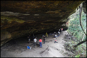
Figure 4. Archaeological sites in Eastern Uruguay (Cerro Largo): A) Tamanduá rockshelter; B) group of mounds in the foreground (yellow arrows) and Tamanduá rockshelter in the background (red arrow); C) detail of earthen mound (pictured in B) (figure by Rafael Suárez & Flavia Barceló).
Excavation was undertaken in the Tamanduá rockshelter due to its high stratigraphic resolution; 17.5m2 have been excavated so far and six AMS radiocarbon dates obtained (Table 1). The most recent ages, obtained from layers containing ceramic, bone and lithic material at 0.075 and 0.12m below the surface, indicate activity from the historical period c. 315 ± 15 BP (UCIAMS 263944). In addition, there is a fragment of Guaraní corrugated ceramic dated to 845 ± 15 BP (UCIAMS 273240), an occupation dated to 990 ± 15 BP (UCIAMS 263943), and another one between 0.30 and 0.33m deep, dated to 2865 ± 15 BP (UCIAMS 263942). Finally, below these, there are other archaeological contexts, one at 0.60m dated at 5060 ± 15 BP (UCIAMS 273231), and another one at 0.87m with a date of 10 085 ± 35 BP (UCIAMS 273241) (Table 1, Figure 5).
Table 1. AMS dates obtained in the Tamanduá rockshelter.

Calibration performed with Calib 8.2 SHcal20.14c (95.4% confidence) (Hogg et al. Reference Hogg2020). All dates were obtained by AMS 14C method.

Figure 5. Southern profile of Tamanduá rockshelter with stratigraphic units and radiocarbon dates (figure by Flavia Barceló).
Lithic materials encompass quartz artefacts and silcrete (silicified limestone) lithic flakes. Many ceramic fragments are plain (Figure 6A) but some show nail-prints, stick-prints and corrugated decorations (Figure 6E & F). The macrobotanical remains include burnt endocarps from Butia odorata (Butiá) and Syagrus romanzoffiana (Pindó) palms, burnt branches and charcoal from hearths. These burnt endocarps, dated at c. 3000 and 1100 cal BP, indicate the use of palm drupes (the fruit of the palm) during two Middle Holocene human occupations at the Tamanduá rockshelter.

Figure 6. Examples of archaeological material from Tamanduá rockshelter: A) plain ceramic rim; B) red ochre with concavity and marks produced by lithic artefacts (note parallel vertical lines in the concavity); C) silcrete flake; D) ceramic fragment; E) ceramic rim decorated with nail-prints and stick-prints; F) large fragment of Guaraní corrugated ceramic dated at 845 ± 15 BP (1247 cal AD) (figure by authors).
Discussion: cultural transformations
Evidence from Tamanduá rockshelter suggests that there has been a sequence of human occupations spanning at least the past 11 500 years, extending up to the historic period.
Presence of allochthonous raw material, such as silcrete (Figure 6C), indicates that it was transported from outcrops located 312–479km from the Tamanduá rockshelter.
The most recent dated archaeological context corresponds to historic ethnic groups from the late sixteenth and mid-seventeenth centuries (1510–1653 cal AD). According to some ethnographic data, the region where Tamanduá rockshelter is located was occupied by Guenoa-Minuan Indians in the late seventeenth century (Bracco Reference Bracco2004). Similar dates have been obtained at some sites of mound builders (Bracco Reference Bracco2006), which may indicate an occupation associated with these societies. The presence at Tamanduá rockshelter of plain ceramic fragments (Figure 6A), which are characteristic of mound builders, further supports such an interpretation. The c. 3000 cal BP occupation is also probably associated with mound builders groups from south-east Uruguay and south Brazil (see Milheira & Gianotti Reference Milheira and Gianotti2018, among others). Supporting this interpretation, a total of 173 mounds have been identified at distances between 120 and 1102m from the Tamanduá rockshelter (Figure 4B). Together this evidence suggests that Tamanduá rockshelter may represent a new type of site for the mound-builders cultural tradition.
A probable Guaraní occupation is identified during the Late Holocene period, c. 1250 cal AD. The presence of Guaraní ceramics may indicate either an occupation by that cultural group or their influence in the area through different types of contact and/or exchange networks with other groups. It should be noted that Guaraní ceramics have not previously been reported in cave or rockshelter contexts.
Finally, there is a Middle Holocene occupation (c. 5800 cal BP) with ochre fragments. Below this, there is another probable Early Holocene occupation associated with a lens of organic matter from which a charcoal sample was dated to c. 11 500 cal BP.
Conclusions and future perspectives
The identification of numerous archaeological sites and the evidence recovered from Tamanduá rockshelter demonstrate the archaeological potential of caves and rockshelters in this region of the world, and their significance for understanding cultural transformations during Uruguayan prehistory.
Although the research is in its early stages, the findings thus far are promising, revealing an unexplored archaeological landscape. The ongoing investigations contribute to expanding our knowledge of the prehistoric societies that inhabited south-eastern South America.
Acknowledgements
We would like to thank the Intendencia Departamental Cerro Largo, Regimiento Caballería Blindado 8, the Olivera family and archaeology students involved in the excavations and surveys.
Funding statement
The investigations are part of the projects funded by the Wenner Gren Foundation (grants # 9978 and #10581), Universidad de la República (CSIC I+D 2020) and Fondo Clemente Estable-ANII (FCE-1-2021-166543). This project has been carried out in areas authorised by the Comisión de Patrimonio Cultural de la Nación (CPCN).


