Chapter Four An Early Medieval Chiefdom of Northern Clare: Archaeological Investigations
This section is concerned with the period preceding the advent of the Anglo-Normans in Co. Clare. The geographical focus here narrows as the Burren and environs in northwestern Co. Clare become the center of interest for detailed analyses. However, the disciplinary scope of the examination becomes much wider as the archaeological record, local ecology, and aspects of the ethnohistorical record come under scrutiny. It will eventually become clear that the Burren’s geographical position at the periphery of both Thomond and Munster provides a unique vantage point for the elucidation of the social and cultural history of the province of Munster as a whole.
The Physiography of the Burren
When one conjures forth a mental image of an Irish landscape, it is not the Burren’s physiography that typically comes to mind. Indeed, the Burren is a locale unique to Ireland given the striking juxtaposition of karst geology, the presence of rare species in the local plant communities, and the extensively preserved archaeological landscapes from various cultural periods. As the geology, climate, and plant communities of the Burren have had an impact on the past social and subsistence adaptations in this region, it is worthwhile to outline the relevant dimensions of the Burren’s physiography. I will not bore the reader with a thorough recitation of the cultural history of the Burren here, much of which lies beyond the scope of this work. Rather, I will discuss the level of preservation of the archaeological remains in this locale and describe briefly the variety of monuments one encounters in the field from the different cultural periods.
The present-day visitor to the Burren is left with an impression of desolate solitude, as the panorama he or she is confronted with is largely treeless, consisting in the main of towering bare white limestone hills and cliffs. The descriptions of the Burren made by Edmond Ludlow, Cromwell’s general who visited the region in 1651, and the semipoetic description of the area left by Mac Craith in Caithréim Thoirdhealbhaigh in the fourteenth century leave the reader with the impression that the Burren has remained physically unchanged over the last 500 years:
… he cast about to shift for himself and so took a precipitate eastward course to the skirts of the Burren, that is hoary and slippery with her crag. Over wide Burren’s naked hills …
In this guise they made their way in the edge-stoned huge-rocked rough-hilled land of Corc; through Burren’s uncouth ways, narrow gaps, crooked passes, rugged boulders, and high sharp crests …
… of which it is said (of the Burren) that it is a country where there is not water enough to drown a man, wood enough to hang one, nor earth enough to bury him, which is last so scarce that the inhabitants steal it from each other, and yet their cattle are very fat, for the grass growing in turfs of earth of two or three foot square, that lie between the rocks, which are of limestone, is very sweet and nourishing.
However, this impression of geographical and ecological stability gives way under closer scrutiny. To begin with the more recent lines of evidence, photographs and drawings of the Burren’s archaeological sites made in the course of the surveys carried out by T. J. Westropp and George Macnamara in the late nineteenth century show a landscape almost completely devoid of bushy or arboreal vegetation. Today, many of the same sites illustrated by these energetic scholars are covered by thick copses of hazel, sloe, blackthorn, and blackberry brambles rendering complete penetration of some of these areas impossible. Over the course of a century, a tremendous amount of regrowth has obviously occurred. The dramatic drop in the numbers of the Burren’s inhabitants since the Famine, coupled with a switch to oil, gas, electricity, and turf purchased in the nearby towns, has relieved pressure on the local vegetation to supply the fuel needs of the region. The consequent regrowth of bushy scrub forced the farmers to use bulldozers to reclaim pasture land in the lower areas in the 1980s.
Recent geological and botanical studies in the Burren show changes of a similar or greater magnitude to have occurred in the prehistoric past. A pollen core from the turlough in the Carron Depression examined by Keith Crabtree revealed that prior to the clearance of vegetation by humans in the Late Neolithic, the Burren possessed a forest cover of pine trees with an undergrowth of hazel (1982:111). This forest cover would have required a more extensive soil cover than exists today (ibid.:112–113; Jones Reference Jones1998:32).
The conclusion drawn from the pollen evidence that ancient forests once existed in the Burren has been corroborated by two independent lines of evidence. Soil profiles from two contexts have been examined by David Drew: deep fissures weathered into the surface of the limestone clint called grikes, and soil preserved underneath monuments of the Late Neolithic/Early Bronze Age periods (1982, 1983). In the former environment rich mineral soils were found that showed characteristics of having been deposited there subsequent to grike formation. The coring or excavation of chambered tombs of the Neolithic and Early Bronze Age, which are presently situated in areas of bare limestone pavement, were found to be resting upon a thin layer of rendzina mineral soil (Drew Reference Drew1983:116–122). Moreover, a comparison of the configurations of solution marks, or karren, on protected and unprotected slabs in megalithic monuments demonstrated that the former had been covered by a soil covering prior to having been incorporated into the prehistoric structures (Drew Reference Drew1983:122–123; Plunkett Dillon Reference Plunkett Dillon, Reeves-Smyth and Hammond1983).
The explanation for the prehistoric loss of soil in the Burren is rather straightforward. The loss of forest cover following clearance for agriculture resulted in a greater exposure of the soil to wind, desiccation, greater light intensities, and water run-off (Crabtree Reference Crabtree, Limbrey and Bell1982:113; Mitchell Reference Mitchell1976:138). The cumulative effect was that the increased run-off and changes in soil chemistry induced by the removal of vegetation promoted the erosion by solution of the underlying limestone bedrock. The thin soil cover was then simply washed down into the expanding grikes, hollows, and caves leaving the limestone clint exposed – a fact that further promoted bedrock erosion and changes in local hydrology, producing the austere landscape visible today (Drew Reference Drew, Limbrey and Bell1982:115–119).
The evidence from the preserved and colluviated soils and from karren morphology suggests that for at least part of the prehistoric period the Burren had an extensive cover of mineral soil, sufficient to support a tree-dominated vegetation cover. The loss of soil and consequent vegetation regression to the present-day plagioclimax of poor pasture probably occurred within a relatively short space of time during the latter part of the Bronze Age.
Archaeology
Clare’s prominent position in Irish historiography and archaeology is due in no small part to the fact that so many prominent scholars hailed from the county. The well-known seventeenth-century scholar Dubaltach MacFirbisig received part of his training at the O’Davoren school at Cahermacnaghten. Other Claremen who have made important contributions to our understanding of the history and folklore of the area include Eugene O’Currey, Standish Hayes O’Grady, Thomas J. Westropp, George Macnamara, and John Hunt.
The Burren’s archaeological monuments were first approached through several extensive surveys. The earliest systematic work was undertaken during the first half of the nineteenth century by the Ordnance Survey, upon which George Petrie, John O’Donovan, and Eugene O’Currey were at times engaged. The maps produced by this survey provided the basic site inventory from which all subsequent surveys have proceeded. The surveyors mapped the more visible of the archaeological sites. The Irish language scholars O’Donovan and later O’Currey recorded place-names, made detailed accounts of the folk and historical associations of archaeological and historic sites, and provided Anglicized versions of names for the maps (Herity and Eogan Reference Herity and Eogan1977:7–9).
Thomas J. Westropp and George Macnamara made up the second team of archaeological surveyors to work in the Burren. Westropp was an engineer by training and Macnamara was a physician. During the latter part of the nineteenth century and the first decades of the twentieth, Westropp surveyed almost every known archaeological site type in Clare, publishing them in several dozen papers and tracts. He was especially attracted to the Burren due to its richness of well-preserved sites, of which the cashel habitation sites of the Early Middle Ages were the most prominent. The archaeological term cashel refers to the still standing remains of the stone enclosing walls that encircled the yard and buildings of a habitation site. It is a rendering in English of the Irish word caiseal (Old Irish caisel), which is cognate with the Latin castellum. Locally, such sites are referred to by the Irish term cathair. This word forms a common prefix to the place-names of these sites, such as Cahercommaun, which originally was Cathair Commáin (Dwelling-place of Commáin). It is typical of place-names incorporating the cathair element that cathair is followed by a personal name. Westropp’s publications included not only drawings and plans of multitudes of cashel sites, but also theories concerning their derivation.
Archaeological surveys undertaken in the decades following Westropp’s work have been narrower in focus. Under the direction of Ruadhrí de Valera and Seán Ó Nualláin, the Megalithic Survey of Ireland has published a catalogue of all known Megalithic monuments in Clare (1961). The 1980s witnessed the debut in the Burren of systematic field surveys of archaeological remains. These surveys moved beyond the practice of recording sites in isolation. The geographer Emma Plunkett Dillon undertook a survey of the Burren’s ancient field boundary walls, principally through the examination of preexisting aerial photographs (Plunkett Dillon Reference Plunkett Dillon1985). Sinéad Ní Ghabhláin conducted a field survey of the ecclesiastical sites of Corcomroe and Burren Baronies (1995a, 1995b, 1996, 2006), and Carleton Jones and Christine Grant have undertaken intensive mapping projects of locales in the Burren possessing well-preserved field boundary walls, habitation sites, and chambered tombs (C. Grant Reference Grant1995; Jones Reference Jones1997, Reference Jones1998; Jones and Walsh Reference Jones and Walsh1996).
The Early Middle Ages
This era’s appearance of distinctiveness is due to the advent of Christianity in Ireland during the fourth to fifth centuries AD. Christianity established new avenues of communication between Ireland and the rest of Europe through which ideas and goods flowed. An accompaniment of the introduction of writing to Ireland was the Latin concept of the keeping of annals. Though record keeping in Ireland did not really commence in a big way until the eighth century AD, memories of many earlier events that had been maintained by a vigorous oral tradition were transcribed onto vellum at that time.
Medieval settlement remains are profuse in the Burren, and the architecture of these sites is preserved to the extent that on the larger Early Medieval period habitation sites, enclosure walls still stand to a height of over 2 meters. Further, the foundations of buildings inside enclosures can frequently be made out. Over the years, Irish archaeologists have developed a morphological typology of settlement types partially grounded in ethnohistorical references to sites. For that reason, the typology consists of Irish terms, and it may be helpful for the nonspecialist reader to briefly review the terminology, especially as it departs in some instances from the local vocabulary of Co. Clare.
The earthen equivalent of the cashels are termed raths. The original Irish word from which this is derived, ráth, has much the same connotation as the word cathair. Another Gaelic word describing the same sort of site, lios, is a more common component of place-names in the Burren. Linguistically, the word ráth refers to the enclosing earthen bank of the settlement, while the word lios refers to the habitation area so enclosed. The Cahercommaun Project, directed by the author, made a systematic survey of settlements of these types in the eastern portion of the Burren in 1984–1986 and 1993.
Crannogs are a third habitation site-type of the Late Iron Age. The word crannóg refers to a structure composed of wood. They are dwellings established upon artificial islands of brushwood in lakes or marshes. Scholars in the past have equated crannogs with rath-type settlements. Most crannog excavations have yielded rich artifact inventories and prolific evidence for specialized craft production, demonstrating that these sites were established by chieftains in the Early Middle Ages (Gibson Reference Gibson1982:chap. 5; Gibson Reference Gibson, Blair Gibson and Geselowitz1988:54; O’Sullivan Reference O’Sullivan1998:136–141). Due to the paucity of permanent bodies of water, very few sites of this type have been located in the Burren proper.
The last type of site deserving mention in this section are the ecclesiastical establishments. There are a number of different religious site-types of this period; including holy wells and burial grounds for unbaptized children called killeens (cillín). The two most substantial varieties of ecclesiastical site are monasteries (including abbeys and friaries) and churches. The structure of the ecclesiastical sphere of Irish life in northern Co. Clare has been the subject of several recent surveys (Mytum Reference Mytum and Pearce1982; Ní Ghabhláin Reference Ní Ghabhláin1995b, Reference Ní Ghabhláin1996, Reference Ní Ghabhláin2006; Sheehan Reference Sheehan1982).
The Medieval Periods
Social and political aspects of Thomond during the Middle Ages will be discussed in Chapters 8 and 9. Here, I would like to make a few comments concerning the chronological terminology to be used in the remainder of this work. Beyond the failed establishments at Bunratty and Quin, the Anglo-Normans were never able to establish themselves as a lasting presence in Thomond. For this reason, modifications in the cultural history of the Burren probably took a gradual course. Evidence will be offered in subsequent chapters that cashels and raths continued to be constructed after the thirteenth century AD in the Burren. This should hardly be surprising, as it is certain that a few were inhabited up to the seventeenth century.
The Cahercommaun Project: The Strategy of Research
A principal assumption made by the Cahercommaun Project was that the tri-vallate cashel site Cahercommaun was the capital site of a chiefdom of unknown scale and internal structure. Authorship for this assumption must be properly attributed to Hugh O’Neill Hencken, who excavated the site under the auspices of the Third Harvard Archaeological Expedition in Ireland in 1934:
In the early part of IX a chief of North Clare, whose name is not known from historical record, built a stone fort on the edge of a ravine four and a half miles north of the modern village of Corofin. In County Clare little stone forts are to be counted in thousands and most of them must have been mere homesteads … Cahercommaun, being one of the very few larger ones, presumably corresponded to a castle.
As chiefdoms are social systems that are regional in scale, the program of research geared to revealing the organization and extent of the chiefdom polity associated with Cahercommaun would have to be regional in scope. The Cahercomaun Project, as originally conceived, was to consist largely of a systematic field survey including the mapping of known settlement sites of potential Early Medieval date. The survey was to be supplemented by test excavations and soundings to gather carbon samples by which a site chronology could be constructed. It transpired that the soundings and excavations that were undertaken were to be of only marginal significance to the project’s goals. Therefore, the chief body of evidence for the resolution of this project’s objectives was generated by the two-fold program of survey to be described later. Though additional survey and excavation would be desirable, the survey work so far accomplished has achieved much in the way of laying the groundwork for the interpretation of the Burren’s Early Medieval social systems. Excavations that have been carried out in the Burren upon two cashels since the last time that the Cahercommaun Project formally took to the field in 1993 have provided valuable chronological data that have enabled a more precise seriation of the Burren’s medieval aristocratic settlements (M. Fitzpatrick Reference Fitzpatrick2001; Comber and Hull Reference Comber and Hull2010).
The Intensive Survey
A two-fold survey strategy was employed that encompassed three desiderata of the Cahercommaun Project. An initial goal of the project was to determine the extent of the Cahercommaun polity through the discrimination of its former boundaries within patterns in the distribution of Early Medieval settlements and field boundary walls. Among historical geographers, there is a long-standing supposition that the spaces between Irish chiefdoms were thinly populated waste areas of forest and bog (see Ó Riain Reference Ó Riain1972; Smythe Reference Smythe1982:26). This idea seems logical in light of the fact that chiefdom polities were frequently at war with one another and so would presumably wish to isolate themselves from neighboring polities with natural barriers. It was thought, then, that border areas of Irish chiefdoms might manifest themselves as areas where Early Medieval settlements and associated field boundary systems dropped off sharply in frequency.
In order to gather the relevant data, an intensive survey was undertaken of Early Medieval settlements and features that proceeded outward from the region’s focal point, Cahercommaun. Unfortunately, it never proved possible to put the boundary effects hypothesis to a test, as the area that was intensively surveyed proved to be of insufficient extent to do so. This deficiency has been overcome in this study by an analysis of the relationships of the boundaries of historic territories, both secular and ecclesiastical, to Early Medieval settlement in the study region.
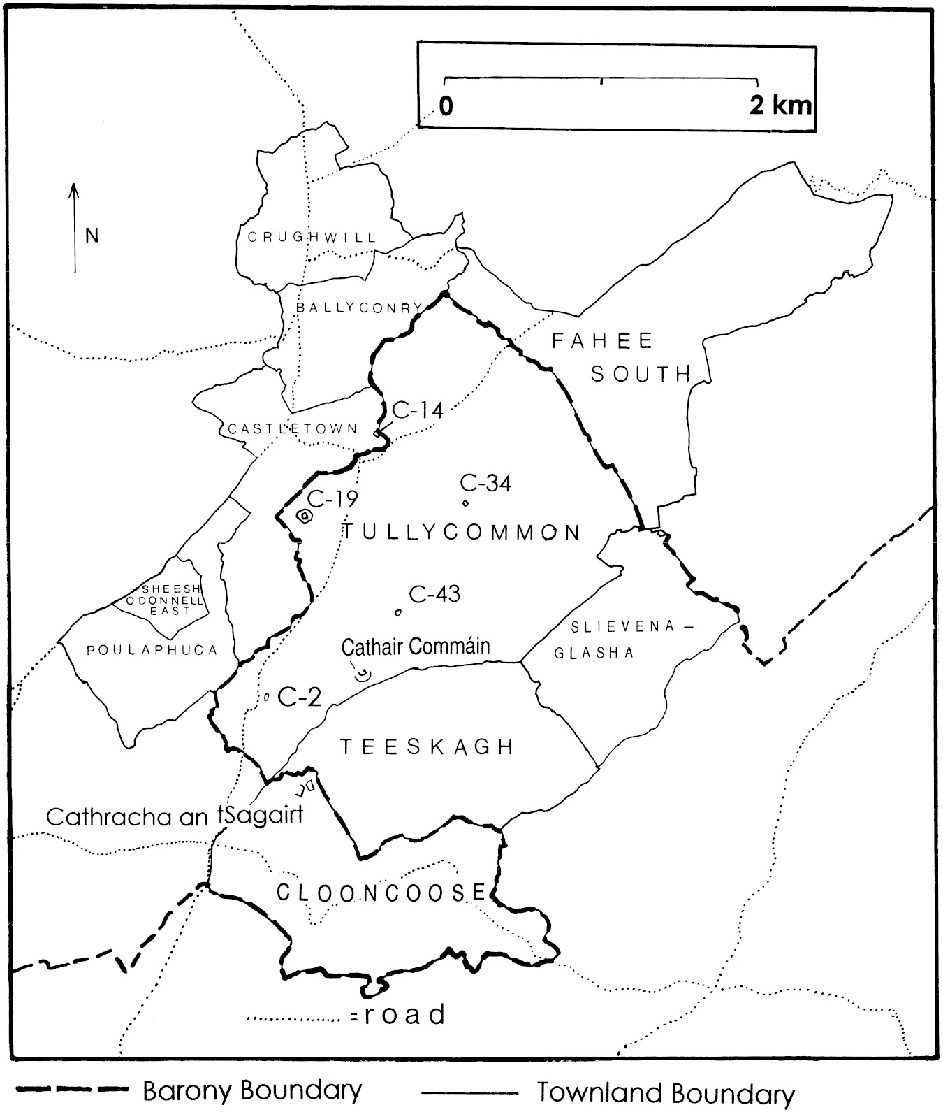
Secondly, it was desired to explore in detail the internal social organization of the Cahercommaun polity as manifested through its settlement remains. It was assumed at the outset that the social complexity of any polity would be reflected in the degree to which a polity was internally stratified, that is, in the number of levels of authority that existed within a chiefdom. Social stratification in turn would be expressed in rank-size differences between households as manifested in differences in the size and elaborateness of their settlements. Attaining this goal would entail gaining some idea of the variation in the size of Early Medieval households and the distribution of households with respect to the location of Cahercommaun. An intensive survey of the townlands within 3 km of this site was undertaken to meet the demands of this portion of the research program (Figure 4.1).

Figure 4.1. Townlands of Carran parish (Burren Barony) and Killinaboy parish (Inchiquin Barony) selected for intensive survey. The position of some cashels and enclosures are noted.
The third desideratum was to reconstruct the structure of the political system of Cahercommaun, and to gain some understanding of the place of this polity within the larger region of Thomond. It was assumed that large Early Medieval settlements would be the former residences of aristocratic families. The size of any one residence was held to correspond to the size of the labor pool an aristocrat would have mobilized to construct it. Labor in Early Medieval Ireland was mobilized though a system of clientship (Gerriets Reference Gerriets1983; F. Kelly Reference Kelly1988:29–35; Patterson Reference Patterson1981). One would reasonably expect that, under these conditions, an aristocrat’s status in the social hierarchy would be commensurate with the number of clients he could call upon to construct his residence. As the Irish aristocracy was internally stratified, the internal complexity of the Cahercommaun polity would be expressed in the rank-size variation exhibited by these residences.
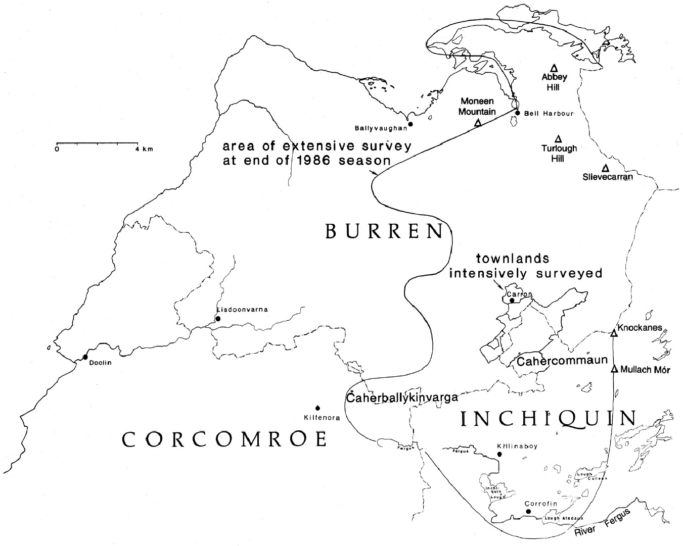
To extend the above logic further, it is expected that the number and relative status ranking of the various chiefdom polities of northern Co. Clare would be reflected in the relative size and distribution of their former chieftain’s principal residences. In order to gain an understanding of the variation in the size of aristocratic residences, an extensive survey of the larger presumed Early Medieval settlements of the Burren and neighboring regions was undertaken (Figure 4.2). The sites were located on Ordnance Survey six-inch maps, and teams were then sent out to map the settlements and record details of their standing architecture. This extensive survey was expansive in design with no predetermined maximum limits. The limiting factor was the amount of time that could be devoted to this portion of the survey within the 1985 and 1986 field seasons (two weeks). Survey teams began by recording the settlements nearest to Cahercommaun and then proceeded to progressively map sites at a greater distance.

Figure 4.2. Northwestern Co. Clare, showing the extent of the area that had been extensively surveyed by the Cahercommaun Project by the end of 1986.
The social structure of the Cahercommaun polity would be expected to have dictated aspects of the organization of economic behavior, just as the economic adaptation of the local population would be expected to have influenced the kinds and sizes of social units in the region (Gibson Reference Gibson, Blair Gibson and Geselowitz1988). Understanding the structure of the local economy through the study of archaeological remains related to subsistence was therefore another goal of the project. This aspect of the research program met with only limited success due to the fact that the two sites chosen for excavation by the project turned out to be prehistoric (Gibson Reference Gibson, Mathieu and Scott2004, Reference Gibson2008a).
Acting upon inspiration derived from Carole Crumley’s project concerned with the Adeui polity of protohistorical Gaul (Crumley and Marquardt Reference Crumley and Marquardt1987), it was decided to adopt a survey design that did not establish predetermined boundaries to the study area. Since the approach adopted by the Cahercommaun Project had as its goal the detection of social boundaries, care was taken not to prejudge or obscure the location of these boundaries by establishing definite limits to the research area. Instead, a strategy of continuous expansion of the survey outward from the focal center, Cahercommaun, was adopted. The survey would commence in the fields near Cahercommaun and expand outward, hopefully taking in the boundaries of Cahercommaun’s polity. The ultimate spatial limits of the survey would lie wherever the survey teams found themselves at the termination of the project.
Naturally, practical considerations dictated that the operation of the survey could not be completely open-ended, and indeed, the organization of survey work must be carried out under strict guidelines to ensure that survey teams record data uniformly and also to ensure that the study region is systematically covered. Each survey team was assigned to investigate blocks of territory with fixed boundaries. A characteristic of the historical geography of modern Ireland is the subdivision of the landscape into small territorial units of variable size called townlands. Within the Burren’s townlands are fields defined by stone boundary walls. Indeed, the borders of townlands in northern Clare are also delimited by stone boundary walls, often of greater than usual height.1 Given these preexisting territorial and physical demarcations of the landscape, it was decided to organize the operation of the survey utilizing townlands and fields as the basic spatial units.
The size of the study region and the complexity of the region’s topography and archaeological record worked to preclude a total survey, and one might think then that some sort of sampling approach would be appropriate. However, there are strong factors that lessen the potential value of random sampling in the context of the Burren. First of all, all techniques of random sampling for survey known to the author (cf. Redman Reference Redman1974) employ basic sampling units of standardized size and orientation. Uniform sampling units are necessary to ensure even coverage of the study region, preventing sample bias. The efficiency of field crews is increased when the sampling units are of uniform size and orientation. Sampling units of uniform size also place less of a burden on the statistician in that less effort is needed to generate a sample, and the areal coverage of the sample can be more easily calculated.
However, regions where random sampling techniques have been employed possess the qualities of being only loosely or nonuniformly compartmentalized by human activity. They are also regions where such land divisions such as field boundaries may exist, but have not been systematically printed on maps. Random sampling is thus valuable for imposing organization and regularity upon an environment that, from the scientist’s perspective, is irregular and of uncertain dimensions.
Ireland’s landscape is almost completely anthropogenic. In the Burren, all land, including mountains and barren expanses (with the exception of bogs), has been compartmentalized into fields by often substantial stone boundary walls. In Ireland, field boundaries, while not impervious to change, are not often modified and have been accurately and repeatedly mapped since the mid-nineteenth century. To impose an arbitrary survey sampling grid onto the preexisting field divisions of the Irish landscape has little practical value. Survey crews would be requested to clamber over innumerable walls, often to record only portions of fields.
The torturous Burren landscape, with its many cliffs, deep ravines, dense thickets, and high, rugged hills, poses additional complications to any survey employing a random sampling strategy. It was felt that much valuable time would be lost in tackling the physical challenges of the Burren’s landscape under a strategy that did not acknowledge them. In this situation, a nonrandom approach utilizing preestablished survey units was selected. In the words of Zvelebil et al., “The practical benefits of using … fields rather than arbitrary grids or transects are obvious since the Irish landscape is broken into landtracts that can be easily identified on the Ordnance Survey Maps” (1987:16).
Another prime consideration in devising a survey strategy is the physical dimension of the sites composing the archaeological record. Random sampling strategies are often favored in the study of the archaeological remains of hunters and gatherers and primitive horticulturalists, as the sites and settlements of these peoples are physical isolates. There are no roads or other man-made structures that connect them. In the British Isles it is now obvious that since the Neolithic period, settlements in many, if not most, areas, were often physically integrated into enormous complexes by expansive systems of fields and roads. These systems incorporated homesteads, fields, roads and droveways, ceremonial centers including burial monuments, and defensive features. I believe that it is difficult to comprehend a regionally integrated system by viewing its parts in isolation. This is especially true with respect to field systems. Field systems can reveal the extent of a regionally integrated community and give information on the structuring of the subsistence economy. One cannot hope to reap this harvest of information from small isolated segments of field systems.
I decided then to survey the fields within the selected townlands intensively and systematically in toto, recording all sites and field systems. Tullycommon townland was selected for survey as it contained Cahercommaun. The next two townlands closest to this site, Castletown to the northwest and Teeskagh to the southeast, were also chosen as a part of the initial area to be intensively surveyed (see Figure 4.1).
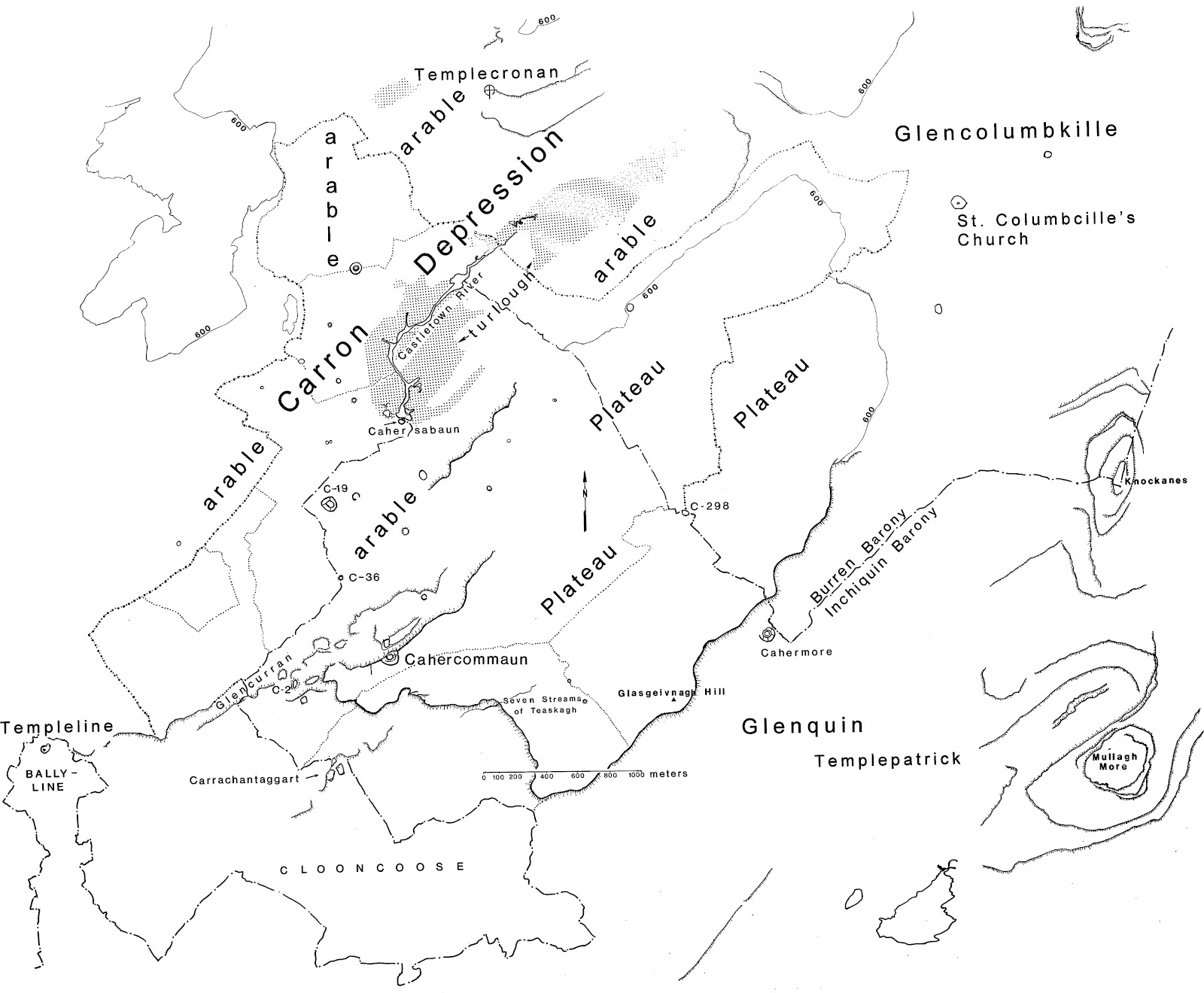
These three townlands offer a good mixture of topography (see Figure 4.3). A high plateau is to be found in the southern and western portions of Tullycommon townland. This plateau extends into Teeskagh townland to the south, and to the west into the townlands of Slievenaglasha, Knockans Upper, Cappaghkennedy, and Fahee South. To the east, Tullycommon dips to take in Glencurran, a wild ravine, and the grassy eastern slopes and bottom of the Carron depression. In the north, the bare limestone of the depression’s bottom gives way to the Carron turlough east of the Castletown River.

Figure 4.3. The townlands selected for intensive survey by the Cahercommaun Project, viewed against local topography.
Castletown townland has an odd shape, making one suspect that other townlands have been cut from it or added onto it in the past. It covers the greatest part of the southern portion of the Carron depression, including the southernmost part of the Carron turlough (just north of the Castletown tower-house). The northern portion of Castletown contains arable land, while the southern part (to the south of the townland name on the map, Figure 4.1) has only scattered soil and much exposed bedrock. Interestingly, this latter area was covered by a dense network of abandoned field systems. Sadly, following the 1985 field season, these were cleared by bulldozer after only a portion of them had been surveyed.
Teeskagh townland is windswept and desolate in appearance. The portion of the plateau that lies within it is bisected by a semisubterranean stream, the “Seven Streams of Teeskagh,” named for the number of waterfalls that appear after a good rain where the stream cascades over the edge of the plateau. This stream then flows to the west along the plateau’s base. There is a spring near the Carrachantaggart enclosure immediately to the south of the townland border. The central and western portion of Teeskagh is a limestone shelf. The shelf is tilted, and is higher in elevation in the south. The southern townland boundary wall marks the point of demarcation between this shelf and the steep northern slope of Clooncoose (Cluain Cuais [the meadow of the hollow]), a narrow, steep-sided grassy valley (Figure 4.4). This southern higher portion of the shelf in Teeskagh is nearly devoid of any soil. By contrast, the portion of the shelf at the base of the plateau is covered with dense thickets. Up to the second half of this century this latter area was the sole focus of human habitation in this townland.
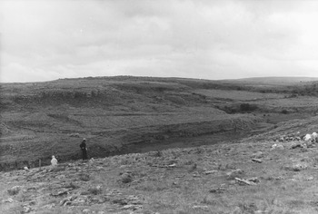
Figure 4.4. Clooncoose (Cluain Cuais) viewed from Teeskagh townland (photo: Blair Gibson).
A favorable aspect of these three townlands from the project’s perspective is that they are positioned astride the boundary between Inchiquin and Burren baronies (Figure 4.1). Teeskagh and Tullycommon townlands lay in Inchiquin Barony, and Castletown in Burren Barony. Political systems and social groupings often express themselves through the demarcation of land, and so it was important to gain some idea of the antiquity of County Clare’s historical territorial divisions: the townlands, parishes, and baronies. It was hoped that the boundaries would reveal their age through patterns in the distribution of archaeological sites, and in the extent of the ancient field boundary walls associated with these.
The Intensive Survey: Procedure and Results
The intensive survey was conducted over the span of four summers from 1984 to 1986, and 1993. Work was initiated with a pilot survey undertaken in August and September in 1984. With the assistance of a local boy, I surveyed a portion of the bottom of the Carron depression extending from Crughwill townland along the eastern side of the turlough proceeding south in the direction of Cahercommaun (see Figure 4.5). In this manner the central portion of the townland of Ballyconry was surveyed, taking in sloping arable land at the western side of the depression.
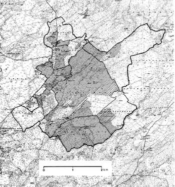
Figure 4.5. The extent of the intensive survey as of the end of the 1993 field season.
Full-scale survey operations commenced in the summer of 1985. Three survey teams were employed, each consisting of three persons and a crew chief. In Ireland all open soil areas are covered by a grass mat, making artifact scatters invisible to the naked eye. However, the rough and uneven terrain and the small size and slight remains of some sites such as clocháns (stone beehive huts), huts, and mound walls (prehistoric walls so eroded so that only a slight mound remains) demanded that the survey crew work as a compact unit. Crew members lined up and spaced themselves close enough to each other so as to be able to see clearly the ground surface between them. The intervals between crew members varied with the vegetation cover and the size of the field surveyed, but they were generally less than 10 m.
The survey of each townland was begun in the northwesternmost field. The crews surveyed townlands moving through strips of fields proceeding gradually south and east. Two standardized recording forms were used to record data: a site recording form and a wall architecture recording form for both the structural walls on sites and field boundary walls. On the site recording form the crews were asked to classify the sites and features encountered under a known Irish type (e.g., cashel), or form (e.g., hut foundations), or to otherwise describe it. Late Neolithic and Early Bronze Age burial structures were not recorded in detail, and only the positions of cairns were noted.
The crews mapped each site that was encountered using a Brunton pocket transit mounted upon a tripod, and tapes. The surveyors prepared drawings of elevations of sections of the surviving architecture of the sites on separate forms. The layout of all field boundary walls and traces of field walls were recorded on field copies of sections of the Ordnance Survey maps showing the townlands, and elevations were made of a section of each field boundary wall that was encountered for purposes of determining whether chronologically sensitive stylistic changes in construction could be detected.
The survey did not proceed as quickly as hoped. Crews were hindered by three principal factors. The ruggedness of the terrain presented considerable difficulty. Crews were instructed to survey all of the land in their path, including large expanses of nearly impenetrable hazel thickets containing a profusion of three species of thorny plants. Even though each crew was supplied with machetes, they returned in the evening with clothing torn to shreds. The Carron turlough in Tullycommon also presented survey problems. It was difficult to gain a sure footing in the marshy sediments, and one crew chief nearly disappeared into a deceptively deep pool. Record rainfall marked both the 1985 and 1986 seasons, and many days were lost waiting out rainstorms. Finally, the survey crews encountered a tremendous profusion of sites and field boundary walls, roughly 300 of each. Often individual areas were very complex, containing a dense concentration of sites and field systems necessitating many days to record them.
Figure 4.5 shows the amount of land that had been intensively surveyed by the end of the 1993 field season. It was possible to completely survey all of Teeskagh townland; however, time did not permit the completion of the survey of Castletown and Tullycommon townlands. This was particularly unfortunate in the case of Castletown townland as the portion that was not completed was subsequently cleared by bulldozer. In addition to the initial three townlands that were selected for survey, small sections of Poulaphuca, Sheeshodonnell East, Fahee South, and Slievenaglasha townlands were also surveyed. They were surveyed for reasons as varied as proximity to routes of access to areas to be surveyed within the initial three townlands, confusion on the part of crew chiefs over the position of townland boundary walls, or the desire to record the continuation of field systems associated with a site lying within a selected townland.
The Extensive Settlement Survey
It was perceived at the start that the intensive survey would not be capable of covering an area large enough to gather settlement data sufficient in quantity and diversity to allow insight into the structure of the regional political system of the Cahercommaun polity, let alone its place in the ancient political order of northern Clare. To judge from the fact that the only apparent rival chiefdom capital in the Burren, Caherballykinvarga, was located at a linear distance from Cahercommaun of nearly 8.5 km, it was thought likely that, at a minimum, the Cahercommaun polity would have encompassed a territory of over 50 sq. km. The initial goal for the first season of intensive survey was to cover an area with a diameter of 6 km, taking in 28 sq. km. The intensive survey would therefore not begin to approach the presumed boundaries of the polity for several seasons and, as it would eventually transpire, not at all. For this reason, a concurrent strategy of selective large settlement mapping was adopted. It was hoped that the rank-size distributions of these sites might alone inform on the degree of social stratification within the Cahercommaun chiefdom, and that the physical distribution of these sites would indicate roughly the location of political boundaries.
In essence, this aspect of the survey design only acknowledged and expanded upon the previous survey work carried out by the Ordnance Survey and T. J. Westropp. As a result of their efforts, the location and plain dimensions of many prehistoric sites were known prior to commencing work. Indeed, so thorough was the Ordnance Survey that probably every enclosed Early Medieval period site 30 m in diameter and larger can be assumed to have been recorded by them. It only remained to comb their maps and select the largest Early Medieval sites for data collection.
Crews visited these sites in order to map them and collect data on aspects of the sites not covered by the earlier surveys, such as the architecture of standing site enclosure walls and their thickness. The larger sites possessed substantial standing dry-stone architecture, and it was hoped that patterns in the style of construction of the walls of these settlements would allow for the creation of a seriation scheme for the cashels. Therefore, it was necessary to record a fair number of the walls of these settlements to allow statistical analyses to be undertaken.
The extensive survey was run somewhat like the intensive survey in that it proceeded outward from the core townlands centered upon Cahercommaun. Those large sites nearest to Cahercommaun were recorded first, followed by sites progressively farther away in all directions. As can be seen from Figure 4.5, the survey was carried as far north as Finavarra and Aughinish Island, and as far south as just beyond the southern bank of the Fergus River in Inchiquin Barony. The county boundary between Clare and Galway constituted the eastern boundary of the extensive survey region, and in the west, the survey was brought roughly and incompletely to an imaginary line running between the towns of Ballyvaughan in the north and Kilfenora in the south. This strategy was pursued with the most vigor during the 1985 field season. During the 1986 field season, the only sites that were mapped outside of the intensive survey area were those ecclesiastical sites immediately surrounding Cahercommaun. Only a few additional secular sites were mapped and these lay within the territory already covered in 1985.