


Introduction
This article presents the findings from the recent investigation of the wreck site of a large mid-thirteenth-century cargo ship (henceforth referred to as the Mortar Wreck), located off the southern coast of England, in Dorset. Although wrecks and shipping losses were common in the medieval period, very little archaeological evidence of the ships and trade networks used in this period survive. While the loss of the ship would have been devastating at the time, today the Mortar Wreck provides a single-context archaeological site containing a cross-section of daily life, trade and technology—a unique opportunity to investigate a key period in European history. In addition to describing the background and discovery of the wreck, this article presents the initial interpretation of the ship, its surviving cargo and the evidence for the sailors who worked the vessel.
The mid-thirteenth century AD is often overlooked and overshadowed in English history by the reigns of King John (1199–1216) and Edward I (1272–1307) (Carpenter Reference Carpenter2020). Political history aside, this was a time of relative peace, good climate and a rapidly expanding population and economy (Broadberry et al. Reference Broadberry, Campbell and van Leeuwen2011: 22). England's industries boomed, leading to the construction and expansion of ecclesiastical buildings such as Salisbury Cathedral and Westminster Abbey, along with hundreds of parish churches and monasteries. The crucial element to all this construction work was the ability to transport heavy goods in bulk from source to destination, for which water transport was almost 10 times cheaper than land carriage (Jones Reference Jones2000). With the stone trade, it is thought that the carriage made up the majority of the costs, with the stone itself costing around the same price as transporting it 12 miles (Salzman Reference Salzman1967: 119). Ships and boats were therefore the primary method of transportation with thousands of tonnes of cargo shipped daily around the shores and rivers of England.
The Mortar Wreck ship was carrying a cargo of Purbeck stone, quarried from the Isle of Purbeck on the south Dorset coast (Figure 1). The most famous stone quarried there is known as Purbeck marble; a fossiliferous limestone composed of freshwater snails (Viviparus sp.) that can be polished to give a marble effect. Purbeck marble was used throughout the medieval period for decorative works in churches and cathedrals across England and overseas in Normandy and Ireland (Dru Drury Reference Dru Drury1948), with some historical records suggesting that it may have been exported as far afield as Genoa in the Mediterranean (Haysom Reference Haysom2020: 220) and Søborg in the Baltic (Bencard Reference Bencard1971). Thousands of mass-produced architectural, ornamental and monumental works were quarried, carved and polished by the marblers of Corfe, Dorset, in the mid-thirteenth to fourteenth centuries (Blair Reference Blair, Blair and Ramsey1991: 41). Despite this, we know relatively little about the logistical management of this industry and the wider context of English merchant ships and sailors.

Figure 1. Location of the wreck, towns and geology associated with the medieval Purbeck stone industry (figure by author).
The site
The Mortar Wreck lies in Poole Bay on the western edge of the main shipping channel into Poole Harbour (Figure 1). The site was originally located by divers in 1982, when it was described as a large pile of “quarried stones” measuring “1.5×2ft, piled 3ft high & approximately 6ft long” and added to the Hydrographic Office Wreck Index (UKHO Wreck ID 19600). A later report by the Royal Commission on the Historical Monuments of England (1991: 53) described the site as a possible stone barge, but no other information was recorded. The Channel Deepening Report by Wessex Archaeology (2004: 26) noted that the mound might represent a wreck, but it was not investigated further. Both the Dorset Historic Environment Records and the National Heritage Register for England repeat the UKHO record of the site as a “pile of quarried stones” but with no further information.
In August 2019, archaeologists from Bournemouth University investigated the obstruction as part of a wider scientific monitoring project. This revealed a mound of stones approximately 6m in diameter and 1m high—indicating large sediment loss since it was first recorded in 1982. In addition to the mound, two large ship's timbers and over 24 stone mortars were observed, leading to the moniker of the Mortar Wreck. The Bournemouth University team returned in 2020 to conduct an assessment of the wreck, which revealed more Purbeck marble artefacts, including the remains of three carved, but unpolished grave slabs as well as a large articulated section of the ship's clinker-built (overlapping panels of wood) hull under the stone mound (Figure 2).

Figure 2. The wreck site on the seabed: A) the stone mound; B) mortars; C) grave slabs; D) articulated hull timbers (photographs A & B by author; C & D by Dan Pascoe).
Dendrochronological analysis of the hull timbers indicates that they are of Irish origin with a felling date between 1242 and 1265 (Nayling & Tyers Reference Nayling and Tyers2020). Other finds located on the site include copper-alloy cooking vessels likely used by the crew (Figure 3). In June 2022, the site was designated as a historic wreck under the Protection of Wrecks Act 1973, making it, aside from two Bronze Age sites, the oldest protected wreck in English waters. The entire site has been recorded via photogrammetry, allowing a site plan to be produced (Figure 4).

Figure 3. The cauldron (left), posnet (upper right) and brazier (lower right) recovered from the wreck (figure by author).

Figure 4. Simplified site plan of the wreck (figure by author).
The ship
Three major elements of the ship have been observed and recorded in situ: the lower stempost (the forward-most timber in a ship that would have been ‘scarfed’—a joint that connects two timbers or planks without increasing their dimensions—to the keel); a floor timber (frames that cross the keel); and a large section of articulated hull, consisting of radially split oak planks (strakes), connected together in a clinker (overlapping) fashion, and frames, attached to the hull with treenails (wooden dowels) (Figures 5 & 6).

Figure 5. Hull elements on the wreck (scales are 1m): A) stempost; B) floor timber; C) articulated hull timbers (frames marked with yellow tags) (figure by author).

Figure 6. Basic terminology of a clinker hull (not to scale) (figure by author).
The stempost lies disarticulated to the north of the mound, starboard side up. It is relatively thin at approximately 130mm, but its length (4.5m) and depth (0.58m) suggest a ship of considerable size. A notch or rebate, potentially for the garboard plank (the strake next to the keel) may be seen at the lower end of the stempost measuring 515 × 170mm, thus giving us the angle of the bow. No obvious scarfing could be seen on the timber to clearly identify how it attached to the keel, though this may be present on the underside of the timber.
The disarticulated floor timber has eight joggles (where the outer face of the timber was stepped to fit in with the overlapping clinker hull of varying widths and depths) and it has an enclosed angle of around 155°, suggesting that it was originally located forward of the midships. Limber holes (holes either side of the keel to allow water to flow between the frames) are present on the timber's centre line where it would have crossed the keel. The timber is not symmetrical, with one side significantly more degraded; this side is currently the least exposed part of the timber, suggesting that the sediment dynamics of the site have changed over time.
A large section of the hull exists under the stone mound, including at least nine strakes of planking and several frames. The exact nature and extent of what lies underneath the mound is currently unknown, but it may contain parts of the ship's keel and internal structures such as the mast step.
An estimation of the size of the vessel can be obtained by comparing measurements of the remaining timbers with those of other known thirteenth-century vessels, such as the Magor Pill in Wales (Nayling Reference Nayling1998) and the Kalverev Syd in Denmark (Thomsen & Čvrljak Reference Thomsen and Čvrljak2022). It should be noted that both vessels are significantly smaller than the predicted size of the Mortar Wreck. By measuring the radius curves on the stempost, it is possible to obtain a rough estimation of the shape and size of the bow (McGrail Reference McGrail1993: 7). A radius of 6.5m was found to be the best fit for the outer curve of this timber. The floor timber suggests a minimum beam of approximately 4m; however, this considers only the lower part of the hull, forward of the widest part of the vessel, so the ship was likely much wider at 6–7m. By adding these dimensions to the size of the main stone mound, an estimated length of more than 20m can be obtained, with the bulk cargo of stone centred on the midships of the vessel and the finished goods in the bow. Such a reconstruction marks a large area of the stern where only scant archaeological remains have been observed. It is likely that this is where objects relating to the domestic lives of the crew were located. Other cargo may also have been stored there; beans, fish, oyster shells, wool, plaster and lime were all exported from the Poole Harbour area in the thirteenth century (Hinton Reference Hinton and Hinton2002) but these are unlikely to survive on a wreck site owing to their buoyant and perishable natures.
The dendroprovenance of the hull timbers shows that the trees were grown in Ireland (Nayling & Tyers Reference Nayling and Tyers2020). Although Dublin was known for shipbuilding in the thirteenth century (McGrail Reference McGrail1993: 87), oak planks suitable for shipbuilding were also exported to England (Slattery Reference Slattery2009). Historic records show Irish planks being imported for use in Canterbury and Dover (Salzman Reference Salzman1967: 245). The trade in Irish planks is highlighted by the significant correlation in the dendrochronological analysis between the timbers of the wreck and other imported Irish timbers, notably Salisbury Cathedral (Nayling & Tyers Reference Nayling and Tyers2020: 7). It is thought more likely that the framing timbers were sourced locally to where the vessel was built (Adams & Black Reference Adams and Black2004; Nayling & Tyers Reference Nayling and Tyers2020: 3), though precise dendrochronological dating and provenancing have not yet been conducted.
The wrecked vessel was constructed in the northern-European tradition where the ship was built from the keel up with clinker planking running horizontally from the stem to stern posts (Hutchinson Reference Hutchinson1997: 5–10). Cogs, the other major northern-European ship construction technique, featured straight stemposts and flush laid bottoms (Vlierman Reference Vlierman2020: 60). Although further study of the remains on the seabed is required, the vessel would have likely been double ended and potentially featured a side rudder, as seen on various town seals and manuscripts (Figure 7).

Figure 7. An illustration from a thirteenth-century bestiary depicting a typical merchant ship (Bodleian Library, Oxford, MS. Bodl. 764, fol. 107r (detail), available from https://digital.bodleian.ox.ac.uk/objects/ecf96804-a514-4adc-8779-2dbc4e4b2f1e/surfaces/301094ed-9ec7-4421-b0e7-a26c0c8010cd copyright © Bodleian Library 2018 CC-BY-NC 4.0) (figure by author).
The cargo
Most of the ship's cargo consisted of a large mound of irregular stone rubble, estimated from the photogrammetry to weigh over 30 tonnes. The material has been provisionally identified as Purbeck limestone, likely from the cliffs at Durlston (Andy Webster, pers. comm.). These stones range in size from 300mm to 700mm in diameter, making them unlikely to be ballast. Purbeck limestone was exported in the thirteenth century as the “hard freestone of Corfe” and was used as a general-purpose building stone both locally and further afield—the Tower of London, for example, imported nine shiploads in 1278 (Salzman Reference Salzman1967: 133). This type of stone would have been used for infills and rubble masonry where dressed stone was not required. In addition to the bulk stone cargo, worked stone including three grave slabs, a collection of at least 24 stone mortars, a cresset lamp (where the wick would be floated in oil) and a hand mill were identified in the cargo remains.
Purbeck stone
The quarrying, carving and transport of Purbeck stone are intrinsically linked with many contemporary records including the freight as part of the price (Blair Reference Blair, Blair and Ramsey1991: 43). The stone would have been extracted from various open-cast quarries to the south of the Purbeck ridge (Haysom Reference Haysom2020: 62) or simply picked up from cliff falls on the shore. Archaeological investigations at Quarr Farm in 1994 and 2004 discovered several partially finished marble pieces, including several blocks roughed out into classic grave slab forms and partially finished columns, though these finds could not be securely dated (Haysom Reference Haysom2020: 65). This discovery suggests that at least the rough carving was conducted at the quarries before the stone was transported, reducing the weight of the items and increasing the efficiency of overland transport. Other potential locations for carving include the village of Corfe Castle—where deep layers of marble chippings, including worked items, have been observed during ground works (Dru Drury Reference Dru Drury1948: 75)—workshops in London or the site of intended use. Evidence for local carving is principally interpreted from the distribution of finished pieces in the local area (Lankester & Blair Reference Lankester, Blair and Steer2020). The discovery of the Mortar Wreck, however, provides evidence that marble was, at least occasionally, locally worked and transported out in a carved but unpolished state. The lack of polishing, a specialist and costly skill of the marbler, suggests that pieces were finished on location to avoid damage during transport (Cousins et al. Reference Cousins, Gittos and Gittos2022).
How the material reached the sea is another debate within the wider study of the Purbeck marble industry. Historic documents often mention Corfe's port as ‘Ore’ (Salzman Reference Salzman1967: 89). This was one of the few Purbeck settlements mentioned in the Doomsday Book, which states that it belonged to Milton Abbey and was home to 13 salt workers (Powell-Smith Reference Powell-Smith2019).
Ower, now a farm 5.5km to the north-east of Corfe, is historically considered to be the “chief if not only port” in the area during the medieval period before the trade moved to Swanage in the early eighteenth century (Hutchins Reference Hutchins1774: 188). However, Hutchins also describes the road as “very bad” with “much up and down hill” and thinks that it fell out of use 150 years earlier (Hutchins Reference Hutchins1774: 607). Further historic evidence for the port at Ower comes from the charter of the Company of Marblers and Stonecutters of Purbeck, of which the earliest preserved copy from 1695 (Dorset Archives: D-MOW/Z/4) grants rights to the quay for an annual rent of a pound of pepper and a football to be delivered on Shrove Tuesday—a tradition that continues to this day.
The Ower Peninsula is also home to a large Iron Age port and associated industry in the hinterlands known as the South Deep Moles. This monumental structure stretched out from Ower for 180m to reach the deepwater channel in the harbour, a smaller 55m structure mirrors this from Green Island and dates from around 250 to 200 BC (Markey et al. Reference Markey, Wilkes and Darvill2002). Surveys at Ower have revealed a large Iron Age settlement that was abandoned in the third or fourth century AD with only agricultural use after this date (Cox & Hearne Reference Cox and Hearne1991: 78). A study in 2014 looked for evidence of port activity at Ower but did not find any significant medieval archaeology (Jarvis Reference Jarvis2014). There was, however, enough interest in the area in 1286 for Edward I to select a site to the south of Ower for the construction of a planned town, with a market and harbour, known as Newton; this venture failed with only cropmarks surviving (Dorset County Council 2011).
Salzman (Reference Salzman1967: 156) equates the port of ‘Ore’ with Nore in Purbeck and refers to the production of plaster at Ore Down. Yet there is no town called Nore in Purbeck. One suggestion is that this refers to Norden, directly to the north of Corfe Castle, which is considered the “undisputed” centre of the Purbeck marble industry in the Roman era (Cox & Hearne Reference Cox and Hearne1991: 79). Geographically, Norden sits on the Corfe River, which flows for approximately 3km before reaching the harbour at Wytch. The settlement is also home to significant medieval industrial activity across multiple sites, including timber-lined channels connected to the sea (Cox & Hearne Reference Cox and Hearne1991: 97) and there is evidence for multiple workshops, iron smithing and salt works at the mouth of the Corfe River (Pitman et al. Reference Pitman, Wilkes, Randall, Brown, Manley and Carter2020). The use of rivers to move stone was well attested in the medieval period, with examples including the monks of Sawtry who made a canal specifically to ship stone from the quarries to their abbey (Hutchinson Reference Hutchinson1997: 121).
The name of Wytch itself may also provide evidence to support the Norden to Wytch transport route. Nomenclature for the Corfe River (traditionally known as the Wichen), the settlement, the deepwater channel and the arm of the harbour all stem from the Anglo-Saxon term Wic, which has been interpreted in various ways. Cox and Hearn (Reference Cox and Hearne1991: 17) associate the name with a dairy farm, though the area is mainly saltmarsh and not known for its pasture. More probable connections are with the salt industry (Ekwall Reference Ekwall1960), of which significant archaeological evidence is in the area. A third interpretation is that of an emporium usually associated with a harbour containing a commercial and craft centre (Hodges Reference Hodges2012: 94), which would fit well if the port for Corfe's industry was located here. Either way, more archaeological investigation would be needed on land to resolve this debate.
One way in which the wreck can contribute to the wider topic of cargo handling at sea in the thirteenth century is through consideration of the size and form of the ship. With the current interpretation of the vessel, it is unlikely that the ship itself would have been moored alongside a quay or dock-like facility on the western side of the harbour, which is known for its shallow waters and deep silts. This suggests that the ship may have been loaded at the larger deepwater quays at Wareham or Poole or that it could have moored in the harbour and loaded via lighters (boats to transfer goods and passengers to and from moored ship) carrying goods from all parts of the harbour, including the facilities at Wytch and the beaches of Durlston.
Grave slabs
Grave slabs are a common type of medieval funerary monument and were produced in various stone types across Europe. Purbeck marble grave slabs started out as a high-status symbol in the early thirteenth century with public figures such as the Archbishop of Canterbury, Stephen Langton (d.1228), incorporating a Purbeck grave slab—of a similar type to one found on the wreck—in his tomb in the cathedral (Badham et al. Reference Badham, Gittos, Gittos and Lankester2020). With mass production in the mid-thirteenth century, Purbeck gravestones became the choice of the middle classes, such as parish clergy and lords of the manor, indicated by the wide distribution of such stones among parish churches in southern and eastern England (Badham et al. Reference Badham, Gittos, Gittos and Lankester2020).
The two complete slabs found at the Mortar Wreck (Figure 8) are of differing styles, which were not previously thought to have been contemporary (Cousins et al. Reference Cousins, Gittos and Gittos2022). The site thus provides the only currently available independent and scientific dating method for slabs that rarely appear in their original context or feature inscriptions.

Figure 8. The three grave slabs observed on the wreck from the photogrammetry of the site (scales are 1m) (figure by author).
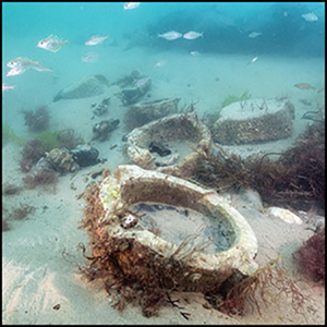
Mortars
Mortars were one of the most important utensils in the medieval kitchen, where they were used for the creation of “the smooth sauces and pastes that were the hallmark of medieval upper-class cuisine” arising from the belief that “foodstuff in granular or powder form” would be more effectively absorbed by the body (Adamson Reference Adamson2004: 62). Purbeck marble mortars have been found in medieval contexts throughout England and as far afield as Belgium (Vlaams Instituut 2009) and Denmark (Bencard Reference Bencard1971), with a recent study showing that nearly half of the known archaeological mortars reported in England are made of Purbeck stone (Jervis Reference Jervis2022). Mortars of the type found on the wreck are generally from mid-thirteenth- to fourteenth-century contexts and the tooling and design are thought to have developed as a sideline of the decorative stone industry of Purbeck (Dunning Reference Dunning1961).
The categorisation of medieval mortars began with Dunning (Reference Dunning1961) and was further refined by Biddle (Reference Biddle1990) and Horsey (Reference Horsey1992). These categories sought to organise the mortars by material followed by form or finish. Small sample sizes, mixed contexts and incomplete artefacts hamper the established classification systems, whereas the assemblage from the wreck is from a single context and contains mortars that vary in form and size and are mostly undamaged. Thus, there is the potential to improve the classification systems. Despite the superficial differences between the mortars on the wreck (Figure 9), they fit the pecked mortars of Biddle's (1990) classification, with straight-sided bowls, diagonal tooling on the interior, a band of vertical or diagonal tooling around the rim and base, and a pecked finish between the bands. The mortars all feature two ribs on opposing sides to serve as handles and two lugs, one featuring a runnel.

Figure 9. The five mortars recovered from the wreck (figure by author).
Crew
Food and drink are the fuel of a sailing vessel, but very little is known about the victualling of the crew or how they lived on board in the thirteenth century. Inventories for a series of galleys built for Edward I in 1295 do note cooking equipment, including cauldrons (Friel Reference Friel1995: 116), but it is generally thought that cooking would have been done onshore during this time period to avoid having a fire on board the vessel. Several contemporary medieval manuscripts feature a common theme of sailors setting up camp on the backs of whales (Figure 7). Yet the 1295 galleys carried iron griddles, and references to ovens in the fourteenth century are known (Friel Reference Friel1995: 118).
Two copper-alloy cooking vessels were recovered from the Mortar Wreck: a cauldron and a posnet (a small cauldron with a long handle) (Figure 3). Both appear to be loam cast with elements of the casting process clearly visible. Both are also in the classic tripod form with the handles perpendicular to the flash line and one leg in line with the handle. The manufacture of vessels of this type did not tend to occur in England until the mid-fourteenth century, and the form of the pots suggests that they are of north-west European origin (Butler & Green Reference Butler and Green2003).
As a result of its deposition on the seabed, the posnet is significantly corroded on one side and is missing part of the rim, one leg and the handle. The vessel has a rim diameter of approximately 145mm and the bowl is 160mm deep. The posnet does not appear to feature any decorations and has a large round sprue (channel for molten metal when item was cast) in 47mm in diameter.
The cauldron is near complete with only a large dent in the side, likely to have occurred during the wrecking process, and with a rim diameter of approximately 230mm and a depth of bowl of 220mm. The cauldron's legs are triangular in form, with the two legs not in line with the handles being noticeably shorter than the third leg. It is thought that when originally cast, the legs of the cauldron would have been fully formed like the legs on the posnet. Corrosion of the legs on medieval copper-alloy cooking vessels is a common occurrence due to the presence of too much lead in the alloy, allowing the metal to soften when heated. This, combined with heavy use, perhaps over 50 years, resulted in the deformities observed on the artefacts (Roderick Butler, pers. comm.).
A third artefact recovered from the site is a thin iron dome with a hole at the apex (Figure 3, bottom right). It has a similar dimeter to the posnet, which sits comfortably on top of the artefact, suggesting that it is a sort of brazier for cooking onboard. A fourth artefact still on the seabed is a triangular concretion that may be a Brandreth, a type of stand for the cauldron.
The only evidence found at the site, so far, as to what the crew may have been eating is a heavily degraded cattle leg bone, trapped within a concretion.
Discussion
Shipwrecks are an important archaeological resource; they form a single-context site and, as such, they are often described as time capsules, providing insights into particular periods and trades that are not available from other archaeological sites or historical sources. Ships were, and are, a pinnacle of human engineering; by studying the remains of the Mortar Wreck, we can learn more about technology and trade in the thirteenth century, as well as the activities of sailors and traders, their lives and environment.
It is thought that nearly every English church of any size built between 1170 and 1350 incorporated Purbeck stone (Knoop & Jones Reference Knoop and Jones1938), with the golden age of Purbeck Marble in the last 100 years of that period. The ship was operating at the very start of the period, when historic records show that building projects such as Westminster Abbey were buying shiploads of marble between 1256 and 1257 from Corfe (Pipe Roll 52 Henry III). Although it is known that the stone was transported by sea, the logistics and fine details of such shipments are lost to history.
The Mortar Wreck opens new channels of investigation and interpretation into the logistics and livelihoods of the thirteenth century, a relatively poorly understood period of history. A full excavation of this internationally important site is vital to provide a better picture of the ship, its cargo and the wider world of medieval ships and shipping.
Conclusions
The vessel that forms the Mortar Wreck is a large mid-thirteenth-century cargo ship, outbound from Poole Harbour, taking building stone and partially finished high-status goods from the local quarries at the height of the Purbeck marble industry. It is not currently possible to determine the port that the ship was destined for, but it is clear from the distribution patterns of Purbeck marble artefacts that a large trading network existed at that time. The fact that the grave slabs observed on the wreck were not polished suggests that the vessel could have been travelling to a large construction project where the slabs would have had polishers on site, or perhaps to London stone workshops. It is also possible that a marbler may have been onboard the vessel travelling with their goods to finish them on location. Other cargo known to be exported from the Poole Harbour area, including beans, fish, wool, plaster, lime and oyster shells (Hinton Reference Hinton and Hinton2002) may have been aboard the ship, but as these are all perishable or bouyant, no traces survive and only the heavy, robust goods are left on the seabed.
Acknowledgements
I would like to thank everybody who has put their time and effort into getting the project to its current stage, especially the Bournemouth University team of archaeologists, divers and fundraisers. I am also grateful for the assistance of members of the following organisations: The Antique Metalware Society; The Church Monuments Society; DendroArch; Maritime Archaeological Sea Trust; Poole Harbour Commissioners; Poole Museum; the Purbeck Marblers; and Rocket Charters.
Funding statement
The majority of the work on the site has been funded from private donations via Bournemouth University's fundraising team. Historic England have provided additional funds.


 Open access