
We introduce here the concept of the Anthropocene as a potential geological unit of time, while noting that antecedents of this concept were sporadically present in previous literature prior to its effective inception, by Paul Crutzen, in 2000 CE. We describe how the Anthropocene compares with examples from the Geological Time Scale throughout Earth history, and demonstrate the extent to which the term has practical utility in the field of geology, in the field of natural science generally, and to the wider academic community. In this book we describe the geological Anthropocene, while this definition does not exclude other, different, interpretations of the Anthropocene that have appeared in recent years amongst other scholarly communities, particularly in the humanities. We explain here how this book will help to inform the process of producing a formal proposal for the Anthropocene as a geological time unit. Examples from the beginning of the Cenozoic Era, the Cambrian, Silurian and Quaternary periods, and the Eocene and Holocene epochs are used to demonstrate how chronostratigraphic boundaries are defined and what lessons from these can be applied to defining the Anthropocene.
1.1 A General Introduction to the Anthropocene
The Anthropocene, launched as a concept by Paul Crutzen in 2000 (Crutzen & Stoermer Reference Crutzen and Stoermer2000; Crutzen Reference Crutzen2002), has in less than two decades grown astonishingly in its range and reach amongst different academic communities. Fundamentally, it was coined to crystallise the growing realisation that human activities – or, more often, the unintended consequences of human activities – had fundamentally changed the Earth System. Hence, the patterns of behaviour of the oceans, atmosphere, land (i.e., the geosphere’s terrestrial surface), cryosphere, biosphere and climate are no longer those that over 11 millennia characterised the great bulk of the epoch that we still formally live in, the Holocene. The accent on planetary processes reflected the character of the scientific community that Paul Crutzen was working in, that of the Earth System science (ESS) community, concerned most acutely with contemporary global change.
Nevertheless, the Anthropocene was explicitly described as a geological time interval, as an epoch in direct comparison to – and different from – the Holocene because of the inferred geological significance of the altered Earth System processes. The implicit hypothesis was that the Holocene had terminated, perhaps about when the Industrial Revolution started. This improvised proposal chimed with the conclusions on the nature, scale and speed of global change being reached by the ESS community, and the term soon began to be widely used in publications, matter-of-factly, as if it were already part of accepted geological time terminology. It was not formal, though, having gone through none of the extensive formal analysis, debate, agreement (via an established pattern of voting amongst appropriate stratigraphic bodies) and ratification that formal geological time terms require (and which are described fully in Section 7.8.1).
A few years after Crutzen’s intervention, increasing use of the term began to be noticed by the geological community, and a preliminary analysis by a national body, the Stratigraphy Commission of the Geological Society of London, suggested that the term had merit and should be studied further with respect to any potential formalisation. This conclusion was in sharp contrast to the general response by the geological community to sporadic earlier suggestions of a ‘human era’, which had indeed been made since the late 18th century (Stoppani Reference Stoppani1873; Buffon Reference Buffon, Zalasiewicz, Milon and Zalasiewicz2018). These suggestions had always been generally rejected, on the basis that the great forces of nature that drove Earth’s geology were considered to operate on a vaster and longer-term scale than any kind of human impact, which by comparison was widely considered ‘too puny’. The realisation, even amongst geologists, that humans could indeed significantly affect not only the Earth System parameters but, as a consequence of this, also the course of Earth’s geological evolution, led to an invitation from the Subcommission of Quaternary Stratigraphy (SQS) of the International Commission on Stratigraphy (ICS) to set up a formal Anthropocene Working Group (AWG); to examine the case for formalisation; and ultimately to make recommendations to the SQS, ICS and the latter’s parent body, the International Union of Geological Sciences (IUGS).
This book is the outcome of the work of the Anthropocene Working Group since 2009 in developing and testing the general case for the Anthropocene as a formal geological time unit. This work was a necessary prelude to preparing any specific formalisation proposal to the SQS, ICS and IUGS (a task that is underway). It summarises the evidence gathered in the intervening time, both by AWG members and others, for what we may here call the ‘geological Anthropocene’ or perhaps ‘stratigraphic Anthropocene’. This distinguishes it from other interpretations of the Anthropocene that have emerged in these last few years as a range of communities, including those within the social sciences, humanities and arts, have explored this term and concept through the prisms of their own disciplines.
Thus, in our discussions of the Anthropocene to follow, there are a few things to bear in mind. Firstly, its interpretation here is non-exclusive – it does not in any way restrict (or seek to restrict) the potential use of the word in other meanings, by other communities, as has indeed been the case in the last decade (e.g., Edgeworth et al. Reference Edgeworth, Richter and Waters2015; Ruddiman et al. Reference Ruddiman, Ellis, Kaplan and Fuller2015a). Many words have more than one meaning – the word ‘mantle’, for instance, can be applied to part of the Earth beneath the crust, to an item of clothing, to a type of tissue on a mollusc or to part of an old-fashioned gas lamp. Sometimes the meaning of the word is clear from the context, and sometimes an appropriate qualifier needs to be used to ensure precision of communication; we suggest that such care in communication now needs to apply to the term ‘Anthropocene’ too.
We recognise that accepting the various material signals of the geological Anthropocene as a valid scientific outcome of stratigraphic analysis may lead, as a corollary, to analysis of the societal, cultural and political causes and consequences of the existence of a geological Anthropocene. Such a broader level of analysis is potentially of considerable importance and would involve extensive cooperation of the sciences, the humanities, the arts and society. However, it goes beyond the mandate of the Anthropocene Working Group and the scope of this book. One might use a medical metaphor, in that the characterisation and definition of a geological Anthropocene may be said to be diagnosing the condition of a planet through a particular set of symptoms, against the background of a very long family history. Such analysis of the geological Anthropocene does not, though, investigate the causes of the condition too deeply, nor does it offer any treatment plan or much in the way of a prognosis.
In a geological context, the Anthropocene is here considered as a unit of Earth history and, more than this, as a potentially formal unit that might become part of the ICS-produced International Chronostratigraphic Chart (which informs the Geological Time Scale). It would thus comprise a potential Anthropocene Epoch and, as its essential material counterpart and alter ego, simultaneously an Anthropocene Series, which is a unit of strata that can be dug into, sampled and – in a few cases, despite its geological youth – hit with a hammer. The value of such a designation is to make the most effective comparison between present processes and those of the deep geological past: to, as far as possible, compare like with like in making such comparisons. As the history of the Earth prior to human documentation can only be inferred from the rock record, this focus on material, stratal evidence is critical to comparing the modern and ancient histories of this planet and therefore to gauging the relative scale and rate of human-driven perturbation. The geological Anthropocene, therefore, has to be considered within the established rules and guidelines that apply to all other units of the Geological Time Scale. For instance, it is important that, as far as possible, its beginning (and its base, when applied to strata) is synchronous around the world (see Section 7.8).
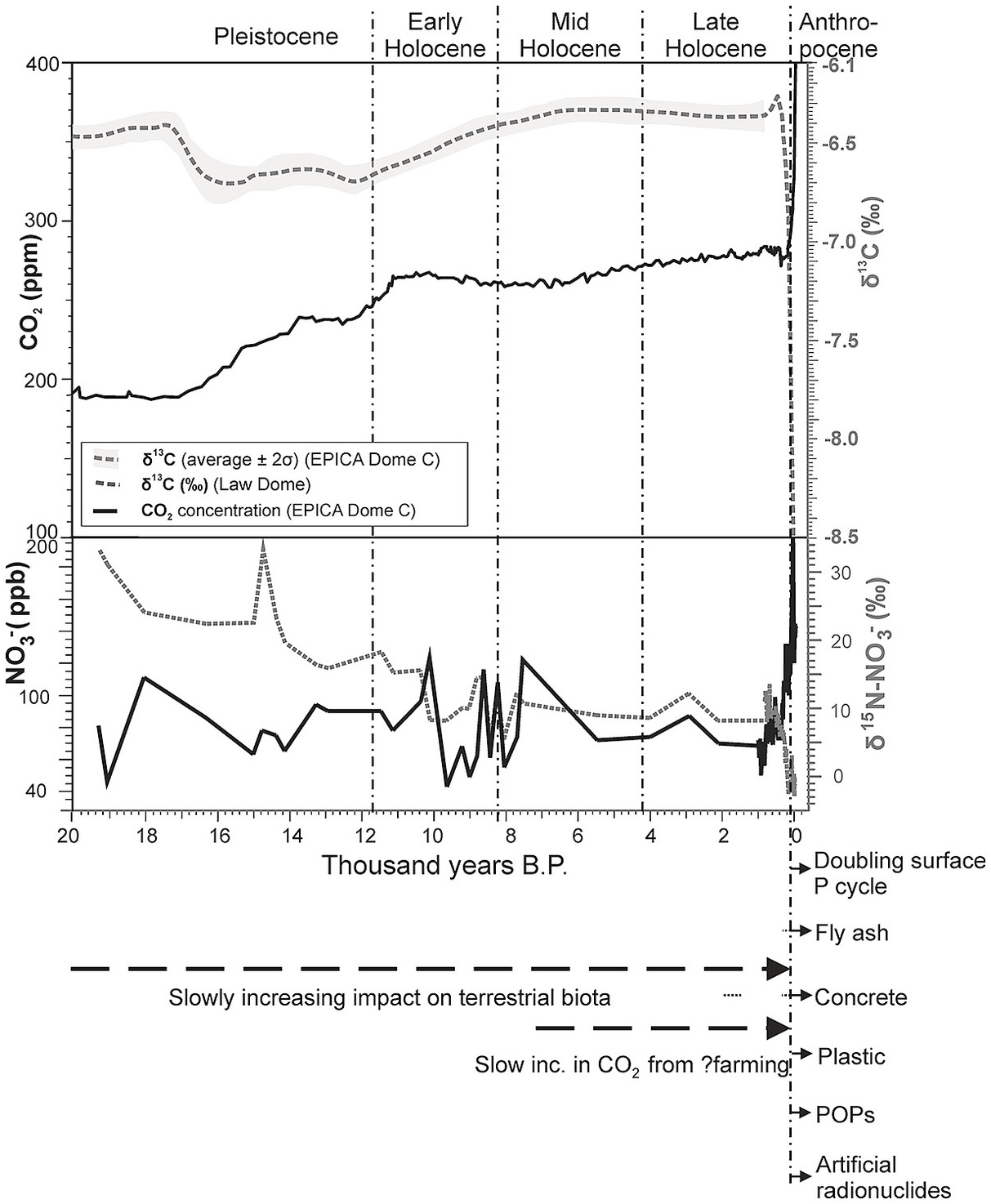
The geological Anthropocene is not a diachronous unit of human cultural history like the Iron Age and Palaeolithic, which unfolded in mosaic fashion across the planet, or like the Renaissance (though other social science interpretations of the Anthropocene may approximate to such units). More generally, descriptions of it as a ‘human epoch’ are in some respects misleading. The Anthropocene is here considered as an epoch of Earth time, just like all Earth’s previous epochs. It so happens that its distinctive characteristics have up until now been driven largely by a variety of human actions. But if these characteristics (such as sharply increased atmospheric carbon dioxide levels, global carbon isotope and nitrogen isotope anomalies, a biosphere modified by species extinctions and invasions, and so on – Figure 1.1.1) were driven by any other means – such as by a meteorite impact, volcanic eruptions or the actions of another species – then they would have exactly the same importance geologically.

Figure 1.1.1 Trends in key stratigraphic indicators from the Late Pleistocene to the present time. Note the largely gradual change (at this scale) across the Pleistocene-Holocene boundary, the general stability through the Holocene, and the marked inflections and incoming of novel indicators that clearly demarcate a changed trajectory from the mid-20th century, identified as the Anthropocene.
Therefore, setting out these preliminary constraints of what we consider the stratigraphic Anthropocene to be and also not to be (constraints that are placed upon all of the units of the Geological Time Scale) helps explain the particular content and emphases that we place in this book. The Anthropocene represents a remarkable episode in the history of the Earth, a narrative that is unfinished but that has emphatically begun, and one that is of no little consequence for present and future communities. Examining it in classical geological terms will, we hope, be useful to geologists and non-geologists alike.
1.2 History of the Anthropocene Concept
Is the modern scientific concept of the Anthropocene an old idea, dating back a century or more yet retaining its meaning and perspective? Or is it a new, paradigm-shifting conceptual novelty? This question is rendered more complicated by the diversity of the perspectives from which the Anthropocene and related ideas have been addressed, their varied interpretations and the problems inherent in making historical retrospectives (e.g., Uhrqvist & Linnér Reference Uhrqvist and Linnér2015).
The notion that collective human action (or ‘mankind’, in older parlance) is a geomorphological and geological agent altering the Earth is certainly not new in Western thought (Glacken Reference Glacken and Thomas1956), with ideas developed by such thinkers as René Descartes and Francis Bacon around the domination or transformation of nature by humankind. But the extent to which this notion has been embedded within a context of geological and biospheric processes and deep-time Earth history – and, more specifically, in the stratigraphic nomenclature for classifying Earth history – has varied, as has scientific appreciation of our home planet as a specific and remarkable element within the solar system. The history, and indeed prehistory, of the Anthropocene concept and related ideas is still an emerging and debated topic, but it has received attention after Crutzen’s (Reference Crutzen2002) early suggestions of historical antecedents in both concise (e.g., Steffen et al. Reference Steffen, Grinevald, Crutzen and McNeill2011) and more comprehensive (Grinevald Reference Grinevald2007; Davis Reference Davis2011) accounts.
An in-depth study has yet to be written. The history of science and the development of knowledge are connected in intricate and reciprocal ways, so the appearance of a conceptual novelty and new scientific terminology is often bedevilled by misunderstanding. The new ‘big idea’ of the Anthropocene, as first coined by Paul Crutzen and Eugene Stoermer (Reference Crutzen and Stoermer2000) in the context of the IGBP (International Geosphere-Biosphere Programme) and by Crutzen (Reference Crutzen2002) and then considered by Zalasiewicz et al. (Reference Zalasiewicz, Williams and Smith2008) in the geological context of stratigraphy, is no exception (Hamilton & Grinevald Reference Hamilton and Grinevald2015).
The ancients sometimes pondered how humans relate to their world, as in Lucretius’ suggestion of an Earth made weary through the weight of a growing human population. But perhaps the first significant reference in the Western world is within an influential work in which the Earth’s history was, for the first time, systematically chronologically described on the basis of empirical geological evidence. This is Buffon’s Les Époques de la Nature, published in 1778 (Roger Reference Roger1962; Buffon Reference Buffon, Zalasiewicz, Milon and Zalasiewicz2018; see also Heringman Reference Heringman2015). In this pioneering book, the seven ‘epochs’ represent distinct phases in Earth history, ranging from its initial cooling to the formation of the oceans and the lowering of sea level, the weathering of primordial rocks and the deposition of sedimentary strata, and the origin and progression of successive, different forms of life. The ‘seventh and last epoch – When the power of Man assisted the operation of nature’ is described as one in which humans not only are present but, as ‘civilised humans’ (placed by Buffon in overt opposition to ‘savages’), are modifying key Earth processes such as regional temperature and precipitation by altering vegetation patterns and burning coal. In attempting to describe how key planetary mechanisms (crust formation, sea level, volcanism and so on) might be interlinked and how they can evolve through time, Buffon was a pioneer of Earth history, and the late (in Buffon’s chronology) addition of human participation in Earth history is placed within this same intellectual framework. Buffon, like James Hutton, Joseph Black, Adam Smith and James Watt, was a natural philosopher of pre-industrial Europe, a man of the ‘Age of Enlightenment’ and one of many thinkers considering the place of humans in Earth history (see Rudwick Reference Rudwick2005, Reference Rudwick2008).
The idea of ‘man’ as a geographical and geological agent arose in a succession of geological and related naturalist publications in the mid- to late 19th century. The Welsh geologist and theologian Thomas Jenkyn (Reference Jenkyn1854a, Reference Jenkynb; mentioned by Lewis & Maslin Reference Lewis and Maslin2015) also wrote of a ‘human epoch’ that he referred to as an ‘Anthropozoic’ that would leave a future fossil record. The term Anthropozoic was also used by Haughton (Reference Haughton1865) and the Italian abbot and geologist Stoppani (Reference Stoppani1873; quoted by the US ambassador in Italy; Marsh Reference Marsh1874) and was rediscovered by William Clark in the 1980s (Clark Reference Clark, Clark and Munn1986, quoted by Crutzen). Stoppani observed that humans, since the rise of Christianity, were changing not only the present but also the future of the Earth. The roles of humans and environmental change in the geology of the recent past were later to be conflated with the classification of geologically recent strata as the Holocene (a term proposed to replace Lyell’s ‘Recent’ by Paul Gervais in the 1860s and adopted after the Third International Geological Congress of 1885), in which the geologically defining forces were seen to be marked by post-Pleistocene glacial warming and sea-level rise, but in which it was recognised that locally abundant human activities and traces formed part of the characterisation.
The entire Quaternary Period (Gibbard & Head Reference Gibbard and Head2009), broadly representing the Ice Ages (see Section 1.3.1.5), was recognised as the time when the human genus diversified (albeit mostly remaining ecologically and geologically insignificant) and was termed the Anthropogene (sometimes transcribed as Anthropocene) by some early- to mid-20th-century Soviet geologists and geochemists. While the Anthropogene was essentially a synonym for the Quaternary (Gerasimov Reference Gerasimov1979), Piruzyan et al. (Reference Piruzyan, Malenkov, Barenboim and Precoda1980; quoted in Grinevald Reference Grinevald2007) noted the following:
The notion that mankind was becoming a power of geological scale was, by the beginning of the 20th century, clearly expressed by A. P. Pavlov in Moscow and, independently, by C. Schuchert in New Haven. They interpreted in a new way long-known facts on the changes in the environment caused by human activities, coming to the conclusion that their manifestations characterised the beginning of a new geological era. Ideas on the new geological era – ‘Psychozoic’ according to Schuchert, ‘anthropozoic’ according to Pavlov – were developed in detail by V. I. Vernadsky.
A focus on the changes that humans specifically were making had been first documented by George Perkins Marsh in his classic book Man and Nature (Reference Marsh1864), which was retitled as The Earth as Modified by Human Action in the second edition of 1874. Marsh’s study was couched in environmental or geographical rather than geological (or stratigraphic) terms, reflecting his posthumous status as ‘North America’s first conservationist’ or ‘Prophet of Conservation’ (Lowenthal Reference Lowenthal2000). But his themes and influence were overtly restated and examined in later meetings and publications (Thomas Reference Thomas1956; Nir Reference Nir1983; Orio & Botkin Reference Orio and Botkin1986; Turner et al. Reference Turner, Clark and Kates1990; Naredo & Gutiérrez Reference Naredo and Gutiérrez2005). A classically geological analysis by Sherlock (Reference Sherlock1922) systematically documented the lithostratigraphic dimension driven by mining, building and related activities, assembling statistics on different types of mineral production and rock and earth movement and considering not only the effects in sedimentological and geomorphological terms but also geochemical effects, not least following Arrhenius (see the next paragraph) in linking coal burning to previsaged climate warming (see also Shaler Reference Shaler1905).
While Marsh and others, including Thomas Jefferson, had realised that human changes to Earth’s plant cover led to changes in the temperature of the air, John Tyndall had demonstrated in the 1860s that the minor gases of the air, like water vapour, carbon dioxide, methane and ozone, had the power to absorb and re-emit long-wave radiation, meaning that fluctuations in their abundance could change the climate (Tyndall Reference Tyndall1868). Arrhenius had calculated 30 years later that doubling the amount of CO2 in the air would warm the planet by about 6°C (Arrhenius Reference Arrhenius1896). By 1908 he had modified that figure to 4°C and noted that the burning of coal by industry would emit enough CO2 to measurably warm the atmosphere (Arrhenius Reference Arrhenius1908). He thought that would be no bad thing – humans would benefit from living in a warmer, more equable climate, and rising warmth and CO2 would stimulate plant growth, providing more food for a larger population and even preventing the occurrence of another glacial period. This kind of human impact on the planet was well beyond that envisaged by the likes of Marsh or Sherlock. But it was not until the mid-20th century that scientists were able to build on Arrhenius’s findings and become fully aware of the growing human impact of changing atmospheric chemistry, not least because the technology to provide us with the full spectrum of CO2 in the atmosphere was not available until the mid-1950s (Plass Reference Plass1961). For more on CO2 and climate, see Section 6.1.
More or less simultaneously, influential conceptual developments under the same terms of ‘biosphere’ and ‘nöosphere’ were made by two French Catholic visionary thinkers: Pierre Teilhard de Chardin, then professor of geology, and Édouard Le Roy, a mathematician turned philosopher and Bergson’s successor at the Collège de France. Another significant contributor was the remarkable Russian geoscientist, Vladimir I. Vernadsky, a hugely influential member of the Saint Petersburg Academy of Sciences, who was then staying in Paris. The nöosphere (or anthroposphere, including the technosphere) denoted accelerating human transformation of ‘the face of the Earth’ (a term derived from the massive and widely read early-20th-century geological synthesis of Eduard Suess). These various ideas of Teilhard, Le Roy and Vernadsky generated a range of interpretations (and confusions) in subsequent years, mainly after the Second World War (WWII) and the birth of the Nuclear Age. Teilhard disagreed with Vernadsky’s meaning of the ‘biosphere’, which both took from Suess. Teilhard’s evolutionary view of life and man on Earth was ignorant of Vernadsky’s biogeochemical perspective, and he probably never read La Biosphère, the 1929 French translation of Vernadsky (1926, in Russian) – at least, he never quoted it in his writings. In general, Vernadsky’s biogeochemical teachings and his own ambitious concept of the Earth’s biosphere in the cosmos were commonly ignored (Vernadsky Reference Vernadsky, Langmuir and McMenamin1998).
The term ‘nöosphere’ was adopted by Vernadsky only after Le Roy’s books of 1927 and 1928 (Vernadsky Reference Vernadsky1945, Reference Vernadsky and Starostin1997). It was originally seen as a direct offshoot of the biosphere, a term and notion briefly coined by Suess in his 1875 book Die Entstehung der Alpen (The Origin of the Alps) and restated in 1909 in the final chapter, ‘Das Leben’ (Life), of his great work Das Antlitz der Erde (The Face of the Earth). The term ‘biosphere’ was adopted by Teilhard and Le Roy, with a restricted biological meaning, and developed in a global biogeochemical perspective by Vernadsky (1926; see Reference Vernadsky, Langmuir and McMenamin1998) to represent not just the sum total of living matter (or biota, according to Teilhard) on the Earth’s rocky crust, but an evolving complex system representing the dynamic interaction and co-evolution of life, crustal mineral matter, ocean, atmosphere and energy (mainly from the Sun). It was this geobiological system that Vernadsky viewed as being changed and perturbed by growing human activities, particularly technical and scientific development (Vernadsky Reference Vernadsky1924, Reference Vernadsky1945, Reference Vernadsky and Starostin1997).
Vernadsky’s ideas foreshadowed many of those developed by James Lovelock and Lynn Margulis (Reference Lovelock and Margulis1974) in the ‘Gaia hypothesis’, specifically that life acts together as a system to modify and regulate surface conditions on Earth. Lovelock, like most Western scientists, only became aware of Vernadsky after he had developed his own ideas (Grinevald Reference Grinevald1987, Reference Grinevald, Bunyard and Goldsmith1988). As in the case of Plass (Reference Plass1961) and the measurement of the spectrum of CO2 in Earth’s atmosphere in the 1950s, Lovelock’s Gaia concept also depended on the development of a new technology, in his case for the measurement of gases in the atmospheres of other planets, in the search for signs of life. The atmosphere of a planet with life would contain a cocktail of gases out of equilibrium with one another, much like Earth’s, while a planet without life would contain an atmosphere dominated by gases like CO2, as on Mars and Venus (Lenton Reference Lenton2016). In due course, Lynn Margulis was instrumental in the United States for the publication in New York of a first ‘complete annotated edition’ of Vernadsky’s The Biosphere (Vernadsky Reference Vernadsky, Langmuir and McMenamin1998), significantly cited by Crutzen and Stoermer (Reference Crutzen and Stoermer2000) and Crutzen (Reference Crutzen2002).
Over the 20th century, the epic scale of Earth history (e.g., Hazen et al. Reference Hazen, Papineau and Bleeker2008; Lenton & Watson Reference Lenton and Watson2011; Zalasiewicz & Williams Reference Zalasiewicz and Williams2012) was becoming progressively clearer – not just its multi-billionFootnote 1-year duration, as resolved by radiometric dating, which allowed the time necessary for the evolution of many successive life forms by Darwinian evolution, but also the profound nature of geological change. The plate tectonics revolution (Oreskes Reference Oreskes1999; Oreskes Reference Oreskes2003) showed that even ocean basins and mountain ranges were ephemeral features on a planetary timescale, while detailed geological studies showed that rare, extraordinary volcanic outbursts (far greater than anything in recorded human history) and meteorite impacts could fundamentally perturb the Earth System and lead to mass extinctions. Geologists also came to understand that the evidence of the last few million years, of the Ice Ages, revealed that present-day temperate landscapes were formerly buried under kilometre-thick sheets of ice, while global sea-level changes reached amplitudes of ~130 m, roughly twice the amount of sea-level rise that would happen if all of the Earth’s present ice were melted (see Chapter 6 for a fuller discussion).
Small wonder that, until recently, the great majority of geologists thought human impact on the geology of the planet (if they thought of it at all) to be trivial and fleeting by comparison with these more obvious large-scale geological events. Collations of the physical impact on the Earth’s geology (in terms of such things as volumes of raw material excavated) by such as Sherlock (Reference Sherlock1922) were impressive, but the resulting constructions were generally regarded as temporary, easily erodible structures that (once humans were no longer present) would simply be recycled back into the Earth by processes of erosion and sedimentation. There was also a tendency to regard geology as ending as human history began and giving way to disciplines such as anthropology, archaeology and written history (cf. Finney Reference Finney, Waters, Zalasiewicz and Williams2014).
One might take the opinions of the influential North American geologist Edward Wilber Berry (Reference Berry1925) on the Psychozoic as typical of widely held opinion in the international geological community through much of the 20th century. While admitting the ‘magnitude and multifarious effects of human activity’, he said that these were ‘scarcely of geological magnitude’ and that the Psychozoic was ‘not only a false assumption, but altogether wrong in principle, and is really nurtured as a surviving or atavistic idea from the holocentric philosophy of the Middle Ages’.
Widespread acceptance that humans could profoundly alter the course of the Earth’s geological evolution – and that geology (particularly stratigraphy) as a discipline reached into the present – emerged only slowly and fitfully, in the post-WWII years. Significant change in opinion was associated with such developments as the emergence of Earth System science, closely associated with the development of atmospheric science and the rise of biogeochemistry, and the ambitious International Geosphere-Biosphere Programme (IGBP) in the later part of the 20th century (see the ‘Reflections on Earth System Science’ by IGBP’s leaders published in Global Change, Rosswall et al. Reference Rosswall, Liss and Rapley2015). These had built on earlier developments in the post-WWII years. Fairfield Osborn’s book Our Plundered Planet wrote of ‘man as now becoming for the first time a large-scale geological force’ (Osborn Reference Osborn1948, p. 29) and included a chapter on this theme, with explicit reference to Vernadsky’s work. The role of the early debate on the first Meadows report to the Club of Rome, The Limits to Growth (see Georgescu-Roegen Reference Georgescu-Roegen1975), was significant here, too, as illustrated by the emergence of Georgescu-Roegen’s bioeconomic paradigm, in which he suggested that natural resources are irreversibly degraded once they are exploited in economic activity, and in which he developed concepts of ecological economics and industrial ecology.
These developments led to a growing appreciation of human impact (e.g., Turner et al. Reference Turner, Clark and Kates1990), not so much upon the physical structures of the planet but rather on its chemical and biological fabric, with such phenomena as climate change and biodiversity loss coming to the fore. As a further factor, both the United States and the USSR started paying much more attention to the ‘environment’ as a theatre of warfare and pouring large amounts of funding into atmospheric and oceanic sciences. Given that such processes could be geologically long-lived (as regards climate change) or even permanent (as regards species extinctions), realisation grew of the scale and potentially lasting nature of human-driven perturbations.
Suggestions of ‘geological’ terms to describe this global change reappeared. Andrew Revkin published the term ‘Anthrocene’ in a 1992 book on global warming (Revkin Reference Revkin1992). The biologist Michael Samways (Reference Samways1999) coined the term ‘Homogenocene’ to encompass the increasing global homogenisation of animal and plant communities through widespread species invasions. The oceanographer Daniel Pauly (Reference Pauly2010) came up with the term ‘Myxocene’ to describe his projection of future oceans dominated by jellyfish and microbial slime.
However, it was the term Anthropocene that began to take hold, initially within the Earth System science community. In February 2000, the term was offered on the spur of the moment by Paul Crutzen, the Nobel Prize–winning atmospheric chemist, at a meeting of the IGBP Scientific Committee in Cuernavaca, Mexico. Becoming progressively impatient at discussion of global change in the Holocene, he broke into the discussion, saying that we were no longer in the Holocene but in (and here he improvised) … the Anthropocene. Part of the rest of the meeting was taken in discussion of this idea; afterwards, Crutzen researched the term, found that it had been used for some years informally by a lake ecologist, Eugene Stoermer, and invited him to join him in publishing the term (though the two men never met). It was published in 2000, in the IGBP Newsletter; the article was invited and edited by IGBP executive director and newsletter editor Will Steffen, who had been present at the Mexico meeting. Two years later, Crutzen published a brief, vivid one-page article on the term in Nature in 2002, which gave the term wide visibility. He suggested that the Anthropocene began with the Industrial Revolution.
Continued research within the IGBP community led to the recognition that the time since ~1950 CE has without doubt seen the most rapid transformation of the human relationship with the natural world in the history of humankind (Steffen et al. Reference Steffen, Sanderson and Tyson2004). At a 2005 Dahlem Conference on the history of the human-environment relationship, in which Crutzen participated, the sharp upward inflection of many trends of global significance in the mid-20th century was recognised as the ‘Great Acceleration’ (Hibbard et al. Reference Hibbard, Crutzen, Lambin, Costanza, Graumlich and Steffen2006). That term was first used in a journal article in 2007 (Steffen et al. Reference Steffen, Crutzen and McNeill2007), in which it was regarded as a ‘second stage’ of the Anthropocene, following the Industrial Revolution.
The term Anthropocene began to be widely used and further analysed, particularly within the IGBP-based community (e.g., Steffen et al. Reference Steffen, Sanderson and Tyson2004). In publications, the term began to be used as if it were a formal part of the Geological Time Scale, without inverted commas or other such qualifications – but it was not formal, and to this time it remains informal.
In response to the growing visibility and use of the term, the Stratigraphy Commission of the Geological Society of London considered the Anthropocene as a potential addition to the Geological Time Scale. Although it is a national body, not an international one, and has no power of formalisation, it published a discussion paper (Zalasiewicz et al. Reference Zalasiewicz, Williams and Smith2008) signed by a majority of commission members (21 out of 22) suggesting that there was geological evidence to support the term and that it should be examined further with respect to potential formalisation.
There followed an invitation from the Subcommission on Quaternary Stratigraphy, a component body of the International Commission on Stratigraphy (the body responsible for maintaining the Geological Time Scale, more technically known as the International Chronostratigraphic Chart), to set up an Anthropocene Working Group (AWG) to examine the case for formalisation. The AWG has been working since 2009 and has published two volumes of evidence (Williams et al. Reference Williams, Zalasiewicz, Haywood and Ellis2011; Waters et al. Reference Waters, Zalasiewicz and Williams2014), together with a number of individual papers on particular aspects (e.g., Edgeworth et al. Reference Edgeworth, Richter and Waters2015; Waters et al. Reference Hancock, Spady and Soskolne2015, Reference Waters, Zalasiewicz and Summerhayes2016, Reference Waters, Zalasiewicz and Summerhayes2018), as well as responses to emerging critiques of the Anthropocene from both the stratigraphic (Zalasiewicz et al. Reference Zalasiewicz, Waters and Wolfe2017d and references therein) and other communities (e.g., Zalasiewicz et al. Reference Zalasiewicz, Waters and Head2018). This book represents a summary of these and related studies on the Anthropocene.
The AWG process was (and remains) in many ways novel as regards the assessment and determination of stratigraphic units – particularly in view of its inverted sequence of evidence and deductions (Barnosky Reference Barnosky, Waters, Zalasiewicz and Williams2014). Instead of stratigraphic names (such as the Cambrian, Cretaceous and so on) emerging from prolonged study of ancient strata, the Anthropocene Working Group was considering a concept that had emerged from another (albeit related) field of science and then determining whether it could work in both geohistorical terms (for example, as an Anthropocene Epoch) and stratal terms (to enable a time-based material unit of strata – an Anthropocene Series – to be recognised and correlated across the Earth) (see Section 1.3 for explanation of this distinction). The group also had to consider human phenomena and timescales as well as non-human, geological ones – and hence needed to include representatives of archaeology, ecology, oceanography, history, law and so on. There was also the matter of the very short timescale as compared with the million-year-scale units normally considered by stratigraphers (although the establishment of the Holocene had already provided an epoch-scale unit measured in centuries and millennia rather than in millions of years).
The stratigraphic examination of the Anthropocene has taken place in tandem with its exploration as a key concept by a wide variety of other disciplines, many from outside the Earth sciences and including the social sciences, humanities and arts (e.g., Hansen Reference Hansen2013; Chakrabarty Reference Chakrabarty2014; Davies & Turpin Reference Davis and Turpin2015; Latour Reference Latour2015; Angus Reference Angus2016; Bonneuil & Fressoz Reference Bonneuil, Fressoz and Fernbach2016; Davis Reference Davies2016; McNeill & Engelke Reference McNeill and Engelke2016; Clark & Yusoff Reference Clark and Yusoff2017; Hamilton Reference Hamilton2017; see also McNeill Reference McNeill2001). The Anthropocene has been seen both as providing some measure of, and deep-time context to, human ‘environmental’ change to the planet and as integrating the effects of a wide variety of environmental change that are commonly considered more or less separately (such as climate change, biodiversity loss, ocean acidification). That integration is made via extension of the use of the ‘multi-proxy’ approach typical of modern stratigraphic studies, and it may be related to such compilations of global environmental change as in the ‘indicator graphs’ of Steffen et al. (Reference Steffen, Crutzen and McNeill2007, Reference Steffen, Broadgate and Deutsch2015) and the planetary boundaries concept (Rockström et al. Reference Rockström, Steffen and Noone2009; Steffen et al. Reference Steffen, Leinfelder and Zalasiewicz2016).
Following several years’ work, the AWG provided its initial findings and recommendations to the 2016 International Geological Congress held at Cape Town (Zalasiewicz et al. Reference Zalasiewicz, Waters and Wolfe2017d). It found, overall, that the Anthropocene possesses geological reality consistent with a potential formal time unit and that a proposal towards formalisation should be made, at the hierarchical level of epoch/series with a boundary to be defined by a GSSP (Global Boundary Stratotype Section and Point) at some level at or around the mid-20th century (Wolfe et al. Reference Wolfe, Hobbs and Birks2013; Steffen et al. Reference Steffen, Broadgate and Deutsch2015; Zalasiewicz et al. Reference Zalasiewicz, Waters and Williams2015b; Waters et al. Reference Waters, Zalasiewicz and Summerhayes2016). ‘Bomb test’ radionuclides were suggested as the primary marker.
Support for formalisation has not been unanimous within the stratigraphic community, and detailed and searching questions have been asked as to whether it is appropriate to consider a unit so geologically brief and with so many novel features as a part of the Geological Time Scale (e.g., Finney Reference Finney, Waters, Zalasiewicz and Williams2014; Gibbard & Walker Reference Gibbard, Walker, Waters, Zalasiewicz and Williams2014; Smil Reference Smil2015; Finney & Edwards Reference Finney and Edwards2016; for responses see Zalasiewicz et al. Reference Zalasiewicz, Waters and Wolfe2017d). And there have been suggestions that the Anthropocene should not be defined in geological terms but should become a term of the social sciences – or be suppressed because it is inappropriate to other disciplines (Ellis et al. 2017; Bauer & Ellis Reference Bauer and Ellis2018; for responses see Zalasiewicz et al. Reference Zalasiewicz, Waters and Head2017b; Zalasiewicz et al. Reference Zalasiewicz, Waters and Head2018).
As these debates proceed, the current focus of the AWG is on identifying potential GSSP candidate sites within suitable kinds of sedimentary archive (such as annually laminated lake, marine or polar ice deposits; see Section 7.8 herein and Waters et al. Reference Waters, Zalasiewicz and Summerhayes2018) and also on exploring the utility of a potential formal Anthropocene unit both to the Earth sciences and to other fields of study, all in preparation for a formal proposal to the ICS. Meanwhile, the use of the Anthropocene continues to expand into areas where Earth history once did not venture. Its future status may in general be regarded as secure as regards concept but uncertain in formal terms.
1.3 Stratigraphy and the Geological Time Scale
Earth history spans in excess of 4,500 million years and so is of the order of a million times longer than recorded human history. Geologists cope in practical terms with this enormous time span by resolving the main episodes of Earth history and representing these as named units of the Geological Time ScaleFootnote 2 (Figure 1.3.1).
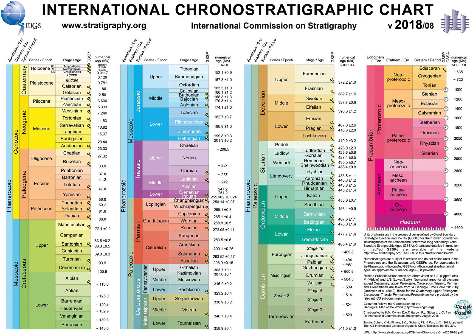
Figure 1.3.1 The Geological Time Scale of the International Commission on Stratigraphy (http://stratigraphy.org/index.php/ics-chart-timescale).
Essentially all of Earth history is gleaned from biological, chemical or physical evidence preserved in rocks, particularly within strata (because strata, being laid down successively one on top of another, can preserve a detailed record of successive events through time – and from this is derived the discipline of stratigraphy: the inference of geological history from the rock record).
The primacy of this strata-based evidence has led to there being two parallel means of classifying Earth history. There is a geochronological classification, simply of time intervals within which certain events and processes took place (for example, one might speak of the Quaternary Period in which we live, comprising the last 2.6 million years, approximately since major glaciations began occurring in both the Northern and Southern hemispheres). Together with this, there is a parallel time-based chronostratigraphic classification of the material record (i.e., of strata) that preserves the evidence of that history (thus, the Quaternary System is made up of all the strata laid down during the Quaternary Period).
The units are exactly parallel in scope, and if the definition of any of a pair of parallel units is changed, they are changed in lockstep with the other. Thus, when the Pleistocene was recently redefined to begin at 2.6 million years ago, to formally replace an older definition of 1.8 million years ago (Gibbard et al. Reference Gibbard and Head2010; and see Section 1.3.1.5), this change simultaneously affected both the Pleistocene Epoch and the Pleistocene Series. If the Anthropocene is to be defined as a formal geological time unit, as an Anthropocene Epoch, say, then that in current practice must have a material counterpart in the form of an Anthropocene Series.
The Anthropocene might be set at another rank (see discussion in Section 7.7). The Geological Time Scale is hierarchical, and smaller-scale units are grouped together into large ones (Figure 1.3.1). Thus, the largest geochronological units are eons (with eonothems as their material chronostratigraphic counterpart). We currently live in the Phanerozoic Eon, so far ~541 million years in duration, the beginning of which is tied to the emergence and diversification of metazoan organisms (see discussion in Section 1.3.1.1). Eons are divided into eras (and eonothems into erathems). We currently live in the Cenozoic Era, which began when a large meteorite strike ended (or gave the coup de grâce to, following other environmental perturbations) the Mesozoic world of non-avian dinosaurs on land and ammonites and belemnites in the seas, ~66 million years ago. Within this, we live in the Quaternary Period (often on landscapes underlain by deposits of the Quaternary System). Within the Quaternary Period, the last of many warm intervals that alternated with successive cold glacial phases is separated off (from the Pleistocene Epoch that makes up about 99.5% of the Quaternary) as the Holocene Epoch, within which we still live. The Holocene Epoch, though brief at ~11,700 years duration (see Section 1.3.1.6), is justifiable and generally unquestioned by geologists, because its deposits (of the Holocene Series) have largely formed our soils, river floodplains, deltas and coastal plains – and hence a good deal of our most fertile and productive terrains, while its deposits may be distinguished from those of previous interglacials by its rich archaeological record.
The characterisation and definition of these and other units of the Geological Time Scale are carried out not directly but as the end results of detailed study and classification of the strata by a range of stratigraphic means. Thus, the strata may be divided on the basis of their physical characters into lithostratigraphic units (bodies of rock or unconsolidated materials characterised by their lithologies and stratigraphic context). A lithostratigraphic unit may be very nearly of the same age, i.e., almost synchronous, throughout its extent: one based on a volcanic ash layer, for instance. Or it may be of substantially different ages in different places, i.e., diachronous – such as a fossilised beach deposit, progressively deposited across different parts of a landscape as sea level slowly rose or fell.
Strata (particularly those of the Phanerozoic Eon) may be divided up on the basis of the fossils they contain in the discipline of biostratigraphy. Biostratigraphic units (biozones) help establish the relative age of strata and facilitate correlation (i.e., they demonstrate age equivalence) between stratal successions in different places. They are thus proxies for time, often very good ones; but they are never perfect in this respect, because any species cannot appear (or disappear) everywhere simultaneously around the world and hence cannot define a single global time plane. Nevertheless, fossils are very often an excellent guide to a time boundary. Chapter 3 addresses the extent to which such biostratigraphic signals provide a useful means of correlating strata within the Anthropocene.
There is a variety of other means of classifying strata. One is through chemostratigraphy, exploiting different chemical patterns within strata. Particularly effective chemostratigraphic patterns are provided by ratios of stable isotopes of certain elements such as carbon and oxygen, as these may reflect global environmental changes and so can provide useful means of correlation of strata. This topic forms the basis for Chapter 5 in the context of the Anthropocene. Other correlatable patterns are provided by magnetostratigraphy, exploiting magnetic patterns preserved within rocks (see Section 2.6), notably patterns of reversals of the Earth’s magnetic field. Yet others are based on changes in global sea level (sequence stratigraphy; see Section 6.3) or upon abrupt regional or global events, most notoriously the dusting of the Earth’s surface with iridium-rich particles following the end-Mesozoic meteorite impact. Correlation is also helped by numerical calibration of such stratigraphic patterns, by means of radiometric dating or by the analysis of astronomically forced (Milankovitch) patterns in strata.
Several of these stratigraphic methods establish good to excellent correlation between stratal successions in different areas so that a detailed history of the world can be built up, with events taking place in different parts of the world being placed in their correct time order relative to each other. None of these methods provides perfect worldwide time planes (magnetic reversals come close to providing perfect time planes, though there have been none in late Quaternary time; see Section 2.6). So to provide a stable and reliable geological time framework, geologists use stable reference points within time. These are of two kinds: Global Boundary Stratotype Sections and Points (GSSPs), more commonly known as ‘golden spikes’; and Global Standard Stratigraphic Ages (GSSAs).
Global Boundary Stratotype Section and Point (GSSP): To establish a GSSP, a single level is selected within a stratal succession (Figure 1.3.2), often close to where a common and distinctive fossil first appears or where there is a marked chemical change. This level is taken to have been deposited at the instant when the time interval began (Remane et al. Reference Remane, Bassett and Cowie1996). Then geologists try to trace this level within strata all around the world, by any means possible. Importantly, the exact level chosen remains the reference point, even if the key fossil is later found to have appeared lower down in strata (i.e., earlier) at the same location (which has indeed sometimes happened; see Section 1.3.1.1). The ability to trace (i.e., to correlate) this level across the world varies greatly depending on how well the evidence is preserved in any particular case (Figure 1.3.2). For instance, in deep-ocean floor strata, the classic end-Mesozoic boundary, with its iridium-rich layer, can probably be traced to within a few millennia (in relative terms) or less. Individual tephra (volcanic ash) layers can provide similar stratigraphic resolution, as can Heinrich layers in the late Quaternary deposits of the North Atlantic, which represent debris layers dropped by sporadic iceberg ‘armadas’ (see Section 6.2.2). However, in strata that may represent, for example, desert dunes of the same general age, where the iridium dust would have been blown away, the degree of uncertainty in locating the boundary may be several million years.
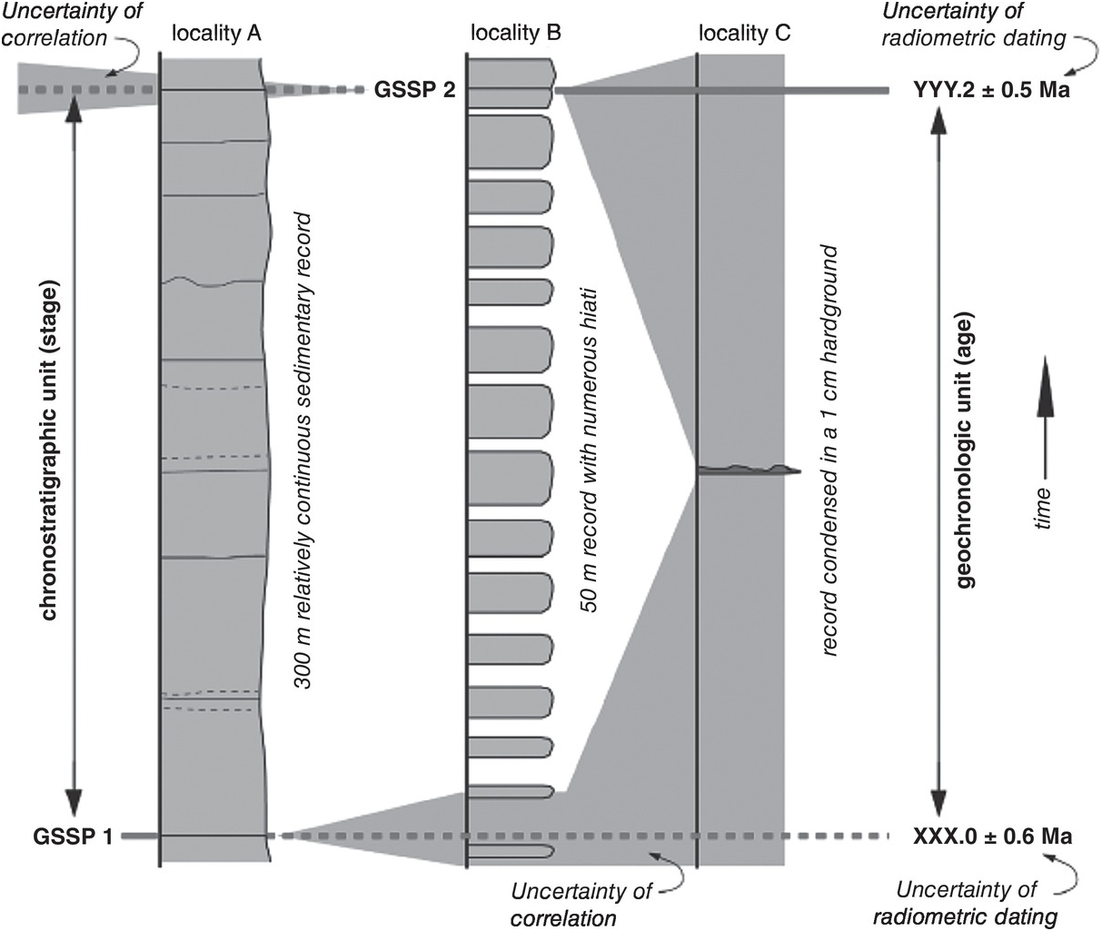
Figure 1.3.2 Diagram to illustrate GSSPs, correlation and uncertainties in correlation.
Global Standard Stratigraphic Age (GSSA): For the older stratigraphic record, where fossils are scarce rendering unambiguous correlation by means of relative dating between stratal successions more difficult, boundaries are mostly defined in terms of numerical ages (GSSAs). For instance, the boundary between the Archean and Proterozoic eons is defined at 2.5 billion years ago exactly. To locate this boundary as precisely as possible, numerical means of dating such as radiometric methods are needed (though once the boundary is located in any particular succession by this means, then it may also be traced elsewhere around the world by any type of relative dating – by chemostratigraphy, for instance). Until recently, the beginning of the Holocene was in practice taken as a GSSA (see Section 1.3.1.6), and this has also been suggested as a potential means to establish an Anthropocene beginning (Zalasiewicz et al. Reference Zalasiewicz, Waters and Williams2015b; see Section 7.8 herein).
In defining the chronostratigraphic units of the Geological Time Scale, there are some further features of importance that will be of significance to consideration of the Anthropocene. Firstly, the determination of such geological units hinges much more on effect than on cause, not least because of the importance of strata, which are the physical archives of elapsed Earth processes, in their definition. One might illustrate this with the case for the Cretaceous-Palaeogene boundary (discussed more fully in Section 1.3.1.3), where the defining iridium layer, shocked quartz and mass extinction function as effective boundary markers regardless of whether they were the result of asteroid impact or extraordinary volcanic eruption, as has been debated (Alvarez et al. Reference Alvarez, Alvarez, Asaro and Michel1984; Officer et al. Reference Officer, Hallam, Drake and Devine1987). Thus, debates about the driving forces of the Anthropocene and the role of different modes of human social, technological and political behaviour (e.g., Chakrabarty Reference Chakrabarty2014; Angus Reference Angus2016; Hamilton Reference Hamilton2017) are scientific questions of deep importance, just as are studies into the dynamics and wider effects of bolide impacts and volcanic eruptions. Yet it is the inherent pattern of strata and how well their particular characters can be recognised and correlated between different geographical places that act as the primary empirical basis for the Anthropocene as a geological unit. This is, of course, a basis that can then also help to inform scientific inquiry into the causes, processes and dynamics of the Anthropocene.
Then there is the significance of the particular name of the Anthropocene in this context. It is named after the ancient Greek term for human (anthropos) and cene, from kainos, the ancient Greek for ‘new’ or ‘recent’ time. However, as with all geological time terms (see Section 1.3.1), it has no particular significance or symbolic character – except that it is the name that has in practical terms clearly won out as regards global scientific recognition amongst the various other terms suggested for the phenomenon of a planet’s geology deeply impacted by humans – the Anthrocene (Revkin Reference Revkin1992), the Homogenocene (Samways Reference Samways1999), the Myxocene (Pauly Reference Pauly2010), the Plasticene, the Pyrocene, the Plantationocene, the Capitalocene (see Haraway Reference Haraway2015) and others, the names either reflecting a chosen part of the set of diagnostic characters or providing a suggested explanation for the causes of the epoch’s existence. The Anthropocene is a name, a practical label, just like that of other geological time units considered below, such as Silurian, Triassic and Quaternary. The Silurian was originally named after the Silures, an ancient Welsh tribe; the Triassic was named because the strata where it was first described (but by no means everywhere) are made of three main rock types; and the Quaternary is a holdover from the times of Primary, Secondary, Tertiary and Quaternary geological time units (the Primary and Secondary have long been in disuse, while the Tertiary is no longer a formal unit). Within the contexts of epochs of the Cenozoic, as denoting ‘human new’, it might be said to strike a note little different from earlier Cenozoic epochs: thus, there is the ‘old new’ (Palaeocene), an ‘early new’ (Eocene), a ‘little new’ (Oligocene), a ‘weak new’ (Miocene), a ‘more new’ (Pliocene), a ‘still more new’ (Pleistocene) and a ‘fully new’ (Holocene).
As a geological unit, therefore, attempts to ‘design’ a name that might better symbolise its essence (e.g., the Chthulucene of Haraway Reference Haraway2015) would have little significance – even if such a name could be devised and agreed upon. There is considerable congruence between the meaning of the Anthropocene as originally devised and used in the Earth System science community and the Anthropocene as considered geologically, as a chronostratigraphic unit (Steffen et al. Reference Steffen, Leinfelder and Zalasiewicz2016; Zalasiewicz et al. Reference Zalasiewicz, Steffen, Leinfelder, Clark and Yusoff2017a). This, together with the way that the name has become quickly established in the literature, suggests that the term Anthropocene should be retained with this meaning – with appropriate qualifications as needed when it is necessary to distinguish it from other meanings and interpretations of the word.
Another feature of the chronostratigraphic units concerns the definition of their beginnings (as formal time units of geochronology) and bases (as the parallel formal time-rock units of chronostratigraphy; see Section 7.8). Once it is considered that there is a need to establish a beginning/base of a unit (because there are two distinct units of time and of strata that need to be separated), then the boundary between these two units is established pragmatically, for maximum ease of recognition worldwide – that is, to allow the best correlation between the strata and the events and processes that they represent in different regions. An additional corollary is that as this is a time boundary (whether ‘abstractly’ or in rock), then this boundary must be established so that – as far as is reasonably possible – it can be placed synchronously around the world.
This need not be the case for other kinds of boundaries in geology. A boundary between rock units (of what is known in geology as lithostratigraphy) follows changes in rock properties and can commonly be markedly time transgressive – that is, it can be of different ages in different places. Even the boundaries between palaeontological zones (of biostratigraphy) – although commonly used as guides to the relative age of the enclosing strata – are in reality generally time transgressive to some degree, reflecting the time it took for assemblages of animals and plants to migrate from one part of the world to another (see Section 3.3). But the aim is for chronostratigraphic boundaries to be synchronous, to provide clear separation between what used to be known as the ‘holy trinity’ of rocks, fossils and time. The Anthropocene, if it is to be considered as a geological time unit, must follow the same pattern.
Selection of such an Anthropocene boundary would thus firstly seek maximum time-correlation potential, with less emphasis placed upon factors interpreted to have most geohistorical significance. At a few established geological time boundaries in the ancient record, the two (correlative potential and geohistorical significance) coincide – as arguably with the Cretaceous-Palaeogene boundary (see Section 1.3.1.3). Much more often there are extended boundary intervals reflecting an array of complex changes in time and space, as one Earth state – and hence one pattern of strata and fossils – gives way to another, and decisions need to be made as to which event, in such a prolonged interval, provides the best time marker (see, e.g., Zalasiewicz & Williams Reference Zalasiewicz and Williams2014; Williams et al. Reference Williams, Zalasiewicz, Waters, Landing, Waters, Zalasiewicz and Williams2014; discussed in more detail in Sections 1.3.1.1 and 1.3.1.2).
Within such a context, an effective Anthropocene boundary does not need to be based, say, on the earliest significant traces of human activity (for example, the wave of large mammal extinctions beginning in the Late Pleistocene) or even those that may be regarded as of most transformative significance (some 10,000 years ago, for instance, as agriculture started). Instead – and especially as the geological Anthropocene is in essence Earth centred (and strata based) rather than human centred – it should provide the clearest, most recognisable, most nearly synchronous geological division. The boundary, indeed, need not be based on a human-made signal. Had there been, say, a globally recognisable volcanic ash layer from some particularly violent single eruption somewhere within the boundary interval (if the 1815 Tambora event had been even larger, for instance; cf. Zalasiewicz et al. Reference Zalasiewicz, Williams and Smith2008), then that might have served admirably as a candidate boundary. Similarly, it is more important that the boundary allows the best tracing of a single time plane around the world than that it exactly coincides with the timing of greatest global change, and there are a number of boundaries of the Geological Time Scale where the two (time plane and time of greatest change) are significantly offset (e.g., Zalasiewicz & Williams Reference Zalasiewicz and Williams2014). In the case of the Anthropocene, there is in fact reasonably close congruence between the boundary considered most optimal in this volume (see Figure 1.1.1) and the change in trajectory of major parts of the Earth System (perturbations to the carbon and nitrogen cycles, for instance).
Examples from the ancient record described below present a selection of chronostratigraphic boundaries, from ancient to geologically recent. They demonstrate the kind of evidence that has been used to divide the geological column into sensible and pragmatically recognisable time units, the kind of decisions and compromises that needed to be taken, and the creativity deployed to provide a clear and unambiguous framework for navigation within a complex and variable succession of both strata and planetary history. Establishing a proper definition for the Anthropocene will need similar decisions and compromises and comparable creativity.
1.3.1 Defining Units of the Geological Time Scale: Some Examples
1.3.1.1 Beginning of the Phanerozoic Eon (and Base of the Phanerozoic Eonothem)
This is arguably the most important geological boundary on Earth. It reflects the puzzlement of, amongst others, Charles Darwin when he contemplated the difference between the very old rocks of the Earth that we now call Precambrian (now an informal term), which seemed unfossiliferous, with the younger strata above that teemed with the fossils of arthropods, molluscs, worms and many other multicellular organisms.
This geologically rapid appearance and radiation of essentially all of the many animal groups is still something of an enigma, but its course is now better understood (Erwin et al. Reference Erwin, Laflamme and Tweedt2011) – and we also know that the Precambrian rocks do in fact include fossils, representing various forms of microbe or microbial colony and, in the later Precambrian, multicellular organisms too. Nevertheless, the evolution of animals represents a state shift on Earth at a more fundamental level than just providing a range of easily visible fossils to date and correlate strata with (important though that is). Via their complex trophic networks, they fundamentally changed the cycles of carbon, phosphorus and nitrogen; by burrowing through the seafloor, they disrupted the microbial mats that had held sway for over three billion years; and by filter feeding, they cleaned the ocean waters of fine particulate organic matter, allowing their easier oxygenation (Butterfield Reference Butterfield2011). Hence, in terms of both Earth System function and stratal distinctiveness – producing bioturbated, macrofossil-bearing rocks – this is fully consistent with an eon-scale difference.
As larger-scale boundaries also define smaller-scale ones, the beginning of the Phanerozoic Eon also aligns with that of the Paleozoic Era, the Cambrian Period, the Terreneuvian Epoch and the Fortunian Age (Figure 1.3.1). The problem, though, is to pick a precise boundary.
Examined more closely, the ‘Cambrian explosion’ of animal groups appears as a complex, stepped event (Erwin et al. Reference Erwin, Laflamme and Tweedt2011; Hou et al. Reference Hou, Siveter and Siveter2017). Some 580 million years ago, enigmatic, extinct multicellular organisms called the Ediacaran biota appeared (Figure 1.3.3). These represent a novel set of metazoan morphologies that appear to have gone extinct after some 40 million years at the end of the Ediacaran Period. Some 550 million years ago, muscular wormlike organisms appeared and began leaving burrows in sediment layers. At some 549 million years ago, the earliest biomineralised (i.e., shelly) fossils are found. At ~541 million years ago, a distinctive type of burrow that has been given the name Treptichnus pedum appeared. Small shelly fossils, representing the skeletons of many metazoans, became widespread some 526 million years ago. About 521 million years ago, the trademark fossil of the Cambrian, the trilobite, appeared (Hou et al. Reference Hou, Siveter and Siveter2017). There is other evidence in strata, such as organic-walled microfossils that show changes across this interval, and there are global changes in ratios of the ‘light’ 12C and ‘heavy’ 13C isotopes of carbon, too. Which of these significant events serves best as a boundary?

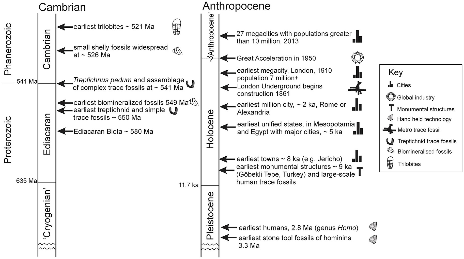
Figure 1.3.3 Cambrian boundary-related events compared with events related to a putative Anthropocene boundary;
The various possibilities were extensively debated by the working group tasked with this question. The main criterion was not which event ‘started’ this global transformation or which was deemed to be most important. Rather, it was which of them, pragmatically, provided the best time marker to enable correlation within rock strata around the world. Traditionally, the appearance of trilobites marked the boundary, but it turned out that these fossils appeared as representatives of two separate families on two separate continents (with uncertain relations between them and no common ancestor yet found), and so suggested definitions later focused more on the small shelly fossils at older levels. In 1992, the boundary was formally decided and ratified at a yet older level, with the lowest occurrence of the distinctive Treptichnus pedum burrows (Figure 1.3.3) in a stratal section at Fortune Head, in Newfoundland, coinciding with the GSSP (Landing Reference Landing1994).
Since 1992, the boundary has not proved ideal. Firstly, T. pedum was later found lower than the designated GSSP level at Fortune Head, by up to 4 m. This does not move the boundary level (that is fixed) – but it does make it more difficult to use. More problematic, just below the (revised) lowest appearance of T. pedum, there was found to be a geological fault – a tectonic dislocation of strata – that made it impossible to work out precisely how much further down T. pedum may actually range at the GSSP section. The problems with the boundary deepened when subsequent work showed not only that T. pedum was confined to a rather limited range of shallow marine environments (it is not found in deep water or in terrestrial strata) but that it seemed to spread rather slowly, over several million years, across the world, within the environments that it did inhabit. There were taxonomic problems too (which, in general, are all too familiar to palaeontologists) in clearly separating T. pedum from related species of fossilised burrow.
A call has come (Babcock et al. Reference Babcock, Peng, Zhu, Xiao and Ahlberg2014) to re-examine the whole question of the beginning of the Cambrian (and hence of the Paleozoic and the Phanerozoic), and it was suggested that all options should be open, from keeping the current boundary, with all its problems, to considering using the ‘traditional’ boundary of the appearance of trilobites (some 20 million years later than the first T. pedum) to using a prominent global change in carbon isotope ratios now often used as a de facto Cambrian base within strata (but which cannot be recognised at Fortune Head, because the strata there have been too strongly heated during metamorphism).
This tale provides an example of the complexities involved in defining a boundary, even a very major one. While formal time boundaries are meant to be permanent, to provide stability in communication between geologists, in practice they may (and often do) evolve to fit new data and new interpretations of Earth history. The rules simply stipulate that a boundary, once ratified, cannot be changed for a minimum of ten years.
Whatever its problems, the succession of events involved in the transition from the Precambrian (technically, from the Proterozoic Eon) to the Phanerozoic Eon has been used as an analogue of the succession of events that has been described in terms of a change from a ‘Holocene’ to an ‘Anthropocene’ world (Williams et al. Reference Williams, Zalasiewicz, Waters, Landing, Waters, Zalasiewicz and Williams2014). The latter transition is compressed to centuries and decades rather than millions of years, but there are some similarities in the difficult decisions to be made regarding the choice of a single time or event that may be selected as a boundary within a complex transition and some parallels between the emergence of bioturbation (burrowing) by animals as an important process on Earth (in this case to a maximum of a few metres depth) and the development by humans of widespread ‘anthroturbation’ via mines, tunnels and boreholes (now commonly to kilometres depth; see Zalasiewicz et al. Reference Zalasiewicz, Waters and Williams2014b, Waters et al. Reference Waters, Graham and Tapete2018 in press and Chapter 4 herein).
1.3.1.2 Beginning of the Silurian Period (and Base of the Silurian System)
By comparison with the currently embattled Proterozoic–Phanerozoic boundary, the Ordovician-Silurian boundary (Figure 1.3.1), at an estimated 443.8 million years ago in the early Paleozoic (Melchin et al. Reference Melchin, Sadler, Cramer, Gradstein, Ogg, Schmitz and Ogg2012), is, for now at least, settled, effective in practice, widely accepted and uncontroversial.
The boundary exists largely because of the fundamental difference between Ordovician and Silurian fossil faunas. Within the Ordovician, for example, there lived such organisms as distinctive trinucleid trilobites, with no eyes but a remarkable pitted fringe around the head, and also a number of pelagic, free-swimming trilobites, which in the plankton were joined by a variety of multiple-branched graptolites (extinct animal colonies widely used to date and correlate the rocks). In the Silurian, by contrast, there were no more trinucleid or pelagic trilobites, and the graptolites were dominated by single-branched forms.
This major reorganisation of faunas and ecosystems came about because of a major biological crisis (one of the ‘Big Five’ mass extinctions in Earth history) that in turn coincided with the growth and subsequent collapse of a short-lived but intense glacial phase (Hammarlund et al. Reference Hammarlund, Dahl and Harper2012). As ice rapidly grew (on what is now South America and northwest Africa, then conjoined and lying over the South Pole), sea level dropped precipitously, exposing much of the continental shelves, sweeping sediment into deep water and driving the first phase of the mass extinction. Less than a million years later, there came rapid deglaciation: water flooded back into the seas, which became deeper and extensively anoxic at the seafloor, causing the second phase of the mass extinction event. Global changes in carbon isotope ratios accompanied these perturbations of the Earth’s biology. Following this, the surviving species evolved and radiated to recover overall diversity over the next few million years, but into patterns and taxa different from the Ordovician ones.
As with the Proterozoic–Phanerozoic boundary interval, there is a number of possible candidates where a precise boundary level might be defined. These include either of the biological extinction events, stratigraphic signals reflecting the major eustatic sea-level fall associated with the glacial acme of the Hirnantian Stage 445 million years ago (such as the sweeping of sediment from shallow into deep water), stratigraphic signals associated with the subsequent sea-level rise (such as the change from carbon-poor to carbon-rich sediment as seafloors became anoxic) or associated signals (such as the carbon isotope changes). In the end, it was decided to select an event that post-dated all of these: the appearance of a distinctive species of fossil graptolite, Akidograptus ascensus (in practice a couple of related graptolite species that appear quasi-simultaneously), in an early part of the biological recovery event, within an anoxic deepwater succession of rocks at Dob’s Linn, in southern Scotland (Melchin et al. Reference Melchin, Sadler, Cramer, Gradstein, Ogg, Schmitz and Ogg2012 and references therein).
This was chosen pragmatically as a marker level because of the wide distribution of the boundary-determining species and the inference that they spread around the world sufficiently quickly to provide the nearest approximation to a traceable time plane. Their appearance is globally a trivial event compared with the major events that drove the Ordovician-Silurian transition, and their distribution is not completely worldwide (they are rare or absent in shallow-water strata and absent from terrestrial strata; to try to find the Ordovician-Silurian boundary within such deposits, other means of correlation must be used, and the placing of the boundary in these circumstances can be very approximate, with wide error bars).
The Ordovician-Silurian boundary provides a useful comparison for the stratigraphic changes associated with the Anthropocene (Zalasiewicz & Williams Reference Zalasiewicz and Williams2014). It represented a rapid change from icehouse to greenhouse conditions that involved substantial glacio-eustatic sea-level rise and a mass extinction of overwhelmingly shallow-marine biota in association with extensive anoxic conditions. But ultimately the Ordovician-Silurian boundary is marked by a minor biological event that, though it both postdates and is of far smaller scale than the main palaeoenvironmental changes, is nevertheless regarded as a useful time marker (Zalasiewicz & Williams Reference Zalasiewicz and Williams2014). As for the Ordovician-Silurian boundary, any putative Holocene-Anthropocene boundary could be defined using a plethora of criteria; similarly, the relevant signals in many cases are not concurrent and are evolving at different rates. Biological extinctions, sea-level changes and oceanic anoxia are in early stages of development in what may become extensive features of the near-future Earth. The concentration of carbon dioxide has increased in the atmosphere and become enriched in the light isotope of carbon as a result of fossil-fuel combustion since the Industrial Revolution. Novel materials such as plastic and novel chemicals such as artificial radionuclides have appeared and circulated the planet remarkably quickly. Ultimately, a signature will need to be chosen that provides the nearest approximation to a globally traceable time plane that represents the array of changes observed across this boundary (see discussion in Section 7.8).
1.3.1.3 The Mesozoic-Cenozoic Era Boundary
There is a great difference between the animals of the Mesozoic world – with non-avian dinosaurs on land and ammonites and belemnites abundant in the seas – and those of the succeeding ‘modern’ world of the Cenozoic, where these were no longer present but were replaced by mammals and a proliferation of bivalves and gastropods. This was one of the first great changes in the Earth System to be noticed by the early geologists, and the ‘death of the dinosaurs’ (and of many other organisms, as this event was further anatomised) became, for over a century, one of the great geological mysteries. Its analysis, and the hypotheses put forward to explain it, had considerable implications for how this mass extinction event might be used to precisely define the boundary between these two eras and hence also of the time units lower in the hierarchy (Cretaceous, Paleogene and so on; Figure 1.3.1).
Important and relevant questions included how rapid the extinction event was and what was the kill mechanism. Determining whether the disappearance of many species is effectively a single, globally synchronous event or a protracted and geographically varied decline over very many thousands of years is not a trivial task. It needs the painstaking collection and analysis of many fossil assemblages, through a number of stratal successions that represent diverse palaeoenvironments in different parts of the Earth. In any one of these individual rock successions, the geologist is plagued by what has become known as the Signor-Lipps effect (named after the two palaeontologists who formulated it), which in essence says that, at any one place, the geologist will not find all of the species then extant, partly because of the hit-and-miss of collecting and partly because of the patchy distribution of any species around the Earth, even within its favoured environment. This is all the more true for fossils that are rare anyway – such as dinosaurs.
The detailed pattern of species extinctions and appearances can thus be frustratingly difficult to pin down precisely, and for a long while it was unclear whether the species-extinction pattern here did represent a sudden crash or a slow decline. This made the question of causal mechanism harder to assess, with many ideas (climate change, vegetation change, volcanism and so on) being suggested yet remaining unconstrained in the absence of further evidence.
The discovery of an iridium anomaly at exactly the extinction level (Figure 1.3.4) both focused further palaeontological study and, for the first time, provided concrete, testable evidence of a kill mechanism – a major meteorite impact (Schulte et al. Reference Schulte, Alegret and Arenillas2010). More detailed palaeontological investigations worldwide around this level, particularly of marine microfossils (Figure 1.3.5), indicated abrupt extinction, followed by a low-diversity ‘survival’ association. The iridium anomaly, too, was found to be commonly associated with a physical layer: a dark ‘boundary clay’ with a basal millimetric ‘rusty layer’ showing the maximum iridium enrichments, both interpreted as far-flung impact debris. This unit thickened towards a site in Mexico, where a 200 km diameter impact crater was discovered.


Figure 1.3.5 Planktonic foraminifera in the El Kef section.
An impact-driven mass extinction has not been universally accepted, particularly by researchers who noted the coincidence with another event of potential global environmental impact: the outpouring of enormous amounts of basaltic lavas with attendant toxic gases on what is now the Indian subcontinent. Furthermore, the ‘expanded’ stratal sections close to the impact site (which, counter-intuitively, are harder to interpret than more distal sites) appear to show that the impact may have been separated from the mass extinction event by as much as 300,000 years (Keller et al. Reference Keller, Adatte and Stinnesbeck2004; though see Schulte et al. Reference Schulte, Alegret and Arenillas2010).
Nevertheless, many researchers now regard the impact as coincident with, and the primary cause of, the mass extinction event (or at least as a powerful and geologically instantaneous coup de grâce for a global ecosystem perhaps weakened by climate change and enhanced volcanic activity). This provides a rationale for using the impact event and its debris layer as a means to define the Mesozoic-Cenozoic boundary. The working group involved (see Molina et al. Reference Molina, Alegret and Arenillas2006) indeed almost unanimously chose this as the boundary level. The question then was at which precise level to place the boundary and where geographically to site it. Some votes were cast for levels such as the iridium maximum and the lowest occurrence of a microfossil species, but most (11 out of 19) opted for the base of the rusty layer at the bottom of the boundary clay. A number of geographically separated stratal sections exposing this same interval worldwide were considered as GSSP candidates. Their relative merits – such as perceived completeness of preservation, fossil content above and below the impact layer and accessibility – were assessed and voted on. The candidate obtaining most votes (26 out of 35 votes, with 4 nil responses) was a section at El Kef, in Tunisia. The choice was supported by the voting membership of the International Commission on Stratigraphy (winning 80% of votes). It has not been seriously questioned since, though there have been concerns about the degradation through weathering of the rocks at the site and its current accessibility.
This level, of course, marked the first incoming of meteoritic debris onto the seafloor at the spot that was to become El Kef, this debris having travelled from the Yucatan Peninsula, Mexico (then some 7,000 km away). This is probably the best-known geological time boundary in the world. Yet it is unique in that it is represented by a major event marker that closely approximates to being both global in scale and instantaneous in development; hence, the choice of boundary level is relatively straightforward. Most other major geological time boundaries (including those examples discussed in this chapter) are based on transitions that are considerably more protracted and variable in time and space, with potential boundary candidates needing to be assessed in detail in order to select the optimum level.
The debates concerning the definition of the Mesozoic-Cenozoic era boundary have particular relevance to the current Anthropocene debate. Firstly, the voting preferences of the working group indicate that such decisions are taken by supermajority, as required under ICS statutes; rarely can unanimous consensus be achieved amongst stratigraphers with diverse lines of research. Secondly, the meteorite impact that marked the end of the Cretaceous, though potentially vastly more destructive, might be considered analogous to the use of nuclear weapons in the mid-20th century, raising the question as to whether the first appearance of a fallout signature in a GSSP in a stratigraphic section or the timing of the actual first nuclear detonation is the most suitable signature (Zalasiewicz et al. Reference Zalasiewicz, Waters and Williams2015b).
1.3.1.4 The Paleocene-Eocene Epoch Boundary
Even in the early days of organised geology, the strata of the Cenozoic Era (Figure 1.3.1) were seen to include fossils that represented successively more modern animals and plants, and this interval was subdivided into a succession of epochs on this basis. The earliest of these epochs was originally the Eocene (the ‘new dawn’ following the time of dinosaurs), though in the late 19th century an even earlier unit, the Paleocene, was separated from this based on plant fossils from western Europe (Schimper Reference Schimper1874). The distinctiveness of the Paleocene was long disputed (Vandenberghe et al. Reference Vandenberghe, Hilgen, Speijer, Gradstein, Ogg, Schmitz and Ogg2012), but studies over many decades showed that this epoch is indeed clearly separable from the Eocene and furthermore by events that might be said to foreshadow, in some ways, the development of the Anthropocene.
The ‘classical’ Paleocene-Eocene boundary was recognised on the basis of fossils in a marine sedimentary succession near Ypres, in Belgium. Correlation of this level to other parts of the world proved problematic, though, with miscorrelations, particularly between land and sea, of up to 1.5 million years (Aubry et al. Reference Aubry, Ouda and Depuis2007). Study of biostratigraphy and isotopic chemistry in deep-marine borehole cores revealed evidence of a profound global perturbation at a level nearly a million years older than the classical one. Sedimentary and palaeontological signs of this perturbation could be not only recognised in deep-ocean cores but also correlated to environments ranging from the nearshore marine to river floodplains in continental interiors. These events form the basis of a revised boundary.
The chief event now used to recognise the beginning of the Eocene is a geologically sudden, global increase in the proportion of the light isotope of carbon (12C). This shift, seen in strata that were deposited on both land and sea, was caused by a massive injection of isotopically light carbon into the atmosphere/ocean system from sources that are still disputed (McInerney & Wing Reference McInerney and Wing2011; Reynolds et al. Reference Reynolds, Planke and Millett2017). The carbon release also provoked global warming (the Paleocene-Eocene Thermal Maximum, or PETM) and ocean acidification (Koch et al. Reference Koch, Zachos and Gingerich1992; Zachos et al. Reference Zachos, Wara and Bohaty2003, Reference Zachos, Röhl and Schellenberg2005; Penman et al. Reference Penman, Hönisch and Zeebe2014; see also Section 6.1 herein). The effects of the carbon release on Earth’s carbon cycle and climate lasted for nearly 200,000 years (Röhl et al. Reference Döring2007; Murphy et al. Reference Boerger, Lattin, Moore and Moore2010). The biotic effects of the PETM varied by ecosystem, with about 50% species extinction in some deep-sea groups (Thomas Reference Thomas2003), rapid evolution and poleward range expansion in surface-ocean plankton (Gibbs et al. Reference Gibbs, Bown and Sessa2006), major intercontinental migration and dwarfism amongst mammals (Gingerich Reference Gingerich2006) and a combination of extinction and migration amongst plants (Wing & Currano Reference Wing and Currano2013).
This perturbation provided several possible signals that were considered as primary markers, including some of the palaeontological events (including the extinction, appearance or sudden spread of particular microfossil species) and preserved changes to the Earth’s magnetic field, although this last was quite unrelated to the perturbation. In the end, the GSSP level chosen and subsequently agreed to and ratified was the beginning of the marked change in carbon isotope values, at a well-exposed stratal section at Dababiya, in Egypt (Figure 1.3.6 herein; Vandenberghe et al. Reference Vandenberghe, Hilgen, Speijer, Gradstein, Ogg, Schmitz and Ogg2012).

Figure 1.3.6 The Paleocene-Eocene GSSP at Dababiya, Egypt.
It was something of a revolutionary decision, being the first Phanerozoic GSSP to be based on chemical signals in the strata, rather than on fossils. Nevertheless, it has subsequently found wide favour, not least because this particular signal is preserved in and provides a correlatory link between terrestrial and marine strata. This GSSP is considered one of the most successful of geochronological boundaries because its correlatability around the globe and across most environments has permitted studies at high temporal resolution (Miller & Wright Reference Miller and Wright2017). This precedent has significant implications for the potential use of chemostratigraphic signatures to define the base of the Anthropocene (see Chapters 5 and 7).
The precise nature and timing of the rise in atmospheric/oceanic carbon has been disputed, with estimates ranging from essentially instantaneous (Wright & Schaller Reference Wright and Schaller2013) to as much as 20,000 years (Cui et al. Reference Cui, Kump and Ridgwell2011), though the best recent estimates are in the range of 3,000–5,000 years (Bowen et al. Reference Bowen, Maibauer and Kraus2015; Zeebe et al. Reference Zeebe, Dickens and Ridgwell2014). Part of the uncertainty in the duration of the onset arises because in many deep-marine sequences the acidification associated with the PETM destroyed calcareous microfossil evidence. Recent work in continental sections suggests there may have been additional carbon isotope excursions prior to the main one that is used to recognise the base of the Eocene (Bowen et al. Reference Bowen, Maibauer and Kraus2015), demonstrating that even the best correlation tools are complex when investigated at fine scale.
1.3.1.5 The Neogene-Quaternary Period Boundary
The recognition by Leonardo da Vinci, ~1500 CE, that hard rocks were overlain by loose ‘earth’ has been taken as the beginnings of stratigraphy (Vai Reference Vai2007), and over the next few centuries, that ‘earth’ formed the topmost part of later classifications, notably the ‘fourth order’ (Quarto ordine) of Giovanni Arduino (Reference Arduino1760), later converted into ‘Quaternary’ (Quaternaire) by others, including Desnoyers (Reference Desnoyers1829).
The realisation, in the mid- to late 19th century, that much of this ‘earth’ had been laid down or influenced by ice in a glacial climate strongly influenced subsequent attempts to define the term (see Pillans & Naish Reference Pillans and Naish2004). Closer analysis included, for instance, the recognition of cold-climate fossils (such as the mollusc Arctica islandica) within strata in the currently warm Mediterranean region. This kind of evidence was crucial in the decision in 1948 to place the Pliocene–Pleistocene boundary at the first indication of climate deterioration in the Italian succession (where recent tectonics had thrust magnificent, virtually continuous marine successions up on to dry land), at a level that was later determined to be ~1.8 million years old, and this level was formalised four decades later (Aguirre & Pasini Reference Aguirre and Pasini1985).
Subsequent research showed that this level was neither the beginning of the Cenozoic Ice Age (which had begun more than 30 million years earlier, when Antarctica became widely glaciated, at a level subsequently chosen to coincide with the beginning of the Oligocene Epoch) nor that of the intensification of Northern Hemisphere glaciation that fully established the bipolar glaciation that persists until today, which took place at about 2.7 million years ago. A date centred on ~2.6 million years ago was seen as a much more ‘natural’ and practically recognisable beginning to the Pleistocene (and hence Quaternary) by many workers than the ~1.8 Ma level, and it became a frequently, though not universally, used de facto boundary (see Gibbard et al. Reference Gibbard and Head2010).
Hence, there was tension between groups that used the unofficial ‘natural’ boundary and those (particularly amongst scientists working with deep-marine records) who were happy to see the 1.8 Ma boundary retained, citing the importance of stability of the Geological Time Scale.
A crisis was precipitated in 2004, when two influential publications appeared (Gradstein et al. Reference Gradstein, Ogg and Smith2004, Reference Gradstein, Ogg and Smith2005) that simply omitted the Quaternary and showed the Neogene Period extending to the present and including the Pleistocene and Holocene epochs. The reasons given included the ‘archaic’ nature of the term Quaternary, given that the Primary, Secondary and (arguably) Tertiary were no longer formal stratigraphic units. Intense debate followed, including not just the ICS but other relevant bodies, including the International Union of Quaternary Research (the latter a hierarchical equal to the IUGS and overwhelmingly in favour of retaining the Quaternary). A variety of solutions was proposed, debated and voted on. Out of this ultimately emerged, in 2009, a ratified lowering of the base of the Pleistocene and the reinstatement of the Quaternary, both sharing the same GSSP with an age of 2.6 Ma (Gibbard & Head Reference Gibbard and Head2010; Head & Gibbard Reference Head and Gibbard2015). This is now widely accepted – but not universally so, particularly within certain factions of the Neogene community (e.g., Hilgen et al. Reference Hilgen, Lourens, Van Dam, Gradstein, Ogg, Schmitz and Ogg2012).
What, then, is the Quaternary GSSP? Ratified in 2009 as the base of the Gelasian Stage, which had formerly belonged to the of the Pliocene Series, it is on a steep hillside at Monte San Nicola in Sicily that exposes rhythmically bedded marine strata, in which the rhythms represent astronomically driven (‘Milankovitch’) alternations in lithology (Pillans & Gibbard Reference Pillans, Gibbard, Gradstein, Ogg, Schmitz and Ogg2012, figure 30.3). The GSSP level is at the termination of Marine Isotope Stage 103Footnote 3 (Head & Gibbard Reference Head and Gibbard2015; Figure 1.3.7 herein), which can be correlated into the deep-ocean succession penetrated by the Ocean Drilling Program and its successors. In itself this isotope event is unremarkable, though it is within an interval of intensifying glacial events (Lisiecki & Raymo Reference Lisiecki and Raymo2005), and palaeontologically, it does not coincide with either the extinction or the appearance of any of the marine microfossils used in these deposits. However, it coincides closely with a major palaeomagnetic reversal, from the Gauss magnetic chron of normal Earth polarity (Figure 1.3.7) to the Matuyama magnetic chron of reversed polarity (i.e., when the Earth’s magnetic field ‘flipped’, the North Pole becoming the South). This can be used to correlate between any deposits (volcanic lavas and tuffs, some mudrocks) that, at the time of their formation, can preserve a signal of the Earth’s magnetic field, with the reversal itself being regarded as effectively geologically synchronous and possessing the capacity to be preserved in both marine and terrestrial strata.
Figure 1.3.7 The base Quaternary GSSP at Monte San Nicola (from Pillans & Gibbard Reference Pillans, Gibbard, Gradstein, Ogg, Schmitz and Ogg2012). The succession of glacial and interglacial phases over the past five million years (Lisiecki & Raymo Reference Lisiecki and Raymo2005) showing the Quaternary boundary at 2.6 Ma within a ~0.5 Myr transition from less to more intense climate oscillations.
More widely, the basal boundary of the Quaternary System approximately coincides with the southward spread of ice-rafted debris onto the floor of the North Atlantic, with aridification and the spread of savannah in East Africa (and the slow rise of Homo spp., though for most of that time as a succession of rare, ecologically insignificant primate species) and with the beginning of substantial loess deposition in China (Pillans & Naish Reference Pillans and Naish2004; Gibbard et al. Reference Gibbard, Smith and Zalasiewicz2005; Figure 1.3.7 herein). It also coincides with a major shift in the position of the North Atlantic Current, with implications of a major climatic reorganisation of the Northern Hemisphere almost precisely at the beginning of the Quaternary (Hennissen et al. Reference Hennissen, Head, De Schepper and Groeneveld2014, Reference Hennissen, Head, De Schepper and Groeneveld2015). Hence, it is a generally effective level for a boundary that is substantial, albeit often transitional over hundreds of thousands of years, as regards global change. The best means of pinpointing the boundary is via the associated magnetic reversal and cyclostratigraphy; where these are not recorded (for instance, in some shallow marine or terrestrial sandy strata), boundary recognition may be associated with uncertainties.
The Neogene-Quaternary boundary may be analogous to the proposed Holocene–Anthropocene boundary in that no prominent palaeontological extinction or appearance event is recognisable. Criteria proposed to mark the base of the Quaternary, such as Milankovitch cyclicity and geomagnetic reversals, are not available to help define the base of the Anthropocene, but again this emphasises the need to identify the most suitable signature from a wide array of potential markers.
1.3.1.6 The Pleistocene-Holocene Epoch Boundary
Most of the geological time boundaries associated with the Quaternary are linked to climate change. The beginning of the Quaternary was recently repositioned to better reflect the intensification of Northern Hemisphere glaciation (see Section 1.3.1.5), while its division into Pleistocene and Holocene epochs is based on the warming (and associated major ~120 m sea-level rise) from the last of many glacial phases into the current interglacial phase, less than 12,000 years ago.
There are a number of reasons to separate off this current interglacial as an epoch in its own right, even though it is more than three orders of magnitude briefer than the average epoch (and more than two orders of magnitude briefer than the next shortest epoch, the Pliocene, which is ~2.7 million years in duration; Figure 1.3.1). Holocene deposits make up much of our landscape: soils, river floodplains and coastal plains, deltas and so forth; and in contrast with the preceding glacial-phase deposits, they are usually relatively easily distinguishable. The Holocene is the epoch in which humans made the transition from low numbers of hunter-gatherers, with relatively little wider impact (other than, probably, efficiently hunting a number of large mammal species towards extinction, e.g., Barnosky et al. Reference Barnosky, Holmes and Kirchholtes2014), to a farming, then urban and industrialised species present in very large numbers and having increasingly larger impacts on the wider environment. The Holocene has also been considerably more stable as regards temperature and sea level than the time of the preceding glacial phase, which has certainly been a factor helping the growth of human civilisation.
Defining the Holocene and tracing its deposits is therefore unproblematic in general. In detail, though, the situation is more complicated. The postglacial warming was neither instantaneous nor globally synchronous, and while Holocene deposits and the Pleistocene-Holocene transition interval are widely preserved, finding an appropriate boundary level was not straightforward.
Until 2008, the Pleistocene-Holocene boundary was in practice identified numerically, essentially as a GSSA, at 10,000 radiocarbon years before present (present being then defined as 1950 AD). However, this was known to be a rather poor approximation for the start of the current interglacial. In the Northern Hemisphere, the picture is of abrupt warming from the height of the last glacial, warmth persisting for some two millennia before abrupt cooling that brought back glacial conditions for a millennium in an interval called the Younger Dryas (after Dryas octopetala, an arctic and high-alpine flower that spread widely across European lowlands at this time), and then abrupt warming into the current interglacial (see Section 6.1.1). In the Northern Hemisphere, the obvious boundary to take for the Holocene was the abrupt transition at the end of the Younger Dryas, which took place about 11,700 years ago. But where was the best place to define this level as a GSSP, and how precisely could one recognise this level elsewhere?
It is normal to site GSSP boundaries in marine strata, but in the case of a boundary as recent as the Holocene, where one might seek very fine time resolution, most marine strata are too incomplete and too disrupted by bioturbation (burrowing) to form continuous archives of time and process. The other obvious types of strata considered were lake sediments, as these tend to be less bioturbated, particularly those that are varved, showing annual or seasonal layering; but even here problems of dating and completeness were encountered. The sediments finally chosen were deeply buried ice layers on central Greenland, representing virtually continuous snow accumulation, sampled by the NGRIP borehole (Monnin et al. Reference Monnin, Indermühle and Dällenbach2001). Although the ice layers are essentially unfossiliferous, they contain a detailed archive of environmental change through the chemical and physical characteristics of the ice and the composition of air trapped in bubbles in the ice.
The succession chosen, represented in the NGRIP core, clearly shows via oxygen isotopes the regional temperature trend (Figure 1.3.8a herein; Walker et al. Reference Walker, Johnsen and Rasmussen2009). Other climate proxies include dust content, ice-layer thickness (the thinner the ice layers and the more dust, the more arid the climate over Greenland) and ‘excess deuterium’ levels (inferred as indicating distance from source of moisture).

Figure 1.3.8 The Late Pleistocene-Holocene transition of the NGRIP ice core, Greenland, and the location of the GSSP.
The sharp temperature step at gross level resolves, in detail, as a change in most parameters over several decades from a glacial pattern (cold, dusty, arid) into a warm interglacial pattern (warm, moist); the sharpest change is seen in the excess deuterium (Figure 1.3.8b), interpreted as representing a reorganisation of North Atlantic ocean/atmospheric circulation in only a few years (Steffensen et al. Reference Steffensen, Andersen and Bigler2008). The beginning of this was the level chosen, lying about midway in the local overall multi-decadal warming/moistening trend. Its position within the detailed oxygen isotope and dust record suggests it lies at the beginning of a small cooling oscillation lasting a few years, but this is one of several such oscillations within the marked overall warming trend (Figure 1.3.9).
Figure 1.3.9 Contrasting climate histories in the Northern and Southern hemispheres. Modified and simplified after Felis et al. (Reference Felis, Merkel and Asami2012). Abbreviations: Antarctic Cold Reversal (ACR); Bølling-Allerød (B-A); Heinrich Stadial 1 (HS1); Last Glacial Maximum (LGM); Younger Dryas (YD).
How long ago did this happen? At such depths, ice layers are so compressed that annual layers generally cannot be clearly distinguished, but the estimate obtained was 11,700 years b2k (i.e., before 2000 CE) ± 99 years at 2 sigma (Walker et al. Reference Walker, Johnsen and Rasmussen2009), meaning that there is a 95% probability that the GSSP level occurs within the interval 11,601–11,799 years b2k.
How well can this GSSP be correlated? This might be illustrated by five ‘auxiliary stratotypes’ that were established together with the NGRIP GSSP (Walker et al. Reference Walker, Johnsen and Rasmussen2009). These, in five very closely studied sections (four lacustrine and one marine) from around the world, were correlated by a variety of means, including radiocarbon dating (though this is hampered around the Pleistocene-Holocene boundary by an approximately half-millennium ‘plateau’ in which it is difficult to tell dates apart, caused by fluctuations in radiocarbon production). Figure 1.3.10 compares the published dating of these sections, which suggests optimal numerical correlation to the GGSP is to within a couple of centuries’ error. With other, less well-studied sections, it will commonly exceed that.

Figure 1.3.10 Comparison of republished numerical dates of the Holocene GSSP and auxiliary stratotypes.
In particular, it is difficult to translate precisely the GSSP into the Southern Hemisphere, because that had a different climate history to the Northern Hemisphere. Because of ‘seesaw’ redistribution of heat between the Northern and Southern Hemispheres, caused by changes in ocean circulation, the Younger Dryas interval and its clear termination are generally not directly reflected in the south. Rather, there was a more diffuse Antarctic Cold Reversal as an interruption to the warming, which began before the Younger Dryas interval and also had largely terminated before the abrupt end–Younger Dryas warming, so the south was in interglacial warmth while the north was still cold. This is an additional complication in correlation and serves to demonstrate the difficulty of establishing fixed time boundaries in successions of deposits or rocks that accumulated under rapidly changing environmental conditions. For instance, moraines show that glacial advances took place in the northern Andes, up into equatorial latitudes, during the Antarctic Cold Reversal rather than during the Younger Dryas interval as earlier thought (Jomelli et al. Reference Jomelli, Favier and Vuille2014).
In summary, therefore, the Holocene is a generally effectively defined epoch, in globally distributed, well-preserved and geologically very recent strata, with a thoughtfully and optimally chosen GSSP level. Nevertheless, correlation to this boundary commonly has an uncertainty of the order of a couple of centuries even in very well-studied, information-rich sections, illustrating the difficulty of locating geological time boundaries precisely in sedimentary successions. The processes followed, involving initially recognising a specific age for the start of the epoch, followed by adoption of glacial core as the GSSP and a range of marine and lake successions as auxiliary stratotypes, can be a guide to the process by which the base of the Anthropocene may be determined (see Section 7.8).
1.3.1.7 Lessons
The lessons to be learned from this summary of some of the key boundaries defined in the Geological Time Scale are that for all the immense amount of work that has been achieved over the last two centuries, time boundaries remain difficult to define. In essence, all boundaries are a compromise, since the Earth System is so complex, and few if any of the many variables respond at the same time instant and at the same rate throughout the world. The identification of a boundary is a matter of consensus and ultimately convenience, since the boundaries defined in the Geological Time Scale have to be practical and as far as possible reflect real events in Earth history. The critical point is that no boundary is perfect, but if it is defined as carefully and as precisely as possible, based on the evidence available at the time, it forms an essential tool for understanding and communicating about the evolution of our changing planet.
1.4 The Utility of Formalisation of the Anthropocene for Science
Since its proposal in natural science (Crutzen & Stoermer Reference Crutzen and Stoermer2000; Crutzen Reference Crutzen2002), the Anthropocene concept has become increasingly used also in the social sciences and humanities (e.g., Chakrabarty Reference Chakrabarty2009; Vidas Reference Vidas and Vidas2010; Latour Reference Latour2015) to designate the time when humans began to decisively influence the state, dynamics and future of the Earth System. Earth’s geological trajectory has already been profoundly and demonstrably modified. Yet there remains no formal acknowledgement, through appropriate scientific analysis, that we now live in a new and distinct geological time interval, the Anthropocene.
The mandate of the Anthropocene Working Group (AWG) consists of two tasks. Its first task is comparable to the process regarding any other proposed geological time unit: to identify and assess geological evidence on whether the Anthropocene is scientifically justified in stratigraphy, in having a sufficiently large, clear, distinctive and persistent ‘geological signal’ already preserved in strata. The second task of the AWG is specific to this proposed geological time unit: to explain the usefulness of formalisation of the Anthropocene for both geological and wider scientific communities, which in this case include those beyond the physical sciences.
Ongoing work by the AWG relates to both tasks. There is, however, a difference in the scope that can be expected in each. Evidence presented in a formal proposal by the AWG regarding the first task will have to be conclusive – and the study of the AWG in that respect must necessarily be comprehensive. For the second task – the study of scientific usefulness – the arguments by the AWG will have to be convincing, even if remaining introductory only. This area of study necessarily exceeds the confines of the AWG and even of geology, offering potential for broader, transdisciplinary impacts extending to other natural sciences as well as to social sciences and humanities. This, in turn, leads to a major engagement in explaining the transformative dimensions of the Anthropocene, once formalised, for science as a whole.
To take into account broader scientific-community interest in the formalisation of a geological time interval is a special, although not entirely unique, feature of the Anthropocene and the AWG mandate (compare, for example, the 2004–2009 debate on the status and the base of the Quaternary; Head & Gibbard Reference Head and Gibbard2015). What is, however, unique here is the diversity and the extent to which a formal Anthropocene may inform different branches of science and their scientific communities.
The purpose of this section is to briefly present the main threads in this ‘scientific utility’ debate pertaining to formalisation of the Anthropocene. A key consideration here is to distinguish the scientific utility for geology (and Earth sciences more generally) from the potential scientific utility to other branches of natural science – as well as extending beyond these into, e.g., the life sciences or the social sciences and humanities (which we will illustrate below with reference to international law theory and public health science). The organisation into three main sections – on geology, on natural sciences and beyond natural sciences, respectively – follows this trichotomy of utility.
1.4.1 Utility for Geology
It has been questioned whether the formalisation of the Anthropocene would bring any utility for geology, and it has even been suggested that there would be no utility whatsoever (cf. Autin & Holbrook Reference Autin and Holbrook2012; Gibbard & Walker Reference Gibbard, Walker, Waters, Zalasiewicz and Williams2014; Klein Reference Klein2015; Finney & Edwards Reference Finney and Edwards2016; see response by Zalasiewicz et al. Reference Zalasiewicz, Waters and Wolfe2017d). However, that blanket statement ignores several relevant observations.
On a general level, names are given in science to label distinct phenomena that are clearly separable from other phenomena, in order to enable and facilitate scientific discussion. Therefore, the initial question is whether the Anthropocene has demonstrable reality as a stratigraphic unit (both as a geochronological unit of Earth history and as a material chronostratigraphic unit of strata). As discussed throughout this book (see also Waters et al. Reference Waters, Zalasiewicz and Summerhayes2016), the Anthropocene is characterised by an array of widespread signatures that are lithostratigraphic, biostratigraphic and chemostratigraphic in nature and that may be traced across most of the Earth’s surface. Some of these signatures have counterparts in older stratigraphic units (e.g., carbon isotope anomalies); others are novel, with no such counterparts (e.g., artificial radionuclides, plastics, and industrially-produced fly ash and glass microbead particles within sediments).
These signatures reflect a demonstrably distinct phase in Earth history, which departed from the overall Earth System stability of the Holocene at around the time of the Industrial Revolution and intensified markedly during the ‘Great Acceleration’ of the mid-20th century, which seems to be the optimum chronostratigraphic boundary level (see Sections 7.5 and 7.8), with marked perturbation of the carbon, nitrogen, phosphorus and other cycles and increasingly marked effects on Earth’s biota (Zalasiewicz et al. Reference Zalasiewicz, Waters and Wolfe2017d, Figure 1.1.1). While humans had a succession of impacts on Earth’s environments and ecology during the Holocene (and indeed from Late Pleistocene times; Section 7.2), which have left a rich archaeological record, these have largely been local to regional in nature and are also highly diachronous in time from one region to another. A slight rise in atmospheric CO2 levels began about 7,000 years ago, a global change that was perhaps (though this is controversial) due to early agriculture (Ruddiman Reference Ruddiman2003, Reference Ruddiman2013; cf. Elsig et al. Reference Elsig, Schmitt and Leuenberger2009), which may have forestalled the return to a glacial phase (Ganopolski et al. Reference Ganopolski, Winkelmann and Schellnhuber2016; see also Clark et al. Reference Clark, Shakun and Marcott2016) and so prolonged Holocene interglacial conditions (for further discussion, see Section 6.1).
While the changes we here associate with the Anthropocene are indeed geologically brief so far, their consequences have led to a clear shift of Earth history into a new trajectory, with effects that will variously persist from centuries to millennia to millions of years (and, in many cases, will likely intensify in the short to medium term). Some of the changes are irreversible, even if humanity and its environmental-forcing effects were somehow to disappear tomorrow. The nature of change in such a case determines the duration of the effects:
The physical effects (‘artificial ground’/’urban strata’; see Section 2.5) will either be eroded away or be preserved as a stratigraphic event layer, depending on the geomorphological and tectonic situation (with much eroded material likely to include physical, chemical or biological traces of an urban provenance).
The climatic/oceanic acidification effects of carbon release to date (see Section 5.2) will be largely dissipated in ~50,000 years (Clark et al. Reference Clark, Shakun and Marcott2016; Ganopolski et al. Reference Ganopolski, Winkelmann and Schellnhuber2016), though with only modest further additions it will persist for ~100,000 years (Ganopolski et al. Reference Ganopolski, Winkelmann and Schellnhuber2016), based on modelling studies and on ancient analogues. Hence, the beginning of a long-lived climate-event layer of distinct stratigraphic character is being produced, with some of the same signals, such as changes in carbon isotope ratios, as for the Paleocene-Eocene Thermal Maximum (see Section 1.3.1.4), the beginning of which defines the start of the Eocene Epoch.
The biological effects of extinctions, invasions and species redistributions (already considerable and in some respects without close analogues in Earth history; see Chapter 3 and Williams et al. Reference Williams, Zalasiewicz and Haff2015b, Reference Williams, Zalasiewicz and Waters2016) will be permanent, as future evolution on any part of the Earth will take place from the surviving/transplanted biological communities. Already, this has given rise to a recognisable Anthropocene biota and, in the far future, this will appear in the rock record as a geologically sharp and substantial palaeontological break between distinct pre-Anthropocene and Anthropocene strata.
The Anthropocene, hence, can already be reasonably said to be of long-term significance to the geological record and is therefore clearly geologically ‘real’ both as a unit of time and process and as a distinctive stratal unit across a large range of environments (see Section 7.8).
The process of formalisation of the Anthropocene includes the need to precisely fix the boundary level and thereby stabilise the meaning of this term for geology. If the mid-20th-century date is adopted, then the Anthropocene would not impact drastically upon the Holocene as a stratigraphic unit (other than terminating it at a level ~70 years ago) nor interfere with the tripartite subdivision of the Holocene (Walker et al. Reference Walker, Berkelhammer and Björck2012), recently ratified. The degree of disruption to established stratigraphic nomenclature would arguably be considerably less than some recent changes to the Geological Time Scale, such as the lowering of the Pliocene-Pleistocene (and hence Neogene-Quaternary) boundary (Gibbard et al. Reference Gibbard and Head2010) or the wholesale restructuring of the Ordovician series/epochs and stages/ages (Webby Reference Webby1998).
Is there any utility in mapping distinct Anthropocene deposits? The bulk composition of artificial deposits has changed markedly over the past 70 years. Such deposits are commonly rich in concrete (Waters & Zalasiewicz Reference Waters, Zalasiewicz, DellaSala and Goldstein2018) and plastic (Zalasiewicz et al. Reference Zalasiewicz, Waters and Ivar do Sul2016a). Not only do these materials act as a means of dating the deposits, but also they impart engineering properties that are distinct from those typical of Holocene anthropogenic deposits. So on the local scale this may become an important factor when developing the urban cityscape, in which foundation design will require knowledge of the age of the underlying anthropogenic strata. A deposit rich in concrete-masonry debris will behave markedly differently to one where natural stone-building debris or bricks are abundant. Furthermore, the types of contaminants will vary markedly between Anthropocene and pre-Anthropocene deposits (see Sections 5.6 and 5.7). Polycyclic aromatic hydrocarbons (PAHs) sourced from a 19th-century coal-tar works will have different organic contaminants to those from a modern petrochemical works. Heavy metals from industrial activity during the Industrial Revolution will be markedly different from rare-earth elements widely used in the manufacture of electronic equipment. There is clear advantage in knowing which pollution species one may encounter as one excavates deeper through anthropogenic strata. These geochemical signals extend into what may be termed ‘natural deposits’ but which are clearly strongly influenced by human interaction.
On the global scale, the utility in producing a world map of Anthropocene deposits would need to be considered, not least because of the complexity of the processes involved: the Roman deposits of the English city of Leicester, for instance, are still an active deposit, as they get reworked time and time again by current redevelopment of the urban landscape (Edgeworth Reference Edgeworth, Waters, Zalasiewicz and Williams2014). So old cities will be both temporarily and spatially highly complex (perhaps akin to strongly bioturbated deposits, but on a larger scale), while new parts of cities (e.g., much of modern Shanghai) will be essentially wholly Anthropocene, whereas the ancient centre of Shanghai will show a complex interworking of Holocene and Anthropocene anthropogenic deposits (Zalasiewicz et al. Reference Zalasiewicz, Williams, Waters, Waters, Zalasiewicz and Williams2014c).
Furthermore, the process of investigating the definition of the Anthropocene, given the vast array of available signals and potential sites and the presence of highly resolvable successions, may help geologists better navigate the process of defining GSSPs in deep-time successions.
1.4.2 Scientific Utility beyond Geology
Here, the utility may be regarded within the context of the sciences connected with the study of recent and ongoing global change, most notably Earth System science (ESS), where the Anthropocene as a term originated (Crutzen & Stoermer Reference Crutzen and Stoermer2000; Crutzen Reference Crutzen2002).
For the ESS community, the significance of the Anthropocene is clear, as the term encapsulates many of the phenomena with which this community is concerned (climatic, oceanic, biotic change, etc.), and it provides an integrating concept in Earth System study. The paradigmatic-shift effect of the Anthropocene can explain the rapid spread of this term through the ESS community (Steffen et al. Reference Steffen, Leinfelder and Zalasiewicz2016). The chronostratigraphic aspects here are of lesser significance, as most of the data used in these studies come from direct observations of one kind or another, rather than from analysis of strata, though geological analysis of the Anthropocene has highlighted data that may be useful for Earth System science studies, such as the use of fly ash within recent deposits as a proxy for airborne particulates (Zalasiewicz et al. Reference Zalasiewicz, Steffen, Leinfelder, Clark and Yusoff2017a). It seems clear that use of the term will continue in this community, but formalisation may nevertheless bring benefits, such as stabilising the term with a meaning that is consistent with the way that it is understood in the ESS.
Importantly, ESS is concerned not only with contemporary changes in Earth System structure and functioning but also with past changes. Understanding the long-term dynamics of the Earth System is crucial to understanding the changes driven by human activities in the Anthropocene. Thus, ESS has relied strongly on the Geological Time Scale and its interpretations by the geological community to infer changes that have occurred in the past (Steffen et al. Reference Steffen, Leinfelder and Zalasiewicz2016). This synergistic relationship, crucial to ESS, would be continued into the future with the formalisation of the Anthropocene by the stratigraphic community.
The archaeological community, like the geological community, deals with material stratigraphies. In this community, though, the geological Anthropocene as a stratigraphic concept in some ways conflicts with preferred archaeological usage of the term, because of the inherent need for a chronostratigraphic unit to have a globally synchronous base/beginning. Seemingly similar archaeological time terms, such as Neolithic, Bronze Age and so on, and the newer concept of the ‘archaeosphere’ (Edgeworth Reference Edgeworth, Waters, Zalasiewicz and Williams2014; Edgeworth et al. Reference Edgeworth, Richter and Waters2015) are all inherently diachronously bounded, especially when considered interregionally, and hence are more akin to the lithostratigraphic and biostratigraphic units of geology. Calendar time serves as a framework in archaeology to establish levels of synchroneity and diachroneity – something that was long impossible for geological successions and that remains difficult for these, even following the advent of different means of radiometric dating.
Nevertheless, some Anthropocene deposits – particularly artificial ground – may be analysed and dated highly successfully by what are essentially archaeological techniques, such as applying typological studies to artefacts/technofossils, and indeed the potential for this kind of study could encourage multidisciplinary studies between archaeological, geological, urban-study and related communities (e.g., de Beer et al. Reference De Beer, Price and Ford2012). A formal and stabilised Anthropocene boundary within this context should help analyse and understand the profound transformation of urban material culture that took place globally with the advent of the Great Acceleration in the mid-20th century.
1.4.3 Scientific Utility beyond Natural Sciences
The Anthropocene hypothesis has already passed beyond the boundaries of natural science, emerging as a new way of understanding the human role in environmental transformation and the implications of our actions for the world we live in. The relevance of the Anthropocene to many users helps explain why it has become such a popular term, already widely used to embrace a variety of meanings, from extreme human-driven modification of the planet to loss of biodiversity, modification of the landscape, pollution and climate change. Acceptance of this wider use of the Anthropocene concept has a further implication: it can no longer be expected that our global environmental background will remain stable, as was the case for much of the Holocene. The resultant impacts of this realisation on law, insurance, urban resilience, ability to ensure adequate food and water supplies and so on therefore need to be addressed.
Raising awareness of these issues is societally important – but this is quite separate from consideration of the stratigraphically based criteria for formalisation of the term. Confusing the possible wider use of a formalised Anthropocene with the evidence used to support formalisation would risk politicising the analysis, as noted by Finney and Edwards (Reference Finney and Edwards2016).
Similarly, the potential societal relevance of a formal Anthropocene must be distinguished from its potential use for science.
Formalising the Anthropocene would impact on a wide range of communities in the life sciences, social sciences, humanities and arts. Amongst the many societal consequences (see, e.g., Dalby Reference Dalby2009; Tickell Reference Tickell2011) are its potential implications for interstate relations as regulated by international law (Vidas et al. Reference Vidas, Fauchald, Jensen and Tvedt2015a), while its significance for public health science has also been recognised (Whitmee et al. Reference Whitmee, Haines and Beyrer2015; Hancock et al. Reference Hancock, Spady and Soskolne2015). These two examples will be used here to illustrate several key distinctions that must be made in considering whether and how formalisation in geology, a (potential) outcome of scientific analysis by the relevant stratigraphic bodies, may be reflected in the sphere of social and life sciences.
1.4.3.1 The Example of International Law Scholarship
The first conceptualisation of how the Anthropocene may be linked to international law, specifically to the International Law of the Sea, took place shortly after the AWG was established in 2009 (Vidas Reference Vidas and Vidas2010; Vidas Reference Vidas2011). Subsequently, the concept of the Anthropocene became more broadly discussed in international law, initially at international academic conferences from the early 2010s, in academic debates such as within the International Law Association (ILA Committee Interim Report 2016) and, increasingly over the course of the past few years, in scholarly writings on international law. Over this time, a trend can be observed from the initial focus on implications for the law of the sea, as well as on questions of international environmental law (Robinson Reference Robinson2012; Scott Reference Scott2013; Kim & Bosselmann Reference Kim and Bosselmann2013; Ebbesson Reference Ebbesson and Ebbesson2014; Kotzé Reference Kotzé2014), to a much broader inquiry, involving the exploration of the potential relevance of the Anthropocene for international law more generally (Vidas Reference Vidas2015; Vidas et al. Reference Vidas, Zalasiewicz and Williams2015b; Biber Reference Biber2016; Hey Reference Hey2016; Torres Camprubi Reference Torres Camprubi2016; Vinuales Reference Vinuales2016).
Here, the Anthropocene poses some deep-lying conceptual questions. In today’s international law, a fundamental notion is stability, which operates at two levels. One level concerns the conscious objective of working towards legally guaranteed stability in international relations, which themselves are vulnerable to frequent political change. The other level of stability is implied: it is based on human experience of the generally stable environmental (including geographical) conditions of the Late Holocene. Changes in that underlying element of stability, into the conditions of the Anthropocene, will bring about a fundamental shift of the context in which international law operates. This is a shift in which the challenges are increasingly recognised as the consequences of natural, not only political, change.
Throughout recent human history, an underlying stable condition of the Earth System has been taken as a given. This is the premise upon which our legal and political structures have been created over the past several centuries. In the relationship between international law and observed geographical features of the Earth – and indeed as regards the overall geological dimension of our planet – there has been an implicit assumption that current conditions form an objective and unchanging reality that has surrounded us since time immemorial. The definition of current international law may, in many respects, be said to be that of a system of rules resting on foundations that evolved under the circumstances of the Late Holocene, which are assumed to be everlasting. International law takes the observed conditions of the Holocene for granted, and on that premise a huge edifice of international law has been constructed over the past several centuries.
However, it is now becoming widely recognised that these underlying conditions are changing. For instance, the onset of a significant change in the ratio between sea, ice and land is already inbuilt due to ocean-atmosphere interplay and the delayed thermal response time of the oceans (DeConto & Pollard Reference DeConto and Pollard2016). The removal of that underlying element of stability – and that is what the transition from the Holocene to the Anthropocene represents – contains the potential for an unprecedented new type of tension in the relations between states. This can spill over to, and aggravate, existing tensions between the territorial integrity of states and territorial claims – tensions which are already difficult to resolve because of the immense geopolitical differences between different states, on the one hand, and the sovereign equality of states as the founding postulate of international law, on the other. With the progressive onset of changing conditions in the Earth System and the possible formalisation of a new geological epoch as scientific response to this change, international law is set to become a subject of particular scrutiny (Vidas Reference Vidas2011, Reference Vidas2015).
The Anthropocene contains the potential for profound implications as regards international law in two main ways. The first is a shorter-term perspective: the formalisation of the Anthropocene as a new geological time unit in the history of the Earth, ratified through due scientific process in stratigraphy, may bring increased focus on the implications of such formalisation within the academic international law community. The second is directly related to the political consequences of the changing conditions in the Anthropocene, as these changes become ever more evident and seriously impinge upon daily life. Here the perspective is a longer-term one, although not restricted to some far theoretical future. Some of the changing conditions on the horizon, such as sea-level rise, may already become serious over this current century. The potential for interplay between those two types of implication is where a timely formalisation of the Anthropocene could play a crucial role for international law scholarship and its development of theory to meet the emerging challenges.
The first distinction to be made here concerns the difference between the reality of geological and Earth System change ascribed to the Anthropocene, on the one hand, and the formalisation of the Anthropocene in stratigraphy, on the other. While formalisation in itself will not alter any of the underlying geological realities, it contains the potential for shifting the focus in international law scholarship towards these issues, thereby contributing to the timely development of expertise for the elaboration of appropriate legal mechanisms and rules. Hence, as Anthropocene-related changes intensify and cause larger societal and political issues, the proposals for such mechanisms could already be in place, instead of needing to be improvised belatedly, once conflicting interests have already emerged and have become acute.
Such a perspective has not been present until very recently. For instance, it was absent during the negotiations of the United Nations Convention on the Law of the Sea (1973–1982), which codified the existing architecture of the law of the sea. This architecture of law was based on an assumption of the general stability of the coastal baselines, and it was upon these baselines that limits of all other maritime zones are now determined. As these coastal baselines are now set to change profoundly, acknowledgement of the need for progressive development of international law to take this profound change into account becomes of key importance, in order to facilitate the avoidance of future conflicts – or at least to contribute to diminishing the risk of such conflicts. The formalisation of the Anthropocene, based on objective geological evidence, could here play an important role in giving focus to the international law scholarship that will be required to facilitate the legal developments.
A relevant ongoing study is the work of the ILA International Committee on International Law and Sea Level Rise, which was established by the Executive Council of the ILA in November 2012, has since adopted its interim report (ILA Committee Interim Report 2016; Freestone et al. Reference Freestone, Vidas and Torres Camprubi2017) and presented its final report at the 78th ILA Conference in Sydney, in August 2018. The mandate of this international committee of legal scholars is ‘to study the possible impacts of sea-level rise and the implications under international law of the partial and complete inundation of state territory, or depopulation thereof, in particular of small island and low-lying states’ and ‘to develop proposals for the progressive development of international law in relation to the possible loss of all or of parts of state territory and maritime zones due to sea-level rise, including the impacts on statehood, nationality, and human rights’. The wider context for the proposal for this committee in 2012 was provided by scientific findings regarding the profound changes that have been taking place in the Earth System, especially since the second half of the 20th century. This included various lines of scientific evidence showing that the Earth may already be undergoing a shift from the conditions of the current officially accepted geological time interval, the Holocene, to a new planetary state (ILA Committee Interim Report 2016).
The formal stratigraphic analysis leading to potential formalisation of the Anthropocene may also have direct, more imminent effects in other spheres of international law, such as regarding treaty-interpretation theory and the application of the rules of the law of international treaties. The cornerstone of the law of treaties is contained in a general rule of law, codified in the Vienna Convention on the Law of Treaties (VCLT 1969), according to which every treaty in force is binding upon the parties to it and must be performed by them in good faith – the basic rule known as pacta sunt servanda (Article 26, VCLT). A fundamental change of circumstances, however, which has occurred with regard to those existing at the time of the conclusion of a treaty and which was not foreseen by the parties, may in some situations be invoked as grounds for terminating or withdrawing from the treaty, as well as grounds for suspending the operation of the treaty. For such termination or withdrawal from a treaty to happen legally, though, this fundamental change of circumstances must relate to those circumstances that constituted an essential basis of the consent of the parties to be bound by the treaty, and the effect of the change must be such to radically transform the extent of obligations still to be performed under the treaty (Article 62, VCLT). This rule, which is known as clausula rebus sic stantibus, could – being exposed to the progressively changing conditions of the Anthropocene – lead to increasing exculpation of the parties for unilaterally suspending the operation of international treaties on the grounds of unforeseeable changes.
This type of argument and such exculpation could, however, be difficult to invoke with the Anthropocene being a formally ratified geological time interval, since treaty parties could not argue that the change, being a manifestation of a formally ratified geological time interval – itself an epochal decision presumed to become a part of common public knowledge – was unforeseeable. Should the Anthropocene, in contrast, be seen as a cultural narrative, informal metaphor or the like, it would remain wide open to different interpretations, including those that are treaty related. In that context, the formalisation of the Anthropocene in geology could be seen in the light of providing legal certainty under international law, which is the ultimate goal of a legal order; and while at present this aspect may belong to a scholarly debate, its normative effects and links with the rules for treaty interpretation may become tested over time.
1.4.3.2 The Example of Public Health Science
The field of public health has always been concerned with the relationship between the environments where people live and their health. In the 19th century and well into the 20th century the focus was on issues such as clean water, sanitation, housing quality, air pollution and, more recently, persistent organic pollutants and urban design. But in the late 20th century, growing concern with the global environment led to apprehension about the health implications of this, perhaps best crystallised by McMichael (Reference McMichael1993).
In 2013 Richard Horton, the editor of The Lancet, proposed the concept of ‘planetary health’ and tied the idea to the Anthropocene and to planetary boundaries, noting that ‘the way we organise society’s actions in the face of threats is more important than the threats themselves’ (Horton Reference Horton2013). This led to the creation of a Commission on Planetary Health, which defined planetary health in its final report, ‘Safeguarding Human Health in the Anthropocene Epoch’ (Whitmee et al. Reference Whitmee, Haines and Beyrer2015), as follows:
‘The achievement of the highest attainable standard of health, wellbeing, and equity worldwide through judicious attention to the human systems – political, economic, and social – that shape the future of humanity and the Earth’s natural systems that define the safe environmental limits within which humanity can flourish. Put simply, planetary health is the health of human civilisation and the state of the natural systems on which it depends.’
The Lancet report noted the evidence indicating fundamental and ongoing change to the Earth System, including large perturbations of the carbon, phosphorus and nitrogen cycles and changes to land use, erosion, climate and biosphere. It took this as evidence that humanity had become ‘a primary determinant of Earth’s biophysical conditions, giving rise to a new term for the present geological epoch, the Anthropocene’. As in discussions on the significance of the Anthropocene for international law, a key message of the Lancet report was that this proposed new epoch has brought about conditions generally characterised by unpredictability and uncertainty, for which systems of governance and the organisation of human knowledge with respect to human health are currently inadequate.
The link between health and the Anthropocene was made at about the same time in a discussion document and background paper prepared for the Canadian Public Health Association (Hancock et al. Reference Hancock, Spady and Soskolne2015) and in a number of other publications since then (Butler Reference Butler2016; Hancock Reference Hancock2016, Reference Hancock and Rootman2017; Hancock et al. Reference Hancock, Capon, Dietrich and Patrick2016). Landrigan et al. (Reference Landrigan, Fuller and Acosta2017) noted the Anthropocene as context in their study of global pollution-related mortality, a phenomenon where a number of the pollutants involved may be monitored and assessed through stratigraphic proxy indicators (e.g., black carbon, heavy metals, persistent organic pollutants) as well as through direct environmental measurement.
Clearly, public health scientists and professionals see the utility of the Anthropocene and are beginning to use it in their work to safeguard and improve the health of the population. In this respect, too, the best solution is to plan for prevention and to encourage the kinds of development that will prevent health problems from arising (Summerhayes Reference Summerhayes2010).
1.4.4 The Utility of the Formalisation of the Anthropocene for Science: Key Distinctions
There is a key distinction to be made between a ‘broader societal relevance’ of the formalisation of the Anthropocene and its ‘scientific usefulness’ in the sphere of social sciences. With this distinction absent or not fully appreciated, the Anthropocene concept has sometimes been criticised as a political agenda or ideology under the guise of proposed geological epoch (see, e.g., Baskin Reference Baskin2015). Thus, the phrase ‘the scientific and societal utility’ of formalising the Anthropocene refers in fact to two profoundly different matters: One is the potential usefulness for science, involving or facilitating a paradigm shift (and this is the matter to which the mandate of the AWG study is limited). The second is a broader societal relevance due to enhanced awareness raising (and therefore stretching into the sphere of political perception of the Anthropocene), and this is a fundamentally different consideration. Why and how could the formal Anthropocene in geology be useful for science (including social science)? – that is the question of utility for science, which the AWG is addressing and aims at providing some clarification towards. What is the point of the formalisation exercise for the society at large? – that is the question of societal relevance, which is beyond the scope of, and independent of, the AWG mandate.
This distinction is perhaps not always easily appreciated from the perspective of a bona fide broader interested public and indeed often becomes blurred in some criticisms targeting the Anthropocene concept. The distinction can also be illustrated by the example of international law described above. A formalised Anthropocene, thus, can be of utility to the scholarly legal discipline within a broader social science spectrum, while a generalised Anthropocene concept (formal or informal) can be of political relevance in matters such as interstate relations.
It can also be illustrated in the case of public health, as briefly described above, as being both scientifically useful and societally relevant. For public health science, the paradigm shift resulting from the formalisation of the Anthropocene is to see global ecological change as a fundamental and vitally important determinant of health. But since public health is also political, in that it seeks to influence public policy and the market in favour of health (Rudolf Virchow famously stated in 1848: ‘Medicine is a social science, and politics but medicine writ large’), the Anthropocene as a concept is societally relevant, pointing to the need to create social awareness and seek a policy response.
Political implications are sometimes alluded to with respect to a formal Anthropocene. However, it is important to be aware that any decision in the formalisation process – be it positive or negative to formalising the Anthropocene as a geological time interval – will have certain political implications. Decision either way, be it ‘Holocene preserving’ or ‘Anthropocene introducing’, can be expected to have political resonance. An explicit decision denying formalisation of the Anthropocene and resulting in the formal continuation of the Holocene would be as much a politically relevant statement as would be the inclusion of the Anthropocene as a new time interval in the Geological Time Scale.
The final consideration here relates to the responsibility of stratigraphers in specific and scientists in general, when faced with geologically relevant evidence of change, to record that change and, if appropriate, to formalise it. Geologists, thus, would be in error if they saw a scientifically demonstrable, significant and substantial change and did not give it commensurate recognition.
Thus, it is important to appreciate that there is potential utility to other scientific disciplines of the outcome of the formalisation process by the relevant stratigraphic bodies. It is the stratigraphic consideration and its outcome for the geological sciences that is the primary one for the Anthropocene concept: this would provide ‘official’ confirmation of a new geological time interval in the (ongoing) history of the Earth. In formal stratigraphy, there is a tightly regulated and rigorous process of formalisation applied in accordance with stratigraphic rules, representing due scientific process and procedurally involving a hierarchy of competent stratigraphic bodies legitimating the outcome and ultimately leading to ratification in the case of a positive decision. The outcome of this process will necessarily result in a spillover to other scientific disciplines, some of which may appear as distant as international law theory and public health. From this perspective, however, the features of a well-regulated, rigorous process of stratigraphic formalisation are invaluable and profoundly different from a situation in which the Anthropocene remains part of an informal scientific vocabulary or cultural narrative.