


Introduction
The Second World War has left numerous marks on contemporary cultural landscapes. These remnants inevitably influence the daily lives of present-day communities, yet perceptions of this often challenging and unwanted heritage vary across cultural contexts.
The archaeology of the Second World War has been explored extensively, employing diverse methods and interpretations including, for example, the use of historical aerial reconnaissance photographs and archaeological evidence to construct narratives or enhance historical documentary sources with new details and critical approaches (e.g. Godziemba-Maliszewski Reference Godziemba-Maliszewski, Cowley, Standring and Abicht2010; Stoertz Reference Stoertz, Cowley, Standring and Abicht2010; Stele et al. Reference Stele, Schwickert and Rass2021). Other studies focus on battlescapes and bombscapes—that is, landscapes altered by combat, aerial bombardment and artillery barrage (e.g. Passmore et al. Reference Passmore, Harrison and Capps-Tunwell2014; Capps-Tunwell et al. Reference Capps-Tunwell, Passmore and Harrison2016). Still other accounts are dedicated to the challenging and painful material heritage of genocides, the Shoah, death and concentration camps, and mass graves, attempting to grasp and articulate their continued significance and to commemorate the victims (e.g. Uziel Reference Uziel, Cowley, Standring and Abicht2010; Sturdy Colls Reference Sturdy Colls2015; Kobiałka et al. Reference Kobiałka, Kostyrko, Wałdoch, Kość-Ryżko, Rennwanz, Rychtarska and Nita2021; Smykowski & Kobiałka Reference Smykowski and Kobiałka2023). These studies share a conviction that at least some Second World War material remains deserve to be treated and protected as heritage in the same way as that of earlier periods. Thus, these studies pose questions about not only the past but also (and perhaps more importantly) about contemporary perceptions of these landscapes, and hence the intertwining of past and present. A recent article, for instance, presents a morphological analysis of bomb craters near a former synthetic fuel plant in southern Poland, calling for the protection of preserved bomb craters and field fortifications through sensitive agricultural practices and forestry management (Waga & Fajer Reference Waga and Fajer2021).
Here, we present a case study of the Second World War synthetic fuel plant, Hydrierwerke Pölitz AG, located in the vicinity of Pölitz town (present-day Police) in Poland (Figure 1A). From today's perspective, the Hydrierwerke serves as an instructive example of an eclectic complex combining multiple types of structures intended to help fulfil the goals of Nazi ideology. Besides a large industrial plant (Figure 1B), the site included labour and concentration camps, hundreds of anti-aircraft artillery emplacements, radar stations, barrage balloons, mock-ups, shelters and smoke generators. The facility was surrounded by civilian settlements and farms. This built and natural environment was devastated by chemical pollution and aerial bombardment, offering a compelling material testimony of the effects of National Socialism and its eventual demise.

Figure 1. The Hydrierwerke Pölitz AG: A) location of the plant (detail from the map: Ubersichtskarte von Mitteleuropa 1942); B) image of the plant from the aerial photograph taken 26 July 1943 by the 8AAF (figure by G. Kiarszys).
The archaeological examination of such an intricate conflict landscape and its organisation poses significant challenges. The facilities identified through archaeological evidence operate as components of a broader network. Several noteworthy sites no longer remain in their original state, having been demolished, transformed or repurposed following the conclusion of hostilities. In many instances, their existence can only be validated through historical aerial photographs or modern remote-sensing techniques as only a limited amount of documentary evidence survives.
Following the conclusion of the Second World War, the collective memory of the synthetic fuel plant at Pölitz gradually waned. The historical value of the ruined facility was recognised relatively recently, in the 1990s. As with other Second World War heritage sites, the contemporary significance of the ruins of Hydrierwerke is shaped both by the available historical knowledge and by associated sociocultural practices, such as opening the site to the public, guided tours and events organised by a local association, but also illegal gatherings, misuse and devastation (e.g. González-Ruibal Reference González-Ruibal2008; Murzyn Reference Murzyn, Graham and Howard2008; Bennet Reference Bennett, Bharne and Sandmeier2019). In this context, archaeological analysis can provide a fresh perspective and contribute to the enhancement of cultural value and social awareness regarding the history of the site.
Here, we explore the Hydrierwerke Pölitz AG on two levels, purposely intertwining its past and present. The first level is a presentation of the historical background of the facility, grounded in documentary and archaeological analyses, with a particular emphasis on the potential of archaeological remote sensing. The second level reflects on the gradual transformation of the Hydrierwerke ruins into the heritage of the Second World War and on the main reasons contributing to the growth of the site's cultural importance.
Materials and methods
The archaeological methods employed here are selected with consideration for the characteristics of the contemporary landscape and of the preservation conditions of such Second World War heritage. Primary sources, providing valuable insights into the spatial organisation and gradual deterioration of the plant, include aerial surveillance photographs captured by the US Eighth Army Air Force (8AAF) (Smith Reference Smith2001). These photographs, curated by the National Archives and Records Administration in Washington, D.C., predominantly date from 1943 to 1945 and are preserved as positives on an analogue film. We have georeferenced and analysed these images using the open source geographical information system QGIS 3.36. While many of the photographs are of relatively good quality, some are out of focus or overexposed. In a few cases, the view is partially obstructed by clouds and smoke from burning buildings. Additionally, some of the images display scratches and other mechanical damage caused by frequent use, as their age has led to some chemical deterioration. For this study, we utilised 49 aerial photographs captured by the 8AAF, covering approximately 116.8 square kilometres, including the area of the Hydrierwerke plant (2.26 square kilometres) and its surrounding landscape context.
Given the apparent persistence of Second World War landforms within the study region, we made use of airborne laser scanning (ALS) to document their distribution across the landscape. Point cloud data with an average density of 4pts/m2 were obtained from the Information System of Country Protection Against Extraordinary Hazards (ISOK) governmental programme (Maślanka & Wężyk Reference Maślanka, Wężyk and Wężyk2014) and subject to additional filtering and classification to ensure more complete recording of archaeological relics, as the original ISOK classification was insufficient for that purpose. Instead of the more typical digital terrain model, that would have excluded large ruined concrete structures and other prominent military infrastructure, we generated a digital feature model (following Štular et al. Reference Štular, Eichert and Lozić2021). The digital feature model was further processed using the relief visualisation toolbox plugin for QGIS to generate derivatives, such as hillshading, hillshading from multiple directions, sky view factor, and openness positive, facilitating the mapping of recorded features and subsequent analysis (Kokalj & Hesse Reference Kokalj and Hesse2017). The lidar analysis covered an area of about 380 square kilometres.
Aerial photographs of the contemporary landscape, sourced from the Polish Head Office of Land Surveying and Cartography, play a vital role, aiding in the mapping of Second World War features and documenting present-day land use. These high-resolution vertical photographs, captured for cartographic and agricultural purposes, were predominantly taken during the growing season, in some cases posing challenges where vegetation cover obstructs observation.
We subsequently visited some of the potential Second World War features identified in these remotely sensed datasets, gathering more information and photographs, including the use of unmanned aerial vehicles. All the resulting data were collated and analysed in QGIS. To contextualise the findings within the historical framework, archival documents and eyewitness accounts were also consulted. Additionally, interviews with local history enthusiasts from the Association of Friends of the Police Region (SKARB) were conducted to explore contemporary perceptions of this Second World War legacy.
The pursuit of fuel self-sufficiency in Nazi Germany
In the late 1930s, approximately 90 per cent of the energy consumed in Nazi Germany was produced by burning coal. In comparison, liquid fuels accounted for just three per cent of use but would grow rapidly in preparation for the coming war. In 1938, Nazi Germany produced and imported approximately 7m tonnes of liquid fuels. This was far less than the capabilities of its future opponents. During the same year, the UK imported and produced 12m tonnes of liquid fuels, the Soviet Union 29m tonnes and the United States 164m tonnes (Galbraith et al. Reference Galbraith1945: 67, 73; Stokes Reference Stokes1985).
Throughout the 1930s, the German economy was almost completely dependent on crude oil imports from overseas. It was clear to the Nazi regime that the imminent war would drastically reduce the supply of strategic resources. Thus, the essential sectors of the industry, including petroleum manufacturing, were massively subsidised to increase their overall production (Gillingham Reference Gillingham2015: 52–3, 69–70).
The petroleum policy of Nazi Germany was based on two foundations: the refining of crude oil and the production of synthetic fuels. Due to the lack of domestic sources of oil, the National Socialists leaned towards the development of synthetic fuel production using coal (Galbraith et al. Reference Galbraith1945: 70, 75; Stokes Reference Stokes1985). Of the two available technologies, the Bergius hydrogenation process owned by the I.G. Farben Industrie was preferred over the Fischer-Tropsch synthesis used by Ruhrchemie (Gordon Reference Gordon1947: 3–5; Gillingham Reference Gillingham2015: 76). Although the Bergius method was more complex and energy-intensive, it could make use of both brown and bituminous types of coal, which were abundant in Germany; the Fischer-Tropsch method favoured the use of coke, but this fuel was in demand for metal production and other military uses (Galbraith et al. Reference Galbraith1945: 72). These domestically produced synthetic fuels were several times more expensive than the petroleum products previously imported from abroad.
While in 1936, Nazi Germany imported 70 per cent of its liquid fuels requirements, it substantially developed domestic production in the following years. In 1938, annual synthetic production reached 1.5m tonnes, growing rapidly over the following five years. Output peaked in 1944, when annual capacity, projected on production in the first four months, was the equivalent of nearly 5.5m tonnes of synthetic liquid fuels, or just over half of the Nazi war machine's annual consumption of approximately 10m tonnes. This was the closest National Socialists ever came to their dream self-sufficiency in fuel production.
In May 1944, the German petroleum industry became the primary target of the US Strategic Air Forces. The Allied bombing operation aimed to destroy fuel and chemical plants, refineries and logistical infrastructure, including railway lines, and to disrupt the supply of liquid fuels to the military. Consequently, by December 1944, Nazi Germany's fuel production had plummeted to just 16 per cent of the output it achieved at the beginning of the year (Galbraith et al. Reference Galbraith1945: 69–76, 78–81; Stokes Reference Stokes1985).
Hydrierwerke Pölitz AG and its surroundings
Construction of the Hydrierwerke plant started in 1938, and it became operational shortly after the Battle of France on 15 July 1940 (Ciechanowski et al. Reference Ciechanowski, Ciechanowski and Murawski2013: 12–13). The facility is located approximately 10km north of Stettin (present-day Szczecin, Poland), which was the largest city in the region, with well-developed industry, a major harbour, several shipyards and automotive factories, Junkers aeroplane engine factory, steelworks, a paper mill and many smaller businesses, most of which had already been turned to military production (Socha Reference Socha2015: 17). Together, these endeavours consumed large quantities of liquid and solid fuels as well as other oil-derivates including synthetic rubber, grease and lubricants. The operational impact of the plant extended beyond its immediate vicinity, entwining the wider region with the Nazi war effort. This shift in production rendered the area a military target.
One of the main factors that determined the location of the new synthetic fuel plant was the proximity of waterways (Figure 1A). The facility had a convenient connection with the Baltic Sea through the Szczecin Lagoon and with distant Silesian coal mines in the south via the Dammscher Lake (Jezioro Dąbie in Polish) and the Oder River and its tributaries. A fresh water supply was also essential for the production process (Ciechanowski et al. Reference Ciechanowski, Ciechanowski, Potter and Potkański2011: 131; Socha Reference Socha2015: 16–17). Far from future theatres of conflict, and from airfields in enemy territory, the factory was deemed to be relatively safe.
The development of the plant required investment in new infrastructure along the Oder River, especially for handling of raw materials. Hundreds of thousands of tonnes of coal and other carbonaceous materials had to be supplied to the plant every month to ensure uninterrupted operation. Aerial photograph series taken by the 8AAF record the numerous coal barges that made their way down the river to the plant (Figure 2A & B). Several sizable coal terminals were built on the Stettin quay (Figure 2C), where the barges were unloaded. The coal was subsequently trans-shipped to trains (Figure 2D) and transported to the plant.

Figure 2. The subsidiary infrastructure and activities related to the Hydrierwerke Pölitz AG: A) & B) the coal barges on the Oder River, 26 July 1943; C) the river coal terminal, 20 May 1943; D) the railway junction with the coal railcars, 26 July 1943; E) Kriegsmarine ships waiting for resupplies and undergoing repairs in the floating docks, 26 July 1943; F) U-boats under construction in the Vulcan shipyard, 26 July 1943 (figure by G. Kiarszys).
The same US aerial surveillance documents Kriegsmarine warships and U-boats moored at the berth of the Stettin harbour. Some warships took on board supplies and refuelled with diesel produced at the plant, while others underwent major repairs in the floating docks (Figure 2E). U-boats under construction can also be observed in the Vulcan shipyard (Figure 2F). All these vital facilities, nestled in the heart of Stettin, were subsequently targeted by the 8AAF and razed to the ground, along with the old part of the city and its historical architecture. It is only through analysis of Second World War aerial photographs and historical documents that this complex can be understood and narrated today.
Slave labour force
The construction and operation of the plant at Pölitz required the relocation of thousands of workers to this predominantly agricultural region. Alongside the development of new housing estates, temporary camps were erected to accommodate the workforce. Prior to the war, the factory employed free workers of various nationalities but with the Nazi conquest of Poland, the number of enslaved workers surged (Frankiewicz Reference Frankiewicz1969).
It is estimated that in 1940 the plant employed approximately 6500 free workers, 1000 soldiers and many thousands of enslaved workers. Up to 10 camps were established close to the facility (Ciechanowski et al. Reference Ciechanowski, Ciechanowski and Murawski2013: 13), with the locations of eight now pinpointed based on a comparison of eyewitness accounts and historical aerial photographs (Figure 3). These camps differed in size, function and living conditions. Among them were four labour camps, two penal camps and two conjoined concentration sub-camps. Eyewitness testimonies reveal a harrowing reality, with enslaved workers dying daily as a result of malnutrition, disease, fatigue and execution. During air raids, bombs often landed on these camps, resulting in the deaths of numerous prisoners. The destruction caused by this bombing and the subsequent fires is documented in the US military aerial photographs (Figure 3B & C). Prisoners were also coerced into defusing unexploded bombs (Kłys Reference Kłys2008: 10).

Figure 3. A) The locations of identified labour camps in the Hydrierwerke Pölitz AG area: a. Tobruklager; b. Pommernlager; c. Hägerwelle; d. Dr. Dürrfeldlager/Nordlager; e. Wullenverlager; f. Wohnschiff Bremerhaven; g. joined sub-camps of Stutthof and Ravensbrück concentration camps. Close-ups of selected camps: B) Tobruklager—the green arrow marks a barrack destroyed in the bombardment and the blue arrow points to an air raid shelter, 22 December 1944; C) Pommernlager—green arrows mark barracks burnt during the air raid, 22 December 1944; D) Arbeitserziehungslager Hägerwelle penalty camp, 26 July 1943; E) the joined sub-camps (concentration camps) of Stutthof and Ravensbrück, 22 December 1944 (figure by G. Kiarszys).
Despite enduring horrendous treatment, prisoners seldom maintained a passive attitude towards the terror apparatus, often engaging in acts of sabotage or disobedience. Escapes were also frequent; some were successful, others resulted in death or lengthy detention in penalty camps. One of the more prominent acts of defiance was Operation ‘Synteza’, initiated by the Polish Home Army in 1943 to gather intelligence about the plant. Observations meticulously collected and reported by enslaved workers were shared with the Western Allies, contributing significantly to preparations for the bombing campaign (Ciechanowski et al. Reference Ciechanowski, Ciechanowski and Murawski2013: 14; Knap Reference Knap and Wróblewski2019).
Militarisation
On 5 September 1940, less than two months after fuel production commenced, the plant was attacked by British Royal Air Force bombers; further air raids targeted the plant later that year. The intensity of the raids and the damage caused were moderate, but they demonstrated that the plant was vulnerable to future attacks. This conclusion gave momentum to the intensive militarisation of the factory's surroundings (Socha Reference Socha2015: 25–6).
Hundreds of furnace smoke generators were built as a countermeasure against air raids. These installations emitted highly toxic chemicals in the form of dense white smoke, with the aim of obscuring the facility's exact location in the event of an attack (Socha Reference Socha2015: 32). Numerous aerial photographs taken during these raids show a smoke screen partially concealing the plant (Figure 4A & B). Camouflage netting (Figure 4C) and disruptive painting were also used as a means of masking the site.

Figure 4. Countermeasures to the Allied air raids: A) dense white smoke screen over the plant, dark smoke indicates fires caused by the recent bombardment, 22 December 1944; B) a B-24 Liberator over the plant and smoke generators working on the ground, 24 July 1944; C) camouflage netting covering fuel tanks, 23 June 1943; D) dummy fuel tanks at Neu Jasenitz, 26 June 1943; E) barrage balloon, 26 July 1943 (figure by G. Kiarszys).
Other means of deception included three dummy refineries built approximately 10km to the north and north-west of the factory (Figure 4D). During daylight, these were easy to recognise and avoid. To create a convincing effect, the dummy refineries were accompanied by active anti-aircraft artillery emplacements. During the night, fires were lit around them imitating bomb explosions to draw the attention of the Allied pilots. It seems, however, that these decoys were ineffective. The aerial photographs of the time show no evident signs of damage to these sites over the following months. Nor are there any bomb craters visible in the ALS data—this is especially notable as the dummy sites are today surrounded by old forest in which any such craters would likely be preserved if present.
In the early stages of the war, the plant was protected by barrage balloons (Figure 4E) spread across the nearby fields. Balloons were used from 1940 to late 1943 but were removed when it became obvious that they posed no threat to the Allied aeroplanes that flew at far higher altitudes.
The core of the active defences around the plant consisted of hundreds of anti-aircraft guns (Figure 5A). Analysis of the historical aerial photographs demonstrates that these guns grew in number until the middle of 1944. The operation of the German anti-aircraft artillery was based on the new technological solutions involving the use of the Würzburg fire control radars, range finders, communication systems, searchlights, gun data computers and efficient logistics able to deliver large quantities of ammunition to the field (Figure 5B). Anti-aircraft emplacements were often located on sandy hills within marshland and in fields within the forest. Many of the earthworks created for the protection of the guns and the ammunition depots still survive (Figure 5C & D).

Figure 5. Anti-aircraft artillery emplacements recorded on aerial photographs and ALS derivatives: A) locations of the recorded anti-aircraft emplacements; B) an example of anti-aircraft battery organisation, 22 December 1944: a. anti-aircraft guns; b. ammunition storage; c. shelters; d. accommodation; e. communication and command posts and auxiliary generators; C) large emplacement with several batteries of different calibre anti-aircraft guns located on a sandy hill, 22 December 1944; D) preserved earthworks of the same site in ALS derivative (composition of digital terrain model and hillshading) (figure by G. Kiarszys).
In the late stages of the war, the costs of these defensive efforts grew enormously. Due to a lack of trained (adult) soldiers, teenagers were sent from local schools to serve in anti-aircraft artillery placements (Socha Reference Socha2015: 29). The crews of such batteries often consisted of one military commander and a group of adolescents, barely trained, to fulfil basic tasks. The efficiency of such units was suboptimal, though they were still able to inflict meaningful casualties on the Allied bombers.
Devastation
Sustained Allied air raids caused severe damage to the Hydrierwerke and its surroundings. Analysis of the Second World War aerial photographs allows us to study the gradual destruction of the plant in great detail (e.g. Figure 6A & B). The photographs show both the growth in the intensity of the bombings and, sometimes, the desperate efforts to repair the damage and continue production. Due to their notorious inaccuracy, many bombs fell on nearby villages and fields (Figure 6C) causing casualties among the civilian population and destroying farms.

Figure 6. The destruction inflicted by the Allied bombing campaign: A) & B) the same area of the plant on 26 July 1943 and on 27 July 1944; C) devastation of the surrounding landscape caused by the bombing of the plant, 22 December 1944 (figure by G. Kiarszys).
The air raids left many bomb craters that remain imprinted in the present-day landscape. In the forested zone to the south of the plant, there are hundreds of these features (Figure 7A). The situation is quite different in cultivated areas, where craters survive only in the small pockets of forest and uncultivated areas among the arable fields (Figure 7B–D). Nonetheless, craters backfilled during post-war reclamation of arable land can still be recognised as positive cropmarks on aerial photographs (Figure 7E).

Figure 7. Bomb craters preserved in the contemporary landscape: A) forested area with numerous bomb craters adjacent to the southern edge of the plant (ALS, hillshading from multiple directions); B) the bomb craters on an aerial photograph taken in August 1944; C) the orthophotomap from 2015 of the same area as B shows arable fields and a small forest; D) ALS (openness-positive) shows that the bomb craters were preserved within the forest, while those in the field were backfilled; E) positive cropmarks on the orthophotomap from 2015 indicating the presence of the backfilled bomb craters (marked by the black arrows) (figure by G. Kiarszys).
The Allied conferences at Yalta and Potsdam assigned the area around Stettin and Pölitz to Poland. Prior to the handover, in the immediate aftermath of the Second World War, however, the town of Police was under Soviet military control. The Red Army forces scavenged the plant for metals and dismantled most of the former camps, erasing evidence of Nazi crimes in the process. Subsequently, the area was transferred to the Polish authorities and designated as military land. Post-war efforts to clean up the site for potential reuse were abandoned due to the presence of unexploded bombs and chemical pollution. Perhaps the most challenging and costly consideration would be the removal of the ruined multi-storey concrete industrial buildings and other installations (Figure 8A & B). Consequently, the site of the plant was reclaimed by nature and today the forests and fields preserve evidence of this Second World War installation (Figure 8C). With the transfer of the wider territory to Poland, the whole region became what Murzyn (Reference Murzyn, Graham and Howard2008: 316) aptly terms a “heritage without heirs”. Polish settlers, many relocated here following forcible expulsion of the Eastern Territories, lacked any connection to this land and its history. Consequently, for many years there has been little interest among post-war communities in the heritage of the Hydrierwerke.

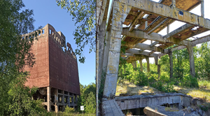
Figure 8. The ruins of the plant: A) the multi-storey coal mill; B) the concrete frame of the coal power plant; C) preserved relics of the plant registered by ALS (openness-positive) (figure by G. Kiarszys).
In 1965, a new chemical factory for mineral fertilisers was established adjacent to the old plant. Consequently, the remains of the Second World War plant became a sort of troublesome remnant, which could not yet be referred to as heritage. Like many abandoned military installations, however, the plant acquired an aura of mystery, not least because Polish military supervision of the site did not end until the 1990s.
Unwanted, abandoned, repurposed: the fate of violent infrastructure and its legacy
What remains today of the Hydrierwerke are monumental ruins, prominently visible in the cultural landscape of modern-day Police. These material remains have become a form of “violent infrastructure” (Bennett Reference Bennett, Bharne and Sandmeier2019: 218), a memento of a troubled and often unwanted past. Instead of being ignored by the post-war Polish population, the plant continues to provoke interest, playing an active role at individual, collective and administrative (political) levels. This influence can be categorised into three spheres: context-independent use of the ruins, bottom-up commemoration, and heritage tourism.
After the fall of the Iron Curtain in 1989, the area gradually became accessible to the public but the plant fell victim to misunderstanding and misuse. This was due to several factors: the absence of comprehensive documentation about the site hindered understanding and management; a lack of education and awareness about the historical significance of the site among the public contributed to its misuse; and the site's association with the Nazi regime and its atrocities created a sense of ‘otherness’, distancing people from understanding the historical significance of the site. The lack of publicly available knowledge about the Hydrierwerke not only led to unsupervised attempts to explore and scavenge the site but also resulted in a shift in the meanings attributed to the site.
In the collective memory of the Polish population of Police, the ruins of the old plant acquired a new role after military supervision ended. From a forbidden space, it became a kind of ‘other world’, where everyday laws were suspended and where virtually anything could, or even should, happen. This period was marked by a strong presence of groups such as punks, people using drugs illegally, and even (so-called) ‘Satanists’. True or imagined, these sub-cultures blended well into the mental image of the ruins, helping to reinforce their public perception of the ‘world upside-down’. The visible signs of these groups’ presence are graffiti left on the walls of the ruined plant (Figure 9A–D). Perhaps surprisingly, before the ruins of the plant were recognised as a Second World War heritage site and a memorial to forced labour under the Nazi regime, the area was already protected within the Natura 2000 framework due to its ecological habitat diversity (Figure 9E).

Figure 9. The present-day appearance of the Hydrierwerke Pölitz AG: A–D) selected examples of the graffiti within the plant's ruins; E) the concrete ceiling of the air-raid shelter scratched by bats (photographs by M. Dzikowski).
The initial step towards the bottom-up commemoration and conservation of the site was made in 2006 with the foundation of the association SKARB (’treasure’ in English), formed by local history enthusiasts. Thanks to their engagement, maintenance has been undertaken at the plant with information boards installed and paths established to allow the safe and unobstructed movement of visitors. The association provides guided tours around the plant, organises events dedicated to various groups and publishes articles on the history of the site. The outcome of these activities is the rise of heritage tourism, including visits from former labourers, some of whom have shared insights into previously unknown details of the plant's wartime conditions, layout and work.
While some of the locations directly related to the Hydrierwerke were abandoned and left unused, others underwent reconstruction to serve new purposes. In a perplexing turn of events, not long after the end of the war, the buildings of the former conjoined concentration sub-camps of Stutthof and Ravensbrück were repurposed into a pig farm. Even today, this site, once marked by the suffering of thousands of prisoners, functions as an industrial district with various workshops and warehouses (Figure 10A). Many of these buildings incorporate the original walls of the prisoners' barracks, preserving the spatial layout of the camp with its internal roads. Only the stones bearing commemorative plaques beside the main gates inform visitors about the dark history of this compound.

Figure 10. A) Barracks in the former joined concentration sub-camps of Stutthof and Ravensbrück repurposed today as workshops and warehouses; B) one of the air-raid shelters adapted for the SKARB Museum exhibition space; C) auxiliary buildings of the former Hydrierwerke Pölitz AG, now housing a workshop manufacturing life-sized plastic dinosaurs (photographs by Grzegorz Kiarszys).
As of now, the SKARB association rents two air-raid shelters as exhibition rooms (Figure 10B), showcasing military artefacts and information about the site. Part of the exhibition is dedicated to commemorating the fate of enslaved workers. This serves as yet another example of the appropriation of ‘violent infrastructure’, albeit in a more empathetic and historically aware manner than the case of the former concentration camps. Just beside the museum, there is a group of auxiliary buildings that survived the bombing campaign and which were restored after the war. Currently, some of these buildings serve as a workshop manufacturing life-sized plastic dinosaurs (Figure 10C). This amalgam of different functions and meanings creates an almost surreal atmosphere at the site, placed in the shadow of monumental concrete structures that resemble the ruins of some alien civilisation driven by irrational and cruel rules. Today, one may point out a growing need to strengthen the shift from an enclave of otherness/amusement towards the monument of war crime and victimhood. Although not excluding the aura of mystery, we may observe a gradual shift towards a more mature and empathy-orientated discourse, based on biographies and archaeological analyses, rather than imagination.
Conclusions
The landscape of the Hydrierwerke provides valuable insights into the historical context and significance of the Nazi military industrial complex. The combined analysis of historical aerial photography, remotely sensed imagery, material remains and historical documents contribute to the enhancement of cultural value and social awareness regarding the site's past. Moreover, archaeological investigations provide tangible evidence of the site's historical significance, validating its importance as a cultural heritage asset. The documentation of archaeological finds, coupled with public engagement initiatives such as exhibitions, guided tours and educational programmes, fosters a deeper appreciation for the site's role in shaping the broader narrative of Second World War history. This archaeological perspective serves as a catalyst for broader societal reflection and commemoration. By illuminating the past and raising awareness of the site's cultural significance, this work contributes to the preservation of collective memory and the promotion of historical understanding. In this way, the ruins of the Hydrierwerke are not simply the remnants of a bygone era but poignant reminders of the difficult human experiences and legacies of the Second World War.
The case of the Hydrierwerke Pölitz AG demonstrates that the importance of Second World War material heritage is still being negotiated within contemporary social discourses. Eight decades after the conflict ended, questions about the true scope and potential of the conflict's heritage remain open. In this sense, archaeological studies of Second World War sites and landscapes can only help in advancing a better understanding of this difficult legacy and stimulating fruitful, albeit uneasy, discussion.
Acknowledgements
We want to thank Rog Palmer for his valuable comments, Paul Barford for his suggestions and proofreading, Mikołaj Kostyrko for his aid with aerial photographs and the members of the SKARB association for their help and advice.
Funding statement
This research received no specific grant from any funding agency or from commercial and not-for-profit sectors.


