


Background
Redes Andinas is an ongoing project designed to research the complexity and long-term history of Andean road networks. It looks beyond the Inca roads paradigm—a chronologically exclusive approach centred on the expected monumental architecture of Inca roads—to consider the diversity of infrastructures and traces of movement that have accumulated in Andean landscapes, the study of which can contribute to our understanding of long-term territorial dynamics (Hyslop Reference Hyslop and Trombold1991).
Ancient paths and road networks are complex archaeological entities that are not often researched systematically (Robert & Verdier Reference Robert and Verdier2014). To help address this issue, the project aimed to devise methods for combining survey, chronological assessment, and topological analysis. The approach aims to explain the diversity and chronological dynamics of the networks, taking advantage of the potential of Andean desert and highland regions that generally preserve fine-grained archaeological pictures of ancient territories (with integrated records of ancient landscapes, settlements, pathways and off-site surface artefacts). In this context, a high-resolution and multiscale approach to road-networks dynamics can be achieved by combining aerial and field survey data. This article presents an overview of this approach, and introduces the project's major advances in three complementary lines of research, while its most significant insights in terms of methodological development are highlighted in the conclusion.
Case study
Since 2018, Redes Andinas has conducted fieldwork in a transect that extends between the Pacific Ocean and the Altiplano along the 18°S parallel (Saintenoy et al. Reference Saintenoy, González and Uribe2019). This region of the South-central Andes, at the crossroads of Chile, Bolivia and Peru, has experienced three historical conjunctures that significantly reshaped territories over the past millennium: Inca imperialism (fifteenth–sixteenth centuries); Iberian colonialism (sixteenth–seventeenth centuries); and the formation of the Criollo Republics (since the beginning of the nineteenth century). During all three, road networks and movement systems played crucial roles, involving macroregional territorial dynamics, specifically related to the interactions of the late pre-Hispanic and early Colonial vertical archipelagos, to Potosi's Silver Colonial Route and to the establishment of the modern Republican borders. For this reason, this region offers a significant case study of the historical processes of Andean road networks.
Methodology and results
1) The cumulative-palimpsest regional approach
As is the case with many desert and mountain regions, the 18°S parallel's Andean transect conserves abundant traces of (abandoned) pathways that do not appear on topographical maps. Seen from above, these lines draw a formation of overlapping and intersecting remnants of distinct historical road networks. This archaeological assemblage corresponds to the concept of a “cumulative palimpsest” (Bailey Reference Bailey2007). Its study has the potential to identify the original pattern of ancient historical networks, as well as their transformations through time (Llobera Reference Llobera2020). The interpretation of satellite imagery, combined with the digitisation of historical maps, allowed us to record 18 600km of these entangled lines in three vertically and continuously distributed regions (Figure 1). Then, the topological modelling of this archaeological record of a palimpsest of road networks, integrated with settlement pattern data, enabled us to assess the imperial control of mobility in the region during the Inca period (Mendez-Quiros & Saintenoy Reference Mendez-Quiros and Saintenoy2021), as well as the most-likely chronology of road segments’ use and networks’ morphological transformations during the past millennium (Nuninger et al. Reference Nuninger, Saintenoy, Verhagen, Libourel, Mendez-Quiros and Rodier2020).

Figure 1. Map of the 18°South parallel's Andean occidental transect (figure by author).
2) Pedestrian survey of pathways
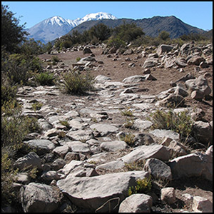
Taking advantage of the potential of the South-central Andes desert for off-site field survey, we examined a sample of 500km pathways, recording road architecture as well as surface artefacts of chronological and functional significance (Figure 2). Overall, built roads are the minority and are generally limited to terraced segments on the steepest terrain. Stone-paved segments are mostly limited to the entrance of certain highland colonial villages, and we identified none that were directly associated with an Inca site (Figure 3). The most common roadside structures are cairns, apacheta, small refuges (pascana) and corrals. Almost all surveyed segments exhibit a mixed late pre-Hispanic and historical archaeological record (although in variable proportions), which shows the resilience of roadside architecture used during the past millennium.

Figure 2. Abandoned road segment surveyed with the advice of local population who used them until the introduction of motor vehicles from around 1950 (photograph by author).

Figure 3. Stone-paved road segments—such as this one from the highlands in the proximity of Zapahuira (Arica-Parinacota, Chile)—are very scarce in the valleys and highlands and absent in the Altiplano (photograph by author).
3) Tambos archaeology
Although commonly associated with the Inca Empire, the tambo (a roadway station settlement) is an Andean institution that has transcended the Spanish colonial conquest and even played a role in the formation of Criollo Republics. Thus, tambos constitute a key element for research on the history of Andean road systems, and for this reason, we carried out a comparative study of five tambos. Excavations revealed only two tambos of pre-Hispanic origin, one of which displayed Inca-style architecture. Two other sites with seemingly Inca-style architecture appear to have been established during the Colonial and Republican periods (Figures 4 & 5). The fifth site showed the coexistence of a European and indigenous tambo during the nineteenth and twentieth centuries. The sequence illustrates the complex history of this Andean institution and indicates the need for detailed archaeological research at tambo sites, which could challenge those assumptions made about their Inca or Colonial origins that are based solely on architectural appearance or ethnohistorical stereotypes.

Figure 4. Archaeological excavation of houses and foundation terraces suggests that Tambo Chungara, which was registered as a Chilean national monument in 1983 for its apparently Inca architecture, is more likely a Republican building related to the establishment of the international border (photograph by author).

Figure 5. Archaeological excavations revealed that, despite its kallanka appearance, Tamboqollo's rectangular structure (behind the corral in the foreground) was built and used during the Colonial period (photograph by author).
Conclusion
From the historical standpoint, the multiscale approach of the Redes Andinas project has revealed two fundamental pieces of information about the process of road networks in the 18°S parallel's Andean transect over the past millennium. Firstly, most of the abundant roads and paths dispersed throughout the distinct ecological floors have been resilient from pre-Hispanic times until the widespread use of motorised vehicles during the second half of the twentieth century. Secondly, Inca and Spanish powers showed no significant attempts to engineer an imperial infrastructure for Qhapaq ñan nor Potosi's Silver Route. In this region, road/pathway architecture associated with imperial/colonial routes is very scarce and mostly related to occasional terrain arrangement rather than top-down systematic and monumental planning.
From a methodological standpoint, our experience highlights five crucial criteria for the archaeology of Andean and global road networks:
• the empirical archaeological data from our project supports the theoretical assumption that the cumulative palimpsest is an adequate framework for understanding the chronology of road networks;
• the chronological assessment of road networks is best considered through feedback between the distinct lines of evidence;
• the multiscale approach is functional not only because the high-resolution local data allow us to record empirical details of the regional perspective, but also because the latter facilitates the production of contextual and complementary data about the former;
• regional integration of road networks and settlement patterns data enables a comprehensive understanding of ancient movement systems and practices, in relation to territorial structures and networks dynamics; and
• regional and macroregional collaborative research is fundamental for consolidating datasets to realise the full potential of road networks archaeology as a synthetic approach to ancient territoriality.
Funding statement
This research has received funding from the French Ministry of Europe and foreign affairs, from the European Union's Horizon 2020 research and innovation programme under grant agreement MSCA 800617, from RYC2020-030189-I by MCIN/AEI/10.13039/501100011033 and from the Axencia Galega de Innovación (GAIN)—Ref. IN607D 2023/11. More information on projects and the collaborations framework is available in the Redes Andinas research blog (https://redesandinas.hypotheses.org/).


 Open access