Published online by Cambridge University Press: 01 May 2009
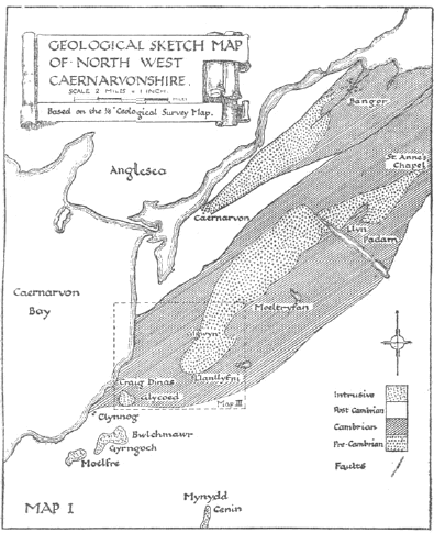
The existence of two ridges of Pre-Cambrian rocks in South-West Carnarvonshire is well known. The more northerly of these ridges extends from near Bangor to Carnarvon, a distance of just over 8 miles. It runs in a south-westerly direction, close to and parallel with the Menai Straits, and terminates at the hill called Twthill—a prominent feature in the town of Carnarvon. The more southerly ridge—commonly known as the St. Annes–Llanllyfni ridge—stretches from St. Annes in the Nant-Ffrancon Valley to the village of Llanllyfni in the Nantlle Valley. This ridge is 12 miles long and has a south-westerly trend; it is therefore roughly parallel to the Carnarvon-Bangor ridge, from which it is distant about 2 miles. It is with the area at the south-west end of the St. Annes–Llanllyfni ridge that the following remarks are concerned. The object of my

investigation has been to establish the succession of rocks in this area, and to correlate it, if possible, with the main portion of the ridge lying to the north-east. The results are set out in detail in the following pages. Text-map I shows the position of these two Pre-Cambrian ridges and also the extent of the area to be considered in detail.
1 Ramsay, A. C., Geology of North Wales (Mem. Geol. Surv.), vol. iii, p. 2, 1866.Google Scholar
2 Op. cit., p. 142.
3 Op. cit., p. 140.
4 Q.J.G.S., vol. xxxiv, p. 132, 1878.Google Scholar
5 Q.J.G.S., vol. xxxiv, p. 142, 1878.Google Scholar
6 Q.J.G.S., vol. xxxv, p. 310, 1879.Google Scholar
7 Geol. Mag., Vol. IX, p. 552, 1882.Google Scholar
8 Q.J.G.S., vol. xliv, p. 282, 1888.Google Scholar
9 Q.J.G.S., vol. xxxiv, p. 148, 1878.Google Scholar
10 Q.J.G.S., vol. xxxiv, p. 142, 1878.Google Scholar
11 Q.J.G.S., vol. xxxv, p. 311, 1879.Google Scholar
12 Geol. Mag., Vol. X, p. 70, 1883.Google Scholar
1 Ancient Volcanoes of Great Britain, vol. i, pp. 160–163, 1897.Google Scholar
2 Q.J.G.S., vol. xliv, p. 288, 1888.Google Scholar
3 Geol. Assoc. Report of Blake's Caernarvonshire Excursion.
1 Mem. Geol. Surv., 1886, p. 140.Google Scholar
2 Op. cit., p. 143.
3 Q.J.G.S., vol. xxxv, p. 297, 1879.Google Scholar
4 Harker, 's Bala Volcanic Series of Carnarvonshire, 1888, p. 44.Google Scholar
5 Q.J.G.S., vol. xxxv, p. 296, 1879.Google Scholar
6 Op. cit., p. 298.
7 Geol. Mag., Vol. IX, p. 552, 1882.Google Scholar
8 Bala Volcanic Series of Carnarvonshire, 1888, pp. 44–45.Google Scholar
1 The area here dealt with is shown on Map II in dotted lines.
1 Flett, J. S., Mem. Geol. Surv. (Newton Abbot), 1913, p. 60.Google Scholar
1 Mem. Geol. Surv., 1866, p. 143.Google Scholar
1 See extract on p. 21.