




Introduction
In Great Britain during the 1960s, amid what urbanist Peter Hall has called ‘the golden age of regional policy’,Footnote 1 a widespread demand emerged for social and cultural values of land to be considered in planning deliberations alongside the more readily quantifiable ones typically included in cost-benefit analysis. The widespread interest in non-monetary landscape evaluation emerged with the need to appraise landscape quality together with other attributes of the human environment, for example those gained from economic, natural resource and other surveys, in the formulation of regional plans and in assessments of specific development proposals. Often the general aim was to ensure that the visual amenity value of land was considered in the choice of areas for urban expansion and countryside recreation, industrial development, mineral workings, afforestation, and in routing of communication and power lines.Footnote 2 This was pertinent especially in the development of ‘structure plans’ – a strategic and future-looking development plan that was required by the Town and Country Planning Act 1968. The staff of local planning authorities, tasked with formulating such plans, deemed that information about landscape quality was essential to navigate between the interests of different stakeholders.Footnote 3
This article discusses how planners and landscape architects, grappling with the issue of competing land uses, invented or adopted statistical assessment methods as means of gaining a supposedly unbiased understanding of how different landscape areas are valued by communities. Consequently, an emphasis emerged in landscape assessment to define a standardised method of attaching a numerical value for the personal responses to aesthetic or scenic quality. One aim of these efforts during the period 1965–85 – here collectively referred to as the landscape evaluation movement – was to agree upon a standardised method of quality evaluation that would give planners and decision-makers reliable and consistent information about observers’ responses to landscape. Another goal, shared between the pioneering landscape practitioners involved, was to reify the professional judgements and expertise of landscape architects, which they hoped would help them become a more significant influence within planning control at a local, regional and national level.
Tracing developments in British town and county planning during the 1960s and 1970s, a period hallmarked by local government reorganisation, this article describes the sudden upsurge of landscape evaluation method-development that emerged among landscape architects and planners, and the disputes that made such efforts come to an end in the late 1970s. In this burst of activity, we can observe competing definitions of visual amenity and landscape quality take form. Struggling to make themselves heard in a planning sector largely dominated by more powerful stakeholders and quantitative approaches (for example, cost-benefit analysis), in the landscape evaluation movement, we can also witness how practitioners adopted a rigorous statistical approach to communicate such values more effectively. This strategy is understood here as a deliberate attempt by these practitioners to set themselves apart, supplanting the conventional approaches to landscape quality assessment based on the intuition, personal experience and trained eye of the planner. According to cultural geographer David Matless, the ‘educated eye of the citizen’, perceiving landscape in particular ways, was upheld as ‘a potentially vital organ of reconstruction’Footnote 4 during the interwar and postwar period. The subsequent landscape evaluation movement, discussed here, can be understood as attempts by landscape practitioners to occupy a more active and central role in the process of landscape transformation that continued during the 1960s and 1970s.
Despite the support offered through policies and planning legislation, still in the early 1960s, landscape architecture was a marginalised profession in comparison with town planning and architecture.Footnote 5 In 1960, the professional body of the ILA had a total of 434 members, of which only 120 were qualified to carry out independent work.Footnote 6 In contrast, the Royal Institute of British Architects (RIBA) reported approximately 43,500 members during the same period.Footnote 7 The call for landscape architects to take a leading role in countryside planning was thus received by many landscape practitioners as a major challenge.Footnote 8 Feeling ill-equipped, many lamented the lack of established theory and practical working methods with which to address the complex problems of land use and planning. There was simply no apparent method for identifying what areas of the countryside were valuable, to whom, and for what reasons. However, as this article will show, a section of the landscape architecture profession seized this challenge as an opportunity. To them, this was a golden opportunity to express their professional expertise by helping to solve an urgent national problem. Looking for something that could play well in complex planning debates, landscape architects began developing new methods of practice that suited the wider scientism of the period.
To communicate amenity values of land in a new way, pioneering landscape practitioners developed methods as tools meant to enable an evaluation to be repeated by different observers, or carried out in different areas, and still produce comparable results. Published reports and archival records indicate that, during this period, civil servants at local planning offices and practitioners in private consultancy firms invented at least forty different methods to record, visualise, and communicate non-monetary values of landscape.Footnote 9 However, despite the abundance of methods developed, few were tested in areas other than where they were conceived. In addition, on occasions when the same tract of land was assessed using different evaluation methods, the results proved incompatible. Thus, in the mid-1970s, a widespread concern developed about the theoretical soundness of dominant empirical methodology.Footnote 10 Geographer Jay Appleton was alarmed, noting that:
in collecting value-judgements, however objectively, and converting them into the basis of scientific conclusions, we should not deceive ourselves into believing that this can be done without making many assumptions about the fundamental nature of aesthetic experience and its relationship to the enjoyment of nature.Footnote 11
Results of comparative studies were published indicating that a wholly subjective evaluation (no method, no criteria) was as reliable as methods more statistically complex and operationally laborious. Yielding to the sustained critique, the appetite seized for capturing qualitative values of land in numeric measures. As a result, the landscape evaluation movement dissolved approximately a decade after it had begun. In its wake, a new planning process emerged: landscape character assessment. It was (and remains) a process that attempts to explain the unique combination of elements and features that make landscapes distinctive, a process primarily focused on description and classification rather than evaluation and interpretation of landscape.
Fighting ‘landscape erosion’ with numbers
In the decades after the Second World War, notions of categorisation and classification became ubiquitous throughout efforts to plan and reconstruct Great Britain’s physical and cultural landscapes.Footnote 12 In town and country planning, in tune with wider currents of scientific and rational thought across society during this period, ideas of reason, order and objectivity began to replace the traditional values of intuition, experience and artistry. One example of such classification was the designation of landscape areas of special interest or value. After 1945, in different parts of Great Britain, planning Acts and policies were introduced that assigned official designations to land areas, for example National Parks, Areas of Outstanding Natural Beauty (AONBs) in England, Wales, and Northern Ireland, and National Scenic Areas (NSAs) in Scotland.Footnote 13 These official labels were meant to enable more rational, systematic and efficient landscape management and planning control, as well as some protection for scenic or amenity areas. As industrial expansion gained momentum during the 1950s, especially due to the soaring demand for electricity, it became evident that the landscape designations were not enough to protect the heritage landscape, and that vast stretches of land between designated zones needed more effective planning control.
The 1950s witnessed an outcry from the general public against what they perceived to be an ongoing destruction of the countryside – the debates surrounding the British ‘Super Grid’ being one prime example of such conflicts.Footnote 14 This widespread disquiet was often centred on the idea that many planning approaches employed during the postwar reconstruction period had been too far removed from people’s everyday experiences, leading to a perceived loss of both bucolic countryside and a sense of community.Footnote 15 Thus, one of the most important objectives of landscape evaluation for local authorities was landscape preservation, which required a detailed understanding of what areas were most valued by communities.
A key term in planning debates during the late 1960s and 1970s, ‘landscape erosion’Footnote 16 was a term coined by planner Ken D. Fines in 1968 to refer to the perceived destruction of the countryside.Footnote 17 Fines was among the first to argue that in order to know which areas to protect from ‘erosion’, planners needed a means of establishing the scenic value of different landscape areas as held by communities, and an effective way to communicate such values in a unambiguous format. A major difficulty in establishing such agreed values was to develop techniques that could be easily replicated when used for the same purposes in different topographical contexts. A further problem was that the skills required to adopt sophisticated techniques, for example, advanced statistical or mathematical ones, did not often exist within the organisations of all but the best equipped planning departments. With the calls for simple systematic assessment and ease of application, an appeal of simple calculation and numerical clarity – what Theodore Porter calls a ‘trust in numbers’ Footnote 18 – quickly came to dominate the landscape evaluation movement. But the question remained: what exactly was to be counted or captured numerically?
The answer to that question varied greatly between different planners and projects. Some advocated classificatory descriptions of landscape by which visible features in the landscape could be identified, counted and compared. Other efforts were dedicated to evaluative analysis meant to capture subjective and individual responses that were not necessarily linked to tangible landscape features. Ian C. Laurie of the University of Manchester Department of Town and Country Planning called this distinction that between character and quality, simply one between descriptive versus evaluative approaches where the former often formed the information base for the latter.
To engage this vast history of practices and ideas, I identify in this article two broad categories of landscape evaluation methods: preference techniques and measurement techniques.Footnote 19 In both categories, methods employed numerical scales to translate judgements by individual assessors to a calculable format. In the measurement techniques, statistical analysis of landscape features formed the backbone of allegedly objective evaluations. A characteristic of the preference techniques, on the other hand, is the reliance on summation of individual responses. As we will see next, such subjective appraisals were sometimes carried out by sample groups of laypersons, and sometimes by qualified surveyors and trained experts.
Preference methods
Peculiarly, methods in which members of the public were asked directly about how they value landscape received least attention in the landscape evaluation movement.Footnote 20 One reason for that was that questionnaires and interviews were generally considered highly time-consuming and costly. Most planners advocating public participation in assessment therefore aimed to construct a prediction technique of known reliability and validity that was based upon actual responses from members of the public. Advocates for this approached believed that if a reasonable number of judges assess each landscape, the ‘democratic principle’Footnote 21 of landscape evaluation would be honoured. But what constituted a reasonable sample size and who were suitable observers?
Methods where landscape users were directly asked to state their preferences were typically of two kinds. Either individuals were interviewed out in the field, or surrogates, such as photographs, were used to represent the landscape. A landscape evaluation project in East Sussex, covering 773 acres of undeveloped land, was one of the earliest attempts to devise a systematic method of recording public preferences. Its objective was to select the route for a supergrid transmission line.
The method, invented by Fines, involved two steps.Footnote 22 First a worldwide scale of values was devised by asking a select group to rank landscape views presented to them in photographs. These photographs were used as surrogates to stimulate landscape experience. For the study in East Sussex, Fines selected a sample group of forty-five people, and asked each person to independently rank and evaluate the beauty of various landscape and townscape views (for example, of the Isle of Skye, the Dolomites, Brentwood) presented in colour photographs. One of the photos was provided as ‘control view’ and given a value of 1 to serve as an index for numerically rating the other views. After the initial evaluation, results were analysed according to the amount of training and experience each person in the sample group had in a design discipline. Over the course of the study, Fines found that this factor has a significant impact, not on the ranking itself but on the respective range of values from the least attractive views to the most attractive. The range was found greater for the subgroup with considerable training or experience in design. ‘There is a good indication’, Fines reported in 1968, ‘that the appreciation of landscape and the awareness of the subtleties of landscape becomes more acute with training and experience.’Footnote 23 Full appreciation of landscape, according to Fines, was thus something that would be taught and practiced.
D. M. Brancher from the University of Bristol disagreed and questioned Fines’s assertion that trained observers make more insightful quality judgements. The method of establishing a worldwide scale of values, Brancher considered to be, simply, ‘subjectivism dressed as science’ (Figure 1).Footnote 24
County of East Sussex landscape evaulation map by Ken D. Fines, ‘Landscape evaluation: a research project in East Sussex’, Regional Studies, 2:1 (1968), 44.

In Fines’s method, the value scale that resulted from the surrogate assessment comprised a numerical series from 0 to 32.0 arranged in six descriptive categories: unsightly (0–under 1), undistinguished (1–under 2), pleasant (2–under 4), distinguished (4–under 8), superb (8–under 16) and spectacular (16–32). A value of 24 was taken to represent the highest that could be obtained on a world scale by a spectacular view that is not enhanced by transient atmospheric phenomena.Footnote 25 Once out in the field, observers judged the landscape in sight in relation to the established value scale. Evaluations from two observers were deemed sufficient in establishing an area’s visual quality. Once evaluations were complete, assigned values were averaged and used to produce maps of landscape quality. These maps were in turn used to formulate urban expansion policy, and to select routes for communication networks and sites for projects in open country. The County Council used the resulting East Sussex County Landscape Evaluation Map to select a route for an electricity transmission line from Dungeness Nuclear Power station to Exeter with towers up to 210 feet, spanning.Footnote 26 After the line was constructed, Fines and his team calculated that, because of the completed development, the mean landscape value of the administrative county had been reduced from 5.42 to 5.35. Had the original route been constructed, they asserted, the mean value would have been reduced to 5.32. According to Fines, both landscape quality and the speed of landscape erosion could be described and communicated at a very fine resolution.
After the results of the East Sussex study were published, Brancher and others ridiculed Fines’s numerical approach, arguing that it simply entailed a move from ‘from ordinality to cardinality’.Footnote 27 What evidence, Brancher queried, supported the idea that photographs suffice as proxies for direct visual experience of landscape?Footnote 28 In part, Fines agreed with the critique but argued that in spite its subjective basis, the method had proven successful in placing the East Sussex Country Council in a stronger position in the development control process.Footnote 29
In the decade after Fines’s assessment work was published, the method became widely circulated and influenced many local planning departments to make evaluations of a similar kind. Yet, it also commanded critique for being subjective through and through.Footnote 30 Recognising that evaluation is inevitably subjective, Fines argued that ‘if subjective judgement is inadmissible then the planner is culpable whenever he delineates an area of great landscape value or refuses planning permission on grounds of “visual amenity”.’Footnote 31 The larger goal, he noted, was to produce explicit evidence to support planning decisions. Methods of this type, Fines later admitted, are tools for planning officers who are forced to make subjective aesthetic judgements in regard to individual sites and proposals.Footnote 32 This statement implies that the frenzy of method-development was often geared towards increasing the authority of landscape planners, and to reify their professional judgements.
Another method developed by a team of planners at the East Suffolk Country Council in 1973 relied solely on expert judgements. It worked by establishing the consensus of evaluations carried out by the Council’s planning staff. A study area was first divided into ‘landscape identity tracts’Footnote 33 based on landforms, relief and vegetation type. Members of the planning office staff then graded each tract based on their own preferences, according to five categories. The mean score for each tract was then calculated, as was the standard deviation to indicate the extent of agreement between staff members. Despite this reliance on expert judgements, criticism grew of methods based on the opinion of one or groups of individuals who personally decided which features would be used to identify areas of high or low landscape value. As noted by Penning-Rowsell, many practitioners hoped that more systematic methods would allow planning professionals to assess landscape qualities without attracting criticism for influencing the results according to their own feelings.Footnote 34 A more unbiased approach, a growing number of planners argued, was to devise a method of measuring quality using readily visible features and characteristics in the physical landscape.
Measurement methods
A set of methods emerged in the 1970s that challenged the assumption that landscape quality was an aesthetic question intrinsically liked to subjective opinion. Planners and landscape architects with scientific propensities believed that if stable links between personal attachment and visual landscape features could be identified, these links would support a semi-automated procedure based on statistical analysis rather than personal intuition. Statistical analysis would provide, they held, what geographer Edmund Penning-Rowsell called a ‘strong factual basis’Footnote 35 for landscape evaluation work.
In a 1969 study of the Scottish Clyde estuary, Arnold Weddle – Britain’s first appointed Professor of Landscape Architecture at the University of SheffieldFootnote 36 – followed a different, more covert, approach. The aim of the Clyde project was to find new sites for industry within the estuary. To locate areas that could be developed at least social cost,Footnote 37 ones of high value had to be identified. Weddle assumed that the landscapes most valued by communities are those most frequently used by inhabitants and visitors. The method he devised thus involved assessing the public’s attitudes to landscape without participants knowing that they were being canvassed. First, a landscape component survey was conducted to record views, background scenery, and foreground vegetation of prominent spots, features that Weddle referred to as ‘inherent values of landscape’.Footnote 38 As a second step, population and visitor counts of the different study locations were recorded. To determine relative popularity (the ‘acquired value’) the list of landscape features was contrasted with the people count. This meant that an area’s final quality rating comprised an ‘aggregate landscape value’ that derived from summarising counts of components and persons. Finally, each land unit was given a one, two, or three-star rating indicating its quality. But did patterns and frequency of use really capture landscape quality?
Other assessment methods used maps to establish features understood to contribute to quality, and worked by assigning weight to each feature. This was the approach used in the Coventry-Solihull-Warwickshire (hereafter C-S-W) Sub-regional study, which ran from 1969–71. In the study, to evaluate a landscape using maps (without leaving the office), the proportion was measured of the area that each feature occupied, where after the weighted proportions were aggregated to establish relative values (Figures 2 and 3).
Computer map of landscape quality grades, produced in the Coventry City Council, Solihull County Borough Council and Warwickshire County Council, Sub-regional Planning Study. The Report on the Sub-regional Planning Study (Coventry, UK, 1971).

Computer map of landscape values, produced in the Coventry-Solihull-Warwickshire Sub-regional Planning Study (1971).
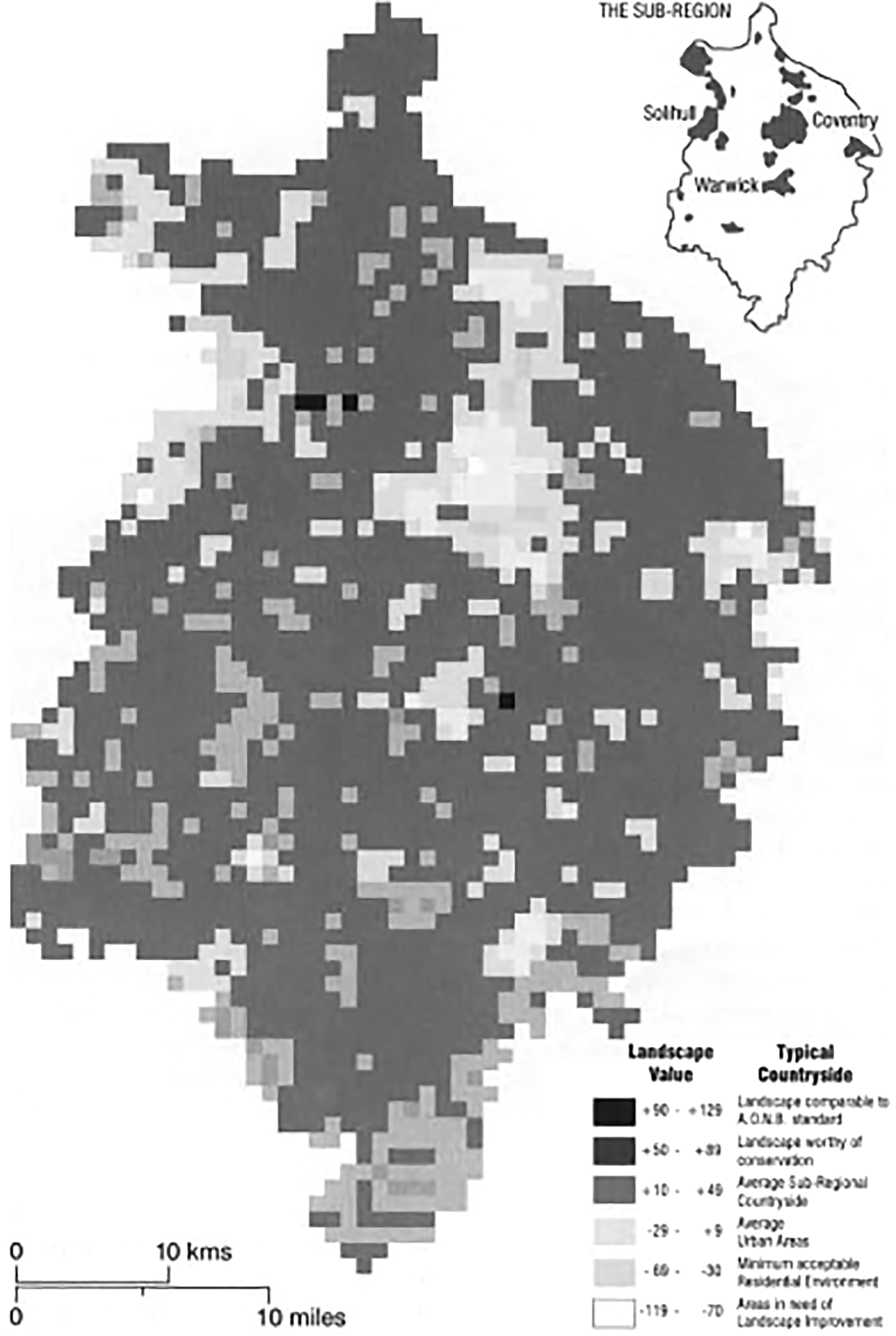
The goal of the C-S-W study was to develop techniques that would provide rapid results for structure planning purposes. It would become the, until then, most comprehensive and technically complex approach to generate information about landscape quality, and became a model of goal-oriented planning and the rational planning process as a whole.Footnote 39 With its basis in statistics and numerical analysis, this project was also one of the first attempts to use electronic computers to calculate qualitative values of landscape.Footnote 40 The study team, an independent technical body appointed by the Coventry City Council, set out to demonstrate the applicability of statistical analysis, which they held would allow fine resolution analysis of subtle landscape variations (found in Warwickshire, in particular). The approach would also, the team envisioned, facilitate prediction of future changes.
To control subjectivity, the team separated the ‘subjective’ evaluation stage from the collection and analysis of ‘objective’ landscape data. The method was technically complex and relied on defined weights as the dependent variable (axioms) in calculations. Graham Harrison and Bob Stokes were in charge of the countryside component of the extensive subregional study.Footnote 41 Working to a one-kmsq module, the team began by mapping topography, slopes and level areas, and landscape units defined by topographic ridgelines. From that survey they found that the study area of 2,500 grid squares could be reconfigured as 250 ‘landscape units’.Footnote 42 Taking cues from an assessment method developed by landscape architect Clifford Tandy (discussed below), Stokes designed a plan on a grid basis but with lines distorted according to topography so as to illustrate which points in the landscape are visible from where. A punch card was filled out in the field for each map square to later be fed into a computer data bank. In the scoring method, emphasis was placed on land form, land use and landscape features. Noticing that initial weights derived from evaluations by members of the research team, Penning-Rowsell critiqued that despite the complex computations, ‘the apparent objectivity is a façade’.Footnote 43 E. J. Allett, Operational Research Executive at British Coal, agreed stating that the quality of landscape may depend on ‘very subtle characteristics of physical components which are only appreciated by the eye and do not lend themselves to measurement’.Footnote 44 Countering these arguments, Michael Dunn from the Centre of Urban and Regional Studies at the University of Birmingham pointed to studies where the mathematically derived rankings had been found to closely match those from subjective surveys.Footnote 45 Despite the criticism and debate, the C-S-W method quickly gained popularity. The possibility of expedient calculations, clear variables, and repeatability promised to revolutionise landscape evaluation, if only the underlying principles could be agreed.
In the early 1970s, Clifford Tandy, the then President of the Institute for Landscape Architects (ILA), developed a method of landscape evaluation that directly combined quantitative and qualitative aspects of landscape in an explicit way. The method was developed for the Countryside Commission for Scotland to assist classification of Scottish landscape resources.Footnote 46 The main aim for the Countryside Commission for Scotland in commissioning the study was to find a way to grade landscape resources of Scotland’s countryside and coast so as to help better planning for their protection and use. The goal was thus to suggest a more ‘objective method of comparing landscape values so as to indicate their relative importance on the international, national, regional and local scale’,Footnote 47 and thereby make available a more rational basis for administrative designation.
Tandy’s method comprises a numerical scoring system associated with visually contained landscape tracts defined on the basis of maps, aerial photographs and through fieldwork. As in the C-S-W study, boundaries of tracts were drawn to coincide with one-kilometre grid squares so that data collected systematically from maps could be related to each tract. Each assessor (a trained planner or landscape architect) scored a landscape in view first according to how each element was perceived to contribute to the total character of the areas (0 inconspicuous; 1 conspicuous; 2 very conspicuous); and then with regards to the landscape’s total quality (-2 bad; -1 poor; 0 neutral; 1 good; 2 excellent). After these assessments a total score for each tract was calculated by combining scores through multiplication. Landscape quality thus derived from responses to eight possible impressions on the viewer of sixty-four different elements, including landforms, types of ground cover, water features, man-made features (dams, bridges, castles), infrastructure and communication networks, and prospect views.
The method drew upon on one that landscape architect Ronald Hebblethwaite had devised in 1968 for a study of the East Hampshire Area of Outstanding Natural Beauty (AONB).Footnote 48 In the Hampshire study, as in Tandy’s method, expert observers were instructed to visit individual landscape tracts (map squares) and assign a quantitative and a qualitative value. These values were then correlated but at no point explicitly combined. Landscape, according to Hebblethwaite, was made of two parts: the mineral base and the surface mantle. The mineral base was important as an area’s geomorphology can manifest in either strong contrasts or no contrast between vertical and horizontal landscape elements (for example mountain to lake), which score very high in Hebblethwaite’s evaluation. Accordingly, when that contrast was weaker, landscape quality was generally lower. The added value of dramatic natural scenery drew on the aesthetic theory of philosopher Edmund Burke, and particularly his concept of the sublime; a notion that concerns observations of stark proportions, greatness and infinity.Footnote 49 The theory assumes that most people will react with awe to dramatic scenery, and this was reflected in Hebblethewaite’s scoring scale. Certain visual features, however, caused a decrease in value. Landscape quality was understood to be significantly lowered if incongruous elements (‘detractors’)Footnote 50 were found present, for example mineral workings, poultry houses, old military installations, silos of poor design, refuse dumps, industrial buildings and power lines. To assist quality calculations in the field, each assessor was given a list of nineteen detractors with specified negative values.Footnote 51 In the late 1960s, once out in the East Sussex landscape, assessors marked one-inch Ordnance Survey with adhesive stickers. Dots in green and yellow were attached to the map to denote quality judgements of different areas.Footnote 52 The dots from different observers were then averaged ‘in the office’Footnote 53 to produce coloured landscape quality maps.
Responding to Hebblethwaite’s methods, Tandy raised two points of criticism. First, because no value was assigned to views that presented themselves from a locality (a grid square) the contribution of prospects in scenic evaluation was excluded. Second, Tandy argued that as Hebblethwaite made no direct association between the quantitative and qualitative analysis, no means were provided to understand their contingencies. Attempting to ‘evaluate the total quantity and quality of elements in a locality’Footnote 54 in his own method, Tandy expanded Hebblethwaite’s surface mantle categories to include ‘views out’.Footnote 55 In his method, published in 1971, Tandy limited the evaluation of each category to a maximum of five units to facilitate computer application: 0 none, 1 some, 2 all, for quantity; and -2, -1, 0, 1, 2, for quality.Footnote 56 This method, he noted, was ‘of course, like all other such methods, dependent upon the subjective opinion of the surveyor’,Footnote 57 and he noted that some common acceptance of terms should be established among a team of surveyors. Convinced of its effectiveness, Tandy reported that his method has been tested on several classical landscape paintings, which ‘predictably scored very highly’.Footnote 58
The majority of measurement methods, like the preference methods, relied implicitly or explicitly on judgements imposed by trained professionals. Yet, the use of professional judges was often criticised on the grounds that their views do not adequately reflect those of the general public. This dispute reflects a fundamental theoretical divergence of opinion at the time over whether landscapes have an intrinsic objective beauty or whether scenic beauty is a value that can only be subjectively attributed to a specific locality or landscape.Footnote 59 Those who argued that perception of the material and aesthetic qualities of landscape vary between different subgroups of the population, set out to develop standardised assessment method allegedly free from predefined scoring bias.
Debating a standard evaluation method
Out of the numerous landscape evaluation methods produced, which was the most reliable? In the mid-1970s the Countryside Commission for England and Wales set out to find it. The study they facilitated, later with the help of researchers at the University of Manchester, was probably the most comprehensive attempt to identify a reliable basis for landscape evaluation. However, the project ended in disappointment. In spite of the widespread optimism, no standard method, expected to perform reliably in evaluations across Great Britain, was ever settled.
At the outset, the aim and vision of the statutory Commission was clear: systematic and replicable recording of quality judgements would identify landscape areas most valued by communities and identify those in need of improvement, not just in one location but across Great Britain. Most importantly, such a technique would bring clarity to disputes in which the Commission was expected to play an authoritative role.Footnote 60 In general, the Commission’s role was to be a go-between mediator, to collect and disseminate information that relate to the national landscapes of England and Wales. In order to give worthwhile answers to a variety of questions concerning land use and planning, the agency required a continuous feed of up-to-date information for the entirety of England and Wales. Much of the Commission’s early work, therefore, was dedicated to establishing reliable information; a process that often revealed the difficulty in obtaining consistent observations as the basis of datasets. Variance between human surveyors in recording and interpretation, it turned out, was not easily controlled and was therefore increasingly regarded an obstacle to compare results from different areas, and in repeating observations of the same area at different times.
In the late 1960s, simultaneously with Fines’s study in East Sussex, the Commission carried out a project to study landscape changes underway across England. In The Changing Countryside Project, trained observers were commissioned to carry out surveys on sample kilometre squares throughout England and Wales. A-level students (secondary school students) and staff served as field surveyors. As had been the case in the first Land Utilisation Survey of Britain, carried out between 1930–4, the aim besides data collection was to encourage interest among school children in the relations between land and people.Footnote 61
Recording of easily recognisable features in the landscape, such as hedgerows and field boundaries, trees and tree-groupings, it turned out, was not as straightforward as the Commission had first envisioned. The complexity increased when more complex assemblies were concerned, for example vegetation types and ground surface patterns, which required more individual judgement and interpretation. The study’s educational value was pronounced, but to the Commission, the outcomes (after three years of study) indicated that neither the supervisors nor the observers could make sufficiently consistent and reliable observations. After three different systems of landscape classification had been trialled, the project was abandoned as it ‘could not provide sufficiently accurate information to satisfy … research requirements’.Footnote 62 It was virtually impossible, the Commission decided, to put together a dataset that would serve any useful purpose if it were based on observations of a number of independent people, no matter how well they had been prepared. A standardised method for evaluating landscape was required and the Commission set out to find it.
The Manchester study, 1970–4
In 1969, the Countryside Commission circulated a proposal for a three-year university study of techniques and methods of landscape analysis and appraisal currently in use.Footnote 63 Three universities, where the ILA had communicated a wish to concentrate landscape research, were approached: Manchester University, Dept. of Town and Country Planning; The University of Newcastle Upon Tyne Dept. of Town and Country Planning; and Sheffield University, Dept. of Landscape Architecture. The Manchester Centre for Urban and Regional Research was chosen and landscape architect Ian Laurie was elected to lead a team that included, among other researchers, design methods pioneer John Christopher Jones.Footnote 64 The first year, 1970–1, a review was conducted of thirty-one known landscape evaluation methods at a regional, county and local level. The theoretical basis for each method was examined, as was any standards employed, such as map scales or reference photographs. Comparisons were made, where possible, between value metrics used in different methods. As a second step of the Manchester study, a selection of methods was carried out in the field by the Cheshire County Council. These field trials aimed to test each method’s ‘repeatability or objectivity’, and to identify the personnel and costs required for its execution. In the study’s third year, the university researchers reported back to the Commission on the work undertaken and suggested the ‘most appropriate’Footnote 65 method of landscape evaluation for planning authorities.
Three years after the study had begun, two methods were proposed, which comprised combinations of features from the methods surveyed. The first method relied on subjective evaluation by observers in the field, whereas the second employed digital computers to extrapolate from found values to other areas via regression analysis. The first method began with field assessments of all the units of landscape that were chosen for evaluation. The aim of the assessment was to establish a standardisation of subjective scores. A common scoring scale was thus defined (drawing on the methods of Fines, Hebblethwaite and Tandy) to enable direct comparison of assessments by different observers. The second method built upon the first, and involved estimation of weights for a set of landscape components by regression analysis. This drew upon the Coventry-Solihull-Warwickshire subregional study’s approach. In the Manchester study, the inputs for the automated analysis were the results from the first field-based method, and quantitative measures of landscape components found in the same area (OS map square). To predict values for general visual quality in areas beyond the surveyed grid squares, the input weights were combined with measurements of components in the remaining (not surveyed) map squares. The team asserted that the recommended methods were ‘logically sound, and operationally reliable’.Footnote 66 One advantage, they argued, was that the methods allow observers to exercise their own quality judgement without influence by the survey designer, and that their judgements then form the basis for automatically calculating values across landscape. In summary, the proposal combined subjective and statistical techniques, and as such relied on the implicit assumption that the degree of a person’s appreciation for defined landscape features remains stable across different compositions thereof. The arguments put forth at large resonated with North American city planner Kevin Lynch’s neo-empirical theories in which individual landscape features provide the perceptual building blocks from which an individual’s landscape image is formed, crucial to evaluation of scenic quality.Footnote 67
Once finalised, the main finding of the Manchester study was a quantitative evaluation method that could be executed rapidly and with great clarity, but only if qualitative weights were known. This recommendation was not what the Countryside Commission had hoped for because the proposals put forth offered no new insights (theoretical or otherwise) to why some landscapes are valued more highly than others.Footnote 68 It was this realisation that marked the beginning of the landscape evaluation movement’s dissolution. In the years that followed a stream of critique emerged that challenged the assumed benefits of measuring distributions of subjective opinion with systematic methods. Empirical methodology was abundant at that point, but no theory had emerged to support the eclectic undertakings. In their recommendations, the Manchester research team asserted that because of ‘the part played by the observer’s response through eyes and mind, landscape visual quality evaluations inevitable reflect the qualities of the assessor as well as his method of assessment.’Footnote 69 This is so, they argued, because ‘the validity of the scoring scale used cannot be “proven”’,Footnote 70 as it was inevitably based on the subjective opinion of participating members. Thus, the recommendations put forth recognised the inevitability, and indeed desirability, of a subjective element in landscape evaluation. Any general procedure for assessing visual landscape quality, they suggested, should therefore involve collating opinions of quality from sample groups of assessors who make well considered but rapid aesthetic judgements.Footnote 71 A further recommendation was that to secure responsible assessment acceptable to the public at large, ‘skilled and experienced assessors drawn from the environmental and design professions should carry out the work.’Footnote 72
Results of different evaluation were also found to depend on the way landscape was defined for assessment purposes. The Manchester team regarded the cartographic grid square the best uniform basis for assessments. However, subdivision into uniform units, the team cautioned, limits the opportunity to evaluate continuous phenomena of landscape as it produces only an evaluation of landscape views within ‘the arbitrary boundary of the grid square’.Footnote 73 The most critical aspect of their recommendations, however, concerned the yardstick for evaluation. A standard evaluation method required that scores of individual assessors can be relatable to some common scale. Although numbers were regarded a valuable means of recording the general relative quality of landscape, ‘a single numerical index conveys no information as to the individual aesthetic qualities which contribute to the overall assessment of a particular survey unit.’Footnote 74 It was concluded that a numerical index could communicate relative values, but was incapable of disclosing anything about the visual content that had led to such conclusion.
Critique and dissolution
Although no standard method had been settled, the Manchester study still made significant contributions to disciplinary debates, particularly the final report presented in detail the problems of landscape evaluation and analysed the ins-and-outs of employing a statistical approach. This contribution was acknowledged by Edmund Penning-Rowsell and Glen Searle from the Middlesex Polytechnic Department of the Environment, who in 1977 – after having tested the two recommended methods in the Dacorum District of HertfordshireFootnote 75 – published a critique of the Manchester study’s recommendations.Footnote 76 Four expert surveyors had participated in the Decorum experiment. When averaging their quality judgements into a common scale (method 1), Penning-Rowsell and Searle found that the assigned values significantly differed (Figure 4). Thus, it seemed futile to average the values as the result would no longer represent either expert’s opinions.Footnote 77 The authors quoted one of the participants who was allegedly unhappy with the general approach:
I am not happy with the idea of using our scores, correlated with tree cover, water and topography, etc., to predict scores for other areas. Many other factors affect landscape quality such as personal assessments of the value lost by bad buildings, etc., and these must be very difficult to pick up from maps.Footnote 78
Landscape evaluation maps from the comparative study in the Wye Valley Area of Outstanding Natural Beauty by Edmund Penning-Rowsell and Dennis. I. Hardy, ‘Landscape evaluation and planning policy: a comparative survey in the Wye Valley Area of Outstanding Natural Beauty’, Regional Studies, 7:2 (1973), 156.

In Dacorum, the quality map produced with the two Manchester methods was compared with maps produced by the method developed by Tandy. Peculiarly, it was found that none of the grid squares given the highest scores in the Manchester map achieved the highest rating in Tandy’s map, and vice versa. Penning-Rowsell and Searle believed that the reason for this discrepancy was that in the Manchester method only three variables were considered: the presence of woodland, industrial land use, and a limited landform index. Evidently, Tandy’s method was able to consider much more complex interactions of landscape features. A second point of critique concerned detractors in the landscape. Again, Tandy’s method was found more realistic as it allowed views of distant features in the landscape, such as ones of electricity towers or motorways, to contribute to evaluation in all grid squares from where such were visible. Contributions of such intervisibility conditions were not considered in the Manchester study. In conclusion, no evidence was found to support the sole reliance on the subjective judgements of a small group of professional planners. Many of these professionals, Penning-Rowsell and Searle noted, ‘receive little aesthetic training, and there is no reason to believe that the public should have less confidence in their own judgement than they have in those of so-called experts’.Footnote 79
A. L. Traill, a consultant statistician on the Manchester study team, disagreed.Footnote 80 He acknowledged that the selection of an observer team ‘will always be problematic’, but argued that for that reason the ‘real question must focus upon the necessity for a statement of the public’s preferences’.Footnote 81 His remark implies that perhaps agreement with public consensus was not necessarily the most important goal. In response to the critique of the limited variables employed, Traill noted that much effort was spent in the Manchester study in identifying the variables that have the most significant impact, and thus rejecting others less critical. Furthermore, in response to the possibility of genuine disagreement between different (expert) observers, Traill drew the conclusion that:
evaluation is feasible only where there is a consensus among observers. Where no such consensus exists the solution to evaluation problems becomes political and no technique could or should provide a unique answer.Footnote 82
It appears that the landscape evaluation movement had thus come full circle: only where general consensus prevailed could systematic landscape evaluations be successfully undertaken – a tautological statement that seems to abolish the need for systematic evaluation all together. Geographer Jay Appleton voiced similar concerns and pointed to ‘the theoretical vacuum’Footnote 83 he thought characterised the landscape evaluation movement. Throughout the frenzy that constituted the landscape evaluation movement, little (if any) theory had been produced to support developments. Without a theoretical foundation how could one be sure that the methods performed as intended? Appleton remarked, ‘[j]ust as the Brisbane wicket after rain used to be said to reduce all batsmen to an equal level of incompetence, so this absence of aesthetic theory brings the professional down to the same plane as the man in the street.’Footnote 84 What could be done? Appleton’s response was simple: press on with empirical techniques as these were, he noted in 1975, ‘practically all we have’.Footnote 85 In lieu of theoretical foundations, it was generally agreed that the empirical studies must be continually refined, and permitted some degree of subjectivity, until something more robust and theoretically sounds could be put in its place.
Conclusions
The final nail in the coffin for landscape evaluation, was placed in the mid-1980s with the public inquiry into the designation of the North Pennies AONB in England.Footnote 86 Suggested by the Countryside Commission in 1979, because opinions on the matter were divided, this was the first occasion on which a public inquiry was held into a proposal for designation of an AONB. Although the term had been used already in the 1949 National Parks and Access to the Countryside Act, ‘natural beauty’ was now examined for the first time through a legal lens.Footnote 87 It was concluded that, in the context of designation, landscape quality and natural beauty should be considered interchangeable concepts. The appointed Planning Inspector, Sir Stephen Berthon, further asserted that in the absence of any generally accepted theoretical basis of landscape evaluation, any resolution of this ‘controversial question is a matter of aesthetic taste … or common sense’.Footnote 88 There seemed, however, to be some agreement on the general factors that could be employed when assessing what areas of countryside merit designation. Speaking at the public inquiry, the Director of the Countryside Commission, Adrian Phillip, listed some factors used by their officers in assessing landscapes, such as relative relief, landscape shape, dramatic contrast and remoteness. Reflecting on the relationship between quality and character, Berthon noted that such descriptions of landscape, of factors that make one landscape distinct from another, seemed to provide an understanding of ‘the nature, distribution and extent of differing types of landscape’,Footnote 89 facilitating a descriptive rather than evaluative analysis. While landscape evaluation typically concerned ranking visual landscape according to relative values, landscape character assessment claimed to separate the recording of visual landscape patterns from the evaluation thereof. As a result of the North Pennine AONB public inquiry, methods of landscape character assessment came to dominate landscape planning. The Countryside Commission published the first official guidelines for the landscape character assessment (LCA) process in 1988 – the same year that Environmental Impact Assessment (EIA) procedures were officially adopted in the UK – followed by a similar document for Scotland in 1992.Footnote 90 While systematic evaluative approaches were largely abandoned, the efforts of the landscape evaluation movement had not been in vain. Methods for assessing patterns of character, based on visible landscape features, had often been the first step when evaluating landscape. It was these methods that subsequently evolved into landscape character assessment – the process of identifying and describing variation in character of landscape, as opposed to intuitively interpreting or evaluating it.
This article has shown that since the call for a national landscape classification system was raised in 1963, at the first Countryside in 1970 conference, members of the landscape planning community increasingly embraced statistical methods, which practitioners hoped would render existing intuitive approaches to assigning different kinds of values to landscapes, less biased and repeatable, and therefore more influential in land use planning and policymaking. To many of the landscape architects and planners involved, assessment methods rooted in statistics and mathematics represented a possible solution to the problem of irreversible erosion of Britain’s countryside and natural heritage, but there was more at stake. To them, the widespread call for improved access to detailed and up-to-date landscape information also presented an opportunity for reifying and demonstrating their professional expertise, which they hoped would, in turn, increase their influence over decision-making and land use planning. In this context, we can see that rigorous methods of landscape evaluation were tools for planners and landscape architects struggling to communicate values, of some kind, of existing or proposed landscapes, to each other, communities and decision-makers.
But in retrospect we can see that the lack of agreement with respect to the reliability, validity and generalisability of both assessment methods and produced findings, may explain the practitioners’ limited success in this pursuit. The result, at the end of the 1970s, was a number of highly complex and complicated methods, often involving advanced statistical analysis and computing, which for this very reason were seldom implemented at local planning authorities, most of which simply did not have the required equipment and analysts and statisticians among its employees. The dissolution of the landscape evaluation movement, mostly because of the lack of sound theory to support the developed methodology, brought general a turn in landscape assessment from abstraction and mathematics to empiricism and a concern with practical matters.
The resulting process of landscape character assessment, is today often conducted by local councils and planning departments, and also by community groups, developers, landowners and consultants. While landscape architects are typically responsible for the main body of the work, a range of specialists are typically involved, from fields including ecology, geomorphology, geology and soils, agriculture and forestry, land management, archaeology, historic landscapes, cultural heritage, urban design and planning. The process sustains, in other words, the need for landscape architects’ specialist knowledge, positioning them as a key member of a multidisciplinary team. The trained eye of the landscape architect is now one of many perspectives on landscape brought together in this form of assessment. This multidisciplinary approach to addressing landscape does in some way resonate with what the Landscape Research Group sought to achieve in the mid-1960s. It was the strong conviction of its founders, that the problems of landscape could not be solved by any one discipline alone.Footnote 91 Who is best placed to tackle the evaluation of visual amenity, however, still remains an open question.
Acknowledgements
I wish to thank the journal’s editors and the anonymous reviewers of this article for their insightful comments and helpful advice.


 Open access

