


Introduction
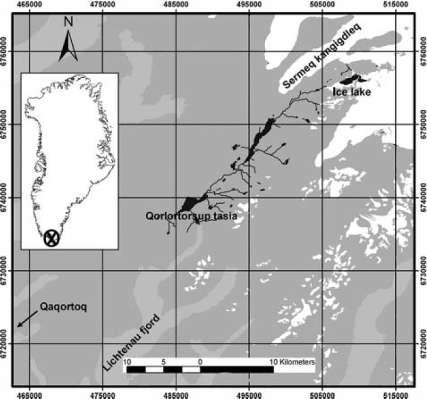
Qorlortorsuaq is the site for a hydropower plant which will supply the towns of Qaqortoq and Narsaq in south Greenland with energy. Water is supplied from a nearly glacier-free drainage basin upstream of Amitsuarssuk fjord, a northeastern tributary to Lichtenau fjord. Several lakes exist in this drainage basin. One of them, Qorlortorssup tasia, drains over a large cascade (Qorlortorsuaq, ‘the large waterfall’) and is the designated water reservoir of the power plant (Fig. 1). At the northeastern border of the drainage area an ice barrier exists (part of 1AE0001 in the glacier inventory of Greenland; Reference Weidick, Bøggild and KnudsenWeidick and others, 1995), which dammed a lake (surface area about 2.24 km2 in 1985; surface elevation about 1050 ma.s.l.). This lake (Figs 1 and 2) used to drain over a narrow rock ridge at its northern margin into the adjacent valley of Sermeq kangigdleq (glacier 1AF0802 in Reference Weidick, Bøggild and KnudsenWeidick and others, 1995). During a visit in 1992, it was recognized that the surface of the ice dam, preventing the discharge of the lake towards the Qorlortorssup tasia basin, was about 20 m higher than the lake level (personal communication from O.B. Olesen, 2003). The ice front at the lake receded about 800–1000 m between 1942 and 1985, considerably enlarging the lake area. At the beginning of July 2003, a strong increase of water flow was observed at Qorlortorsuaq, partially flooding nearby farmland. A first helicopter inspection on 2 July 2003 by Greenland Resources A/S revealed that the glacial dam was penetrated and the lake water flowed into the Qorlortorssup tasia basin. The lake level of Qorlortorssup tasia had risen by >0.5m, strongly increasing the outflow over the cascade. In order to evaluate the potential future risk and the consequences of this breach in the ice dam, a glaciological assessment study was carried out.
Overview of the location in Greenland (inset), the area of Qorlortorssup tasia and the ice-dammed lake, with the adjacent ice cap (white) and the fjord system (light grey); lakes are shown in black (map based on Reference SchjøthSchjøth and others, 2000, map projection UTM/WGS84). For a better overview, only the drainage system of Qorlortorssup tasia is shown.
Observations at the Lake
Field measurements took place during 9 and 10 July 2003. Compared to photographs from 2 July 2003, the trench in the ice barrier had deepened considerably and the outflow of water seemed to equal the inflow to the lake from the ice cap. There was no detectable change in channel depth or lake level between the two days. The spillway, where the lake drained formerly, was well above the new lake level. The water level at downstream Qorlortorssup tasia was declining at this time but still above its normal level.
Geometry of the lake and drainage channel
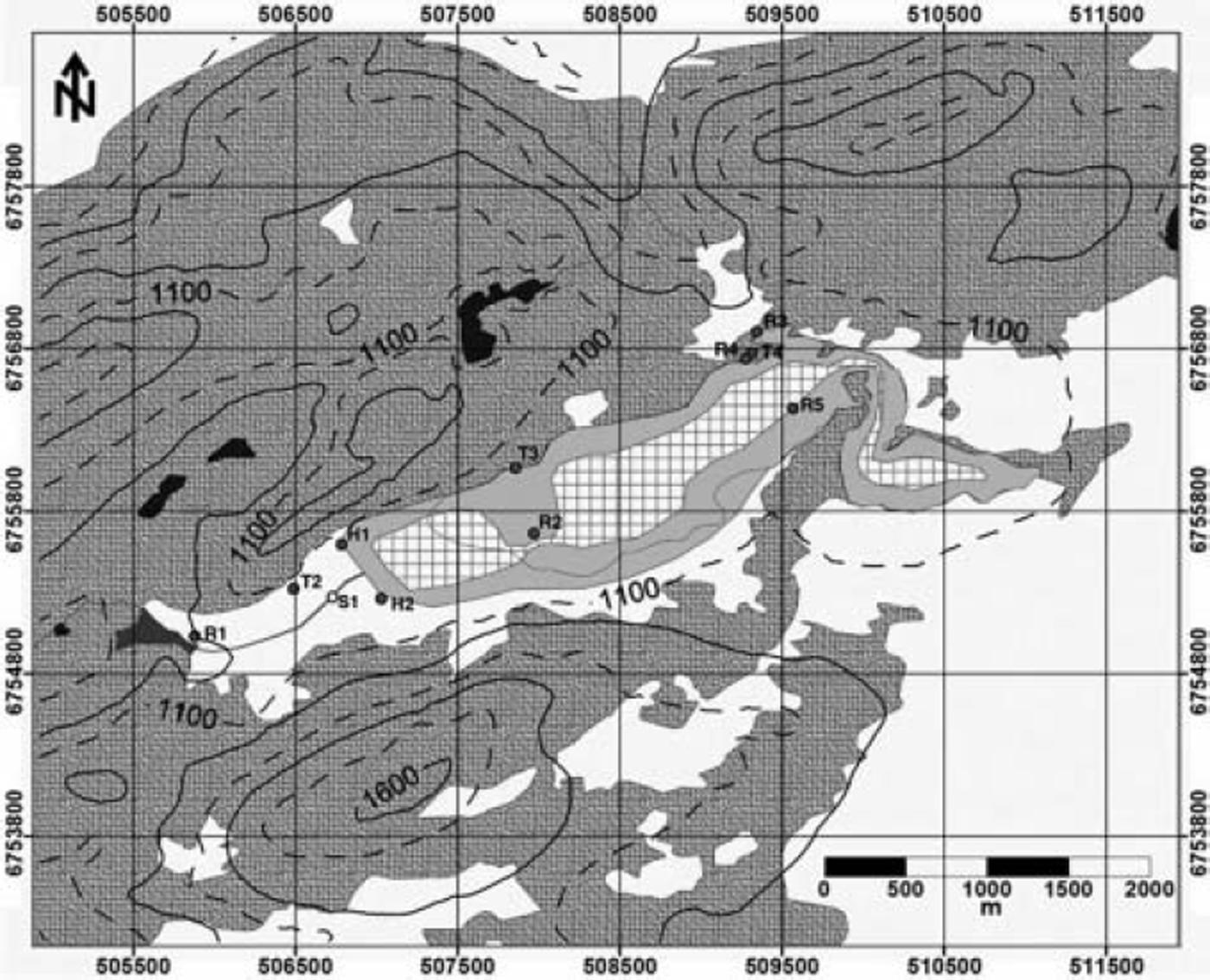
Primarily, the drainage-channel generation and potential dangers associated with the overtopping need to be assessed. To provide a data basis, the new glacier geometry and lake geometry was surveyed. As geographic reference and for use in a future aerial photogrammetric survey, several global positioning system (GPS) locations were marked as control points (Fig. 2). These GPS positions have been interconnected by a terrestrial survey, including the highest point of the ice dam, two positions at the old lake shore and one position each at the new lake shore and in the centre of the former spillway. The depth of the new gully, which now conducts the lake water towards Qorlortorssup tasia, was measured from the helicopter (location S1 in Fig. 2) with a rope down to the water level because ground-based measurements close to the gully edge were too dangerous.
Lake geometry before (light grey) and after (hatched area) the breaching event, including the positions of the terrestrial survey. The thin line inside the lake area indicates the lake margins in 1985. The former spillway of the lake was situated at position R3. Glacierized areas are shown in white, and other lakes in black. The map projection is UTM/WGS84 and the elevation contour interval is 100 m.
In addition to the measurements at the lake, a series of pictures taken from the shore and from the helicopter were used to extrapolate the point measurements in space. These pictures were also compared with aerial photographs from 1942 and the available electronic map, which is based on information from 1985 and a Landsat-5 scene from 1993 (Reference SchjøthSchjøth and others, 2000).
The accuracy of the GPS measurements lies within 5–10 m and is comparable with the accuracy of related features in the map (G/250 vector ©KMS (Danish Cadastral Survey), 1998). The uncertainty of the distance measurements using the total station is less than a few centimetres, whereas the vertical positioning is affected by refraction uncertainties. A comparison of independent height measurements of the old lake shore at two different positions (T3 and R4 in Fig. 2), relative to a fixed point (R2), showed a difference of only 25 cm over a distance of 1600 m. Thus, the accuracy of the vertical measurements is estimated to be better than 25-30cm. The gully depth measurement is affected by the uncertain height of the helicopter above the ice surface. The value of 48.5 m, however, should be accurate within 2 m. The uncertainty of the new lake surface area and of the corresponding lake volume, derived from the survey, is estimated to be 20%.
Lake Drainage
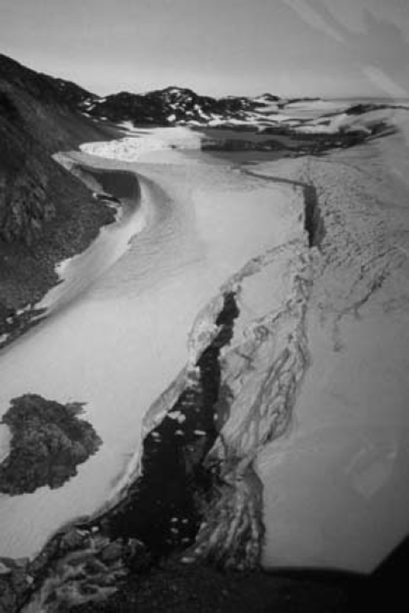
At the time of the survey, the outflow from the glacial lake into Qorlortorssup tasia basin was reduced to about the discharge corresponding to the inflow from the upstream glacial basin. The water flowed through a gully in the ice dam which is about 1100m long, 10-15 m wide and at maximum almost 50 m deep. Surface features of widespread water flow over the entire glacier length clearly indicated that the channel formation started by overtopping the glacial dam (Fig. 3).
Photograph of the drainage channel cut through the glacier, with the drained lake in the background. The partition into two lakes at different levels is apparent.
According to the analysis of available images and maps, the lake area increased from about 1.7 km2 in 1942 to 2.25 km2 in 1985. During the same time the front of the dam retreated roughly 1000 m, followed by a further retreat of 600 m between 1985 and 2003. The final maximum extent of the lake in 2003 was 2.9 km2. The length of the ice barrier, preventing the lake from draining into Qorlortorssup tasia basin, was reduced by 60% to 1100 m during this period. Over the last 11 years, the glacier surface melted down approximately 20 m, finally reaching the lake surface level. This corresponds to a net mass balance of -1.8 m a-1 , which is slightly more negative than the observed net mass-balance values at comparable altitudes on the south Greenland ice sheet (−1.4 m a-1 ; Reference Podlech, Mayer and BøggildPodlech and others, 2004). At present, the highest point of the glacier is only 1.8 m above the lake level at the onset of the flood, whereas the central part of the glacier is at least 2 m lower than the northern margin.
The former lake is now divided into two smaller basins (Fig. 2). The level of the larger, main lake is 27 m below the original lake level. The uppermost part, close to the margin of the ice cap, is divided into several smaller ponds, which are situated several metres higher than the main lake. The level of the smaller lake at the glacier dam is roughly 12 m below the main lake. This gives a height difference between the lower lake and the deepest part of the glacier gully of about 10 m. At the time of the visit, the water plunged over an ice spillway into the gully. If there is no bedrock or morainic threshold underneath the ice, the lake level of the smaller lake potentially could be reduced by a further 10 m, due to ongoing basal erosion/melting of the ice bed. The deepest part of the gully, however, is only a few metres higher than the final outlet, inhibiting further lowering of the lake level. Also, the water in the ice gully runs already over bedrock for more than half of the gully length, as observed from the helicopter.
The size of total lake surface area at the time of the visit was reduced to 1.18 km2, a reduction by almost 60% from the maximum extent. The smaller, lower lake accounts for only 0.25 km2. The total amount of water that drained within 8-10days after the onset of the flood was estimated to be about 55 × 106m3 . In case of a further reduction of the lower lake level by 10m, another 2 × 1 0 6m3 may have drained during the days following the visit, before the outflow stabilized. A minor water contribution can still be expected from melting of ice blocks that may break off the gully walls in future.
The Numerical Lake-Drainage Model
To reconstruct the temporal evolution of the flood, we used a numerical model, describing the lake drainage through an ice-walled channel which is progressively enlarged by melting as energy is dissipated by the water flow. For this purpose, we adopt the model of Reference Raymond and NolanRaymond and Nolan (2000) who report a similar lake drainage by overtopping the ice dam at Black Rapids Glacier, Alaska, USA. The model formulation implies a number of simplifying assumptions, which can be justified by the observations at the Qorlortorsuaq ice lake: The channel has constant slope a and the depth of the flowing water h is constant along the channel. We further assume that the channel has a rectangular cross-section, the width of which, B, is much larger than the water depth h. Enlargement occurs exclusively by down-melting the bottom of the channel. If the temperature of the lake water is above freezing, the temperature drops linearly to freezing at the exit of the channel.
For a channel with width B much larger than the depth of the flowing water h, the Manning-Strickler formula to describe discharge can be written
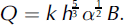
Here, k denotes the Strickler roughness coefficient. The water depth is given by h = zl − zc, the elevation difference between the lake level zl and the channel floor zc at the lake exit. Drainage occurs if zl > zc, otherwise Q = 0. From conservation of energy, we derive an expression for the evolution of z c

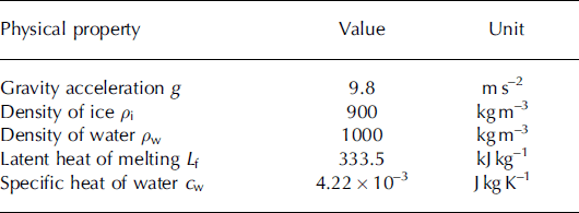
where ρw/i denote the densities of water and ice, respectively, g is acceleration due to gravity and L the latent heat of melting. Used values are given in Table 1. The temperature of the lake water above freezing, ΔT, drops linearly to zero along the length l, and c w is the specific heat of water. The evolution of zl is derived from the water balance of the lake,
Physical constants
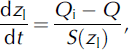
where Qi is input discharge to the lake and S(zl) is the lake surface area at water level zl.
Substituting Q in Equations (2) and (3) with Equation (1) yields a system of two ordinary differential equations which can be solved for the two unknowns z c and zl. The initial value problem was solved using an explicit Runga-Kutta method.
Initial Conditions and Parameter Values
The computation was started from the following initial condition: the lake level was equal to the elevation of the ice dam, zl = zc = 40 m relative to the outlet of the channel. The channel was 1100m long and its slope was 0.012. From photographs of the channel after termination of the flood (Fig. 3), we determined B = 10m. We selected k=30m1/3s–1 as a typical value for a mountain stream (e.g. Reference MaidmentMaidment, 1993). The hypsography of the lake was determined from a digital elevation model that was constructed from air photographs and the ground-based survey after the lake was emptied. Discharge input to the lake was roughly estimated Qi = 1 m3s–1.
Sensitivity
The temperature of the lake water, T, during the flood event is not known and we investigate the sensitivity of our model to changes in T. Reference Raymond and NolanRaymond and Nolan (2000) argued that unstable drainage occurs if the bottom of the channel through the ice dam drops faster than the water level in the lake. They analyzed this condition and derived an expression for the critical lake area which must be exceeded to enable unstable drainage. In the Qorlortorsuaq case, the lake surface area is well constrained by observations while estimates of the lake temperature are uncertain. Here, we analyze the stability of lake drainage as a function of lake temperature. If we neglect Qi and insert Equations (1-3) into dz c / dt > dzl/dt , the condition for unstable drainage, we obtain an expression for the critical lake temperature
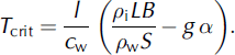
For the given situation, the critical lake temperature unstable drainage is estimated to be 0.25˚C. for
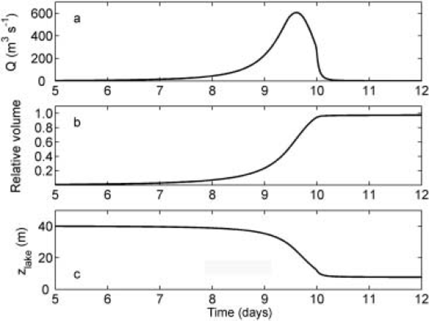
From the available observations, it is known that the evolution of the full channel depth lasted 5–10 days. This was deduced from the still rising level of Qorlortossup lake after 5 days and the fully developed channel found during the visit 8days after the onset of the flood. Considering the duration of the flood, we modelled a number of scenarios to constrain the temperature of the lake water and determine the most likely scenario for the breaching event. As a result, the model predicts that the lake temperature was around 0.45˚C. Model results obtained from using this value suggest that the flood reached a peak discharge of roughly 600 m 3 s–1 (Fig. 4a). Furthermore, the bulk of the water discharged within 6days, and 97% of the lake volume was drained roughly 10 days after the onset (Fig. 4b). At that time, the water level was about 8 m above the lake floor (Fig. 4c), and the still declining discharge was about 6 m 3 s–1.
Model results obtained from the most likely parameter configuration: (a) flood hydrograph; (b) the drained water volume V relative to the original lake volume; and (c) elevation of the lake water level z lake.
Reconstruction of the 2003 Flood
Observed trimlines in the area (e.g. Fig. 3, left mountain slope) show that during the last maximum ice extent, probably towards the end of the 19th century, the entire lake basin was filled with a glacier, which was then up to 100 m above the modern glacier surface. This glacier reached into the Qorlortorssup tasia basin, as well as into the adjacent Sermeq kangigdleq valley. During the general retreat of ice masses in south Greenland since the beginning of the 20th century (Reference WeidickWeidick, 1959), ice flow through the Qorlortorsuaq tributary ceased and the ice surface in the recent lake area lowered. The ice flow over the rock spillway into Sermeq kangigdleq was further reduced and the lake started to form, most likely during the 1920s. In 1942, the lake had reached about 6 0% of its final maximum size. After the ice dam lost connection with the main ice cap, it started to shrink since the equilibrium-line altitude in this area is about 150m above the modern ice surface (Reference Podlech, Mayer and BøggildPodlech and others, 2004).
Most likely, the water started to overtop the ice dam towards Qorlortorssup tasia during the last days of June 2003. This happened first on an approximately 100 m stretch of the glacier (Fig. 3). The water flow subsequently concentrated in a few erosion channels, which started to merge into one channel at the downstream end of the ice dam. This concentration of water flow eventually reached the lake shore, and further erosion/melting of the channel accelerated the process of channel enlargement. The reason why the ice dam did not become afloat is not entirely clear. Most probably the ice dam is frozen to the ground. Annual mean temperatures are only available for Qaqortoq (0.6˚C (Reference Hanna and CappelenHanna and Cappelen, 2003)), which indicates an annual mean temperature of approximately -5˚C at the lake. Because the ice dam is not dynamically active, such a mean surface temperature would be low enough for freezing conditions at the ice base.
Due to the length across the ice dam (approximately 1100 m), a catastrophic outburst by a mechanical failure of the ice dam or an isostatic uplift of the ice mass did not occur. Instead, the downward erosion of the drainage gully caused a progressively increasing discharge from the lake. Further downstream, the flood was reduced by the retention of the Qorlortorssup tasia basin, which measures 23 km in length from the glacier.
For glacier outburst floods, Reference Clague and MathewsClague and Mathews (1973) established the relation Qp = aVb to estimate the peak discharge Q p based on the lake volume V (in 106m3s–1) (Reference Ng and BjörnssonNg and Björnsson, 2003). Reference Walder and CostaWalder and Costa (1996) determined the parameter values a = 46 and b = 2/3 for outburst floods through a subglacial channel and a= 1100 and b = 0.44 for floods through a subaerial breach. Using both parameter sets and V = 55 for Qorlortossup tasia, we obtain 675 m3 s–1 and 6415m3s–1, respectively. The first value is in close agreement with the ∼600m3s–1 of our reconstruction (Fig. 4a), while the second value overestimates Q p by one order of magnitude. We explain this behavior with the qualitative similarity of drainage through a subglacial channel and through the subaerial channel at Qorlortossup tasia. In both cases, the evolution of an outburst flood is controlled by melting of the channel walls due to viscous dissipation of the water flow, while Reference Walder and CostaWalder and Costa (1996) considered subaerial outbursts which were controlled by a mechanical failure of the ice dam. This is also supported by the negative skewness of the hydrograph in Figure 4a, indicative for a flood pathway that is progressively enlarged during the flood.
We believe that the channel is kept open as long as there is some water flow through it. During winter, the water discharge will cease due to the low temperatures prohibiting meltwater production, and the channel may close by ice creep. We estimated the closure rate based on a simple evaluation of the geometry of the gully and prevailing ice conditions (close to the melting point). With a simple but appropriate assumption of simple shear (Reference PatersonPaterson, 1994, p.259ff.), the horizontal velocity ux changes with depth z according to
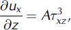
where A is the rate factor in Glen’s flow law for ice and Txz is the shear stress. In this case, Txz is given by the hydrostatic pressure of the overburden ice. Evaluating Equation (5) over an ice depth of 40 m and using A = 3.0 × 10⁻¹⁵kPa–3, we find that during one winter period the strain rate is large enough only to close the lowermost 15 m of the 10 m wide gully. The winter of 2003/04 has shown that snowdrift into the gully led only to a partial filling of the gully which was not enough to retain considerable amounts of water (personal communication from R. Andersen, 2004). Therefore, we exclude the occurrence of a flood comparable in size to the observed event for the near future, as long as the prevailing climatic conditions exist.
Before the 2003 outburst, the local glacier contributed only small quantities of meltwater to the catchment of Qorlortorssup tasia (in the order of 105m3a–1). Now, the entire drainage basin of the glacier lake contributes to Qorlortorssup tasia. Previous estimates yielded a potential annual contribution of roughly 14 × 106m3 (personal communication from O.B. Olesen, 2003). However, the area on the ice cap, which drains towards the ice lake, is poorly constrained, and the actual water contribution into the Qorlortorssup tasia basin might be considerably larger.
Conclusions
The observed flood from the Qorlortorsuaq ice-dammed lake during July 2003 was a consequence of continuous glacier recession. After the separation of the ice dam from the feeding ice cap, it cannot be maintained under present climate conditions. The water impounded in the lake overtopped the ice dam and created a gully through which almost the entire lake emptied within 10days. Fortunately, human settlements were far enough from the lake not to be threatened by this event. A complete closure of the eroded gully is very unlikely and the new drainage pattern will persist. Therefore, the potential flood hazard in the Qorlortorssup tasia area is small. The increase in water supply for the planned hydropower plant might be up to 3050% of the discharge over the waterfall of Qorlortorsuaq before the flood. The effect of additional glacial meltwater contribution during the summer months should be taken into account in the design of the hydropower plant.
Acknowledgements
T.V. Schuler gratefully acknowledges a grant of the Deutsche Forschungsgemeinschaft. C. Mayer thanks Greenland Resources A/S for enabling fieldwork at the glacier lake. We further appreciate the comments of M. Funk, H. Björnsson and N. Reeh (Scientific Editor) which helped to improve an earlier version of the paper.



