


INTRODUCTION
Loess deposits that accumulated chiefly during the last glacial maximum (LGM; Clark et al., Reference Clark, Dyke, Shakun, Carlson, Clark, Wohlfarth, Mitrovica, Hostetler and McCabe2009) in the North American midcontinent are known stratigraphically as the Peoria Silt or Peoria Loess (Willman and Frye, Reference Willman and Frye1970; Hansel and Johnson, Reference Hansel and Johnson1996; Bettis et al., Reference Bettis, Muhs, Roberts and Wintle2003; Muhs et al., Reference Muhs, Bettis and Skipp2018). The Peoria Silt is ubiquitous across uplands from Colorado to Ohio and from Minnesota to Louisiana (Thorp and Smith, Reference Thorp and Smith1952; Ruhe, Reference Ruhe1984; Follmer, Reference Follmer1996; Bettis et al. Reference Bettis, Muhs, Roberts and Wintle2003). Significantly, these loess deposits serve as the parent material for some of the most productive agricultural soils in North America (Fehrenbacher et al., Reference Fehrenbacher, Jansen and Olson1986; Catt, Reference Catt2001). A more precise understanding of the chronology of Peoria Silt deposition, along meltwater valleys segments with contrasting glacial history, is important for providing context to studies of paleoclimate (Muhs et al., Reference Muhs, Bettis, Roberts, Harlan, Paces and Reynolds2013; Conroy et al., Reference Conroy, Karamperidou, Grimley and Guenthner2019), terrestrial gastropod fossils (Baker, Reference Baker1936; Leonard and Frye, Reference Leonard and Frye1960; Grimley et al., Reference Grimley, Counts, Conroy, Wang, Dendy and Nield2020), mammalian fossils (Treworgy et al., Reference Treworgy, Saunders and Grimley2007; Saunders et al., Reference Saunders, Grimm, Widga, Campbell, Curry, Grimley, Hanson, McCullum, Oliver and Treworgy2010), loess–stratigraphy correlations (Frye et al., Reference Frye, Glass and Willman1968; Mason et al., Reference Mason, Joeckel and Bettis2007), soil genesis (Ruhe, Reference Ruhe1984; Muhs et al., Reference Muhs, Bettis, Been and McGeehin2001), archaeology (Van Nest, Reference Van Nest1993), and soil chronosequences (Schumacher et al., Reference Schumacher, Miller and Day1987). Geochronology can also help determine the extent to which loess deposition is connected with the geologic history and fluctuations of sediment-rich glacial lobes of the southern Laurentide Ice Sheet (Curry, Reference Curry1998; Grimley, Reference Grimley2000; Ullman et al., Reference Ullman, Carlson, LeGrande, Anslow, Moore, Caffee and Syverson2015; Curry et al., Reference Curry, Lowell, Wang, Anderson, Kehew and Curry2018; Heath et al., Reference Heath, Loope, Curry and Lowell2018; Dendy et al., Reference Dendy, Guenthner, Grimley, Conroy and Counts2021) or to what extent loess accumulation is driven directly by climatic change (Wang et al., Reference Wang, Follmer and Liu2000; Muhs et al., Reference Muhs, Bettis, Roberts, Harlan, Paces and Reynolds2013).
Since the mid-twentieth century, the Peoria loess, and older loess deposits, in areas along the Mississippi and Illinois River valleys have been genetically related to periods of glaciation and advance of glacial lobes in the upper Midwest (Smith, Reference Smith1942; Leighton and Willman, Reference Leighton and Willman1950; McKay, Reference McKay1979; Follmer, Reference Follmer1996; Grimley, Reference Grimley2000; Nash et al., Reference Nash, Conroy, Grimley, Guenthner and Curry2018; Muhs et al., Reference Muhs, Bettis and Skipp2018). In some areas of northeast Iowa and southeast Minnesota, the Peoria loess is associated with deflation from the Iowan Erosion Surface (Mason et al., Reference Mason, Nater and Hobbs1994; Bettis et al., Reference Bettis, Muhs, Roberts and Wintle2003; Mason, Reference Mason2015). In the more semiarid regions of Nebraska and Kansas, west of the Missouri River valley region, the Peoria loess is nonglacial in origin, although it was also deposited during the last glaciation (Mason, Reference Mason2001; Aleinikoff et al., Reference Aleinikoff, Muhs, Bettis, Johnson, Fanning and Benton2008). In the midcontinental areas with glacigenic loess, the fine fraction of glacial outwash was deflated from broad river valleys and generally accumulated on vegetated uplands. The thickest loess was deposited on uplands along the eastern or southeastern bluffs of major river valleys that served as glacial meltwater outlets, such as the Mississippi, Missouri, Illinois, Wabash, and Ohio River valleys (Smith, Reference Smith1942; Thorp and Smith, Reference Thorp and Smith1952; Bettis et al., Reference Bettis, Muhs, Roberts and Wintle2003). Along these valleys, model simulations of LGM winds, as well as loess thickness patterns, suggest persistent westerly winds that were stronger during the LGM compared with the modern preindustrial period (Conroy et al., Reference Conroy, Karamperidou, Grimley and Guenthner2019).
The type area of the Peoria Silt (also Peoria Loess, formerly Peorian loess) is named for the town of Peoria in Illinois (Leverett, Reference Leverett1898; Alden and Leighton, Reference Alden and Leighton1917) and was formally adopted as a lithostratigraphic unit in Illinois by Frye and Willman (Reference Frye and Willman1960). The term Peoria Silt was adopted in Illinois by Hansel and Johnson (Reference Hansel and Johnson1996) in an effort to remove genetic terms from Quaternary lithostratigraphic units. The chronology of the Peoria Silt began to be studied soon after the beginning of radiocarbon dating in the mid-1950s. Early radiocarbon ages were reported by Frye and Willman (Reference Frye and Willman1960), Leonard and Frye (Reference Leonard and Frye1960), and Frye et al. (Reference Frye, Glass and Willman1962). Based on a limited number of radiocarbon ages and extrapolation to the surface, a loess cessation age was estimated at ~14 ka (12 14C ka BP) for loess along the Mississippi Valley in northwestern Illinois and ~17 ka (14 14C ka BP) for loess in the Illinois Valley region (Frye et al., Reference Frye, Glass and Willman1968). Differences in loess cessation were suspected to have resulted from contrasting glacial histories in these watersheds, with glacial lobes in the upper Mississippi Valley continuing to provide sediment after the Lake Michigan Lobe receded (Frye et al., Reference Frye, Glass and Willman1968; McKay, Reference McKay1979). Data from McKay (Reference McKay1979) suggested a basal age of ~29 ka (25 14C ka BP) immediately above the Roxana Silt and an upper age of ~15 ka (12.5 14C ka BP). Other research focused on dating weak paleosols within the Peoria loess (Frye et al., Reference Frye, Leonard, Willman, Glass and Follmer1974).
More recent loess studies in Illinois (Grimley et al., Reference Grimley, Follmer and McKay1998; Wang et al. Reference Wang, Follmer and Liu2000; Pigati et al., Reference Pigati, McGeehin, Muhs, Grimley and Nekola2015; Nash et al., Reference Nash, Conroy, Grimley, Guenthner and Curry2018; Muhs et al., Reference Muhs, Bettis and Skipp2018; Miao et al., Reference Miao, Hanson, Stohr and Wang2018) have provided higher-resolution chronologies in relation to loess zonations or interstadial paleosols. Yet different age methods (gastropod shell 14C, disseminated organic matter, volatile 14C, luminescence) have led to different published chronologies, particularly for the cessation of Peoria loess deposition. From the 15-m-thick Keller Farm Section in southwestern Illinois, Wang et al. (Reference Wang, Follmer and Liu2000) suggested Peoria Silt deposition between ~27 and 13 ka (and as young as 10 ka by extrapolation up through the modern soil) based on radiocarbon dating of the pyrolysis-volatile fraction of organic matter. Based on terrestrial gastropod shell dating by accelerator mass spectrometry (AMS) radiocarbon methods, Pigati et al. (Reference Pigati, McGeehin, Muhs, Grimley and Nekola2015) and Nash et al. (Reference Nash, Conroy, Grimley, Guenthner and Curry2018) reported ages for the Peoria Silt between 29 and 20 ka along the Illinois and lower Mississippi Valleys. Based on extrapolation through the leached modern soil, Nash et al. (Reference Nash, Conroy, Grimley, Guenthner and Curry2018) suggest a loess cessation age between 18 and 16 ka in the Illinois Valley region. In the upper Mississippi Valley region, Pigati et al. (Reference Pigati, McGeehin, Muhs, Grimley and Nekola2015) and Muhs et al. (Reference Muhs, Bettis and Skipp2018) reported a shell age as young as 18.8 ka, more than 1 ka younger than shell ages in loess to the south, suggesting that loess deposition continued later in this region. The possible presence of Holocene loess in Illinois was suggested by Miao et al. (Reference Miao, Hanson, Stohr and Wang2018). However, whether optically stimulated luminescence (OSL) ages in the surficial meter of soil represent a loess depositional age is controversial (Grimley et al., Reference Grimley, Curry, Nash and Huot2019). The accumulation of any Holocene loess was likely minimal and would have essentially become mixed into the modern soil profile.
From several recent studies, it has been found that most small (<1 cm) terrestrial gastropods can provide accurate and precise ages for loess sedimentation within a few hundred years resolution (Pigati et al., Reference Pigati, Rech and Nekola2010, Reference Pigati, McGeehin, Muhs and Bettis2013, Reference Pigati, McGeehin, Muhs, Grimley and Nekola2015; Újvári et al., Reference Újvári, Molnár, Novothny, Páll-Gergely, Kovács and Várhegyi2014; Gu et al., Reference Gu, Lu, Hajdas, Haghipour, Zhang, Wu and Shao2023). Whereas Succineidae, Discus sp., Allogona sp., and other genera provide accurate ages, some large genera, such as Mesodon sp. (>20 mm), are known to provide erroneous ages that can be >1 ka too old (Rakovan et al., Reference Rakovan, Rech, Pigati, Nekola and Wiles2010; Pigati et al., Reference Pigati, McGeehin, Muhs, Grimley and Nekola2015) and should be avoided. In last glacial palustrine (former wetland) sediments of central Indiana, comparisons of radiocarbon ages from terrestrial gastropods (Succineidae, Discus) with those from plant macrofossils in the same stratigraphic layers show good correspondence (Loope et al., Reference Loope, Antinao, Monaghan, Autio, Curry, Grimley, Huot, Lowell, Nash and Florea2018; this study). Terrestrial gastropods are locally abundant in thick last glacial loess deposits (>5 m), proximal to the valley bluffs of major river valleys in the central United States such as the Illinois Valley, Ohio Valley, and Mississippi Valley (Baker, Reference Baker1936; Leonard and Frye, Reference Leonard and Frye1960; Nash et al., Reference Nash, Conroy, Grimley, Guenthner and Curry2018; Grimley et al., Reference Grimley, Counts, Conroy, Wang, Dendy and Nield2020). Based on two recent studies, loess accumulation rates average ~1 mm/yr or more in loess zones that have complete (identifiable) gastropod shells preserved (Nash et al., Reference Nash, Conroy, Grimley, Guenthner and Curry2018; Grimley et al., Reference Grimley, Counts, Conroy, Wang, Dendy and Nield2020). In loess with accumulation rates ≤0.5 mm/yr, the shells are probably not buried quickly enough to be fully protected from carbonate dissolution or leaching processes.
The objectives of this study are to refine the Peoria Silt chronology in thick loess along the Illinois, Mississippi, Wabash, and Ohio River valleys. To this end, we use suitable terrestrial gastropod taxa (such as Succineidae, Discus) to provide accurate radiocarbon ages. As further tests of the accuracy of terrestrial shell ages, co-occurring last glacial fossil shells and organic material from sites in central Indiana and historically collected gastropods from Illinois were both radiocarbon dated. From gastropod-based loess chronologies, we explore differences in loess accumulation timing and rates among different valley segments within and along the margins of Illinois. We also reexamine the hypothesized young (late glacial) Peoria Silt chronology at the Keller Farm Section (Wang et al. Reference Wang, Follmer and Liu2000, Reference Wang, Hughes, Steele, Lepley and Tian2003), using numerous terrestrial shell AMS 14C ages from the original section from a new borrow pit ~0.5 km east and from another loess section 22 km southward. We present new gastropod shell ages from Peoria loess along the Mississippi Valley in western Illinois (Lomax Section) and from loess immediately above LGM till deposits in central Illinois. We also report shell ages from two new study sites (Terre Haute Core, OLT-2) along the Wabash Valley. Finally, we compile these new ages along with recently published, high-resolution, Peoria Silt shell-based radiocarbon chronologies from Muhs et al. (Reference Muhs, Bettis and Skipp2018), Nash et al. (Reference Nash, Conroy, Grimley, Guenthner and Curry2018), and Grimley et al. (Reference Grimley, Counts, Conroy, Wang, Dendy and Nield2020) to provide a revised working model for the timing and environmental forcings of Peoria Silt accumulation in Illinois. Ultimately, an improved chronology of Peoria Silt will aid in understanding the drivers of loess deposition, improve paleoclimate interpretations from these loess deposits, and help support correlations between variations in regional loess deposition rates and potential large-scale climate forcings of loess deposition.
GEOLOGIC BACKGROUND: KEY SITES FOR LOESS CHRONOLOGY
The sites listed here are a combination of previously studied loess sites with gastropod shell AMS-radiocarbon chronologies and new fossiliferous loess sites that were studied and dated as part of this project. The sites are generally listed from northwest to southeast, with the exception of ABL-28 and ABL-54. Prior chronologies from published loess sites (Morrison Section, Cottonwood School Section, Thomas Quarry, Rocks Section; Fig. 1) are summarized here, whereas shell ages from newly studied sites (Demazenod Section, Terre Haute Loess Core, OLT-2; Fig. 1) are presented in the “Results.” Two sites (Lomax Section and Keller Farm [original]) were previously studied, but include new chronological data reported here. In addition to the loess sites, we investigated three sites in central Indiana (Clayton Section, Plainfield Section, Ward Quarry) to compare radiocarbon ages for co-occurring terrestrial gastropod shells and wood. The loess sites were selected to represent Peoria loess deposits on various major valley segments within and on the margin of Illinois (Fig. 1). Representative sites are selected from areas proximal to the upper Mississippi Valley (Morrison Section, Lomax Section), the Illinois Valley (Cottonwood School, Thomas Quarry), the mid-Mississippi Valley (Keller Farm Section, Demazenod Section), and the Wabash-Ohio Valleys (Terre Haute Core, OLT-2, Rocks Section). All selected sites are well studied, have abundant fossil terrestrial gastropods, and have solid stratigraphic frameworks. With the exception of the Rocks Section and OLT-2, sites were sampled at hillcrests with stable modern surface profiles or where erosion of the surficial loess is likely minimal.
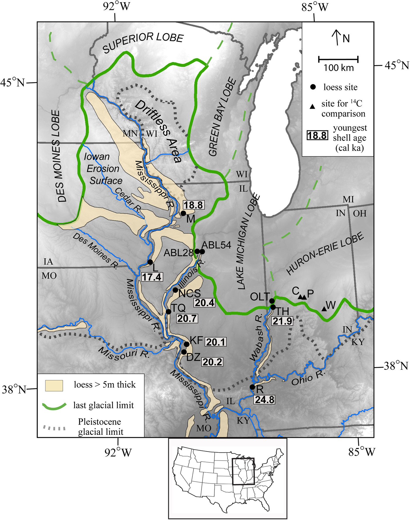
Figure 1. Location of 12 studied fossiliferous loess sites in the Central Lowlands, United States, with respect to areas of thick loess (>5 m) and glacial lobes of the Wisconsin Episode. The locations of three sites in central Indiana, used for comparing last glacial shell and organic 14C ages, are also shown. M = Morrison Section; L, Lomax Section; NCS, New Cottonwood School; TQ, Thomas Quarry; KF, Keller Farm (and New Keller Farm); DZ, Demazenod Section; R, Rocks Section; TH, Terre Haute Core; OLT, OLT-2 Section; C, Clayton Section; P, Plainfield Section; W, Ward Quarry. Inset map shows location within United States.
In areas with thick Peoria loess in Illinois, the unit is a dominantly tan to grayish brown, silt-rich deposit (~80 to 90% silt, 10 to 20% clay, and < 5% very fine sand). Munsell colors in oxidized loess, in well-drained landscape positions, are typically yellowish brown (10YR 5/4). Weak paleosols (likely interstadial) may occur within the loess unit (Frye et al., Reference Frye, Leonard, Willman, Glass and Follmer1974; McKay, Reference McKay1979; Wang et al, Reference Wang, Follmer and Liu2000; Nash et al., Reference Nash, Conroy, Grimley, Guenthner and Curry2018). In loess proximal to the Illinois Valley and middle Mississippi Valley, the Peoria Silt has been informally divided into lower, middle, and upper zones based on lithology, paleosols, and magnetic susceptibility values (Grimley et al., Reference Grimley, Follmer and McKay1998). The lower-middle Peoria Silt boundary, associated with a dramatic shift in magnetic susceptibility (Grimley et al., Reference Grimley, Follmer and McKay1998), is coincident with the diversion of the Mississippi River to its present course at ~24.4 ka (Curry, Reference Curry1998). The Jules Geosol, a minor intra–Peoria Silt paleosol (Frye et al., Reference Frye, Leonard, Willman, Glass and Follmer1974), is found at and immediately below the middle-upper Peoria Silt boundary in loess along the bluffs of the Illinois Valley and has been noted along the bluffs of the Mississippi Valley in Illinois east of St. Louis.
Morrison Section
The Morrison Section in northwestern Illinois was previously studied and dated by Muhs et al. (Reference Muhs, Bettis and Skipp2018). The total thickness of the Peoria Silt is 16.7 m, which overlies 1.7 m of Roxana Silt, which in turn overlies the Sangamon Geosol (the last interglacial paleosol). Muhs et al. (Reference Muhs, Bettis and Skipp2018) report four Succineidae shell ages in the Peoria Silt, ranging from 18.8 ± 0.1 to 23.8 ± 0.3 ka, at depths of 3.35 to 14.5 m below ground surface. The Morrison Section was also studied by Frye et al. (Reference Frye, Glass and Willman1968), McKay (Reference McKay1977), and Pigati et al. (Reference Pigati, McGeehin, Muhs, Grimley and Nekola2015).
Lomax Section
This section, in western Illinois on the eastern bluffs of the Mississippi Valley, was studied in detail by Curry (Reference Curry1998). Two gastropod shell ages (on unknown species) in the Peoria Silt were reported by Oches et al. (Reference Oches, McCoy and Clark1996), but one age has >500 yr 1-sigma error. Four additional shell ages on Succineidae (Fig. 2A) were determined as part of the current study (site description in Supplementary Table S1); two ages below the modern soil and two ages above the basal contact. The section is also noted in Illinois State Geological Survey archived field notes (Frye, J.C., Leonard, A.B., 1950s). At the Lomax Section, 11.5 m of Peoria Silt overlies 4.8 m of Henry Formation (sandy outwash), which overlies 3.5 m of Equality Formation (lake sediment) that overlies organic-rich sediment of the Robein Member, Roxana Silt below. The section was notable because the lake sediment marks the beginning of the Mississippi River diversion to its present course at 24.4 ka (20.35 14C ka BP; Curry, Reference Curry1998). Shell ages reported from Oches et al. (Reference Oches, McCoy and Clark1996) are 16.2 ± 0.6 14C ka BP (19.6 ± 2.6 ka; GX-15444), about a meter above the base of Peoria Silt and 12.0 ± 0.1 14C ka BP (13.9 ± 0.3 ka; AA-3620) immediately below the modern soil (~1 m depth). Because both shell taxa are unknown, the older shell age (calibrated) has >2 ka error, and the cleaning procedure for the younger shell is not known (Oches et al., Reference Oches, McCoy and Clark1996), these two shell ages were not included in our analysis. Thus, only the four new Succineidae shell ages were used.

Figure 2. Photos of fossil terrestrial gastropod shells from last glacial Peoria Silt (loess): (A) Succineidae from Lomax Section, (B) Webbhelix multilineata from Demazenod Section, (C) Stenotrema barbatum from Rocks Section, and (D) Succineidae from ABL-28. Shells range in size from 5 to 20 mm.
Cottonwood School and Thomas Quarry Sections
These two sections are in thick last glacial loess on the eastern bluffs of the Illinois River valley. The Cottonwood School Section was originally studied by Leonard and Frye (Reference Leonard and Frye1960) and Frye et al. (Reference Frye, Glass and Willman1962). It was later reexamined by Frye et al. (Reference Frye, Leonard, Willman, Glass and Follmer1974) and Grimley et al. (Reference Grimley, Follmer and McKay1998); the latter study had three terrestrial shell radiocarbon age determinations of 13.0 ± 0.1 14C ka BP (15.5 ± 0.3 ka), 17.7 ± 0.1 14C ka BP (21.4 ± 0.4 ka), and 17.7 ± 0.1 14C ka BP (21.4 ± 0.4 ka). The two lower (older) ages are within the Jules Geosol zone. However, the uppermost age is now suspected to be too young, likely due to incomplete cleaning of secondary carbonate. A new gully exposure, known as New Cottonwood School Section, was studied by Nash et al. (Reference Nash, Conroy, Grimley, Guenthner and Curry2018), who provided a detailed chronology of the upper and middle Peoria Silt based on numerous terrestrial gastropod shells.
The Thomas Quarry Section was originally studied by Grimley et al. (Reference Grimley, Follmer and McKay1998). Two age determinations from terrestrial gastropods were not published in the original manuscript but are published in Nash et al. (Reference Nash, Conroy, Grimley, Guenthner and Curry2018). Nash et al. (Reference Nash, Conroy, Grimley, Guenthner and Curry2018) provide a detailed chronology of the Peoria Silt (and Jules Geosol zone) from Cottonwood School and Thomas Quarry Sections based on additional radiocarbon ages on 22 Succinea shells, 2 Webbhelix multilineata shells, and 2 other terrestrial shells. Collectively, the ages range between 27.8 ± 0.2 and 20.4 ± 0.2 ka. The Jules Geosol zone formed between about 23.7 and 22.2 ka, based on these data. The end of significant loess deposition is extrapolated to either 18 or 16 ka along the Illinois River valley, based on models of sediment accumulation rates (Nash et al., Reference Nash, Conroy, Grimley, Guenthner and Curry2018).
Keller Farm Sections
The original Keller Farm Section was studied by Wang et al. (Reference Wang, Follmer and Liu2000, Reference Wang, Hughes, Steele, Lepley and Tian2003), but is no longer well exposed or easily accessed. The Peoria Silt at this site is about 15 m thick and overlies >2 m of Roxana Silt (base of unit not exposed). Among the thickest and most continuous Peoria loess sites studied in Illinois, the Keller Farm Section includes several interstadial or incipient paleosols (A/C horizons) within the section (Wang et al., Reference Wang, Follmer and Liu2000). Eleven radiocarbon ages were reported to range from 27.2 to 13.3 ka (22.8–11.4 14C ka BP in Wang et al. [2000]). However, these ages were from volatile soil organic matter, and it is now suspected that some of the ages, in particular at shallow depths (where tree roots are abundant), could have been contaminated by downward percolation of modern soil organic carbon. To test this, we acquired 21 new radiocarbon ages on terrestrial shells for comparison with the original soil organic matter ages.
The New Keller Farm Section exposed about 3.3 m of upper Peoria Silt in 2021 (Supplementary Table S1). This site is about 500 m east of the original Keller Farm Section. Three Succineidae shells were collected from the new site and dated. These ages provide an additional test for the age of the youngest Peoria Silt in this area.
Demazenod Section
This section was studied and sampled in 2016; it was an excavation for a construction project near Demazenod Drive in St. Clair County, southwestern Illinois. The site exposed Peoria loess deposits for tens of meters laterally and had abundant terrestrial gastropods visible in the field. Findings from this site are first presented here (field description in Supplementary Table S1). The site contains 4.25 m of Peoria Silt with the modern soil solum (A, E, Bt horizons) developed in the upper 1.2 m of loess. The site contains fossil gastropods in loess below 1.25 m, with 17 terrestrial species identified. Three Webbhelix multilineata (Fig. 2B) and one Succinea sp. were radiocarbon dated at this site. Based on previously determined loess thickness in this area from subsurface boring records and outcrops (Grimley and McKay, Reference Grimley and McKay2004), this section only exposes about the upper one-third of the Peoria Silt.
OLT-2 Section (loess below Tiskilwa Formation)
The OLT-2 Section (on Ouabache Land Conservancy property) is an outcrop exposed on the valley wall of a small stream draining an isolated upland known as Atherton Island. Atherton Island forms the east valley wall of the Wabash Valley and contains an exposure with loess deposits intermixed with thick Pleistocene glacial till units (Supplementary Table S1). This section, starting from the base, exposes Illinois Episode till (Vandalia Member, Glasford Formation; also known as Jessup Formation in Indiana), the Sangamon Geosol developed into the till, Roxana Silt deposited conformably on the Sangamon Geosol, the Morton Tongue of the Peoria Silt (loess; Hansel and Johnson, Reference Hansel and Johnson1996), and Wisconsin Episode till (Tiskilwa Formation) at the top of the section. The section lies less than 2 km within the Wisconsin Episode limit (terminal moraine) of the Lake Michigan Lobe, which reached its maximum at ~24 ka (Curry et al., Reference Curry, Lowell, Wang, Anderson, Kehew and Curry2018). The loess units (Peoria and Roxana Silts) that directly underlie the till display no evidence of deformation from being overridden by the ice. Loess was sampled in large volumes from the lower, middle, and upper third of the Morton Tongue (Peoria Silt) to sieve for gastropods.
Terre Haute Loess Core
This 5.5 m core in Peoria Silt (Supplementary Table S1) was collected in 2021 in loess-covered uplands on the east side of the Wabash River valley bluffs. The site is level and located within 130 m laterally of the bluff crest above an outwash terrace of the Wabash River. A hydraulic soil-coring machine was used to collect 5- or 8-cm-diameter core samples until saturated conditions prevented sample recovery. Based on scattered coarse fragments in basal Peoria Silt, the boring likely ends close to the contact with the Roxana Silt or Illinois Episode till. A former road cut nearby similarly exposed 5.8 m of Peoria Silt (site 2 in Fehrenbacher et al. [Reference Fehrenbacher, White, Ulrich and Odell1965]). A typical Alfisol profile (modern soil solum) occurs from 0 to 1.5 m. Yellowish-brown to gray fossiliferous loess (Peoria Silt) was encountered from 1.5 to 2.55 m, with secondary carbonate and some stratification. Six gastropod genera were found in this zone, including Succineidae, Stenotrema sp., Vertigo elatior, and Hendersonia occulta. Two amphibious taxa present, Galba sp. and Pomatiopsis lapidaria, suggest temporary wetland conditions or ponding in an upland depression. From 2.7 to 3.0 m and 3.3 to 3.8 m are stratified very fine sand (eolian) zones intercalated into silty loess Peoria Silt extending to 5.5 m. The loess from 2.5 to 5.5 m contains fewer gastropods than in the upper fossiliferous zone.
Rocks Section
This site, in western Kentucky adjacent to southeastern Illinois, provides a detailed chronology for loess deposits derived from the Ohio-Wabash River valleys. A detailed study of the chronology, gastropod assemblage, shell isotopes, and paleoclimate was provided by Grimley et al. (Reference Grimley, Counts, Conroy, Wang, Dendy and Nield2020). A nearby site was also studied by Leonard and Frye (Reference Leonard and Frye1960). At the Rocks Section, 7.95 m of Peoria Silt overlies 1.05 m of Roxana Silt, which overlies the Sangamon Geosol. Twelve radiocarbon dates on terrestrial gastropod shells (Discus, Stenotrema [Fig. 2C], Hendersonia) and one charcoal age range between 30 and 24.8 ka (Grimley et al., Reference Grimley, Counts, Conroy, Wang, Dendy and Nield2020). Loess dated 29 to 30 ka is transitional to the Roxana Silt. Due to the sloping and erosional topography in this area, it is suspected that the upper part of the Peoria Silt was eroded at this site; this likely explains the lack of younger shell ages (Grimley et al., Reference Grimley, Counts, Conroy, Wang, Dendy and Nield2020).
ABL-28 and ABL-54 (loess above Tiskilwa Formation)
Terrestrial gastropod shells from two locations from the A. Byron Leonard Pleistocene mollusk collection (Prairie Research Institute, University of Illinois) were used. Both sites are north of Peoria, Illinois, and consist of Peoria loess immediately above LGM till deposits. Well-preserved shells of Succineidae (Fig. 2D) were selected for age dating from sites ABL-28 and ABL-54. Site ABL-28 was a 4.6 m exposure (road cut) near the top of a hill on Hallock Hollow Road about 25 km north of Peoria, Illinois, and west of the Illinois River valley. The exposure contained Peoria Silt (loess) over Tiskilwa Formation till. Based on field notes of A. Byron Leonard, a 3 cm layer of waterlain or colluvial sediment occurred at the contact between the loess and till. The loess was calcareous and fossiliferous in the lower part, where it had been sampled. The till was slightly pinkish, calcareous, and did not show weathering at the top, implying cold conditions and/or little time before loess deposition. Site ABL-54 is ~13 km east of ABL-28 and exposed about 3 m of Peoria Silt over a pinkish calcareous till unit (Batestown Member, Lemont Formation or Tiskilwa Formation), deposited during the LGM. The site was on a bluff near Dry Creek, east of the Illinois River valley. The loess was fossiliferous in the lower part, above the till.
Clayton Section, Plainfield Section, and Ward Quarry (Indiana)
Terrestrial gastropod shells (predominantly Succineidae) from these three central Indiana sites (Fig. 1) were radiocarbon dated to compare with ages from organic material at the same sites. The Clayton Section is a 15-m-high exposure with two last glacial tills separated by a few meters of fossiliferous silt and glacifluvial sand (Loope et al., Reference Loope, Antinao, Monaghan, Autio, Curry, Grimley, Huot, Lowell, Nash and Florea2018). The lower till (Center Grove Member, Trafalgar Formation) is interpreted to represent a deposit of the maximum Wisconsin Episode advance, and the upper till (Cartersburg Member, Trafalgar Formation) is interpreted to represent a later readvance (Wayne, Reference Wayne1963; Loope et al., Reference Loope, Antinao, Monaghan, Autio, Curry, Grimley, Huot, Lowell, Nash and Florea2018). The fossiliferous silts contain a co-occurring Dryas leaves, Picea needles, other organics, and terrestrial gastropod shells (including Succineidae, Vertigo, Gastrocopta, and Discus) preserved in what is interpreted to be a palustrine or wetland deposit. The Cartersburg Member till and fossiliferous silts below are also found at the Plainfield Section (15 km east) and Ward Quarry (75 km southeast). Descriptions of the Plainfield and Ward Quarry sections are presented in Supplementary Table S1.
METHODS
Field sampling/shell acquisition
Terrestrial gastropod shells were collected from new field sampling at five loess sites: Lomax Section (2018), New Keller Farm Section (2021), Demazenod Section (2016), Terre Haute Loess Core (2021), and OLT-2 (2022). These sites were described using standard USDA textures, Munsell colors (moist), and noting other lithological or pedological features (Supplementary Table S1). For these new study sites, gastropod shells were either selected directly from the outcrop (or core) or were wet sieved in the laboratory from bulk loess samples. Shells from the outcrop face were sampled only if judged to be in situ and not recently colluviated, digging into the outcrop as needed. Individual shells from the outcrop face tended to be larger species (>5 mm) visible in the field, such as Succineidae, Stenotrema sp., or Webbhelix multilineata. At the Demazenod and Lomax Sections, bags of sediment (~1 to 2 kg) were taken at depth intervals of 0.25–0.5 m to be washed and sorted; similar methods were used for the OLT-2 Section and were previously used by Nash et al. (Reference Nash, Conroy, Grimley, Guenthner and Curry2018) at New Cottonwood School Section and Thomas Quarry.
Terrestrial gastropod shells were also acquired (and radiocarbon dated) from prior sampling at the original Keller Farm Section (Wang et al., Reference Wang, Follmer and Liu2000, Reference Wang, Hughes, Steele, Lepley and Tian2003) and from two loess localities (ABL-28, ABL-54) in the A. Byron Leonard Pleistocene mollusk collection (Prairie Research Institute, University of Illinois). Shell radiocarbon data from three previously studied loess sites in Illinois (Morrison Section, New Cottonwood School, Thomas Quarry) and one site in western Kentucky (Rocks Section) were compiled and compared with the ages from the eight newly dated sites (Table 1). Thus, 12 studied sections were considered in reevaluating the Peoria Silt chronology.
Table 1. Location of eight new loess study sites and four previously studied loess sites, with youngest and oldest shell ages and calculated mean accumulation rates.
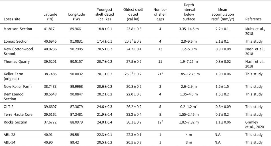
a Error for accumulation rates is based on the 2-sigma calibrated radiocarbon age error.
b Mean of lower two ages (used midpoint depth).
c Not all ages are shown on stratigraphic columns (Fig. 3) for readability.
d Measured below Tiskilwa Formation.
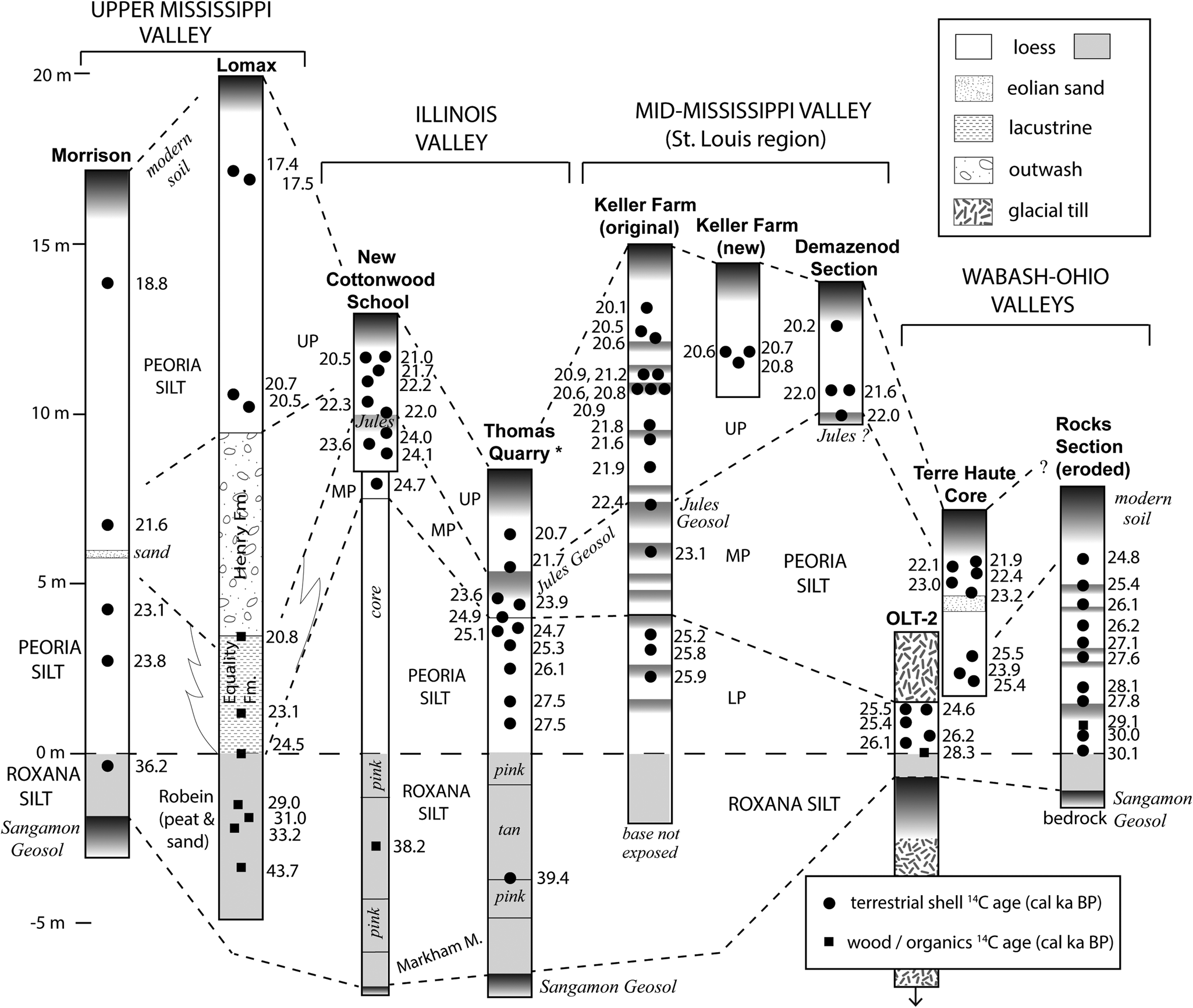
Figure 3. Stratigraphic columns and correlations of loess sites, normalized (at zero line) to basal contact of Peoria Silt (white) with underlying Roxana Silt (solid gray). The modern soil, last interglacial soil (Sangamon Geosol), and minor paleosols within Peoria Silt are shown with darker gradient shading. Calibrated radiocarbon ages from terrestrial gastropod shells are shown (black circles), along with other organic ages (squares). All sites are outcrops, except for Terre Haute Core and New Cottonwood School Section (combined upper section with core into lower Peoria and Roxana Silt). LP, lower Peoria Silt; MP, middle Peoria Silt; UP, upper Peoria Silt.
For comparative purposes, terrestrial shells and organic samples (including leaves, needles, and wood) were both collected from palustrine deposits at Clayton, Plainfield, and Ward Quarry Sections in central Indiana. The ages were not used for loess chronology, but only for examining any differences in the age of fossil shells and organics collected from the same geologic layer.
Finally, four historically collected Succineidae shells (Novisuccinea ovalis) from the Illinois Natural History Survey Mollusk Collection (Prairie Research Institute, University of Illinois) were dated. Two shells from McHenry County, Illinois, had been collected ca.1900 CE and two shells from St. Clair County, Illinois, had been collected in 1937 CE. The shell surfaces were covered by periostracum coatings, suggesting they not reworked from older sediments.
Gastropod shell sorting and identification
Field-collected bulk loess samples were soaked in water to disaggregate and then washed through a 0.5 mm sieve to collect gastropod shells. Shells were then sorted according to taxa. Identifications of terrestrial gastropods were based on literature or comparisons with the Byron Leonard Pleistocene mollusk collection or the F.C. Baker Cenozoic mollusk collection, both housed at the Prairie Research Institute (University of Illinois at Urbana-Champaign). Highly fragmented shells were not identified or used for radiocarbon dating. Other resources used for identification included Burch and Jung (Reference Burch and Jung1988), Leonard and Frye (Reference Leonard and Frye1960), Pilsbry (Reference Pilsbry1939), Baker (Reference Baker1939), and the Carnegie Museum of Natural History website (https://www.carnegiemnh.org/science/mollusks/index.html).
Gastropod shell cleaning and radiocarbon dating
Identifiable terrestrial gastropod shells of particular species, suitable for radiocarbon dating, were selected for radiocarbon dating. Individual shells were chosen with limited alteration. Before being submitted for dating, gastropod shells were cleaned by sonication for 30 to 60 seconds. Shells were then broken and lightly etched with dilute hydrochloric acid while being examined microscopically to ensure partial dissolution. Shells were treated to remove any adhering secondary carbonate (that could cause a too young age) and also to remove any adhering primary mineral grains (that could cause a too old age from silt-size Paleozoic dolomite grains in the loess). Shells were again sonicated, if needed. Finally, the shells were washed with water on a sieve and reexamined microscopically to be sure the shells were visibly clean, particularly in the apex area. If necessary, the process was repeated. Cleaned shell fragments were submitted to either the National Ocean Sciences Accelerator Mass Spectrometry Facility (Woods Hole Oceanographic Institution), the Center for Accelerator Mass Spectrometry (Lawrence Livermore National Laboratory), or the W. M. Keck Carbon Cycle Accelerator Mass Spectrometer Facility (University of California, Irvine). The AMS radiocarbon age determinations and 2-sigma errors were calibrated with Calib 8.2 using IntCal20 (Stuiver and Reimer; Reference Stuiver and Reimer1993; Reimer et al. Reference Reimer, Austin, Bard, Bayliss, Blackwell, Bronk Ramsey and Butzin2020). Prior radiocarbon age determinations from the literature were also recalibrated with IntCal20 (Calib 8.2) for use in a stratigraphic figure and discussion. The median calibrated age was used for individual depth at loess section, and mean pooled ages (calculated using Calib 8.2) were used at sites with multiple ages for a sample interval.
Loess Accumulation Rates
Mean accumulation rates (thickness/age) were calculated using the oldest and youngest calibrated shell radiocarbon ages and the stratigraphic thickness between these ages (Table 1). Succineidae ages were used in most cases, as they are known to provide accurate radiocarbon ages (Pigati et al,. 2010; this study). At sites where multiple shell ages from different taxa were determined at the same depth (such as Keller Farm Section), only Succineidae ages were used. Where two or more Succinea shells occur at the same depth, their ages were averaged. The 2-sigma errors for calibrated ages were propagated into the accumulation rates by the following method: (1) the percent error on time duration between oldest and youngest shell ages was calculated from (mean of 2-sigma errors)/(duration); (2) this percentage was multiplied by the accumulation rate, and rounded, to determine the accumulation rate 2-sigma error.
RESULTS
New chronological data from terrestrial gastropod shells at several loess sections are here combined with shell 14C data from previously published sections (Fig. 3; Tables 1 and 2). Data from prior studies include Cottonwood School and Thomas Quarry Sections (Nash et al., Reference Nash, Conroy, Grimley, Guenthner and Curry2018), Rocks Section (Grimley et al., Reference Grimley, Counts, Conroy, Wang, Dendy and Nield2020), and Morrison Section (Pigati et al., Reference Pigati, McGeehin, Muhs, Grimley and Nekola2015; Muhs et al., Reference Muhs, Bettis and Skipp2018). Summarized here are results from sites newly dated for this study (Lomax Section, Keller Farm Sections, Demazenod Section, Terre Haute Core, OLT-2, ABL-28, ABL-54). Radiocarbon results of historical (early twentieth century, Illinois) Succineidae shells and last glacial shell–organic age comparisons (Indiana) are also reported.
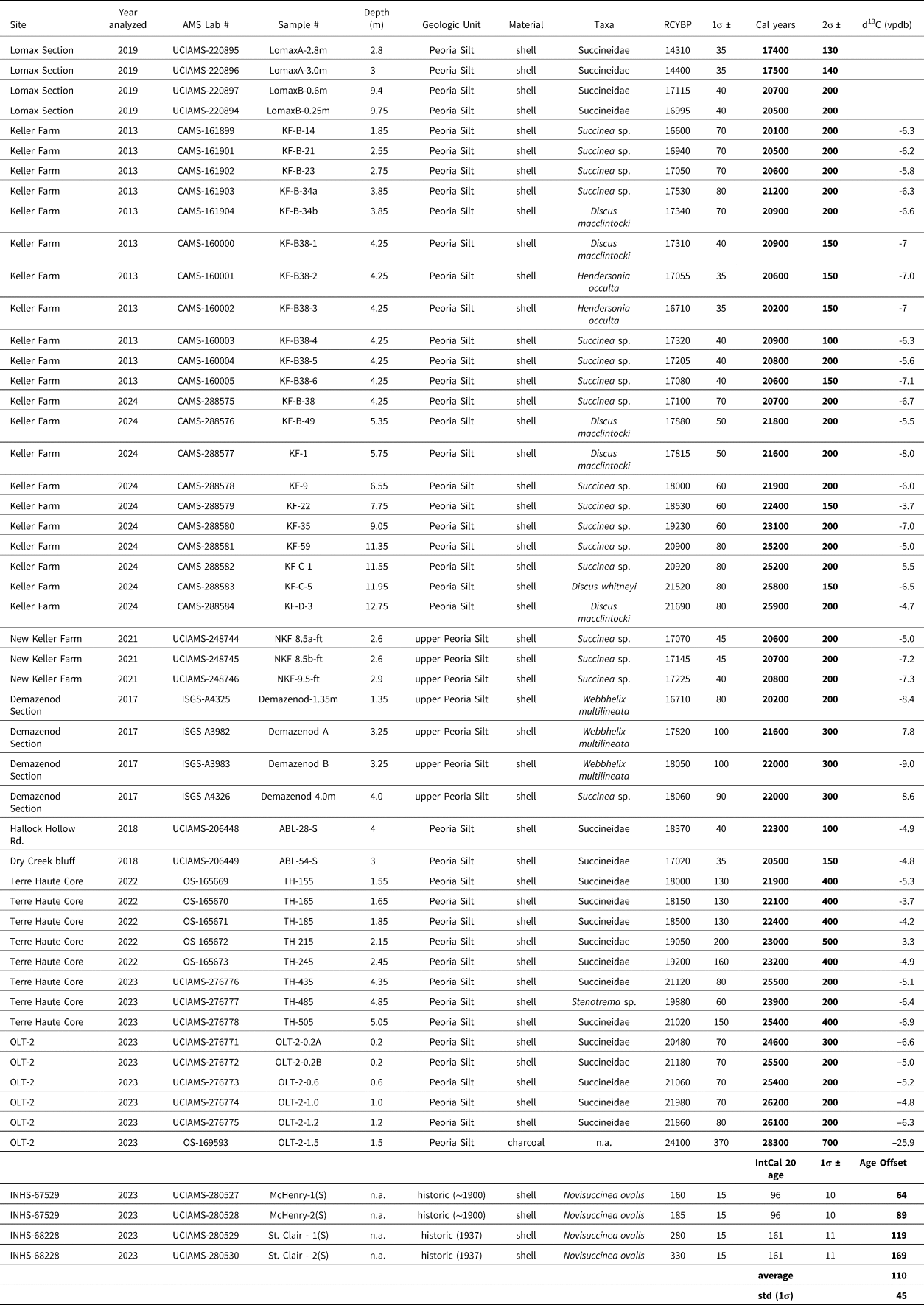
Table 2. Summary of new radiocarbon ages on terrestrial gastropod shells (and one charcoal age). Ages were calibrated with Calib 8.2 using IntCal20 (Stuiver and Reimer, Reference Stuiver and Reimer1993; Reimer et al., Reference Reimer, Austin, Bard, Bayliss, Blackwell, Bronk Ramsey and Butzin2020; Stuiver et al., Reference Stuiver, Reimer and Reimer2023) and rounded to nearest 100 years. Shell samples leached 50% with dilute HCl before hydrolysis with 85% phosphoric acid. Succineidae shells from the Haddock Hollow Road and Dry Creek Bluff were from the A. Byron Leonard collection housed at the Prairie Research Institute (University of Illinois). For accelerator mass spectrometry (AMS) lab numbers: OS, Woods Hole Oceanographic Institution; CAMS, Lawrence Livermore National Lab; UCIAMS, University of California Irvine. For the four historically collected shells, the age offset was calculated between the uncalibrated shell radiocarbon ages and the IntCal20 dataset that considers atmospheric variations in 14C.
Lomax Section
Data from Lomax Section, shown in Figure 3, include both new shell ages from loess and prior age determinations on organics from glacial lake sediment and peat below the Peoria Silt (Curry, Reference Curry1998). Four new radiocarbon ages were determined on Succineidae shells (Fig. 2) from upper and lower parts of the Peoria Silt to constrain its age of deposition (Fig. 4). The modern soil solum is developed into the upper meter of loess (of 11.5 m total), with carbonates leached to 1.5 m and well-preserved gastropod shells occurring in zones below 2.5 m (Fig. 4). The loess is a silt to silt loam, friable, and generally oxidized. Munsell colors ranged from 10YR 5/4 (yellowish brown) at 1–3 m depth to 2.5Y 5/4 (light olive brown) in loess below 3m.
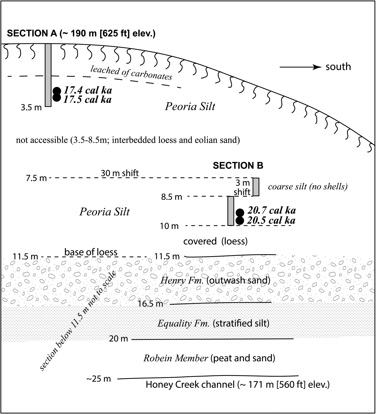
Figure 4. Lomax Section stratigraphy and field context of Succineidae shell ages. This site, in western Illinois on the eastern bluff of the Mississippi Valley, was studied by Dendy (Reference Dendy2023) and Curry (Reference Curry1998). A field description is provided in Supplementary Table S1.
Succineidae shells from the uppermost Peoria Silt, at 2.8–3.0 m depth, yielded calibrated ages of 17.4 ± 0.1 and 17.5 ± 0.1 ka. Shells collected from the basal Peoria Silt, above Henry Formation outwash, provided ages of 20.5 ± 0.2 (9.75 m) and 20.7 ± 0.2 ka (9.4 m). Averaging the lower two ages, this implies that 6.8 m of Peoria loess, with some interbedded eolian sand, was deposited in 3.2 ± 0.2 ka. An average loess accumulation rate of 2.1 ± 0.1 mm/yr is unusually high for Illinois (twice the rate of Nash et al. [Reference Nash, Conroy, Grimley, Guenthner and Curry2018]), but this rate likely results in part from the site containing beds of eolian fine sand. The upper 2.7 m of non-fossiliferous loess may account for an additional 2 ka of sedimentation time, assuming a slightly reduced loess accumulation rate before modern soil development.
Keller Farm Sections (original and new)
Radiocarbon ages on terrestrial gastropod shells from upper Peoria Silt at the original Keller Farm Section ranged from 20.1 ± 0.2 to 25.9 ± 0.2 ka at depths of 1.85 to 12.75 m below ground surface. Twent-one shell ages from three genera (Succinea, Discus, Hendersonia) sampled from multiple depths in this interval provide a strong case for the loess chronology below the modern soil. Because Hendersonia is not a highly recommended genera for radiocarbon dating (Pigati et al., Reference Pigati, Rech and Nekola2010), only the Succinea and Discus shell ages are shown in Figure 3 and are used for accumulation rate calculations. A mean loess accumulation rate of 1.9 ± 0.06 mm/yr during this time period is estimated, using the 25.9 ka age at 12.75 m. The shell ages reported here are 1.4 ka older (at 4.25 m depth) to 6.2 ka older (at 1.85 m depth) than calibrated ages from the Wang et al. (Reference Wang, Follmer and Liu2000) age model, based on volatile organic matter radiocarbon dating from the same section. The shell ages increasingly diverge from the Wang et al. (Reference Wang, Follmer and Liu2000) age model near the surface, suggesting potential contamination of the disseminated organic matter ages with modern organic carbon. However, below 5 m the new shell calibrated ages are within 1 ka of calibrated organic matter ages from Wang et al. (Reference Wang, Follmer and Liu2000). The shell ages suggest the Jules Geosol (which separates the upper and middle Peoria Silt), occurs at about 8 m depth (Fig. 3).
Three Succinea sp. shell ages were also determined from upper Peoria Silt at a more recent exposure (called the New Keller Farm Section) about 500 m east of the original Keller Farm site. The New Keller Farm Section provided ages of 20.6 ± 0.2, 20.7 ± 0.2, and 20.8 ± 0.2 ka at depths of 2.6 to 2.9 m; these ages are consistent with the shell ages from the original Keller Farm section at similar depths (Fig. 3).
Demazenod Section
Field-visible gastropod shells were sampled from 1.35 to 4.0 m within Peoria Silt at this section, below the leached modern soil solum (0–1.2 m). Terrestrial shells of Succinea sp., Webbhelix multilineata, Allogona profunda, and Stenotrema hirsutum were sampled from the outcrop. The W. multilineata were up to 20 mm in diameter. Other smaller shells present included Carychium exile, Euconulus fulvus, Haplotrema concavum, Hendersonia occulta, Nesovitrea electrina, Punctum minutissimum, Vertigo hubrichti, Vertigo modesta, and Zonitoides arboreus. The uppermost fossil shell sampled at 1.35 m (Webbhelix) yielded a calibrated radiocarbon age of 20.2 ± 0.2 ka, whereas the lowermost shell dated at this exposure, at 4.0 m depth, yielded an age of 22.0 ± 0.3 ka. A concentration of large shells was found at ~3.25 m depth; two Webbhelix (Fig. 2) were dated at 21.6 ± 0.3 and 22.0 ± 0.3 ka. This site only exposes the upper Peoria Silt (terminology of Grimley et al. [1998]), with about two-thirds of the Peoria loess not exposed at the excavation. From 3.7–4.25 m, the loess was more mottled and had iron stains, abundant secondary carbonate, and few gastropod shells. These characteristics imply a slower deposition rate for this zone, with more weathering and leaching of carbonate. It is suspected, but not certain, that this zone may correlate to the upper Jules Geosol zone at Cottonwood School and Thomas Quarry (Nash et al., Reference Nash, Conroy, Grimley, Guenthner and Curry2018). The mean loess accumulation rate from 1.35 to 4 m depth is 1.5 ± 0.2 mm/yr.
Terre Haute Core and OLT-2
For the Terre Haute Core (western Indiana), radiocarbon ages on seven Succineidae shells and one Stenotrema sp. shell range from 21.9 to 25.5 ka. Five shell ages, collected between 1.55 and 2.45 m depth, range from 21.9 to 23.2 ka. These ages all occur in stratigraphic order and indicate a mean loess accumulation rate of 0.7 ± 0.2 mm/yr for this depth range. This rate is slower than the ~1 mm/yr found in thick fossiliferous loess along the Illinois River valley (Thomas Quarry, New Cottonwood School), but faster than the Jules Geosol zone rate of 0.5 mm/yr (Nash et al., Reference Nash, Conroy, Grimley, Guenthner and Curry2018). Three additional ages were determined at depths of 4.35–5.05 m. The 25.5 ka shell age from 4.35 m is out of stratigraphic order, but the other two are consistent with the upper five shell ages. The lower ages were not included in the loess accumulation rate calculation because of this inconsistency and also the presence of an eolian sand bed.
The OLT-2 Section is located 16 km north of the Terre Haute Core and just under 2 km north of the last glacial ice margin. The lower part of the Peoria loess (Morton Tongue) is fossiliferous and preserved below glacial till (Tiskilwa Formation). For the OLT-2 Section, five Succineidae shell ages from the Peoria Silt range from 24.6 to 26.2 ka in loess that is 0.2–1.2 m below the till. Using the shell ages, we estimate a mean loess accumulation rate of 0.6 ± 0.09 mm/yr, similar to the rate in the Terre Haute Core. At 1.5 m below the till, and near the basal Peoria Silt contact (with Roxana Silt below), charcoal was dated at 28.3 ka.
Sites ABL-28 and ABL-54
Succineidae shells at both ABL sites, from archived collections of A. Byron Leonard, were collected in a basal zone of calcareous loess above a last glacial till unit (also calcareous). Ages of 22.5 ka and 20.5 ka resulted from shells at ABL-28 and ABL-54, respectively. The 22.5 ka age overlies Tiskilwa Formation till and the 20.5 ka age overlies till of either the Batestown Member (Lemont Formation) or the Tiskilwa Formation. The exact depth of dated shells in the loess is not known, although field notes state that gastropods are from the basal loess (and uppermost loess would be leached of carbonates). Based on a lack of alteration below the loess–till contact, both till and loess were deposited during the LGM (full glacial Wisconsin Episode). Thus, the ages provide a minimum estimate of the till age. However, the tills are likely slightly older (23 to 24 ka) based on the regional stratigraphy and geochronology (Curry et al., Reference Curry, Lowell, Wang, Anderson, Kehew and Curry2018).
Historical (early twentieth century) Succineidae
The four shells were analyzed from the Illinois Natural History Survey historical collections (early twentieth century), previously identified as Novisuccinea ovalis and ranging in length from 13 to 17 mm. These shells yielded radiocarbon ages between 160 ± 15 and 330 ± 15 14C yr BP (reported as years before 1950). Two gastropod shells were collected ca. 1900 (McHenry County site) and two in 1937 (St. Clair County site), according to Illinois Natural History Survey records. The age of the shells should be 96 and 161 yr, respectively, for each site, based on the IntCal20 data set that considers atmospheric variations in 14C. Thus, the radiocarbon ages are about 60–90 yr too old at the McHenry site and about 120–170 yr too old at the St. Clair site. Considering all four ages, a radiocarbon age offset of ~110 ± 45 14C yr (before calibration) is indicated for Succineidae.
Fossil gastropod–organic age comparisons
As a further test of the validity of using terrestrial gastropod radiocarbon ages for loess chronology, a comparison of co-occurring shells and organics (wood, needles, leaves) was made at three sites with well-preserved fossiliferous silts in central Indiana. The shells used were predominantly Succineidae, but included one Discus and one Gastrocopta. From this comparison (Fig. 5, Supplementary Tables S2 and S3) the mean pooled ages of the terrestrial shells are similar to organics at Clayton Section, ~300 yr older than organics at Ward Quarry, and ~500 yr older than organics at Plainfield Section. Taking all three sites into consideration, the shell ages are about 250 yr too old on average, slightly more than dating of historical Succineidae shells. The offset is probably partially a result of modest uptake of old carbon from Paleozoic dolomite mineral grains, a common constituent of unaltered loess in the Central Lowlands. Other possible factors include burrowing of snails or slight differences in the stratigraphic zone where shells and wood occur within the sample.
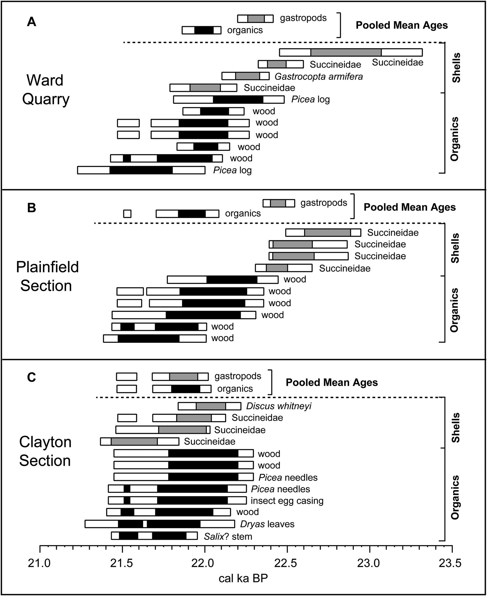
Figure 5. Comparison of individual and pooled mean calibrated radiocarbon ages for last glacial terrestrial gastropod shells (mainly Succineidae) and organics from Ward Quarry (A), Plainfield Section (B), and Clayton Section (C) in central Indiana (Fig. 1). The black bars (organics) and gray bars (shells) represent 1-sigma 14C age ranges, and the white bars represent 2-sigma 14C age ranges. The pooled mean ages (calibrated) for shells and organics are similar at the Clayton Section, ~300 yr older at Ward Quarry, and ~500 yr older at the Plainfield Section. The organics are mainly wood with some needles and leaves (Supplementary Table S2). These fossils were found in last glacial palustrine sediment between the Center Grove Member till and Cartersburg Member till of the Trafalgar Formation (Wayne, Reference Wayne1963; Loope et al., Reference Loope, Antinao, Monaghan, Autio, Curry, Grimley, Huot, Lowell, Nash and Florea2018).
DISCUSSION
Small terrestrial gastropod shells in last glacial loess are found to provide reliable and reasonable radiocarbon chronologies. A combination of new shell radiocarbon ages and compilations of prior ages, acquired over the past decade, reveals a more detailed chronology for the last glacial Peoria Silt (loess) in Illinois and western Indiana. The resulting Peoria Silt shell ages, ranging from ~30 to 17 ka (for fossiliferous portions), are consistent with current knowledge of regional glacial history and the advance of glacial lobes of the southern Laurentide Ice Sheet (Dalton et al., Reference Dalton, Margold, Stokes, Tarasov, Dyke, Adams and Allard2020; Fig. 6), as well as an influx of Central Lowlands glacial sediment to the Gulf of Mexico (Kohl et al., Reference Kohl, Curry and Miller2021). This age range is also similar to studies of Pigati et al. (Reference Pigati, McGeehin, Muhs, Grimley and Nekola2015) for Peoria loess along the lower Mississippi Valley (30–22 cal ka) and to studies of thick Peoria loess along the Missouri River valley in western Iowa (29–17 ka; Muhs et al., Reference Muhs, Bettis, Roberts, Harlan, Paces and Reynolds2013; Pigati et al., Reference Pigati, McGeehin, Muhs and Bettis2013), based on both luminescence and calibrated radiocarbon ages. The shell ages from the upper Peoria Silt at the Keller Farm Section in southwestern Illinois, however, are older than reported ages on volatile organic matter from the same section (Wang et al., Reference Wang, Follmer and Liu2000, Reference Wang, Hughes, Steele, Lepley and Tian2003). We suspect that the volatile organic matter radiocarbon ages in the upper 5 m are minimum ages, affected by soil processes and organic additions within a few meters of the ground surface and that the shell ages are more reflective of the loess accumulation age.
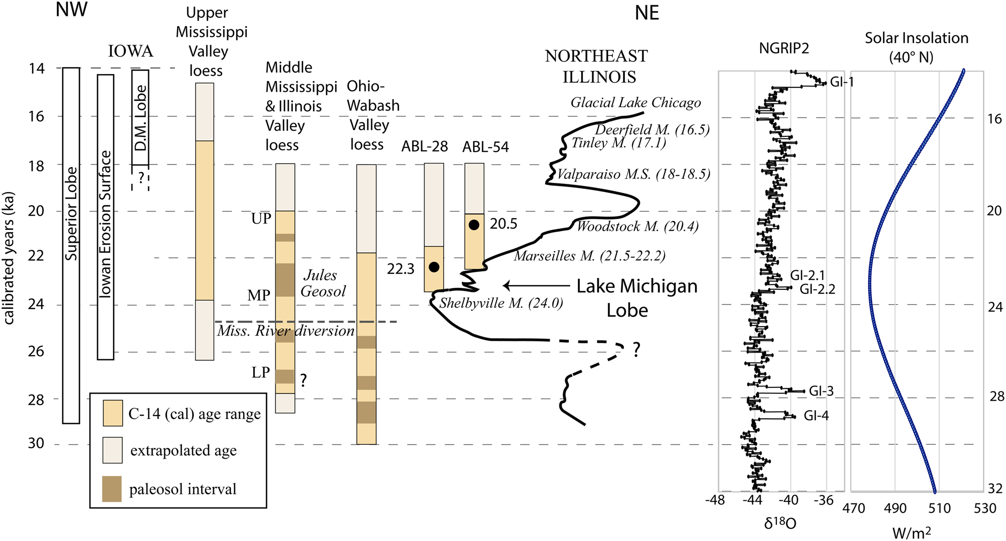
Figure 6. Regional perspective of loess chronology in the Central Lowlands (three representative columns for regional loess stratigraphy based on multiple study sites), with comparison to the Lake Michigan Lobe, Superior Lobe, Iowan Erosion Surface (when active), and changes in solar insolation. The time–distance diagram of Lake Michigan Lobe, with northeastern Illinois moraine ages (cal ka BP), is modified from Curry et al. (Reference Curry, Lowell, Wang, Anderson, Kehew and Curry2018). Timing of Iowan Erosion Surface is based on Bettis et al. (Reference Bettis, Muhs, Roberts and Wintle2003) and Mason (Reference Mason2015). Timing of Des Moines Lobe (D.M. Lobe) is based on Muhs et al. (Reference Muhs, Bettis, Roberts, Harlan, Paces and Reynolds2013), Heath et al. (Reference Heath, Loope, Curry and Lowell2018), and Dalton et al. (Reference Dalton, Margold, Stokes, Tarasov, Dyke, Adams and Allard2020). Timing of the Superior Lobe is from Johnson and Mooers (Reference Johnson and Mooers1998) and Dalton et al. (Reference Dalton, Margold, Stokes, Tarasov, Dyke, Adams and Allard2020). The NGRIP2 North Greenland ice core data (δ18O) and Greenland Interstadial (GI) intervals are from Rasmussen et al. (Reference Rasmussen, Bigler, Blockley, Blunier, Buchardt, Clausen and Cvijanovic2014). The solar insolation curve for 40°N latitude is from Laskar et al. (Reference Laskar, Robutel, Joutel, Gastineau, Correia and Levrard2004). The timing of the Mississippi River diversion, resulting in source area shifts at about 24.4 cal ka BP, separates the lower and middle Peoria Silt along the Illinois River valley.
Given that fossil gastropods are not preserved in the leached modern soil (to depths of 1–2 m) in studied loess sections that contain ~6- to 17-m-thick Peoria Silt, it is not possible to date the upper 10–25% of Peoria Silt. A slower sedimentation rate is suspected with more distal loess sources during deglaciation. An interstadial soil within the Peoria Silt was previously found to have a 50% reduced sedimentation rate, compared with fossiliferous loess (Nash et al., Reference Nash, Conroy, Grimley, Guenthner and Curry2018). We thus extrapolate (estimate) the youngest age for Peoria Silt into the modern soil (Fig. 6) assuming the accumulation rate is about half the rate of fossiliferous loess accumulation rate (Supplementary Table S4). Ages for the basal Peoria Silt contact, with Roxana Silt below, are also projected for some areas. The full range for Peoria loess accumulation is thus interpreted to be ~27–15 ka for loess along the upper Mississippi Valley in northwestern Illinois (Morrison and Lomax Sections), 29–18 ka for loess along the Illinois and middle Mississippi Valleys (Keller Farm, Demazenod, Thomas Quarry, Cottonwood School Sections), and 30–18 ka for loess along the Ohio and Wabash River valleys (Rocks Section, Terre Haute Core, and OLT-2) (Fig. 6).
Reliability of terrestrial gastropod radiocarbon ages
Prior work has also shown the consistency and usefulness of terrestrial shell ages (Pigati et al., Reference Pigati, Rech and Nekola2010, Reference Pigati, McGeehin, Muhs and Bettis2013; Újvári et al., Reference Újvári, Molnár, Novothny, Páll-Gergely, Kovács and Várhegyi2014; Grimley et al., Reference Grimley, Counts, Conroy, Wang, Dendy and Nield2020; Gu et al., Reference Gu, Lu, Hajdas, Haghipour, Zhang, Wu and Shao2023), as long as problematic large genera such as Mesodon (Rakovan et al., Reference Rakovan, Rech, Pigati, Nekola and Wiles2010; Pigati et al., Reference Pigati, McGeehin, Muhs, Grimley and Nekola2015) and Rabdotus (Forman et al., Reference Forman, Hockaday, Liang and Ramsey2021) are avoided. In the current study, we have found that Succineidae, Discus, Webbhelix, and Stenotrema provide consistent and reliable radiocarbon ages that are mainly in stratigraphic order. As an additional test, Succineidae were dated alongside wood, needles, or leaves from three sites from last glacial palustrine sediments (loess derived) in central Indiana. Based on comparisons of 12 shell ages and 21 organic ages, the shells average ~250 calibrated years older, with an offset ranging from 0 to 500 yr. It is not clear if this difference is due solely to old carbon effects or if there were complications from snail burrowing or slight variations in sample depths. The offsets are in the range of the 2-sigma errors for calibrated shells at the other loess sites studied (Fig. 3, Table 2).
Age dating of four individual shells of Novisuccinea ovalis from Illinois Natural History Survey archived historical collections has also shown age offsets of 60 to 170 yr compared with known sampling in the early twentieth century (Table 2). The mean offset from these four shell ages is about 110 ± 50 yr, from a modest amount of old carbon input, consistent or less than the shell-organic age offsets noted earlier in the fossil record. Thus, an age correction for Succineidae shells is probably not warranted.
Spatial variations in loess chronology, loess cessation, and accumulation rates
A clear finding from this compilation of 32 new gastropod shell ages and 36 previously published shell ages, is that the cessation of Peoria Silt deposition varies by region or by major valley loess source in the Central Lowlands (Figs. 1, 3, and 6, Table 2, and Supplementary Table 5). The uppermost shell age within the Peoria Silt is 21.9 ± 0.4 ka in Wabash Valley loess (Terre Haute Core), 20.5–20.7 ± 0.3 ka in Illinois Valley loess (Thomas Quarry, Cottonwood School), 20.1–20.2 ± 0.2 ka in middle Mississippi Valley loess (Keller Farm, Demazenod Section), and 17.4–18.8 ± 0.1 ka in upper Mississippi Valley loess (Morrison and Lomax Sections).
Mean accumulation rates at proximal loess sites at a similar distance from major valleys also differ significantly geographically (by valley segment). Mean accumulation rates for fossiliferous portions of loess sections range between 0.6 ± 0.1 mm/yr (OLT-2 Section) and 2.2 ± 0.1 mm/yr (Morrison Section). The loess includes weak interstadial paleosols at some sites, so that loess zones with preserved terrestrial gastropods generally had mean accumulation rates >1 mm/yr. Extrapolations of mean accumulation rates into the modern soil (at 50% rate of fossiliferous loess) result in loess cessation times of ~18 ka for the Wabash, Illinois, and mid-Mississippi Valleys, and ~15 ka for the upper Mississippi Valley region (Supplementary Table S4). Accumulation rates of 100%, 70%, and 30% of the fossiliferous loess rate within the modern soils were also calculated (Supplementary Table S4) and show that time of loess cessation could be up to 1–2 ka older or 1–3 ka younger, but the differences between geographic areas are relatively consistent. An earlier time for loess cessation in southern and eastern areas may be due to either sediment supply factors, valley conditions, or climatic conditions.
Factors controlling loess accumulation
Loess deposition requires at least four conditions: (1) a consistent supply of fine-grained sediment; (2) a period of drying (and lack of snow cover, frozen conditions, or dense vegetation), such that silty sediment can be deflated from exposed valley trains; (3) strong winds that can cause deflation and dust storms; and (4) vegetated uplands that can anchor the newly deposited dust. These four factors, in the context of the study area, are discussed in the following subsections, with sediment supply addressed in the first subsection and the three climate–vegetation factors combined in the second subsection.
Glacial and periglacial sediment supply
Young loess deposits in the upper Mississippi Valley region compared with the Illinois Valley region can in part be explained by sediment supply, with the Superior Lobe and Des Moines Lobe providing significant sediment up to 16 ka and perhaps as late as 14 ka (Dalton et al., Reference Dalton, Margold, Stokes, Tarasov, Dyke, Adams and Allard2020). The Iowan Erosion Surface, an area of periglacial erosion, was also a likely contributor of sediment from about 23 ka or earlier, until as late as 14 ka (Loope et al., Reference Loope, Mason, Goble, Hanson and Young2013; Mason, Reference Mason2015). These sediment sources are consistent with loess cessation at ~15 ka from our extrapolations in the upper Mississippi Valley region (Fig. 6). In contrast, the Lake Michigan Lobe had retreated into the Lake Michigan Basin watershed by around 17.5 ka (Curry et al., Reference Curry, Lowell, Wang, Anderson, Kehew and Curry2018; Dalton et al., Reference Dalton, Margold, Stokes, Tarasov, Dyke, Adams and Allard2020; Fig. 6). The Green Bay Lobe would also have contributed sediment to the Mississippi River valley (including its ancestral path before its 24.5 ka diversion) via the Wisconsin River valley and Rock River valley from ~30 to 18 ka (Heath et al, Reference Heath, Loope, Curry and Lowell2018; Carson et al., Reference Carson, Attig, Rawling, Hanson and Dodge2020). After the Tinley Moraine was formed, meltwater from the Lake Michigan Lobe would have been largely trapped in glacial Lake Chicago and would not have provided a source for loess in the Illinois Valley region. Thus, our extrapolated age estimate of ~18 ka for the cessation of Peoria Silt deposition (excluding distal loess of minimal thickness) is consistent with the Lake Michigan Lobe history. Our revised age estimates for loess deposition along the Illinois and Mississippi Valleys are remarkably similar to the early age estimates of Frye et al. (Reference Frye, Glass and Willman1968) based on a limited number of conventional 14C ages. With regard to the Wabash Valley region loess, the Lake Michigan Lobe sediment would have been cut off by about 20.5 ka as discharge rerouted to the Kankakee and Illinois Valleys during ice recession (Curry et al., Reference Curry, Lowell, Wang, Anderson, Kehew and Curry2018; Dalton et al., Reference Dalton, Margold, Stokes, Tarasov, Dyke, Adams and Allard2020). However, the Huron-Erie Lobe probably continued to provide meltwater sediment until at least 19 to 18.5 ka (Dalton et al., Reference Dalton, Margold, Stokes, Tarasov, Dyke, Adams and Allard2020), with sediment trapped in moraine-dammed proglacial lakes after about 17.5 ka (Fisher et al., Reference Fisher, Blockland, Anderson, Krantz, Stierman and Goble2015). Thus, the glacial history of the southern Laurentide Ice Sheet can partly explain the ~18 ka shutdown of loess in the Wabash-Ohio Valleys loess region.
From loess-influenced lake sediment records in the Illinois Valley region, Curry et al. (Reference Curry, Puleo, Pentrak, Diefendorf, Lowell and Sivapalan2022) and Curry (Reference Curry2024) interpreted 17.9 ± 0.4 ka as the end of proximal loess deposition and 15.6 ± 0.3 ka for the end of distal loess deposition. The cessation of proximal loess at this site, based on a change from illite-rich to smectite-rich loess (Curry et al., Reference Curry, Puleo, Pentrak, Diefendorf, Lowell and Sivapalan2022), is also coincident with retreat of the Lake Michigan Lobe ice margin and a slowing of loess accumulation. The youngest 2 ka period of loess deposition is likely distal (fine-grained) loess or dust from the Mississippi Valley (or areas westward), related to glacial activity in the Superior Lobe or Northern Plains. Minor amounts of distal loess during the late glacial and Holocene, following the cessation of proximal loess deposition, has previously been suggested to varying degrees (Mason and Jacobs, Reference Mason and Jacobs1998; Miao et al., Reference Miao, Hanson, Stohr and Wang2018; Grimley et al., Reference Grimley, Curry, Nash and Huot2019). Although Holocene loess is present in the Great Plains region (Bettis et al., Reference Bettis, Muhs, Roberts and Wintle2003; Mason et al., Reference Mason, Jacobs, Hanson, Miao and Goble2003), the loess record in the glaciated Central Lowlands implies that atmospheric deposition of silty deposits during the Holocene was much reduced (Grimley et al., Reference Grimley, Curry, Nash and Huot2019) after the major glacial lobes of the southern Laurentide Ice Sheet receded and land surfaces became overall more stable, more humid, more vegetated, and less windy.
Climatic factors, valley hydrology, and vegetation
Climatic factors, such as wind, precipitation, temperature, and humidity may have also influenced the initiation, cessation, and rate of Peoria Silt deposition by affecting valley hydrological conditions and vegetation in both the loess source areas (major valleys) and loess accumulation areas (adjacent uplands). Seasonally lower wind speeds and valleys filled with meltwater discharge would likely have precluded the summer season as the dominant time of loess deposition in proglacial regions (Crusius et al., Reference Crusius, Schroth, Gassó, Moy, Levy and Gatica2011; Conroy et al., Reference Conroy, Karamperidou, Grimley and Guenthner2019). Climate conditions in the spring and fall more likely controlled whether sediments in broad valleys were exposed and dried during windows of time between the summer glacial melt season and winter freeze-up. Winter dustiness is typically inhibited due to snow cover and/or frozen soil (Crusius et al., Reference Crusius, Schroth, Gassó, Moy, Levy and Gatica2011; Bullard and Mockford, Reference Bullard and Mockford2018). Intensified mean seasonal and maximum daily winter, fall, and spring westerly winds occurred during the LGM relative to preindustrial conditions (Conroy et al., Reference Conroy, Karamperidou, Grimley and Guenthner2019). As the ice sheet receded, wind speeds may have diminished due to reduced temperature and pressure gradients between the previously glaciated and ice-free region to the south, impeding loess deposition in areas farther from the ice margin, as well as a reduction in glacial katabatic winds near the ice margin. This factor could also explain why loess deposition halted in the St. Louis region (Keller Farm, Demazenod Sections) before it halted in the more northerly upper Mississippi Valley region.
Fall and spring windows of dustiness and loess deposition may have shortened or closed if conditions became warmer earlier in spring or longer into fall or if higher rates of spring and fall rainfall led to higher streamflow, moist soil conditions, denser vegetation in valleys, and limited fluvial sediment exposure to the atmosphere. Presumably more humid areas to the east and south, closer to moisture sources from the Atlantic and Gulf Coasts, were more sensitive to valley drying being a limiting factor for ideal loess conditions. Hayward and Lowell (Reference Hayward and Lowell1993) and Nickling (Reference Nickling1978) both highlight the importance of low soil moisture in favoring silt deflation from valleys and loess accumulation. We speculate that as the southern Laurentide Ice Sheet margin receded northward during the deglaciation, increasing temperature and humidity likely encroached northward from the Gulf of Mexico (Voelker et al., Reference Voelker, Stambaugh, Guyette, Feng, Grimley, Leavitt and Panyushkina2015; Lora and Ibarra, Reference Lora and Ibarra2019). Higher temperatures and humidity (and vegetation changes) would likely have first impacted loess sedimentation in the lower and middle Mississippi, Wabash, and Ohio Valleys before impacting the upper Mississippi Valley. This could also explain the earlier age of loess cessation, thinner loess, and slower accumulation rates in the more southern and eastern areas of the midcontinent.
Paleovegetation data and the presence of terrestrial gastropods suggest that uplands in the study area were predominantly covered by boreal vegetation during the LGM (Leonard and Frye, Reference Leonard and Frye1960; Baker et al., Reference Baker, Sullivan, Hallberg and Horton1989; Liu et al., Reference Liu, Andersen, Williams and Jackson2013; Jones et al., Reference Jones, Williams and Jackson2017). Thus, vegetation was likely not a significant limiting factor in capturing eolian silt on the landscape in most of Illinois and Indiana, but sparse vegetation was locally a factor in tundra and periglacial regions of northeast Iowa, southeast Minnesota, and southwest Wisconsin (Mason, Reference Mason2015). From a climatic standpoint, Jones et al. (Reference Jones, Williams and Jackson2017) noted an increase in Quercus pollen at ~17.5 ka at Cupola Pond in the Missouri Ozarks, suggesting an increase in temperature and perhaps effective moisture at this time in the midcontinent. However Picea and Pinus, typical of peak glacial climate records in southern Illinois and Missouri, decline significantly later, after 14.5 cal ka (Jones et al., Reference Jones, Williams and Jackson2017). Similar transitions from conifer-dominant to deciduous-dominant vegetation occur in central Kentucky, but between 18.7 and 15.4 ka (Liu et al., Reference Liu, Andersen, Williams and Jackson2013). In northeastern Illinois, a transition to dominantly deciduous pollen did not occur until ~14.5 ka (Curry et al., Reference Curry, Grimm, Slate, Hansen and Konen2007; Gonzales and Grimm, Reference Gonzales and Grimm2009). Thus, last glacial vegetation records support time-transgressive increases in humidity and temperature from south to north, which may have been significant controlling factors in loess accumulation through effects on deflation of fine-grained sediment from meltwater valleys. Other spatially limited precipitation proxy records and a transient model simulation suggest drying during the deglacial period in the southeast and north-central United States (Lora and Ibarra, Reference Lora and Ibarra2019). Thus, more precipitation proxy records and data-model analysis focusing on seasonality are clearly needed to resolve the time-transgressive nature of deglacial precipitation in areas of North American loess deposition.
Intra-loess paleosols
Weak, incipient paleosols have been observed within the Peoria Silt at several locations in the Central Lowlands (Daniels et al., Reference Daniels, Handy and Simonson1960; Frye et al., Reference Frye, Leonard, Willman, Glass and Follmer1974; Hayward and Lowell, Reference Hayward and Lowell1993; Wang et al., Reference Wang, Follmer and Liu2000; Grimley et al., Reference Grimley, Counts, Conroy, Wang, Dendy and Nield2020), including several minor paleosols (weak A horizons) at the Keller Farm Section (Wang et al., Reference Wang, Follmer and Liu2000, Reference Wang, Hughes, Steele, Lepley and Tian2003). Similar loess–paleosol cyclicity is also found within European last glacial loess records (Antoine et al., Reference Antoine, Rousseau, Moine, Kunesch, Hatté, Lang and Tissoux2009). It is still not entirely clear in Central Lowlands loess whether the incipient paleosols predominantly reflect a change in the glacial regime, such as ice stagnation and reduction in sediment supplied to meltwater valleys, or whether the paleosols predominantly record a climatic shift, such as increased precipitation and humidity or reduced wind speed. But a combination of both factors is likely, as temperature and precipitation can affect ice-sheet behavior on relatively short timescales. Based on shell chronologies, we hypothesize that the Jules Geosol zone at Cottonwood School and Thomas Quarry (Frye et al., Reference Frye, Leonard, Willman, Glass and Follmer1974; Nash et al., Reference Nash, Conroy, Grimley, Guenthner and Curry2018), and also at Keller Farm Section, could correspond to Greenland Interstadials 2.1 and 2.2 from ~22.9 to 23.4 ka (Rasmussen et al., Reference Rasmussen, Bigler, Blockley, Blunier, Buchardt, Clausen and Cvijanovic2014; Fig. 6). Similarly, at the Rocks Section in western Kentucky (Grimley et al., Reference Grimley, Counts, Conroy, Wang, Dendy and Nield2020), minor paleosols in the loess are hypothesized to correspond to Greenland Interstadials 3 and 4 (~27.7 and ~28.8 ka; Rasmussen et al., Reference Rasmussen, Bigler, Blockley, Blunier, Buchardt, Clausen and Cvijanovic2014; Fig. 6). At the Rocks Section, gastropod species assemblages found in weak paleosols reflect slightly warmer mean July temperatures and had higher gastropod shell δ18O values than gastropods in unaltered loess (Grimley et al., Reference Grimley, Counts, Conroy, Wang, Dendy and Nield2020). More high-resolution shell age data sets are clearly needed at these types of sites to constrain the ages of these paleosols. Local factors, such as moraine-dammed proglacial lakes, river diversions, and meltwater torrents can also affect glacial sediment supply on short timescales and thus can affect intra–Peoria loess accumulation rates. Yet the presence of weak paleosols within thick loess deposits is suggestive of submillennial changes in accumulation rates that were likely associated not only with climatic shifts (Wang et al., Reference Wang, Follmer and Liu2000; Antoine et al., Reference Antoine, Rousseau, Moine, Kunesch, Hatté, Lang and Tissoux2009; Grimley et al., Reference Grimley, Counts, Conroy, Wang, Dendy and Nield2020), but also the subsequent effects on ice-sheet behavior (and meltwater sediment supply), soil moisture, and vegetation.
CONCLUSIONS
New age control for the Peoria Silt in Illinois is significant not only to loess chronology and accumulation rates, but also to glacial chronology, source-to-sink studies, soil genesis or chronosequences, and archaeological research. Terrestrial gastropod ages, using Succineidae or other proven taxa, typically provide ages within 200 yr accuracy based on modern and fossil benchmarking. From numerous shell radiocarbon ages and extrapolations, the predominant time of deposition for the entire Peoria Silt is now estimated to be ~27–15 ka along the upper Mississippi Valley (Illinois), 29–18 ka along the Illinois and mid-Mississippi Valleys (Illinois), and 30–18 ka along the Ohio and Wabash River valleys (western Indiana and Kentucky). This timing is coincident with the LGM, both from a climatic standpoint (Rasmussen et al., Reference Rasmussen, Bigler, Blockley, Blunier, Buchardt, Clausen and Cvijanovic2014; Jones et al., Reference Jones, Williams and Jackson2017), with a minimum in solar insolation (Fig. 6), and from a glacial margin standpoint, with the southern Laurentide Ice Sheet south of the Great Lakes basins (Heath et al., Reference Heath, Loope, Curry and Lowell2018; Dalton et al., Reference Dalton, Margold, Stokes, Tarasov, Dyke, Adams and Allard2020). Mean accumulation rates at nine loess study sites ranged from 0.6 to 2.2 mm/yr in fossiliferous loess, suggesting such rates were necessary for fossil gastropod preservation during the LGM in the Central Lowlands. Rapid loess accumulation in this region of glacially sourced loess likely reflects times and places with the following conditions present: (1) regional glacial lobe activity and periglacial erosion providing significant sediment supply to major valleys, (2) seasonal drying (and exposure) of fine-grained sediment in sparsely vegetated meltwater valleys, (3) seasonally strong winds enhanced by stronger climatic gradients, and (4) vegetated uplands to help trap and anchor dust accumulations. Future work should help to better unravel the influences of these various factors on loess sedimentation.
Supplementary material
The supplementary material for this article can be found at https://doi.org/10.1017/qua.2024.15.
Acknowledgments
We thank Tom Lowell, Jeff Pigati, and Jason Rech for their helpful manuscript review comments, which improved the article. Jason Rech also advised on calculating the modern Succinea radiocarbon age offsets. Many thanks to Hong Wang (Beijing Normal University) for providing terrestrial gastropod shells from the Peoria Silt at the original Keller Farm Section and to Jeff Pigati (USGS) for providing radiocarbon ages on shell samples from the upper part of the section. McKenzie Hamilton (ISGS-NCGS) helped to sieve and prepare shells from the middle and lower part of Keller Farm Section. We appreciate field assistance from Jose Luis (Antinao) at the Clayton and OLT-2 sections. Alison Stodola (Illinois Natural History Survey) generously provided the Novisuccinea ovalis shells from historical collections. The Ouabache Land Conservancy is much appreciated for allowing sampling of the OLT-2 Section. Radiocarbon ages obtained from the National Ocean Sciences Accelerator Mass Spectrometry facility at Woods Hole Oceanographic Institution were partly supported through NSF Cooperative Agreement OCE-0753487.
Funding
Funding was provided by NSF-GLD 16-37481 (JLC, DAG), NSF-2202919 (JLC), USGS-STATEMAP grants G22AC00573 (DAG) and G22AC00424 (HML), USGS Great Lakes Mapping Coalition grants G15AC00335 and G16AC00321 (HML), and Indiana Academy of Science Senior Research grant F20-03 (HML).


 Open access